


Recent News


July 22, 2026
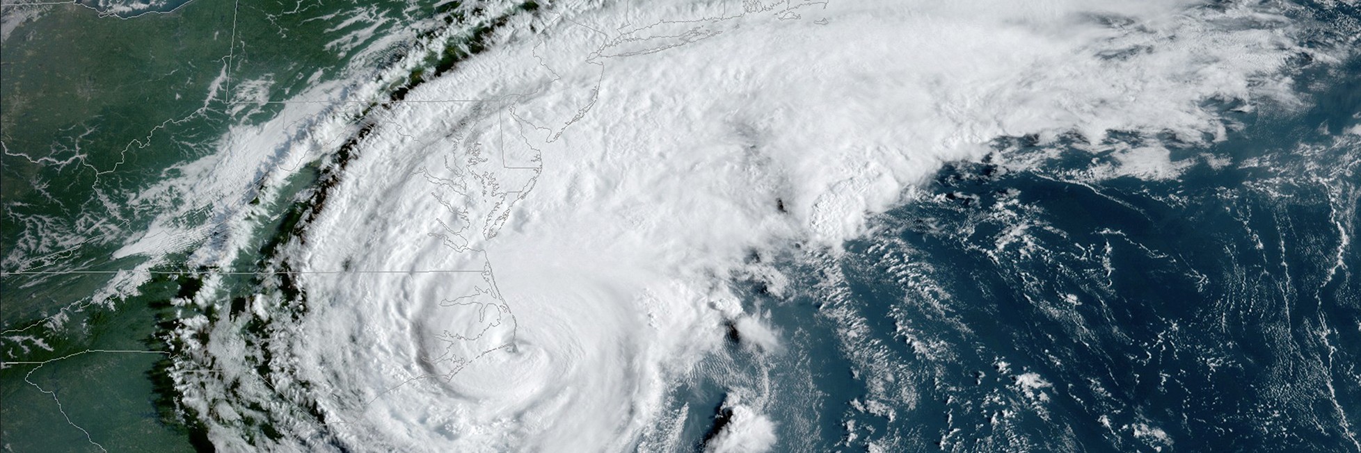
Leveraging 27 years of radar scans from Hurricane Hunter aircraft, NOAA and partners reveal new insights into one of the most elusive phases of the tropical cyclone lifecycle – vertical alignment of the vortex, a critical precursor to rapid intensification. This study is the first to use decades of radar observations to identify the storm […]
July 22, 2026
Read More News


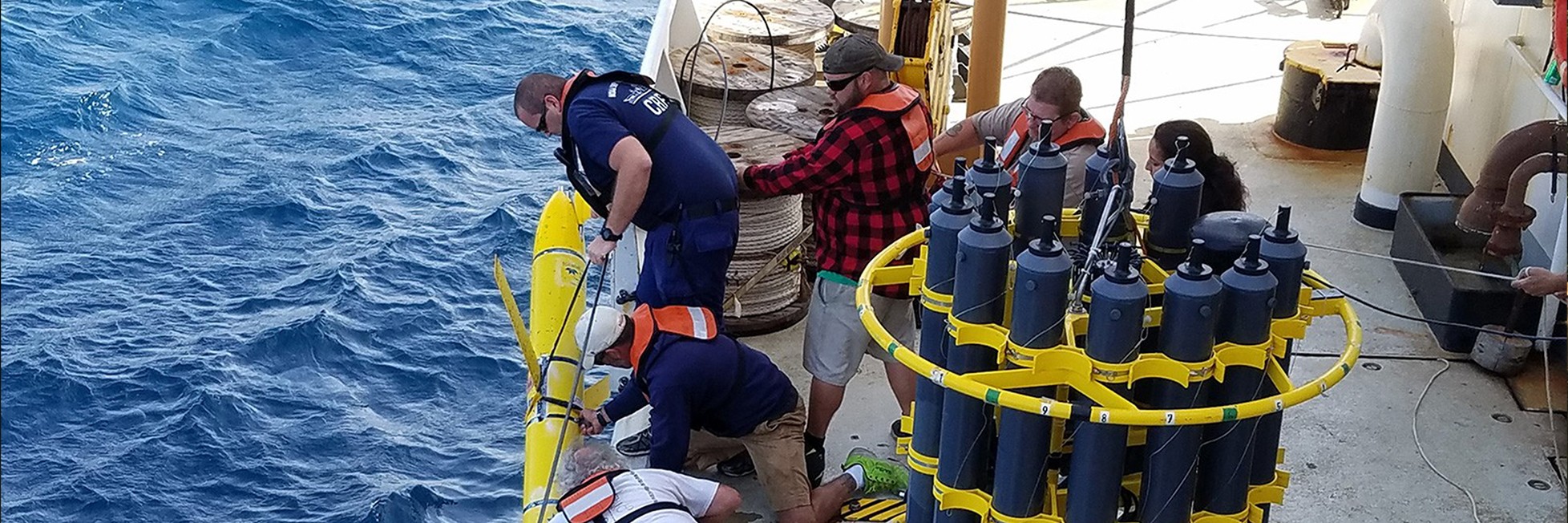
Hurricane, Climate, Coastal and Ocean Research.
Our Research Makes an Impact
Project: Monitoring the Ocean Improves Weather Forecasts
AOML plays a key role in collecting and maintaining sustained ocean observations that monitor the temperature and salinity of ocean features using drifters, Argo floats, XBTs, moorings, and other platforms.
Impact: Adding Ocean Data from Directly Beneath a Storm Leads to More Accurate Hurricane Forecasts
Unmanned Ocean Glider data improve our understanding of the current ocean state and are used to initialize hurricane models. Data from gliders passing under Hurricane Gonzalo improved the intensity forecast by one category on the Saffir Simpson Scale.
Project: Monitoring Commercially Important Sportfish Populations
AOML developed a sportfish model that the US Army Corps of Engineers adopted to evaluate the impacts of Everglades Restoration on south Florida’s economically and ecologically important sportfish populations.
Impact: Empowers Managers to Evaluate Different Scenarios and Plan for the Future
The majority of sportfish in south Florida are dependent upon healthy estuaries with natural freshwater runoff. The model shows how sea trout would respond to different management scenarios, giving managers actionable information.
Project: HWRF's High Resolution Moving Nest Module
AOML developed a high resolution moving nest in NOAA's regional hurricane model known as HWRF, increasing resolution over the storm environment. We transition the HWRF model into operations in joint partnership with NOAA's Environmental Modeling Center.
Impact: Improved Forecast Accuracy Better Informs Coastal Communities
The HWRF model has improved intensity forecasts by 10- 5 kts in the critical decision making period of 48-72 hours before landfall. This allows people to make informed decisions to prepare their families, homes, and communities.
Sargassum Research
Have you recently come across Sargassum and taken a picture? Maybe while you were at the beach or out on a boat. If you answered yes, you are encouraged to fill out NOAA’s citizen science Sargassum reporting form below to help scientists improve Sargassum monitoring and research.
Want to learn more about the large amount of Sargassum seaweed in the Atlantic Ocean? See NOAA’s frequently asked questions below.
What is Sargassum?
Sargassum is a type of floating brown algae, commonly called “seaweed.” These algae float at the sea surface, never attach to the sea floor, and they can aggregate to form large mats in the open ocean.
What research does NOAA’s Atlantic Oceanographic and Meteorological Laboratory or other parts of NOAA currently conduct on Sargassum?
Researchers at NOAA’s AOML and NOAA’s National Environmental Satellite Data, Information Service (NESDIS), and the University of South Florida developed the experimental Sargassum Inundation Report (SIR) to provide an overview of the extent of Sargassum in the ocean and the risk of Sargassum washing into coastal waters, beaches, and shorelines in the Caribbean, Gulf of America, and southeast Florida regions.
Research conducted at AOML in partnership with the University of Miami, the University of South Florida, and LGL Ecological Research (TX) is also aiding to identify how Sargassum extends across the Caribbean, Gulf of America, and tropical Atlantic, by assessing the role of ocean currents, winds, and waves in their motion. This work includes field experiments conducted to monitor the actual path of Sargassum using satellite tracking devices and surface drifters and satellite imagery, and physical representation of Sargassum in theoretical and numerical simulations. Please refer to the end of this document for a list of scientific manuscripts derived from this research.
Additionally, a collaboration between researchers with AOML and Fearless Fund studies how seaweed, including Sargassum, naturally removes carbon dioxide from ocean waters and sequesters it in the seaweed. This project seeks to provide a management solution to wide-scale inundation of beaches, while also repurposing the Sargassum.
As part of NOAA’s RESTORE Science Program, NOAA Fisheries, University of Southern Mississippi, and University of South Florida are evaluating Sargassum‘s role as fish nursery habitat in the northern Gulf of America. This project seeks to understand the relationship with Sargassum distribution and abundance and its capacity to serve as juvenile fish nurseries for recreationally and commercially important species. Results will be used to develop a forecast that can inform fisheries managers of changes in Sargassum and fish recruitment.
Scientists from the University of Rhode Island and Woods Hole Oceanographic Institute are examining the societal impacts of Sargassum blooms in the Caribbean as part of a study funded by NOAA’s National Centers for Coastal Ocean Science. The three-year long project assesses economic impacts, human well-being, and individual behaviors and perceptions associated with bloom events, as well as extensive engagement with community members and relevant stakeholders. Results from this study will aid local and regional coastal managers in managing Sargassum bloom and mitigation activities.
NOAA’s National Centers for Coastal Ocean Science (NCCOS) is initiating a new study to detect and analyze chemical contaminants in Sargassum mats from Puerto Rico, US Virgin Islands, and Florida. Scientists will be looking for concentrations of trace metals, organic, and per- and polyfluoroalkyl substances (PFAS) – many of which are highly persistent – in the samples. This research will provide managers with essential information to safely manage, dispose, repurpose or recycle Sargassum at local jurisdictions.
Further reading:
Tracking Sargassum Inundation Potential for Coastal Communities – NOAA/AOML
Chasing Sargassum: New Insights on Coastal Sargassum Invasions – NOAA/AOML
When might we see significant Sargassum inundation in Florida from the large mat in the Atlantic Ocean (March 2023)?
The motion, extent, and density of Sargassum is very complex – it grows, sinks, and moves according to ocean currents, winds, and waves. Therefore, sometimes it may not be possible to describe trajectories in advance, but rather a general description of how the average extension and density have changed. Projecting an accurate path of Sargassum is challenging and a current area of intense research. At this moment, the timing of Sargassum beaching cannot be predicted.
There are two main sources of Sargassum located in the Gulf of America, one is local and peaks in April-May, and the second one is the Caribbean Sea which peaks during the summer months. Large amounts of Sargassum are currently located in the Caribbean Sea, moving towards the Yucatan Peninsula, and spreading through the Gulf of America by the Loop Current.
The Loop Current flows through the Florida Straits and off the east Florida coast, where it is known as the Florida Current, and into the Gulf Stream as it heads north up the eastern coast of the US. The very strong Loop Current is now transporting moderate amounts of Sargassum that were previously located in the Caribbean Sea, with larger amounts potentially on the way. Some of the Sargassum in the Gulf of America also originated locally. Whether the Sargassum will beach on the coast of Florida, including the Florida Keys, will largely depend on the local wind, wave, and tide conditions. Given the complexity of its motion, growth, and decay, it is not possible to forecast the timing of beaching. However, given the size and number of the current Sargassum patches, there is a strong chance that Sargassum carried by the Florida Current may reach the Florida coast despite wind and wave conditions. As of mid March 2023, satellite observations indicate that some of this Sargassum has already reached the northern coast of Cuba.
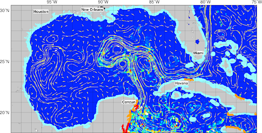
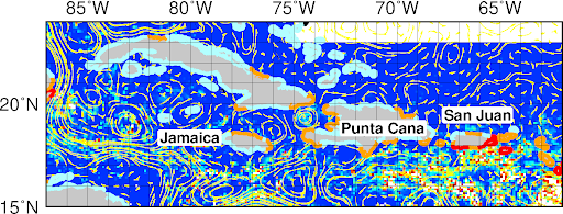
Maps showing Sargassum patches as derived from satellite images and reported weekly through the AOML experimental Sargassum Inundation Reports (link)

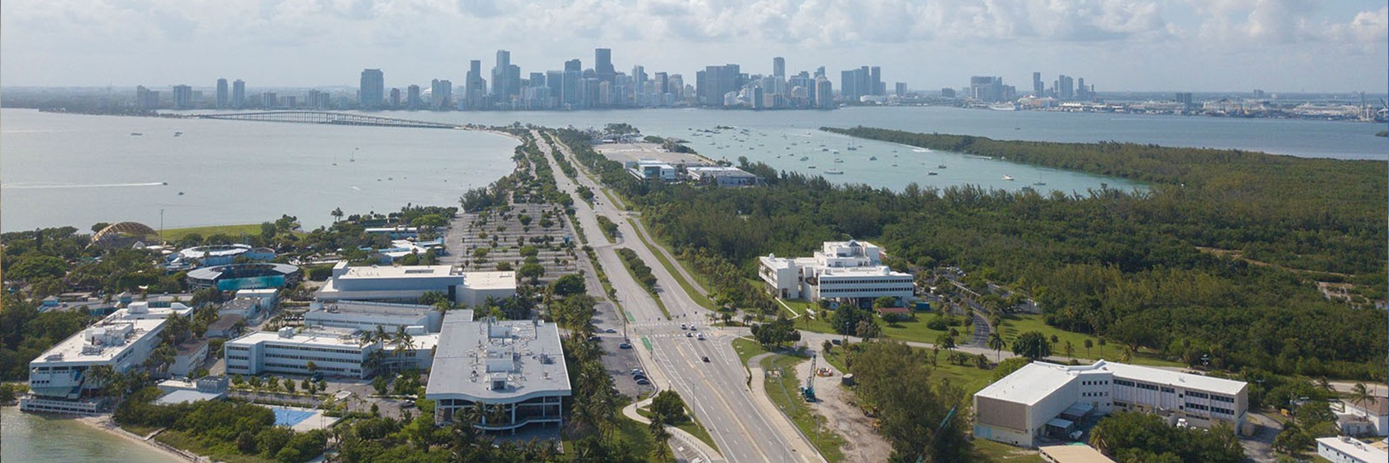
Explore the NOAA Atlantic Oceanographic and Meteorological Laboratory (AOML)
Through Our Virtual Tour
Our Mission
To conduct and transition world-class Earth system research, with a focus on the Atlantic Ocean region, to inform: the accurate forecasting of extreme weather and ocean phenomena, the management of marine resources, and an understanding of climate change and associated impacts, thereby improving ocean and weather services for the region, the nation, and the world.
AOML & GFDL’s Grassroots Collaboration
New Opportunities in a Virtual Environment
“This is a great starting point; it gave people a list of more than 10 topics with researchers at both labs working on similar problems. We now know who is a person we can contact, and that they are interested in collaborating because they gave a talk at the workshop.”
-Renellys Perez, Organizer and Participant

Frequently Asked Questions about Hurricanes
Why Don't Nuclear Weapons Destroy Hurricanes?
The amount of energy that a storm produces far outweighs the energy produced by one nuclear weapon. Additionally, the downside of radioactive fallout from such an operation would far outweigh the benefits and may not even alter the storm.
For more info click here.
How Much Energy is Released from a Hurricane?
The energy released from a hurricane can be explained in two ways: the total amount of energy released by the condensation of water droplets (latent heat), or the amount of kinetic energy generated to maintain the strong, swirling winds of a hurricane. The vast majority of the latent heat released is used to drive the convection of a storm, but the total energy released from condensation is 200 times the world-wide electrical generating capacity, or 6.0 x 10¹⁴ watts per day. If you measure the total kinetic energy instead, it comes out to about 1.5 x 10¹² watts per day, or ½ of the world-wide electrical generating capacity. It would seem that although wind energy seems the most obvious energetic process, it is actually the latent release of heat that feeds a hurricane’s momentum.
For more info click here.
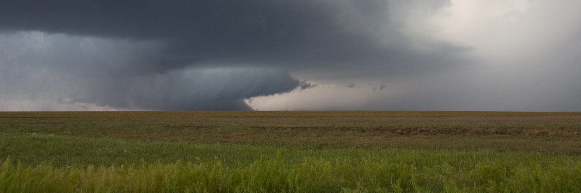
What Causes Tropical Cyclones?
The tropical atmosphere is often unstable. The amount of energy accumulated in the lower layers though the evaporation of water eventually overcomes any stable cap. This allows clusters of thunderstorms to form. These clusters move along with the prevailing winds as tropical disturbances. Occasionally, cyclonic circulations will develop within these disturbances. These circulations can be amplified and the disturbance will form a tropical cyclone. Only about 10% of disturbances become tropical cyclones, so large-scale influences impinging on such disturbances play a big role in cyclone formation.
For more info click here.
Why are Tropical Cyclone Winds Usually Stronger on One Side?
A hurricane is usually a symmetrical spiral. But if it is moving forward, then this motion makes the wind field asymmetrical. The side of the spiral with winds blowing in the direction of movement will add the forward speed to the wind speed. The side of the spiral with the wind blowing in the opposite direction will be subtract the forward speed from the wind speed.
For example, a hurricane with 90mph winds moving forward at 10mph would have a 100mph wind speed on the forward-moving side and 80 mph on the side with winds blowing backward to the motion.
For more info click here.
How are Hurricanes Named?
Names are assigned to organized tropical cyclones once their winds exceed 39 mph (17.5 m/s, 34 knots). The names are drawn from a list that is created prior to the season by the United Nations’ World Meteorological Organization. Each tropical cyclone basin has its own name list, which is maintained by a WMO Regional Committee. If a particularly damaging storm occurs, the name of that storm can be retired. If a storm happens to move across basins, it keeps the original name. The only time it is renamed if it dissipates to a tropical disturbance and then reforms.
For more info click here.