Hurricanes
Frequently Asked Questions
(Revised September 10, 2025)
Real-Time Information

For the latest current information about the tropics visit the National Hurricane Center.
Explore Alternative Formats like NOAA Weather Radio and Forecast RSS brought to you by the National Hurricane Center.
Hurricane Season Information
Hurricane Awareness week runs from May 25th through May 31st and is a great time to get your hurricane kit and plans up to date. The Atlantic hurricane season is June 1st to November 30th. In the East Pacific, it runs from May 15th to November 30th. For more information: When is Hurricane Season?
NOAA’s seasonal outlook is published here: NOAA Seasonal Outlook
The Saffir-Simpson Scale
The Saffir-Simpson Scale classifies hurricane-strength tropical cyclones into five categories (1-5) based on maximum sustained wind speed. Major hurricanes (also called intense hurricanes) fall into categories 3, 4, and 5 on the Saffir-Simpson Scale. A super-typhoon reaches category 4 or 5 on the Saffir-Simpson Scale.
Jump to FAQ Headers
A tropical cyclone is a generic term for a low-pressure system that formed over tropical waters (25°S to 25°N) with thunderstorm activity near the center of its closed, cyclonic winds. Tropical cyclones derive their energy from vertical temperature differences, are symmetrical, and have a warm core.
If it lacks a closed circulation it is called a tropical disturbance. If it has a closed circulation but under 39 mph (34 knots, or 17 meters per second) maximum sustained surface winds, it is called a tropical depression. When winds exceed that threshold, it becomes a tropical storm and is given a name. Once winds exceed 74 mph (64 knots, 33 meters per second) it will be designated a hurricane (in the Atlantic or East Pacific Oceans) or a typhoon (in the northern West Pacific).
Tropical Disturbances -> Tropical Depressions -> Tropical Storms -> Hurricane or Typhoon.
References:
Holland, G.J. (1993): “Ready Reckoner” – Chapter 9, Global Guide to Tropical Cyclone Forecasting, WMO/TC-No. 560, Report No. TCP-31, World Meteorological Organization; Geneva, Switzerland
Neumann, C.J. (1993): “Global Overview” – Chapter 1″ Global Guide to Tropical Cyclone Forecasting, WMO/TC-No. 560, Report No. TCP-31, World Meteorological Organization; Geneva, Switzerland
The “sub-tropical” in sub-tropical cyclone refers to the latitudes 25°N to 35°N (or °S). However, the term refers to cyclones whose characteristics are neither fully tropical nor extratropical. They are either asymmetrical with a warm core or symmetrical with a cold core. Sub-tropical cyclones can transform into tropical or extra-tropical storms depending on conditions.
The “extra-tropical” in extra-tropical cyclone refers to the latitudes 35°N to 65°N (or °S). However, the term refers to cyclones that get their energy from the horizontal temperature contrasts that exist in the atmosphere. Extra-tropical cyclones are low-pressure systems generally associated with cold fronts, warm fronts, and occluded fronts. They are asymmetrical and have a cold core.
A post-tropical cyclone is a former tropical cyclone that no longer possesses sufficient characteristics to be considered a tropical cyclone, such as convection at its center. Post-tropical cyclones can continue producing heavy rains and high winds. Former tropical cyclones that have become fully extra-tropical, sub-tropical, or remnant lows, are three classes of post-tropical cyclones.
Neutercane is a term no longer in use. It referred to small (<100 miles in diameter) sub-tropical low-pressure systems that are short-lived.
If you’re wondering, “what is UTC time?”, or “what is GMT time?”, or “What is Z time?”, the answer is they are time schemes. Universal Time Coordinated (UTC) used to be Greenwich Mean Time and Zulu Time (Z). This is the time at the Prime Meridian given in hours and minutes on a 24 hour clock. Most satellite pictures will give the time code next to the time taken with a UTC, GMT, or Z, but they are the same time zone. The conversion table for local times can be found below.
On most satellite pictures and radar images the time will be given. If it’s not in local time then it will usually be given as UTC, GMT, or Z time.
To convert this to your local time it is necessary to subtract the appropriate number of hours for the Western Hemisphere or add the correct number of hours for the Eastern Hemisphere. And don’t forget the extra hour adjustment for Daylight Savings Time or Winter Time over Standard Time for your zone.
| Local Time Zone | Time Adjustment (hours) |
| Atlantic Daylight Time (ADT) | -3 |
| Atlantic Standard Time (AST) Eastern Daylight Time (EDT) |
-4 |
| Eastern Standard Time (EST) Central Daylight Time (CDT) |
-5 |
| Central Standard Time (CST) Mountain Daylight Time (MDT) |
-6 |
| Mountain Standard Time (MST) Pacific Daylight Time (PDT) |
-7 |
| Pacific Standard Time (PST) Alaskan Daylight Time (ADT) |
-8 |
| Alaskan Standard Time (ASA) | -9 |
| Hawaiian Standard Time (HAW) | -10 |
| New Zealand Standard Time (NZT) International Date Line Time (IDLE) |
+12 |
| Guam Standard Time (GST) Eastern Australian Standard Time (EAST) |
+10 |
| Japan Standard Time (JST) | +9 |
| China Coast Time (CCT) | +8 |
| West Australia Standard Time (WAST) | +7 |
| Russian Time Zone 5 (ZP5) | +6 |
| Russian Time Zone 4 (ZP4) | +5 |
| Russian Time Zone 3 (ZP3) | +4 |
| Bagdad Time (BT) Russian Time Zone 2(ZP2) |
+3 |
| Eastern European Time (EET) Russian Time Zone 1(ZP1) |
+2 |
| Central European Time (CET) French Winter Time (FWT) Middle European Time (MET) Swedish Winter Time (SWT) Middle European Winter Time (MEWT) |
+1 |
| Western European Time (WET) Greenwich Mean Time (GMT) |
0 |
Central Dense Overcast (CDO) – This is the cirrus cloud shield that results from the thunderstorms in the eyewall of a tropical cyclone and its rainbands. Before the tropical cyclone reaches hurricane strength (33 m/s, 64 kts, 74mph), typically the CDO is uniformly showing the cold cloud tops of the cirrus with no eye apparent. Once the storm reaches the hurricane strength threshold, usually an eye can be seen in either the infrared or visible channels of the satellites. Tropical cyclones that have nearly circular CDO’s are indicative of favorable, low vertical shear environments.
Tropical Upper Tropospheric Trough- A “TUTT” is a Tropical Upper Tropospheric Trough. A TUTT low is a TUTT that has completely cut-off. TUTT lows are more commonly known in the Western Hemisphere as an “upper cold low”. TUTTs are different than mid-latitude troughs in that they are maintained by subsidence warming near the tropopause which balances radiational cooling. TUTTs are important for tropical cyclone forecasting as they can force large amounts of vertical wind shear over tropical disturbances and tropical cyclones which may inhibit their strengthening. There are also suggestions that TUTTs can assist tropical cyclone genesis and intensification by providing additional forced ascent near the storm center and/or by allowing for an efficient outflow channel in the upper troposphere.
Prior to the 20th century, hurricane names were inspired by everything from saints’ feast days, ship names, to unpopular politicians. In 1950, the National Hurricane Center officially began designating Atlantic hurricanes with code names and then women’s names. In 1979, naming responsibility was passed to a committee of the World Meteorological Organization who used alternating men and women’s names following the practice adopted by Australia’s Bureau of Meteorology three years earlier in 1975.
Currently, there are six yearly lists used in rotation found here. If a particularly damaging storm occurs, the name of that storm is retired. Storms retired in 2017 include Harvey, Irma, Maria, and Nate. If there are more storms than names on the list in a given season, an auxiliary name list is used. Lastly, if a storm happens to move across basins, it keeps the original name. The only time it is renamed is in the case that it dissipates to a tropical disturbance and then reforms.
In the Atlantic basin, tropical cyclone names are “retired” (not to be used again for a new storm) if it is deemed to be quite noteworthy because of the damage and/or deaths it caused. This is to prevent confusion with a historically well-known cyclone with a current one in the Atlantic basin. Sometimes names are removed for other reasons, such as cultural considerations or politics.
History of Hurricane Naming
For much of history, tropical cyclones were only given designations post facto. After they had come ashore and done much destruction, they would be commemorated by being named either for the Saint’s feast day they happened on (such as the San Felipe hurricanes in 1876 & 1928) or by some characteristic (the Salty hurricane 1810, the Yankee hurricane 1935).
The first use of a proper name for a tropical cyclone was by Clement Wragge, an Australian forecaster late in the 19th century. He first designated tropical cyclones by the letters of the Greek alphabet, then started using South Sea Island girls’ names. When the newly constituted Australian national government failed to create a federal weather bureau and appoint him director, Wragge began naming cyclones “after political figures whom he disliked. By properly naming a hurricane, the weatherman could publicly describe a politician (who perhaps was not too generous with weather-bureau appropriations) as ‘causing great distress’ or ‘wandering aimlessly about the Pacific.’ (Dunn and Miller 1960)
Although Wragge’s naming practice lapsed when his Queensland weather bureau closed in 1903, forty years later the idea inspired author George R. Stewart. In his 1941 novel “Storm”, a junior meteorologist named Pacific extratropical storms after former girlfriends. The novel was widely read, especially by US Army Air Forces and Navy meteorologists during World War II. When Reid Bryson, E.B. Buxton, and Bill Plumley were assigned to a USAAF base on Saipan in 1944 they had to forecast any tropical cyclones affecting operations. They decided (à la Stewart) to name them after their wives. In 1945, the armed services publicly adopted a list of women’s names for typhoons of the western Pacific using the names of officers’ wives assigned to forward forecast centers on Guam and the Philippines. However, the Air Forces were unable to persuade the U.S. Weather Bureau (USWB) to adopt a similar practice for Atlantic hurricanes.
Starting in 1947, the Air Force Hurricane Office in Miami began designating tropical cyclones of the North Atlantic Ocean using the Army/Navy phonetic alphabet (Able-Baker-Charlie-etc.) in internal communications. During the busy 1950 hurricane season there were three hurricanes occurring simultaneously in the Atlantic basin, causing considerable confusion. Grady Norton of the USWB’s Miami Hurricane Warning Center then decided to use the Air Force’s naming system in public bulletins and in his year-end summary. By the next year, these names began appearing in newspaper articles.
This practice proved popular. However, in 1952 a new International phonetic alphabet was adopted (Alpha-Beta-Charlie-etc.) which caused some confusion about which names were to be used. So in 1953, the US Weather Bureau finally acceded to the Armed Services’ practice of using women’s names. This was both controversial and popular. In 1978, under political pressure, the US National Hurricane Center (NHC) requested that the WMO’s Region IV Hurricane Committee (which had just taken control of the list) switch to a hurricane name list that alternated men’s and women’s names following the practice adopted by Australia’s Bureau of Meteorology in 1975. This was first implemented in the eastern Pacific then in 1979 in the Atlantic.
A rare hurricane near Hawaii in 1950 was called Hiki (Hawai’ian for Able). In 1957, three storms were detected in the Central Pacific, and the military forecast centers called them Kanoa, Della and Nina. In 1959, another hurricane threatened the islands and the Weather Bureau designated it “Dot”. The next year an official name list for tropical cyclones was drawn up for the Northeast Pacific basin. In 1978, both men’s and women’s names were utilized, and in 1979 a separate list was created for the Central Pacific (from 140°W to 180°W) using Hawaiian names.
The Northwest Pacific basin tropical cyclones were given women’s names officially starting in 1945 and men’s names were also included beginning in 1979. As of 1 January 2000, tropical cyclones in the Northwest Pacific basin are now being named from a new and very different list. The new names contributed by all the nations and territories that are members of the WMO’s Typhoon Committee. These newly selected names have two major differences from the rest of the world’s tropical cyclone name rosters.
- The names by and large are not personal names. There are a few men’s and women’s names, but the majority are names of flowers, animals, birds, trees, or even foods, etc, while some are descriptive adjectives.
- The names will not be allotted in alphabetical order, but are arranged by contributing nation with the countries being alphabetized.
The Philippine weather service PAGASA maintains their own separate list of names for any tropical system that threatens their archipelago.
For many years the Indian Ocean cyclones were given alphanumeric designators. The Southwest Indian Ocean tropical cyclones were first named during the 1960/1961 season. The North Indian Ocean region tropical cyclones were named as of 2006.
The Australian and South Pacific region (east of 90E, south of the equator) started giving women’s names to the storms for the 1964/1965 season and both men’s and women’s names for the 1974/1975 season. For the 2008/2009 season the three separate name lists of the different BoM forecast centers were consolidated into one list.
A rare South Atlantic storm in 2004 was post facto given the name Catarina. Another such system in 2010 was designated Anita after the fact. Starting in 2011, a name list was begun for the South Atlantic basin using mostly Brazilian designations.
Reference:
Dunn, G.E. and B.I. Miller (1960): Atlantic Hurricanes, Louisiana State Univ. Press, Baton Rouge, Louisiana, 377pp
Skilton, Liz, (2019): Tempest, Louisiana State Univ. Press, Baton Rouge, Louisiana, 306pp
Well, we all found out the answer in 2005 and 2020. In those years, when they ran through the name list they then use the Greek alphabet : Alpha, Beta, Gamma, Delta, Epsilon,… etc. . In 2020, they made it to a Iota on the list. Since several Greek-letter storms that year were damaging enough to have their names retired, it was decided to scrap this scheme and instead come up with an auxiliary name list each year. The same was done for the East Pacific name lists.
In the Central and West Pacific they have a perpetual lists of names, so when one list is through they simply start on the next.
Since 1978, the United Nations’ World Meteorological Organization, a group representing some 120 different countries, has used pre-determined lists of names for tropical storms for each ocean basin of the world. The Atlantic basin, which falls under Regional Association IV, has a six year supply of names with 21 names for each year. Why 21 names? Well, the letters Q, U, X, Y and Z are not used because names beginning with those letters are in short supply (you would need at least 3 male and 3 female names for each letter, plus a backup supply for those retired). Think about it; how many men and women do you know whose names begin with these letters?
When a damage or casualty producing storm like Mitch, Andrew, or Katrina strikes, the country most affected by the storm may recommend to the World Meteorological Organization’s Regional Association that the name be “retired.” Retiring a name is an act of respect for its victims, and reduces confusion in the insurance, legal or scientific literature. A retired name is replaced with a like-gender name beginning with the same letter. For example, Honduras recommended (1998) the name Mitch be retired and proposed the replacement name, Matthew, for consideration (and vote) by the 25-member countries of the Regional Association-IV. Eighty-three names have been retired in the Atlantic basin.
The names used on the list must meet some fundamental criteria. They should be short, and readily understood when broadcast. Further the names must be culturally sensitive and not convey some unintended and potentially inflammatory meaning. The potential for misunderstanding increases when you figure that in the Atlantic basin there are twenty-four countries, reflecting an international mix of English, Spanish and French cultures.
Typically, over the historical record, about one storm each year causes so much death and destruction that its name is considered for retirement. This means that in a “normal” year, the odds are about 1 in 8 of requiring a replacement name, given that over the last 57 years (of reliable record) we’ve averaged slightly over 8 tropical storms and hurricanes per season (actually 8.6). So, it’s more likely that letters/ names toward the front of the alphabet (letters A through H) might be retired.
The Region IV Naming Committee has a rather large file folder of nominated names that have already been submitted. The next time the need arises and it’s a storm affecting mainly the United States, the Committee will be casting about for a replacement tropical cyclone name. They will take out this file to make a selection. But as we say, it’s pure chance from there.
The Automated Tropical Cyclone Forecast (ATCF) system was developed for the Joint Typhoon Warning Center in 1988. It is used by computer software to identify tropical cyclones and assist in the generation of forecast messages. In order to distinguish different tropical cyclones that might be occurring simultaneously, a distinct alphanumeric code is assigned to each cyclone once it develops a closed circulation. This code system was adopted by other warning centers in order to facilitate the passing of storm information and reduce confusion.
The code designation consists of two letters designating the oceanic basin (“AL” for Atlantic, “EP” for Eastern Pacific, “CP” for Central Pacific and “WP” for Western Pacific), a two-digit number designating the sequential number of that particular cyclone for that basin in the year, and lastly a four-digit year number. So, the first depression to form in the Atlantic for 2001 would be AL012001, the third depression for the Central Pacific in 1999 would be CP031999.
A cyclone retains its ATCF code designation as long as it remains a distinct tropical vortex. Even if it becomes a named tropical storm or hurricane the software will still track it by its ATCF code.
AL90, AL92, 92L from the Tropical Discussions
Oftentimes, hurricane specialists become curious about disturbances in the tropics long before they form into tropical depressions and are given a tropical cyclone number. In order to alert forecasting centers that they are investigating such a disturbance and that they wish to have it tracked by the various forecast models, the specialist will attach a 9-series number to it. The first such disturbance of the year will be designated 90, the next 91, and so on until 99. After that, they restart the sequence with 90 again. The purpose of these numbers is to clarify which disturbance they are tracking as there are often more than one happening at the same time.
To further clarify matters, each number is accompanied by a two-letter code designating which tropical cyclone basin the disturbance is in. “AL” is used for the Atlantic basin (including the Caribbean Sea and Gulf of America), “EP” for the Eastern Pacific, “CP” for Central Pacific, and “WP” for the Western Pacific.
In discussions, these designations will be shortened to 90L, 91L, and so forth. They may also be referred to as ‘Invest 90L’. However, once a disturbance is designated a tropical depression this 9-series number will be dropped and an ATCF code number will be assigned in its place.
You may also occasionally see an 8-series number, such as AL82. This means that this is a test investigation. There is no particular disturbance that the specialists are interested in, they’re just running a test of the system to make sure communications and software are running properly.
In the Atlantic basin, tropical cyclone names are “retired” (not to be used again for a new storm) if it is deemed to be quite noteworthy because of the damage and/or deaths it caused. This is to prevent confusion with a historically well-known cyclone and a current one in the Atlantic basin. Sometimes names are removed for other reasons, such as cultural considerations or politics. The following list gives the names that have been retired and the year of the storm in question.
| Audrey 1957, Agnes 1972, Anita 1977, Allen 1980, Alicia 1983, Andrew 1992, Allison 2001 |
| Betsy 1965, Beulah 1967, Bob 1991 |
| Connie 1955, Carla 1961, Cleo 1964, Carol 1965, Camille 1969, Celia 1970, Carmen 1974, Cesar 1996, Charley 2004 |
| Diane 1955, Donna 1960, Dora 1964, David 1979, Diana 1990, Dennis 2005, Dean 2007, Dorian 2019 |
| Edna 1968, Eloise 1975, Elena 1985, Erika 2015 |
| Flora 1963, Fifi 1974, Frederic 1979, Fran 1996, Floyd 1999, Fabian 2003, Frances 2004, Felix 2007, Florence 2018, Fiona 2022 |
| Greta 1978, Gloria 1985, Gilbert 1988, Georges 1998, Gustav 2008 |
| Hazel 1954, Hattie 1961, Hilda 1964, Hugo 1989, Hortense 1996, Harvey 2017 |
| Ione 1955, Inez 1966, Iris 2001, Isidore 2002, Isabel 2003, Ivan 2004, Ike 2008, Igor 2010, Irene 2011, Ingrid 2013, Irma 2017, Ida 2021, Ian 2022 |
| Janet 1955, Joan 1988, Juan 2003, Jeanne 2004, Joaquin 2015 |
| Klaus 1990, Keith 2000, Katrina 2005 |
| Luis 1995, Lenny 1999, Lili 2002, Laura 2020 |
| Marilyn 1995, Mitch 1998, Michelle 2001,Matthew 2016, Maria 2017, Michael 2018 |
| Noel 2007, Nate 2017 |
| Opal 1995,Otto 2016 |
| Paloma 2008 |
| Roxanne 1995, Rita 2005 |
| Stan 2005, Sandy 2012 |
| Tomas 2010 |
| Wilma 2005 |
| Eta 2020 |
| Iota 2020 |
Name retired because of previous storm in 1954 with the same name.
Although rarer, some East Pacific names have been retired from the list. The climatology of this basin has most hurricanes moving away from the shore, so chances are rare that these storms would adversely affect people necessitating the name be retired.
| Adele 1970, Adolph 2001, Alma 2008 |
| Fico 1978, Fefa 1991 |
| Hazel 1965 |
| Iva 1988, Ismael 1995, Israel 2001, Isis 2016 |
| Knut 1988, Kenna 2002 |
| Manuel 2013 |
| Odile 2014 |
| Pauline 1997, Patricia 2015 |
Name retired because of political or social considerations
A few Central Pacific names have been retired from their list. Most of them were removed for inflicting damage or adversely affecting the Hawaiian Islands. However, some have moved into the western Pacific to cause destructions, prompting their retirement.
| Iwa 1982, Iniki 1992, Ioke 2006 |
| Paka 1997 |
Names retired before the 2000 season come from the name lists used by the Joint Typhoon Warning Center. Since 2000, the names removed come from the name lists used by the Japan Meteorological Agency. Most of the retired names inflicted significant damage to the nations affected.
| Bess 1974, Bess 1982, Bilis 2006, Bopha 2012 |
| Chanchu 2006, Chataan 2002, Conson 2021 |
| Durian 2006 |
| Fanapi 2010, Fitow 2013, Faxai 2019 |
| Goni 2020 |
| Hanuman 2002, Haiyan 2013, Halma 2016, Hagibis 2019, Hinnamnor 2022 |
| Ike 1984, Imbudo 2003 |
| Karen 1962, Ketsana 2009, Kodo 2002, Koppu 2015, Kammuri 2019, Kompasu 2021 |
| Lucille 1960, Longwang 2005, Lekima 2019, Linfa 2020 |
| Maemi 2003, Matsa 2005, Mike 1990, Mireille 1991, Morakot 2009, Mujigae 2015, Melor 2015, Meranti 2016, Molave 2020, Malakas 2022, Megi 2022, Ma-on 2022 |
| Nabi 2005, Nock-ten 2016, Noru 2022, Nalgae 2022 |
| Ophelia 1960, Omar 1992 |
| Parma 2009, Pongsona 2002, Phanfone 2019 |
| Rananim 2004, Roy 1988, Rusa 2002, Rammasun 2014, Rai 2021 |
| Saomai 2006, Sudal 2004, Sonamu 2013, Soudelor 2015, Sarika 2016 |
| Thelma 1991, Tingting 2004 |
| Utor 2013 |
| Vamei 2001, Vicente 2012, Vongfong 2020, Vamco 2020 |
| Washi 2011 |
| Xangsane 2006 |
| Yanyan 2004 |
Bess 1974 was retired after the season and replaced with Bonnie. In 1979, new name lists featuring both sexes were introduced and Bess was added back. In 1982, Bess was again retired and replaced with Brenda.
HURRICANE was derived from the name of the Mayan god ‘Hurakan’, one of their creator gods, who blew his breath across the chaotic water and brought forth dry land. Later he destroyed the men of wood with a great storm and flood. Through trade Mayan religious beliefs spread throughout the Caribbean. When Columbus met the Taino tribe on Hispañola, they told him about ‘Hurican’, an evil god of storms. Spanish sailors began to refer to these tropical tempests by the name of the Taino storm god. Their lingo soon spread to English, French, and Dutch sailors who plied the same waters. Many New World colonists adopted some version of Hurakan for the horrific storms they endured.
Throughout history there have been many alternative spellings in different languages: foracan, foracane, furacana, furacane, furicane, furicano, haracana, harauncana, haraucane, haroucana, harrycain, hauracane, haurachana, herican, hericane, hericano, herocane, herricao, herycano, heuricane, hiracano, hirecano, hurac[s]n, huracano, hurican, hurleblast, hurlecan, hurlecano, hurlicano, hurrican, hurricano, hyrracano, urycan, hyrricano, jimmycane, oraucan, uracan, uracano
In order for a tropical cyclone to form, several atmospheric and marine conditions must be met.
Temperature & Humidity: Ocean waters should be 80° Fahrenheit at the surface and warm for a depth of 150 feet, because warm ocean waters fuel the heat engines of tropical cyclones. They also need an atmosphere which cools fast enough with increasing height so that the difference between the top and bottom of the atmosphere can create thunderstorm conditions. A moist mid-troposphere (3 miles high) is also needed because dry air ingested into thunderstorms at mid-level can kill the convection.
Spin & Location: The Coriolis force is an apparent force that deflects movement of air to the right coming from the Northern hemisphere and to the left coming from the Southern hemisphere. The force is greatest at the poles and zero at the equator, so the storm must be at least 300 miles from the equator in order for the Coriolis force to create the spin. This force causes hurricanes in the Northern hemisphere to rotate counter-clockwise, and in the southern hemisphere to rotate clockwise. This spin may play some role in helping tropical cyclones to organize. (As a side note: the Coriolis force is not strong enough to affect small containers such as in sinks and toilets. The notion that the water flushes the other way in the opposite hemisphere is a myth.)
Wind: Low vertical wind shear (the change of wind speed and direction with height) between the surface and the upper troposphere favors the thunderstorm formation, which provides the energy for tropical cyclones. Too much wind shear will disrupt or weaken the convection.
Having these conditions met is necessary but not sufficient, as many disturbances that appear to have favorable conditions do not develop. Past work (Velasco and Fritsch 1987, Chen and Frank 1993, Emanuel 1993) has identified that large thunderstorm systems (called mesoscale convective complexes) often produce an inertially stable, warm core vortex in the trailing altostratus decks of the MCC. These mesovortices have a horizontal scale of approximately 100 to 200 km [75 to 150 mi], are strongest in the mid-troposphere (5 km [3 mi]) and have no appreciable signature at the surface. Zehr (1992) hypothesizes that genesis of the tropical cyclones occurs in two stages:
Stage 1 occurs when the convective cluster produces a mesoscale vortex. Stage 2 occurs when a second blow up of convection at the mesoscale vortex initiates the intensification process of lowering central pressure and increasing inflowing winds. Stage 3 is when bands of rainshowers form along the inflowing winds. Stage 4 then occurs when an eyewall and eye begin to form at the center of circulation.
References: Graham, N. E., and T. P. Barnett, 1987: Sea surface temperature, surface wind divergence, and convection over tropical oceans. Science, No.238, pp. 657-659.
Gray, W.M. (1968): “A global view of the origin of tropical disturbances and storms” Mon. Wea. Rev., 96, pp.669-700
Gray, W.M. (1979): “Hurricanes: Their formation, structure and likely role in the tropical circulation” Meteorology Over Tropical Oceans. D. B. Shaw (Ed.), Roy. Meteor. Soc., James Glaisher House, Grenville Place, Bracknell, Berkshire, RG12 1BX, pp.155-218
Chen, S.A., and W.M. Frank (1993): “A numerical study of the genesis of extratropical convective mesovortices. Part I: Evolution and dynamics” J. Atmos. Sci., 50, pp.2401-2426
Emanuel, K.A. (1993): “The physics of tropical cyclogenesis over the Eastern Pacific. Tropical Cyclone Disasters J. Lighthill, Z. Zhemin, G. J. Holland, K. Emanuel (Eds.), Peking University Press, Beijing, 136-142
Palmen, E. H., 1948: On the formation and structure of tropical cyclones. Geophysica , Univ. of Helsinki, Vol. 3, 1948, pp. 26-38.
Velasco, I., and J.M. Fritsch (1987): “Mesoscale convective complexes in the Americas” J. Geophys. Res., 92, pp.9561-9613
Zehr, R.M. (1992): “Tropical cyclogenesis in the western North Pacific. NOAA Technical Report NESDIS 61, U. S. Department of Commerce, Washington, DC 20233, 181 pp.
In addition to hurricane-favorable conditions such as temperature and humidity, many repeating atmospheric phenomenon contribute to causing and intensifying tropical cyclones. For example, African Easterly Waves (AEW) are winds in the lower troposphere (ocean surface to 3 miles above) that originate and travel from Africa at speeds of about 3-mph westward as a result of the African Easterly Jet. These winds are seen from April until November. About 85% of intense hurricanes and about 60% of smaller storms have their origin in African Easterly Waves.
The Saharan Air Layer (SAL) is another significant seeding phenomenon affecting tropical storms. It is a mass of dry, mineral-rich, dusty air that forms over the Sahara from late spring to early fall and moves over the tropical North Atlantic every 3-5 days at speeds of 22-55mph (10-25 meters per second). These air masses are 1-2 miles deep and exist in the lower troposphere. They can be as wide as the continental US and have significant moderating impacts on tropical cyclone intensity and formation because the dry, intense air can deprive the storm of moisture and wind shear can interfere with its convection. However, disturbances on the periphery of the Saharan Air Layer can receive a boost in their convection and spin.
An upper atmospheric perturbation known as the Madden-Julian Oscillation (MJO) can travel around the globe on a time-scale of weeks. As its positive phase passes over an area it can bring favorable conditions for convection, while its negative phase can suppress it. This can affect forming tropical cyclones either giving them a boost or hindering them.
The climatic fluctuation in the Pacific Ocean known as the El Niño-Southern Oscillation (ENSO) can affect Atlantic tropical cyclone development by increasing or decreasing (depending on ENSO phase) the vertical wind shear over the western side of the basin.
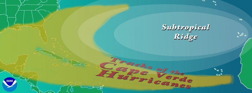 Cape Verde-type hurricanes are Atlantic basin tropical cyclones that develop into tropical storms fairly close (<1000 km [600 mi] or so) to the Cape Verde Islands and then become hurricanes before reaching the Caribbean. Typically, this may occur in August and September, but in rare years (like 1995) this may occur in late July and/or early October. The numbers range from none to around five per year – with an average of 2 per year.
References: Dunn, G. E., 1940: “Cyclogenesis in the tropical Atlantic” Bull. Amer. Meteor. Soc., 21, pp.215-229
Riehl, H., 1945: “Waves in the easterlies and the polar front in the tropics” Misc. Rep. No. 17, Department of Meteorology, University of Chicago, 79 pp.
Burpee, R. W., (1972): “The origin and structure of easterly waves in the lower troposphere of North Africa” J. Atmos. Sci., 29, pp.77-90
Burpee, R. W., (1974): “Characteristics of the North African easterly waves during the summers of 1968 and 1969” J. Atmos. Sci., 31, pp.1556-1570
Landsea, C.W. (1993): “A climatology of intense (or major) Atlantic hurricanes” Mon. Wea. Rev., 121, pp.1703-1713
Avila, L. A., and R. J. Pasch, 1995: “Atlantic tropical systems of 1993” Mon. Wea. Rev., 123, pp.887-896
When a tropical disturbance organizes into a tropical depression, the thunderstorms will begin to line up in spiral bands along the inflowing wind. The winds will begin to increase, and eventually the inner bands will close off into an eyewall, surrounding a central calm area known as the eye. This usually happens around the time wind speeds reach hurricane force. When the hurricane reaches its mature stage, eyewall replacement cycles may begin. Each cycle will be accompanied by fluctuations in the strength of the storm. Peak winds may diminish when a new eyewall replaces the old, but then re-strengthen as the new eyewall becomes established.
If the storm passes through an area of high vertical wind shear or dry air the storm could be weakened. However, if it continues to pick up moisture from a warm environment, then it could become a major hurricane.
Hurricanes are driven by larger scale circulation patterns. The predominant pattern in the tropics is the Subtropical ridge, a semi-permanent high pressure cell roughly located near the Tropic of Cancer or Capricorn (23°26′ N or S). In the Atlantic this ridge is often called the Bermuda High due to its location. South of the ridge the circulation drives tropical cyclones westward with a slight poleward component. But when the cyclone reaches the westward edge of the ridge it will tend to move around the high first poleward then easterly. This is known as recurvature.
This motion means that many Atlantic hurricanes may recurve back out to sea without ever making landfall. If a hurricane reaches the mid-latitudes, it can interact with fronts. Often the energy and moisture of tropical cyclones will be absorbed into such fronts, transitioning into extratropical low pressure storms. Studies have shown that this process can increase the unpredictability of mid-latitude weather downstream for days following.
However, some hurricanes will make landfall. Striking an island, especially a mountainous one, could cause its circulation to break down. If it hits a continent, a hurricane will be cut off from its supply of warm, moist maritime air. It will also begin to draw in dry continental air, which combined with increased friction over land leads to the weakening and eventual death of the hurricane. Over mountainous terrain this will be a quick end. But over flat areas, it may take two to three days to break down the circulation. Even then you are still left with a large pocket of tropical moisture which can cause substantial inland flooding. There have been studies on the rate of storm decay once they make landfall (Demaria Kaplan Decay Model).
References: Willoughby, H.E. (1990a): “Temporal changes of the primary circulation in tropical cyclones” J. Atmos. Sci., 47, pp.242-264
Willoughby, H.E., J.A. Clos, and M.G. Shoreibah (1982): “Concentric eye walls, secondary wind maxima, and the evolution of the hurricane vortex” J. Atmos. Sci., 39, pp.395-411
Powell, M.D., and S.H. Houston, 1996: “Hurricane Andrew’s wind field at landfall in South Florida. Part II: Applications to real -time analysis and preliminary damage assessment” Wea. Forecasting, 11, pp.329-349
Tuleya, R.E. (1994): “Tropical storm development and decay: Sensitivity to surface boundary conditions” Mon. Wea. Rev., 122, pp.291-304
Tuleya, R.E. and Y. Kurihara (1978): “A numerical simulation of the landfall of tropical cyclones” J. Atmos. Sci., 35, pp.242-257
Tropical cyclones – to a first approximation – can be thought of as being steered by the surrounding environmental flow throughout the depth of the troposphere (from the surface to about 12 km or 8 mi). Dr. Neil Frank, former director of the U.S. National Hurricane Center, used the analogy that the movement of hurricanes is like a leaf being steered by the currents in the stream, except that for with a hurricane the stream has no set boundaries.

In the tropical latitudes (typically equatorward of 20°-25°N or S), tropical cyclones usually move toward the west with a slight poleward component. This is because there exists an axis of high pressure called the subtropical ridge that extends east-west poleward of the storm. On the equatorward side of the subtropical ridge, general easterly winds prevail. However, if the subtropical ridge is weak – often times due to a trough in the jet stream – the tropical cyclone may turn poleward and then recurve back toward the east. On the poleward side of the subtropical ridge, westerly winds prevail thus steering the tropical cyclone back to the east. These westerly winds are the same ones that typically bring extratropical cyclones with their cold and warm fronts from west to east.
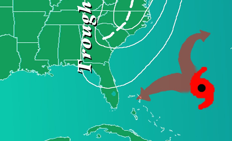
Many times it is difficult to tell whether a trough will allow the tropical cyclone to recurve back out to sea (for those folks on the eastern edges of continents) or whether the tropical cyclone will continue straight ahead and make landfall.
For more non-technical information on the movement of tropical cyclones, see Pielke and Pielke’s “Hurricanes: Their Nature and Impacts on Society”. For a more detailed, technical summary on the controls on tropical cyclone motion, see Elsberry’s chapter in “Global Perspectives on Tropical Cyclones”.
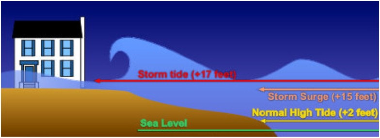
Storm surge is an abnormal rise of water generated by a storm’s winds blowing onshore.
Storm tide is the combination of the storm surge and astronomical tide as a result of a storm. Storm surge is caused by the force of high wind speeds acting on the ocean surface combined with the forward speed of the storm. The height of a storms surge is determined by the approaching angle of the storm as well as the coastline characteristics, such as the shape of the continental shelf and local geographic features, such as inlets.
The degree of vulnerability of any stretch of coast is dependent on a number of factors which includes the central pressure, intensity, forward speed, storm size, angle of approach, width and slope of the off-shore continental shelf, and local bays and inlets. The figure above illustrates the degree of storm surge threat for a “worst case scenario” Category 4 hurricane normalized along the coastline of the eastern and Gulf coasts of the United States.
The SLOSH Model
The Sea, Lake, and Overland Surges from Hurricanes (SLOSH) model is the computer model utilized by the National Oceanic and Atmospheric Administration (NOAA) for coastal inundation risk assessment and the operational prediction of storm surge.
The eastern seaboard and Gulf Coast of the United States, Puerto Rico, the Bahamas, the Virgin Islands, and Hawaii, are subdivided into 39 regions or “basins.” These areas represent sections of the coastline that are centered upon particularly susceptible features: inlets, large coastal centers of population, low-lying topography, and ports. The SLOSH model computes the maximum potential impact of the storm in these “computational domains” based on storm intensity, track, and estimates of storm size provided by hurricane specialists at the National Hurricane Center (NHC).
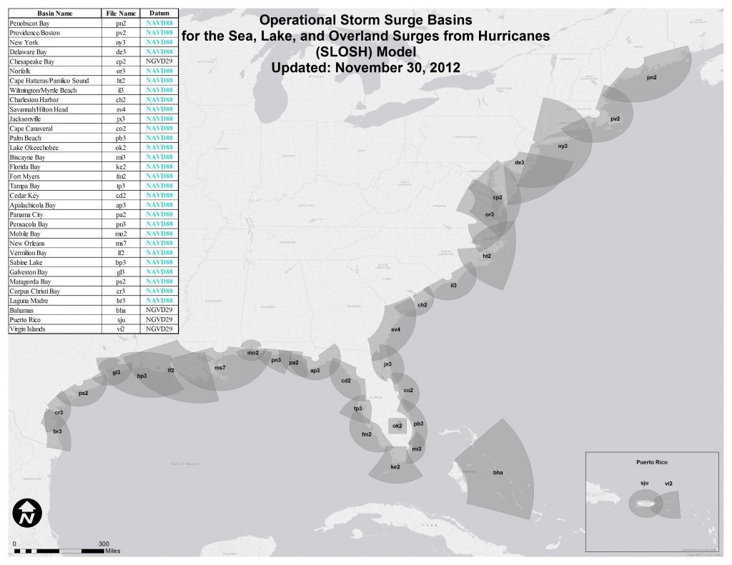
Currently, SLOSH basins are being updated at an average rate of 6 basins per year. SLOSH basin updates are ultimately governed by the Interagency Coordinating Committee on Hurricanes (ICCOH). ICCOH manages hazard and post-storm analysis for the Hurricane Evacuation Studies under FEMA’s Hurricane Program. Updates are driven by a number of different factors such as: changes to a basin’s topography/bathymetry due to a hurricane event, degree of vulnerability to storm surge, availability of new data, changes to the coast, and the addition of engineered flood protection devices (e.g. levees).
Sometimes these updates include higher grid size resolution to improve surge representation, increasing areas covered by hypothetical tracks for improved accuracy, conversion to updated vertical reference datums, and including the latest topography or bathymetric data for better representation of barrier, gaps, passes, and other local features.
The SLOSH model can generate several different products:
Deterministic runs
This is an operational product based on the official NHC track and intensity forecast of a tropical cyclone. Operational SLOSH runs are generated whenever a hurricane warning is issued, approximately 36 hours prior to arrival of tropical storm winds. It is run every 6 hours coinciding with the full advisory package. This is a single run product which can result in uncertainty because it is STRONGLY dependent on the accuracy of the storm track and timing. This product is intended to provide valuable surge information in support of rescue and recovery efforts.
Probabilistic (P-surge) runs
This is a graphical product using an ensemble of many SLOSH runs to create a Probabilistic Storm Surge (P-Surge) product. This is intended to be used operationally so it is based on NHC’s official advisory. P-Surge uses SLOSH-based simulations which are based on statistics of past performance of the advisories. These different SLOSH simulations are based on the distribution of:
- Cross-track error (impacts landfall location)
- Along-track error (impacts forward speed and timing)
- Intensity error (impacts pressure)
- Size error (impacts size)
P-Surge is available whenever a hurricane watch or warning is in effect. It is posted on the NHC webpage within approximately 30 minutes after the advisory release time.
Maximum Envelope of Water (MEOW) runs
This is an ensemble product representing the maximum height of storm surge water in a given basin grid cell using hypothetical storms run with the same:
- Category (intensity)
- Forward speed
- Storm trajectory
- Initial tide level
Internally a number of parallel SLOSH runs with same intensity, forward speed, storm trajectory, and initial tide level are performed for the basin. The only difference in runs is that each is conducted at some distance to the left or to the right of the main track (typically at the center of the grid). Each component run computes a storm surge value for each grid cell. For example, five parallel runs may yield storm surge values of 4.1, 7.1, 5.3, 6.3, and 3.8 feet. In this case, the MEOW for the cell is 7.1 ft. It is unknown (to the user) which track generated the MEOW for a particular cell, so it is entirely possible that the MEOW values for adjacent cells may have come from different runs. MEOWs are used to incorporate the uncertainties associated with a given forecast and help eliminate the possibility that a critical storm track will be missed in which extreme storm surge values are generated. MEOWs provide a worst case scenario for a particular category, forward speed, storm trajectory, and initial tide level incorporating uncertainty in forecast landfall location. The results are typically generated from several thousand SLOSH runs for each basin. Over 80 MEOWs have been generated for some basins. This product provides useful information aiding in hurricane evacuation planning.
Maximum of MEOW (MOM) runs
This is an ensemble product of maximum storm surge heights for all hurricanes of a given category regardless of forward speed, storm trajectory, landfall location, etc. MOMs are created internally by pooling all the MEOWs for a given basin separated by category and tide level (zero/high), and selecting the MEOW with the greatest storm surge value for each basin grid cell regardless of the forward speed, storm trajectory, landfall location, etc. This procedure is done for each category of storm. Essentially, there is 1 MOM per storm category and tide level (zero/high). MOMs represent the worst case scenario for a given category of storm under “perfect” storm conditions. The MOMs provide useful information aiding in hurricane evacuation planning and are also used to develop the nation’s evacuation zones.
Strengths and limitations of SLOSH
The SLOSH model is computationally efficient resulting in fast computer runs. It is able to resolve flow through barriers, gaps, and passes and model deep passes between bodies of water. It also resolves inland inundation and the overtopping of barrier systems, levees, and roads. It can even resolve coastal reflections of surges such as coastally trapped Kelvin waves. However it does not model the impacts of waves on top of the surge, account for normal river flow or rain flooding, nor does it explicitly model the astronomical tide (although operational runs can be run with different water level anomalies to model conditions at the onset of operational runs).
Surprisingly, not much lightning occurs in the inner core (within about 100 km or 60 mi) of the tropical cyclone center. Only around a dozen or less cloud-to-ground strikes per hour occur around the eyewall of the storm, in strong contrast to an overland mid-latitude mesoscale convective complex which may be observed to have lightning flash rates of greater than 1000 per hour maintained for several hours.
Hurricane Andrew’s eyewall had less than 10 strikes per hour from the time it was over the Bahamas until after it made landfall along Louisiana, with several hours with no cloud-to-ground lightning at all (Molinari et al. 1994). However, lightning can be more common in the outer cores of the storms (beyond around 100 km or 60 mi) with flash rates on the order of 100s per hour.
This lack of inner core lightning is due to the relative weak nature of the eyewall thunderstorms. Because of the lack of surface heating over the ocean ocean and the “warm core” nature of the tropical cyclones, there is less buoyancy available to support the updrafts. Weaker updrafts lack the super-cooled water (e.g. water with a temperature less than 0° C or 32° F) that is crucial in charging up a thunderstorm by the interaction of ice crystals in the presence of liquid water (Black and Hallett 1986). The more common outer core lightning occurs in conjunction with the presence of convectively-active rainbands (Samsury and Orville 1994).
One of the exciting possibilities that recent lightning studies have suggested is that changes in the inner core strikes – though the number of strikes is usually quite low – may provide a useful forecast tool for intensification of tropical cyclones. Black (1975) suggested that bursts of inner core convection which are accompanied by increases in electrical activity may indicate that the tropical cyclone will soon commence a deepening in intensity. Analyses of Hurricanes Diana (1984), Florence (1988) and Andrew (1992), as well as an unnamed tropical storm in 1987 indicate that this is often true (Lyons and Keen 1994 and Molinari et al. 1994).
References: Molinari, J., P.K. Moore, V.P. Idone, R.W. Henderson, and A.B. Saljoughy (1994): “Cloud-to-ground lightning in Hurricane Andrew” J. Geophys. Res., pp.16665-16676
Black, R.A., and J. Hallett (1986): “Observations of the distribution of ice in hurricanes” J. Atmos. Sci., 43, pp.802-822
Samsury, C.E., and R.E. Orville, 1994: “Cloud-to-ground lightning in tropical cyclones: A study of Hurricanes Hugo (1989) and Jerry (1989)” Mon. Wea. Rev., 122, pp.1887-1896
Black, P.G., (1975): “Some aspects of tropical storm structure revealed by handheld-camera photographs from space” Skylab Explores the Earth, NASA, pp.417-461
Lyons, W.A., and C. S. Keen (1994): “Observations of lightning in convective supercells within tropical storms and hurricanes” Mon. Wea. Rev., 122, pp.1897-1916
The ocean’s primary direct response to a hurricane is a cooling of the sea surface temperature (SST). How does this occur? When the strong winds of a hurricane move over the ocean they churn-up much cooler water from below. The net result is that the SST of the ocean after storm passage can be lowered by several degrees Celsius (up to 10° Fahrenheit).
A warmer ocean can have intensifying effects because the warmer an ocean is, the easier it is for the liquid water to become vapor and fuel the storm’s clouds.
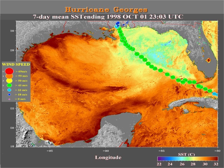
Figure 1 shows SSTs ranging between 25-27°C (77-81°F) several days after the passage of Hurricane Georges in 1998. As Figure 1 illustrates, Georges’ post-storm ‘cold wake’ along and to the right of the superimposed track is 3-5°C (6-9°F) cooler than the undisturbed SST to the west and south (i.e. red/orange regions are ~30°’C [86°’F]). The magnitude and distribution of the cooling pattern shown in this illustration is fairly typical for a post-storm SST analysis.
One important caveat to realize however is that most of the 3-5°C (6-9°F) ocean cooling shown in Figure 1 occurs well after the storm has moved away from the region (in this case several days after Georges made landfall). The amount of ocean cooling that occurs directly beneath the hurricane within the high wind region of the storm is a much more important question scientists would like to have answered. Why? Hurricanes get their energy from the warm ocean water beneath them. However, in order to get a more accurate estimate of just how much energy is being transferred from the sea to the storm, scientists need to know ocean temperature conditions directly beneath the hurricane. Unfortunately, with 150kph+ (100mph+) winds, 20m+ (60ft+) seas and heavy cloud cover being the norm in this region of the storm, direct (or even indirect) measurement of SST conditions within the storm’s “inner core” environment are very rare.
Thankfully in this case “very rare” does not mean “once in a lifetime”. Recently, scientists in AOML’s Hurricane Research Division (HRD) were able to get a better idea of how much SST cooling occurs directly under a hurricane by looking at many storms over a 28 year period. By combining these rare events, HRD scientists put together a “composite average” of ocean cooling directly under the storm.
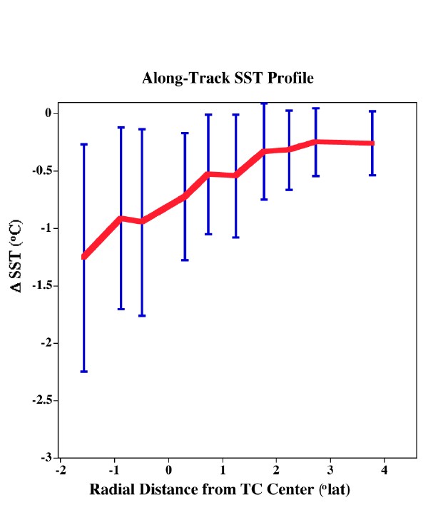
Figure 2 illustrates that, on average, cooling patterns are a lot less than the post storm 3-5°C (6-9°F) cold wake estimates shown in Figure 1. In most cases, the ocean temperature under a hurricane will range somewhere between 0.2 and 1.2°C (0.4 and 2.2°F) cooler that the surrounding ocean environment. Exactly how much depends on many factors including ocean structure beneath the storm (i.e. location), storm speed, time of year and to a lesser extent, storm intensity (Cione and Uhlhorn 2003).
While the estimates in Figure 2 represent a dramatic improvement when it comes to more accurately representing actual SST cooling patterns experienced under a hurricane, even small errors in inner core SST can result in significant miscalculations when it comes to accurately assessing how much energy is transferred from the warm ocean environment directly to the hurricane. With all other factors being equal, being “off” by a mere 0.5°C (1°F) can be the difference between a storm that rapidly intensifies and one that falls apart! With that much at stake, scientists at HRD and other government and academic institutions are working to improve our ability to accurately estimate, observe and predict “under-the-storm” upper ocean conditions. These efforts include statistical studies, modeling efforts and enhanced observational capabilities designed to help scientists better assess upper ocean thermal conditions under the storm. It is believed that future forecasts of tropical cyclone intensity change will be significantly improved.
Reference:
Cione, J. J., and E. W. Uhlhorn, 2003: Sea Surface Temperature Variability in Hurricanes: Implications with Respect to Intensity Change. Monthly Weather Review, 131, 1783-1796.
The Eye is a roughly circular area of fair weather found at the center of a severe tropical storm. The eye is the region of the lowest pressure at the surface and the warmest temperatures at the top. Eye size ranges from 5-120 miles across, but most are 20-40 miles in diameter. Understanding exactly how the eye forms has been controversial. Some scientists believe the radial spreading of the wind creates a warm dry down flow from the upper atmosphere, and this forms the cloud-free eye. Others have think the latent heat release in the eyewall forces the subsidence in the storm center creating the eye.
The Eyewall is a ring of deep convection bordering the eye of the storm. This area has the highest surface winds in the tropical cyclone. Because air in the eye is slowly sinking, it creates an updraft in the eyewall. In particularly strong storms, concentric eyewall circles (or an “eyewall replacement cycle”) can occur. Eyewall replacement happens when a storm reaches its intensity threshold and the eye contracts to a smaller size (5-15 miles). Strong rain bands in the outer storm move inward towards the eye, robbing the inner eyewall of its moisture and momentum and weakening the storm.
Spiral Bands are long, narrow bands of rain and thunderstorms that are oriented in the same direction as the wind movement. They are caused by convection (the vertical movement of air masses) and they spiral into the center of the tropical cyclone. In contrast, the Moat of a storm usually refers to the region between the eyewall and an outer spiral band where rainfall is relatively lighter. Not all hurricanes have moats.
References: Hawkins, H.F., and D.T. Rubsam (1968): “Hurricane Hilda, 1964 : II Structure and budgets of the hurricane on October 1, 1964” Mon. Wea. Rev., 104, pp.418-442
Weatherford, C. and W.M. Gray (1988): “Typhoon structure as revealed by aircraft reconnaissance. Part II: Structural variability” Mon. Wea. Rev., 116, pp.1044-1056
Smith, R.K. (1980): “Tropical Cyclone Eye Dynamics.” J. Atmos. Sci., 37 (6), pp.1227-1232.
Willoughby, H.E. (1979): “Forced secondary circulations in hurricanes” J. Geophys. Res., 84, pp.3173-3183
Shapiro, L.J. and H.E. Willoughby (1982): “The Response of Balanced Hurricanes to Local Sources of Heat and Momentum” J. Atmos. Sci., 39 (2), pp.378-394
Willoughby, H.E. (1990a): “Temporal changes of the primary circulation in tropical cyclones” J. Atmos. Sci., 47, pp.242-264
Willoughby, H.E. (1995): “Mature structure and evolution. Global Perspectives on Tropical Cyclones, R.L. Elsberry (ed.). World Meteorological Organization, Report No. TCP-38; Geneva, Switzerland, 62 pp.
Tropical cyclones tend to be symmetrical. This means the winds should be the same in all quadrants at a given distance from the center. However, most hurricanes are moving, and the storm’s motion will be added to or subtracted from those winds creating an asymmetric structure. The side where the motion is added to the winds is called the “dirty side” as the weather is rougher and more dangerous there.
The “right side” is in reference to the storm’s direction of movement in the Northern Hemisphere. If a hurricane is moving to the west, the right side would be to the north of the storm, if it is heading north, then the right side would be to the east of the storm. In the Southern Hemisphere, this is reversed since a tropical cyclone’s winds spiral around its center clockwise there as opposed to counterclockwise in the Northern Hemisphere. So south of the Equator the “dirty side” is the “left side” of the cyclone.
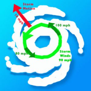
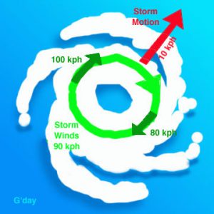
For example, a hurricane with 90mph winds moving at 10mph would have a 100mph wind speed on the forward-moving side and 80 mph on the side with the backward motion. Weather forecast advisories already take this asymmetry into account and, in this case, would state that the highest winds were 100 mph [160 km/hr].
For a tropical cyclone to form, it needs an energy source, typically heat released by convection. Convection describes the process by which warm air rises and expands in the atmosphere, releasing heat and energy that fuels the storm. When the convection is “disorganized,” the heat is scattered and released sporadically throughout the storm, making it difficult for a cyclone to generate the energy necessary to form. In contrast, when convection is “organized,” the heat and energy are focused, persistent, and steady – concentrating the energy and increasing the likelihood of tropical cyclone formation.
The energy released from a hurricane can be explained in two ways: the total amount of energy released by the condensation of water droplets (latent heat), or the amount of kinetic energy generated to maintain the strong, swirling winds of a hurricane. The vast majority of the latent heat released is used to drive the convection of a storm, but the total energy released from condensation is 200 times the world-wide electrical generating capacity, or 6.0 x 10¹⁴ watts per day.
If you measure the total kinetic energy instead, it comes out to about 1.5 x 10¹² watts per day, or ½ of the world-wide electrical generating capacity. It would seem that although wind energy seems to be the most obvious energetic process, it is actually the latent release of heat that feeds a hurricane’s momentum.
To Calculate:
Method 1 – Total energy released through cloud/rain formation: An average hurricane produces 1.5 cm/day (0.6 inches/day) of rain inside a circle of radius 665 km (360 n.mi) (Gray 1981). (More rain falls in the inner portion of hurricane around the eyewall, less in the outer rainbands.) Converting this to a volume of rain gives 2.1 x 1016 cm3/day. A cubic cm of rain weighs 1 gm. Using the latent heat of condensation, this amount of rain produced gives 5.2 x 10¹⁹ Joules/day or 6.0 x 10¹⁴ Watts.
Method 2 – Total kinetic energy (wind energy) generated: For a mature hurricane, the amount of kinetic energy generated is equal to that being dissipated due to friction. The dissipation rate per unit area is air density times the drag coefficient times the wind speed cubed (See Emanuel 1999 for details). One could either integrate a typical wind profile over a range of radii from the hurricane’s center to the outer radius encompassing the storm, or assume an average wind speed for the inner core of the hurricane. Doing the latter and using 40 m/s (90 mph) winds on a scale of radius 60 km (40 n.mi.), gets a wind dissipation rate (wind generation rate) of 1.3 x 10¹⁷ Joules/day (1.5 x 10¹²Watts).
Reference: Emanuel, K. A., (1999): “The power of a hurricane: An example of reckless driving on the information superhighway” Weather, 54, 107-108
There are no other planets known to have warm water oceans from which true water cloud hurricanes can form. However, many astronomers and planetary meteorologists believe gas giant planets such as Jupiter and Saturn exhibit similar storms. The principal candidate is the famous Great Red Spot (GRS) on Jupiter, and the numerous whorls that surround it, where ammonia takes the place of water. The GRS exhibits an anticyclonic circulation at its top, just as tropical cyclones do at the top of the troposphere. On Saturn, a polar storm has been spotted by the Cassini spacecraft measuring up to 1,250 miles in diameter, about 20 time larger than an Earthly hurricane with winds four times stronger. On Mars, a large, cyclonic cloud feature forms every year in the northern hemisphere. It forms in the morning and dissipates by the afternoon. This cloud is likely composed of water/ice and is white in appearance. It doesn’t appear to rotate but is about 1000 miles wide with an inner hole or ‘eye’ about 200 miles across.
Over 3,400 extrasolar planets have been found to date, but no others are confirmed to have convectively driven storms. However, there is reason to believe such storms exist on extrasolar planets as well.
The Atlantic hurricane season is June 1st to November 30th. In the East Pacific, it runs from May 15th to November 30th. Hurricane Awareness week runs from May 25th through May 31st and is a great time to get your hurricane kit and plans up to date.
NOAA’s seasonal outlook is released in late May and revised in early August. You can find the latest version here: NOAA Seasonal Outlook
Hurricanes have occurred outside of the official six month season , but these dates were selected to encompass the majority of Atlantic tropical cyclone activity (over 97%). When the Weather Bureau organized its new hurricane warning network in 1935 it scheduled a special telegraph line to connect the various centers to run from June 15th through November 15th. Those remained the start and end dates of the ‘official’ season until 1964, when it was decided to end the season on November 30th, and in 1965, when the start was moved to the beginning of June. These changes made the Atlantic hurricane season six months long and easier for people to remember.
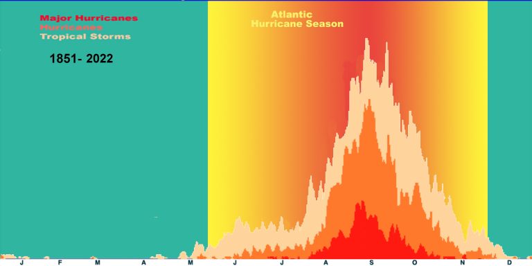
Atlantic Ocean tropical cyclone activity over a year
The Atlantic basin shows a very peaked season from August through October, with 78% of the tropical storm days, 87% of the minor hurricane days, and 96% of the major hurricane days occurring then (Landsea (NHC) 1993). Maximum activity occurs in early to mid September. “Out of season” tropical cyclones primarily occur in May or December.
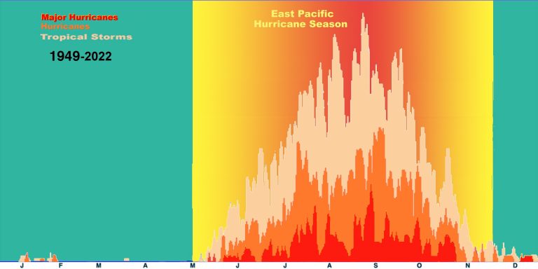
East Pacific Ocean tropical cyclone activity over a year
The Northeast Pacific basin has a broader peak with activity beginning in late May or early June and going until late October or early November with a peak in storminess in late August/early September. The National Hurricane Center’s official dates for this basin are from May 15th to November 30th.
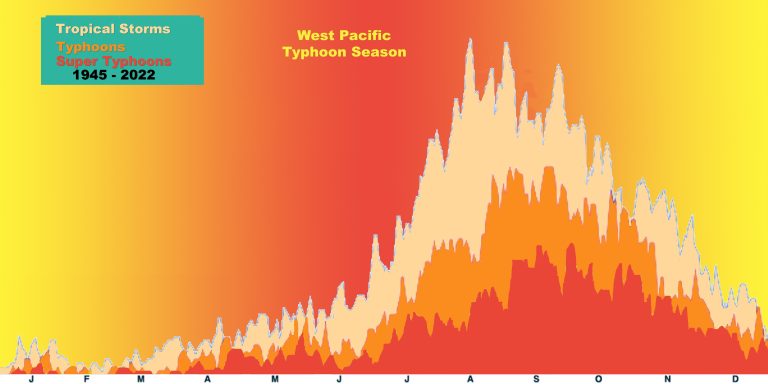 West Pacific Ocean tropical cyclone activity over a year
The Northwest Pacific basin has tropical cyclones occurring all year round regularly. There is no official definition of typhoon season for this reason. There is a distinct minimum in February and the first half of March, and the main season goes from July to November with a peak in late August/early September.
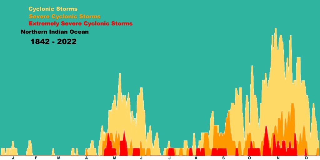
The North Indian basin has a double peak of activity in May and November though tropical cyclones are seen from April to December. The severe cyclonic storms (>33 m/s winds [76 mph]) occur almost exclusively from April to June and late September to early December.
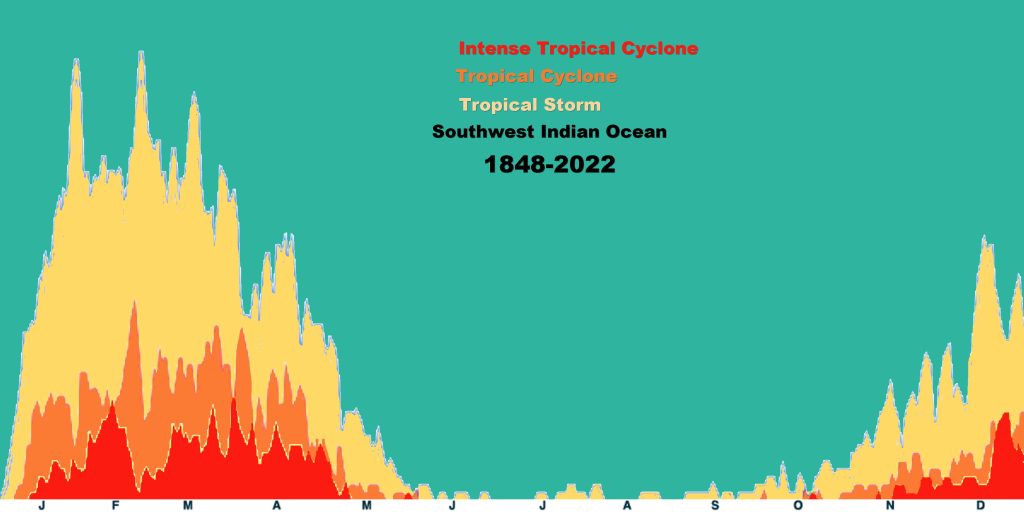
The Southwest Indian and Australian/Southeast Indian basins have very similar annual cycles with tropical cyclones beginning in late October/early November, reaching a peak in activity from mid-January to early May. The Australian/Southeast Indian basin February lull in activity is a bit more pronounced than the Southwest Indian basin’s lull.
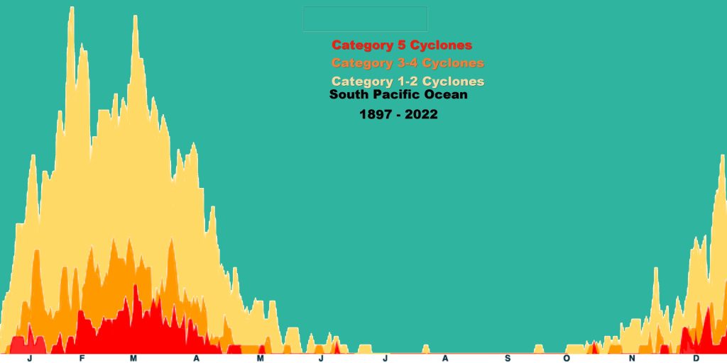
The Australian/Southwest Pacific basin begin with tropical cyclone activity in late October/early November, reaches a single peak in March, and then fades out in early May.
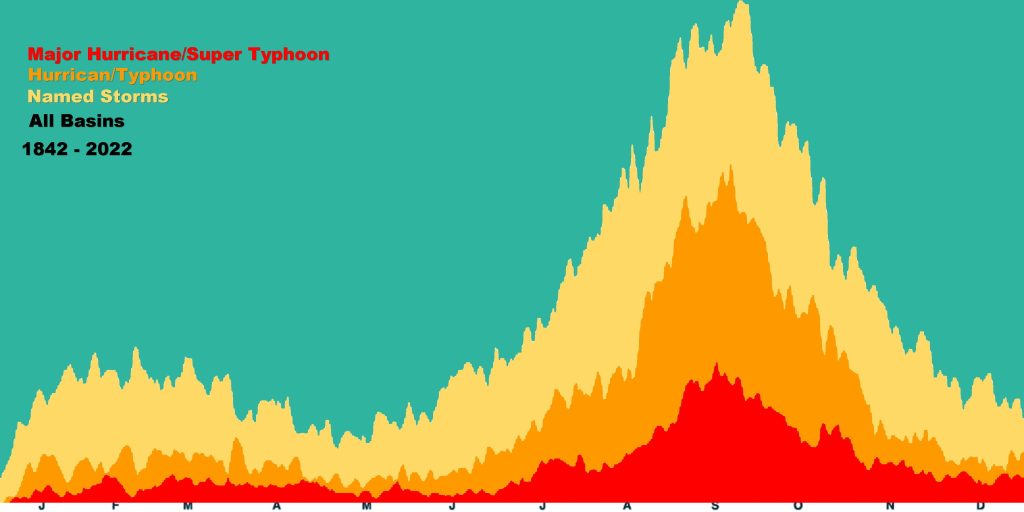
Globally, September is the most active month and May is the least active month. (Neumann 1993)
References: Neumann, C.J., B.R. Jarvinen, C.J. McAdie, and J.D. Elms (1993): Tropical Cyclones of the North Atlantic Ocean, 1871-1992, Prepared by the National Climatic Data Center, Asheville, NC, in cooperation with the NHC, Coral Gables, FL, 193pp.
The best time to prepare is before hurricane season begins. Make a plan for you and your family about what to do if a hurricane threatens. Put together a hurricane kit. Ensure your house is up to code, and check for problems, such as overhanging branches or missing roof tiles. Check your shutters and other window and door coverings. Once the season begins, stay informed. Check the outlook every day, and if anything is threatening keep updated on the latest advisories.
For hurricane preparation tips, check out FEMA’s comprehensive downloadable guidebook and visit www.ready.gov/hurricanes for the best information available on hurricane preparedness.
Don’t forget to sign up for wireless emergency alerts. Alternatively, you can get updates from NOAA Radio or Radio Fax (for mariners).
The mean annual damage from hurricanes in the US is 9.5 billion dollars, when we adjust not only for inflation but for the increase in value of real goods in average households. Hurricane damage varies greatly from year to year, depending on the number and strength of hurricanes making landfall, but there does not seem to be a long-term trend in adjusted damage over the last century.
There is very little association between the physical size of a hurricane and its intensity. A big hurricane does not have to be an intense one and vice versa. The damage a hurricane can cause is a function of both its maximum sustained wind and the extent of the hurricane force winds. A broad, weak storm may cause as much damage as a small, strong one.
It is false to think that damage is linear with wind speed, that a 150-mph winds will cause twice the damage as a 75-mph winds. The relationship is exponential, and not linear. A category 5 storm could cause up to 250 times the damage of a category 1 hurricane of the same size.
| Intensity | Cases | Median Damage | Potential Damage * |
| Tropical/Subtropical Storm | 118 | < $1,000,000 | 0 |
| Hurricane Category 1 | 45 | $33,000,000 | 1 |
| Hurricane Category 2 | 29 | $336,000,000 | 10 |
| Hurricane Category 3 | 40 | $1,412,000,000 | 50 |
| Hurricane Category 4 | 10 | $8,224,000,000 | 250 |
| Hurricane Category 5 | 2 | $5,973,000,000 | 500 |
Mean annual damage in mainland US is $4,900,000,000.
The worst U.S. hurricane damage – after normalizing to today’s population, wealth and dollars – is no longer Hurricane Andrew, but is instead the 1926 Great Miami Hurricane. If this storm hit in the mid-1990s, it is estimated that it would cause over $70 billion in South Florida and then an additional $10 billion in the Florida panhandle and Alabama.
The United States has at least a 1 in 6 chance of experiencing losses related to hurricanes of at least $10 billion on average.
Even though the major hurricanes (the category 3, 4 and 5 storms) comprise only 21% of all US landfalling tropical cyclones, they account for 83% of all of the damage.
Damages have not been on the increase once one normalizes for inflation, wealth, and coastal population changes. Instead one sees that hurricane damages that were fairly low during the first two decades of the 20th Century, are quite high in the 1920s and 1940s to 1960s, and substantially lower in the 1970s and 1980s. Only during the early 1990s does damage approach the high level of impacts seen back in the 1940s through the 1960s. Thus recent hurricane damages are not unprecedented.
References: Weatherford, C. and W.M. Gray (1988): “Typhoon structure as revealed by aircraft reconnaissance. Part II: Structural variability” Mon. Wea. Rev., 116, pp.1044-1056
Pielke, Jr. R. A., and C. W. Landsea, 1998: “Normalized Atlantic hurricane damage 1925-1995” Wea. Forecasting, 13, pp.621-631
Just as every person is an individual, every hurricane is different. So every experience with such a storm will be unique. The summary below is of a general sequence of events one might expect from a Category 2 hurricane approaching a coastal area. What you might experience could be vastly different.
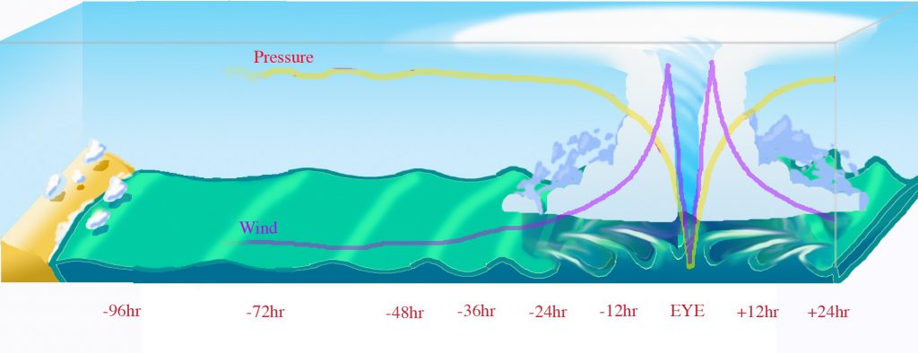
- 96 hours before landfall
At first there aren’t any apparent signs of a storm. The barometer is steady, winds are light and variable, and fair weather cumulus clouds dot the sky. But the perceptive observer will note a swell on the ocean surface of about a meter (3 feet) in height with a wave coming ashore every ten seconds. These waves race out far ahead of a storm at sea, but could easily be masked by locally wind driven waves. - 72 hours before landfall
Little has changed, except that the swell has increased to about 2 meters (6 feet) in height and the waves now come in every nine seconds. This means that the storm, still far over the horizon, is approaching. - 48 hours before landfall
If anything, conditions have improved. The sky is now clear of clouds, the barometer is steady, and the wind is almost calm. The swell is now about 3 m (9 feet) and coming in every 8 seconds. A hurricane watch is issued, and areas with long evacuation times are given the order to begin. - 36 hours before landfall
The first signs of the storm appear. The barometer is falling slightly, the wind is around 5 m/s (10 kts, 11 mph), and the ocean swell is about 4m (13 feet) in height and coming in 7 seconds apart. On the horizon a large mass of white cirrus clouds appear. As the veil of clouds approaches it covers more of the horizon. A hurricane warning is issued and low lying areas and people living in mobile homes are ordered to evacuate. - 30 hours before landfall
The sky is now covered by a high overcast. The barometer is falling at .1 millibar per hour (.003 inches of Hg/hr), and the winds pick up to about 10 m/s (20 kts, 23 mph). The ocean swell, coming in only 5 seconds apart, is beginning to be obscured by wind driven waves, and small whitecaps begin to appear on the ocean surface. - 24 hours before landfall
In addition to the overcast, small low clouds streak by overhead. The barometer is falling by .2 mb/hr (.006″Hg/hr), the wind picks up to 15 m/s (30 kts, 34 mph). The wind driven waves are covered in whitecaps and streaks of foam begin to ride over the surface. Evacuations should be completed and final preparations made by this time. - 18 hours before landfall
The low clouds are thicker and bring driving rain squalls with gusty winds. The barometer is steadily falling at half a millibar per hour (.015 “Hg/hr), and the winds are whistling by at 20 m/s (40 kts, 46 mph). It is hard to stand against the wind. - 12 hours before landfall
The rain squalls are more frequent and the winds don’t diminish after they depart. The cloud ceiling is getting lower, and the barometer is falling at 1 mb/hr (.029 “Hg/hr). The wind is howling at hurricane force at 32 m/s (64 kts, 74 mph), and small, loose objects are flying through the air and branches are stripped from trees. The sea advances with every storm wave that crashes ashore and the surface is covered with white streaks and foam patches. - 6 hours before landfall
The rain is constant now and the 40 m/s wind (80 kts, 92 mph) drives it horizontally. The barometer is falling 1.5 mb/hr (.044 “Hg/hr), and the storm surge has advanced above the high tide mark. It is impossible to stand upright outside without bracing yourself, and heavy objects like coconuts and plywood sheets become airborne missiles. The wave tops are cut off and make the sea surface a whitish mass of spray. - 1 hour before landfall
It didn’t seem possible, but the rain has become heavier, a torrential downpour. Low areas inland become flooded from the rain. The winds are roaring at 45 m/s (90 kts, 104 mph), and the barometer is free-falling at 2 mb/hr (.058 “Hg/hr). The sea is white with foam and streaks. The storm surge has covered coastal roads and 5 meter (16 foot) waves crash into buildings near the shore. - The eye
Just as the storm reaches its peak, the winds begin to slacken, and the sky starts to brighten. The rain ends abruptly and the clouds break and blue sky is seen. However the barometer continues falling at 3 mb/hr (.09 “Hg/hr) and the storm surge reaches the furthest inland. Wild waves crash into anything in the grasp of the surge. Soon the winds fall to near calm, but the air is uncomfortably warm and humid. Looking up you can see huge walls of cloud on every side, brilliant white in the sunlight.
At this point, the barometer stops falling and in a moment begins to rise, soon as fast as it fell. The winds begin to pick up slightly and the clouds on the far side of the eyewall loom overhead. - 1 hour after landfall
The sky darkens and the winds and rain return just a heavy as they were before the eye. The storm surge begins a slow retreat, but the monstrous waves continue to crash ashore. The barometer is now rising at 2 mb/hr (.058 “Hg/hr). The winds top out at 45 m/s (90 kts, 104 mph), and heavy items torn loose by the front side of the storm are thrown about and into sides of buildings that had been in the lee before the eye passed. - 6 hours after landfall
The flooding rains continue, but the winds have diminished to a ‘mere’ 40 m/s (80 kts, 92 mph). The storm surge is retreating and pulling debris out to sea or stranding sea borne objects well inland. It is still impossible to go outside. - 12 hours after landfall
The rain now comes in squalls and the winds begin to diminish after each squall passes. The cloud ceiling is rising, as is the barometer at 1 mb/hr (.029 “Hg/hr). The wind is still howling at near hurricane force at 30 m/s (60 kts, 69 mph), and the ocean is covered with streaks and foam patches. The sea level returns to the high tide mark. - 24 hours after landfall
The low clouds break into smaller fragments and the high overcast is seen again. The barometer is rising by .2 mb/hr (.006″Hg/hr), the wind falls to 15 m/s (30 kts, 34 mph). The surge has fully retreated from land, but the ocean surface is still covered by small whitecaps and large waves. - 36 hours after landfall
The overcast has broken and the large mass of white cirrus clouds disappears over the horizon. The sky is clear and the sun seems brilliant. The barometer is rising slightly, the wind are a steady 5 m/s (10 kts, 11 mph). All around are torn trees and battered buildings. The air stinks of dead vegetation and muck that was dredged by the storm from the bottom of the sea to cover the shore. The all clear is given.
Last updated August 13, 2004
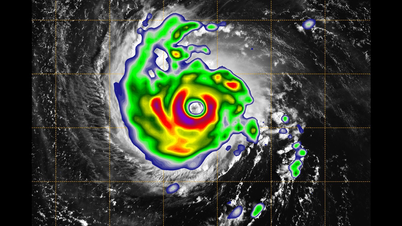
Hurricane forecasters estimate tropical cyclone strength from satellite using a method called the Dvorak technique. Vern Dvorak developed the scheme in the early 1970s using a pattern recognition decision tree (Dvorak 1975, 1984). Utilizing the current satellite picture of a tropical cyclone, one matches the image versus a number of possible pattern types: Curved band Pattern, Shear Pattern, Eye Pattern, Central Dense Overcast (CDO) Pattern, Embedded Center Pattern or Central Cold Cover Pattern. If infrared satellite imagery is available for Eye Patterns (generally the pattern seen for hurricanes, severe tropical cyclones and typhoons), then the scheme utilizes the difference between the temperature of the warm eye and the surrounding cold cloud tops. The larger the difference, the more intense the tropical cyclone is estimated to be.
From this one gets a “T-number” and a “Current Intensity (CI) Number”. CI numbers have been calibrated against aircraft measurements of tropical cyclones in the Northwest Pacific and Atlantic basins. On average, the CI numbers correspond to the following intensities:
| CI Number | Maximum Sustained One Minute Winds (kts) |
Central Pressure (mb) |
|
| Atlantic | NW Pacific | ||
| 0.0 | <25 | —- | —- |
| 0.5 | 25 | —- | —- |
| 1.0 | 25 | —- | —- |
| 1.5 | 25 | —- | —- |
| 2.0 | 30 | 1009 | 1000 |
| 2.5 | 35 | 1005 | 997 |
| 3.0 | 45 | 1000 | 991 |
| 3.5 | 55 | 994 | 984 |
| 4.0 | 65 | 987 | 976 |
| 4.5 | 77 | 979 | 966 |
| 5.0 | 90 | 970 | 954 |
| 5.5 | 102 | 960 | 941 |
| 6.0 | 115 | 948 | 927 |
| 6.5 | 127 | 935 | 914 |
| 7.0 | 140 | 921 | 898 |
| 7.5 | 155 | 906 | 879 |
| 8.0 | 170 | 890 | 858 |
Note that this estimation of both maximum winds and central pressure assumes that the winds and pressures are always consistent. However, since the winds are really determined by the pressure gradient, small tropical cyclones (like the Atlantic’s Andrew in 1992, for example) can have stronger winds for a given central pressure than a larger tropical cyclone with the same central pressure. Thus caution is urged in not blindly forcing tropical cyclones to “fit” the above pressure- wind relationships. (The reason that lower pressures are given to the Northwest Pacific tropical cyclones in comparison to the higher pressures of the Atlantic basin tropical cyclones is because of the difference in the background climatology. The Northwest Pacific basin has a lower background sea level pressure field. Thus to sustain a given pressure gradient and thus the winds, the central pressure must accordingly be smaller in this basin.)
The errors for using the above Dvorak technique in comparison to aircraft measurements taken in the Northwest Pacific average 10 mb with a standard deviation of 9 mb (Martin and Gray 1993). Atlantic tropical cyclone estimates likely have similar errors. Thus an Atlantic hurricane that is given a CI number of 4.5 (winds of 77 kt and pressure of 979 mb) could in reality be anywhere from winds of 60 to 90 kt and pressures of 989 to 969 mb. These would be typical ranges to be expected; errors could be worse. However, in the absence of other observations, the Dvorak technique does at least provide a consistent estimate of what the true intensity is.
While the Dvorak technique was calibrated for the Atlantic and Northwest Pacific basin because of the aircraft reconnaissance data ground truth, the technique has also been quite useful in other basins that have limited observational platforms. However, at some point it would be preferable to re-derive the Dvorak technique to calibrate tropical cyclones with available data in the other basins.
Lastly, while the Dvorak technique is primarily designed to provide estimates of the current intensity of the storm, a 24 h forecast of the intensity can be obtained also by extrapolating the trend of the CI number. Whether this methodology provides skillful forecasts is unknown.
References: Dvorak, V.F., 1975: “Tropical cyclone intensity analysis and forecasting from satellite imagery” Mon. Wea. Rev., 103, pp.420-430
Dvorak, V.F., 1984: “Tropical cyclone intensity analysis using satellite data” NOAA Tech. Rep. NESDIS 11, 47pp
Fitzpatrick, P.J., J.A. Knaff, C.W. Landsea, and S.V. Finley (1995): “A systematic bias in the Aviation model’s forecast of the Atlantic tropical upper tropospheric trough: Implications for tropical cyclone forecasting” Wea. Forecasting, 10, pp.433-446
Martin, J.D., and W.M. Gray (1993): “Tropical cyclone observation and forecasting with and without aircraft reconnaissance” Wea. Forecasting, 8, pp.519-532
Observations & Measurements
There are several methods used by NOAA, the United States Geological Survey (USGS), and the Federal Emergency Management Agency (FEMA) to measure storm surge. Each method has advantages and draw backs. Post-storm analysis of storm surge requires resolving differences in what each measures in order to find the best approximation of the surge heights.
Tide Stations (NOAA)
Check your coastal marine forecast at NOAA’s Tides & Currents Website.
A network of 175 long-term, continuously operating water level stations located throughout the U.S. serving as the foundation for NOAA’s tide prediction products.
Measures still water (e.g. no waves)
Traditionally the most reliable method
Limited, fixed stations
High Water Marks (USGS / FEMA)
These are the lines left on trees and structures marking the highest (peak) elevation of the water surface from a flood event. They are created by foam, seeds, and other debris. Survey crews deploy after a storm, locate, and record reliable high-water marks. GPS methods are used to determine the location of these marks, which are then mapped relative to a vertical reference datum.
Perishable
Traditionally best method for capturing highest surge level
Subjective and often includes impact of waves
Pressure Sensors (USGS)
These are temporary water-level and barometric-pressure sensors which provide information about storm surge duration, times of surge arrival and retreat, and maximum depths.
Relatively new method
Mobile, deployed in advance of storms at expected location of highest surge
Can contain impact of waves
Forecasting
The Sea, Lake, and Overland Surges from Hurricanes (SLOSH) model is the computer model utilized by the National Oceanic and Atmospheric Administration (NOAA) for coastal inundation risk assessment and the operational prediction of storm surge.
The eastern seaboard and Gulf Coast of the United States, Puerto Rico, the Bahamas, the Virgin Islands, and Hawaii, are subdivided into 39 regions or “basins.” These areas represent sections of the coastline that are centered upon particularly susceptible features: inlets, large coastal centers of population, low-lying topography, and ports. The SLOSH model computes the maximum potential impact of the storm in these “computational domains” based on storm intensity, track, and estimates of storm size provided by hurricane specialists at the National Hurricane Center.
The National Center for Environmental Prediction (NCEP) is the part of NOAA that handles forecasting the weather. The National Hurricane Center (NHC) is the division of NCEP that monitors and forecasts tropical cyclones in the North Atlantic, the East Pacific, and the Central Pacific out to 180°W. For other parts of the world see the map above for other tropical cyclone prediction centers and their jurisdictions.
NHC issues an official forecast for any tropical cyclone in its area of responsibility every six hours, which includes the center position, maximum one-minute surface (10 meter [33 ft] elevation) wind speed (intensity), and radii of the 34 knot (39 mph,63 kph), 50 knot (58 mph,92 kph), and 64 knot (74 mph,117 kph) wind speeds in four quadrants (northeast, southeast, southwest, and northwest) surrounding the cyclone.
NHC’s Track and Intensity forecasts have both improved substantially over the years and continue to improve. Today a 3-day forecast is as accurate as those issued for a 2-day prediction in the late 1980s. However, much work still remains to better understand and predict wind intensity changes in tropical storms and hurricanes.
Read more at the National Hurricane Center’s Forecast Accuracy Page.
These official forecasts are later verified and then consolidated into a “best track” for the storm. The Best Track has a center position and maximum wind speed value for each six-hour time that represents the official NHC estimate of the location and intensity of a tropical cyclone. Values of central pressure and the radii of hurricane-force and gale-force winds may also be included as well as other significant events, such as landfall or peak intensity, especially if they occur other than the six-hourly times.
The Best Tracks are included in the Tropical Cyclone Reports issued by NHC after hurricane season. They are also included in the official hurricane database HURDAT2.
The National Hurricane Center has a great Glossary of Terms that are used in weather forecasts. Some important terms from that glossary are below.
Hurricane Watch – A Hurricane Watch is an announcement that hurricane force winds are possible within the specified area in association with a tropical cyclone. A hurricane watch is issued 48 hours in advance of the anticipated onset.
Hurricane Warning – Hurricane warnings are issued 36 hours in advance and are announced when hurricane force winds are expected somewhere within the specified area in association with a cyclone. This warning can remain in effect in the face of other hazards, such as flooding even if the winds drop to below hurricane force.
Advisory – An advisory contains all tropical cyclone watches and warnings in effect along with details concerning tropical cyclone locations, intensity and movement, and precautions to be taken.
Maximum sustained wind – This is determined as winds that last for an average of at least one minute at the surface of a hurricane or about 33 feet (10 meters).
Gusts – are classified as a 3-5 second burst of wind higher than the maximum sustained wind.
Storm Surge Watch – A storm surge watch is the possibility of a life-threatening inundation from rising water moving inland from the shoreline, and it is usually issued 48 hours from the anticipated event in association with an ongoing tropical storm.
Storm Surge Warning – The danger of a life-threatening inundations from rising water moving inland, and usually issued 36 hours in advance of the event in association with an ongoing tropical storm.
Storm Track – A storm track is a representation of a tropical cyclone’s predicted path, location, and intensity over its lifetime. The best track contains the cyclone’s latitude, longitude, maximum sustained winds, and minimum sea level pressure at 6-hour intervals.
Storm Intensity – Hurricane intensity refers to the amount of energy a hurricane is carrying with it. Hurricane intensity and size are not closely related.
Reference: Powell, M.D., S.H. Houston, and T.A. Reinhold, 1996:”Hurricane Andrew’s Landfall in South Florida, Part I: Standardizing measurements for documentation of surface wind fields.” Wea. Forecast. v.11, p.329-349
The Atlantic Oceanographic and Meteorological Laboratory (AOML) supports these organizations by doing hurricane research with both observations and model experiments in order to provide guidance and integrate new technology into the forecast models. These experimental models are tested rigorously and submitted to the NCEP for verification before they are integrated into the operational models and sent to the NHC for use in the public forecast.
There are a number of different seasonal forecasts currently being issued by different organizations for various basins. Some of these are fairly new, while the oldest and most well known (Prof. Bill Gray’s forecast from Colorado State [CSU]) has been issued for over four decades. Over the last twenty years, seasonal forescasts have been issued by the National Oceanic and Atmospheric Administration (NOAA), and Tropical Storm Risk (TSR).
Click here for a comparison of the CSU, NOAA, and TSR seasonal outlook numbers.
North Atlantic Basin:
- Dr. Klotzbach, Department of Atmospheric Science, Colorado State University
- National Oceanic and Atmospheric Administration, CPC/AOML/NHC Team – Forecast Archive
- Maritza Ballester, Cuban Institute of Meteorology
- Mark Saunders, Tropical Storm Risk, Department of Space and Climate Physics, University College London
- Florida State University COAPS
- International Research Institute for Climate and Society; Columbia University
- European Centre for Medium Range Weather Forecasts; Reading, England
NE Pacific Basin:
- National Oceanic and Atmospheric Administration, CPC/AOML/NHC Team
- European Centre for Medium Range Weather Forecasts; Reading, England
- National Meteorological Service; Mexico City, Mexico
- International Research Institute for Climate and Society; Columbia University
NW Pacific Basin:
- Mark Saunders, Tropical Storm Risk, Department of Space and Climate Physics, University College London
- Prof. Johnny C. L. Chan, Laboratory for Atmospheric Research, Dept. of Physics & Mat. Sci., City University of Hong Kong
- National Climate Centre, PRC
- European Centre for Medium Range Weather Forecasts; Reading, England
- International Research Institute for Climate and Society; Columbia University
Australian Basin:
- Mark Saunders, Tropical Storm Risk, Department of Space and Climate Physics, University College London
- International Research Institute for Climate and Society; Columbia University
- European Centre for Medium Range Weather Forecasts; Reading, England
- Macquarie University, Sydney, Australia
South China Sea:
South Pacific Basin:
- International Research Institute for Climate and Society; Columbia University
- European Centre for Medium Range Weather Forecasts; Reading, England
- Macquarie University, Sydney, Australia
The major hurricane track forecast models run operationally for the Atlantic, Eastern Pacific, and Central Pacific hurricane basins are:
- The basic model that is used as a “no-skill” forecast to compare other models against is CLIPER (CLImatology and PERsistence), which is a multiple regression statistical model that best utilizes the persistence of the current motion and also incorporates a climatological track information (Aberson 1998). Surprisingly, CLIPER was difficult to beat with numerical model forecasts until the 1980s.
- The Trajectory And Beta (TAB) models are a series of simple barotropic models run over a shallow (S), medium (M), and deep (D) layer. These replace the earlier Beta Advection Models (BAM).
- The NOAA Global Forecast System (GFS), formerly known as the Aviation and MRF models (Lord 1993) has been used for track forecasting since the 1992 hurricane season. An ensemble of lower-resolution runs is available four times daily. Current information on the GFS
- A doubly-nested movable mesh primitive equation non-hydrostatic model known as HWRF (for the Hurricane Weather Research and Forecast Model), has provided forecasts since 2006. It uses GFS fields for boundary conditions (Gopal et al 2012). Current information on HWRF
- Hurricanes in a Multi-scale Ocean-coupled Non-hydrostatic Model (HMON) is one of the two on-demand hurricane forecast systems run at NCEP. HMON uses the Non-hydrostatic Multi-scale Model on a B grid (NMMB) dynamic core. It includes vortex relocation, but has no data assimilation. Current information on HMON.
- The United Kingdom Meteorological Office’s global UKMET (or Unified Model) model is utilized for forecasting the tracks of tropical cyclones around the world (Radford 1994). NHC starting receiving these operationally in 1996. Current information on the Unified Model
- The United States Navy Global Environmental Model (NAVGEM) is also a global numerical model that shows skill in forecasting tropical cyclone track (Fiorino et al. 1993). This model was also first received operationally at the National Hurricane Center during 1996. An ensemble of lower-resolution runs is available twice daily.
- The Canadian Meteorological Center’s Global Environmental Multi-scale Model (GEM) provides forecasts twice per day. An ensemble of lower-resolution runs is available twice daily. Current information on GEM
- The European Centre for Medium-Range Weather Forecast’s (ECMWF) system provides forecasts twice per day. It has proven to be the best model for track forecasting, and is the highest resolution global model available. An ensemble of lower-resolution runs is available twice daily.
- The Japanese Meteorological Agency’s Global Spectral Model (GSM) provides forecasts, both in high-resolution deterministic runs and lower-resolution ensemble runs. Current information on the GSM
The full list of models used in the Atlantic and Eastern and Central Pacific is available to download here. Various types of consensus models (ensemble means) are available from these models.
Despite the variety of hurricane track forecast models, there are only a few models that provide operational intensity change forecasts for the Atlantic and Eastern and Central Pacific basins:
- Similar to the CLIPER track model, the SHIFOR (Statistical Hurricane Intensity Forecast model) is used as a “no-skill” intensity change forecast. It is a multiple regression statistical model that best utilizes the persistence of the intensity trends and also incorporates climatological intensity change information (Jarvinen and Neumann 1979). SHIFOR has been difficult to exceed until recent years.
- A statistical-synoptic model, SHIPS (Statistical Hurricane Intensity Prediction Scheme), has been available since the mid-1990s (DeMaria and Kaplan 1994). It takes current and forecasted information on the synoptic scale on the sea surface temperatures, vertical shear, moist stability, etc. with an optimal combination of the trends in the cyclone intensity.
- A statistical scheme for estimating the probability of rapid intensification has been developed (Kaplan et al 2010) and is now being used operationally. The RI scheme employs synoptic and persistence information from the SHIPS model to estimate the probability of rapid intensification (24 h increase in maximum wind of 35 mph or greater) every 6 hours.
- The Logistic Growth Equation Model (LGEM) uses the same inputs as the SHIPS model but uses a dynamical scheme. The intensity is determined by a logistic growth equation constrained by the maximum potential intensity as derived from the sea surface temperature. LGEM differs from SHIPS in that it accounts for changes in environmental conditions rather than using values averaged over the forecast period.
- The HWRF model, described above in the track forecasting models, also issue forecasts of intensity change.
- HAFS is NOAA’s Hurricane Analysis and Forecast System, a storm-centric version similar to NOAA’s Global Forecast System that uses high-resolution moving nests (Ramstrom et al. 2024). This model has been operational since 2023. There are two versions, HAFS-A (which runs for all global basins) and HAFS-B (which runs for the Atlantic and East Pacific). HAFS-B also uses TC-specific modifications to the boundary layer physics to help improve structure and intensity forecasts (Chen et al. 2023, Hazelton et al. 2024).
Information on the performance of these models is available after each season here. And the yearly reports on model verification are here.
References: Aberson, Sim D. (1998): “Five-day tropical cyclone track forecasts in the North Atlantic basin” Weather and Forecasting, 13, pp.1005-1015
Marks, D.G. (1992): “The beta and advection model for hurricane track forecasting” NOAA Tech. Memo. NWS NMC 70, Natl. Meteorological Center; Camp Springs, Maryland, 89 pp.
Lord, S.J. (1993): “Recent developments in tropical cyclone track forecasting with the NMC global analysis and forecast system” Preprints of the 20th Conference on Hurricanes and Tropical Meteorology, San Antonio, Amer. Meteor. Soc., pp.290-291
Bender, M.A., R.J. Ross, R.E. Tuleya, and Y. Kurihara (1993): “Improvements in tropical cyclone track and intensity forecasts using the GFDL initialization system” Mon. Wea. Rev., 121, pp.2046-2061
Gopalakrishnan, S.G., S. Goldenberg, T. Quirino, X. Zhang, F. Marks, K-S Yeh, R. Atlas, V. Tallapragada (2012): “Toward Improving High-Resolution Numerical Hurricane Forecasting: Influence of Model Horizontal Grid Resolution, Initialization, and Physics” Wea. Forecasting, 27, pp.647-666.
Radford, A.M. (1994): “Forecasting the movement of tropical cyclones at the Met. Office” Met. Apps., 1, pp.355-363
Fiorino, M., J.S. Goerss, J.J. Jensen, E.J. Harrison, Jr.(1993): “An evaluation of the real-time tropical cyclone forecast skill of the Navy operations global atmospheric prediction system in the western North Pacific” Wea. Forecasting, 8, pp.3-24
Jarvinen, B.R., and C.J. Neumann (1979): “Statistical forecast of tropical cyclone intensity” NOAA Tech. Memo. NS NHC-10, 22pp.
DeMaria, M. and J. Kaplan (1994): “A statistical hurricane intensity prediction scheme (SHIPS) for the Atlantic basin” Wea. Forecasting, 9, pp.209-220
The Dvorak technique is a method used to estimate the intensity of a tropical cyclone based on satellite imagery. Developed by Vernon Dvorak in the 1970s, it analyzes cloud patterns associated with tropical storms. After a cloud pattern has been analyzed, meteorologists compare the imagery to a set of standard patterns, which have associated wind speeds and pressure values. By analyzing how closely the imagery matches the patterns, scientists can obtain a T-number (Tropical Number), which is a numerical value that corresponds to the intensity of the storm. Higher T-numbers indicate stronger storms.
This T-number is converted to a Current Intensity (CI) number using a set of standardized tables. This CI number corresponds to a specific range of winds and pressures, giving meteorologists a method to interpolate the intensity of the cyclone from satellite imagery.
An advanced version of the Dvorak technique is widely used by meteorologists and weather agencies because it allows for the continuous monitoring of tropical cyclones, even when direct measurements from aircraft reconnaissance are not available. It plays a crucial role in forecasting and assessing the potential impact of these storms.
The U.S. Government once supported research into methods of hurricane modification, known as Project STORMFURY.
It was an ambitious experimental program of research on hurricane modification carried out between 1962 and 1983. The proposed modification technique involved artificial stimulation of convection outside the eyewall through seeding with silver iodide. The invigorated convection, it was argued, would compete with the original eyewall, lead to the reformation of the eyewall at larger radius, and thus, through partial conservation of angular momentum, produce a decrease in the strongest winds.
Since a hurricane’s destructive potential increases rapidly as its strongest winds become stronger, a reduction as small as 10% would have been worthwhile. Modification was attempted in four hurricanes on eight different days. On four of these days, the winds decreased by between 10 and 30%, The lack of response on the other days was interpreted to be the result of faulty execution of the seeding or of poorly selected subjects.
These promising results came into question in the mid-1980s because observations in unmodified hurricanes indicated:
- That cloud seeding had little prospect of success because hurricanes contained too much natural ice and too little supercooled water.
- That the positive results inferred from the seeding experiments in the 1960s stemmed from inability to discriminate between the expected results of human intervention and the natural behavior of hurricanes.
For a couple decades NOAA and its predecessor tried to weaken hurricanes by dropping silver iodide – a substance that serves as an effective ice nuclei – into the rainbands of the storms. During the STORMFURY years, scientists seeded clouds in Hurricanes Esther (1961), Beulah (1963), Debbie (1969), and Ginger (1971). The experiments took place over the open Atlantic far from land. The STORMFURY seeding targeted convective clouds just outside the hurricane’s eyewall in an attempt to form a new ring of clouds that, hopefully, would compete with the natural circulation of the storm and weaken it. The idea was that the silver iodide would enhance the thunderstorms of a rainband by causing the supercooled water to freeze, thus liberating the latent heat of fusion and helping a rainband to grow at the expense of the eyewall. With a weakened convergence to the eyewall, the strong inner core winds would also weaken quite a bit. For cloud seeding to be successful, the clouds must contain sufficient supercooled water (water that has remained liquid at temperatures below the freezing point, 0°C/32°F). Neat idea, but in the end it had a fatal flaw. Observations made in the 1980s showed that most hurricanes don’t have enough supercooled water for STORMFURY seeding to work – the buoyancy in hurricane convection is fairly small and the updrafts correspondingly small compared to the type one would observe in mid-latitude continental super or multicells.
In addition, it was found that unseeded hurricanes form natural outer eyewalls just as the STORMFURY scientists expected seeded ones to do. This phenomenon makes it almost impossible to separate the effect (if any) of seeding from natural changes. The few times that they did seed and saw a reduction in intensity was undoubtedly due to what is now called “concentric eyewall cycles.” Thus nature accomplishes what NOAA had hoped to do artificially. No wonder the first few experiments were thought to be successes. Because the results of seeding experiments were so inconclusive, STORMFURY was discontinued. A special committee of the National Academy of Sciences concluded that a more complete understanding of the physical processes taking place in hurricanes was needed before any additional modification experiments. The primary focus of NOAA’s Hurricane Research Division today is better physical understanding of hurricanes and improvement of forecasts. To learn about the STORMFURY project as it was called, read Willoughby et al. (1985).
Reference: Willoughby, H.E., D.P. Jorgensen, R.A. Black, and S.L. Rosenthal (1985): “Project STORMFURY: A scientific chronicle 1962-1983” Bull. Amer. Meteor. Soc., 66, cover and pp.505-514
There have been numerous techniques that have been considered over the years to modify hurricanes: seeding clouds with dry ice or silver iodide, reducing evaporation from the ocean surface with thin-layers of polymers, cooling the ocean with cryogenic material or icebergs, changing the radiational balance in the hurricane environment by absorption of sunlight with carbon black, flying jets clockwise in the eyewall to reverse the flow, exploding the hurricane apart with hydrogen bombs, and blowing the storm away from land with giant fans, etc. As carefully reasoned as some of these suggestions are, they all share the same shortcoming: They fail to appreciate the size and power of tropical cyclones. For example, when Hurricane Andrew struck South Florida in 1992, the eye and eyewall devastated a swath 20 miles wide. The heat energy released around the eye was 5,000 times the combined heat and electrical power generation of the Turkey Point nuclear power plant over which the eye passed. The kinetic energy of the wind at any instant was equivalent to that released by a nuclear warhead.
Human beings are used to dealing with chemically complex biological systems or artificial mechanical systems that embody a small amount (by geophysical standards) of high-grade energy. Because hurricanes are chemically simple –air and water vapor – introduction of catalysts is unpromising. The energy involved in atmospheric dynamics is primarily low-grade heat energy, but the amount of it is immense in terms of human experience.
Attacking weak tropical waves or depressions before they have a chance to grow into hurricanes isn’t promising either. About 80 of these disturbances form every year in the Atlantic basin, but only about 5 become hurricanes in a typical year. There is no way to tell in advance which ones will develop. If the energy released in a tropical disturbance were only 10% of that released in a hurricane, it is still a lot of power. The hurricane police would need to dim the whole world’s lights many times a year.
Maybe the time will come when men and women can travel at nearly the speed of light to the stars, and we will then have enough energy for brute-force intervention in hurricane dynamics.
Until then, perhaps the best solution is not to try to alter or destroy the tropical cyclones, but just learn to co-exist with them. Since we know that coastal regions are vulnerable to the storms, building codes that can have houses stand up to the force of the tropical cyclones need to be enforced. The people that choose to live in these locations should be willing to shoulder a fair portion of the costs in terms of property insurance – not exorbitant rates, but ones which truly reflect the risk of living in a vulnerable region. In addition, efforts to educate the public on effective preparedness needs to continue. Helping other nations in their mitigation efforts can also result in saving countless lives. Finally, we need to continue in our efforts to better understand and observe hurricanes in order to more accurately predict their development, intensification, and track.
References: Simpson, R.H. and J. Simpson (1966): “Why experiment on tropical hurricanes ?” Trans. New York Acad. Sci., 28, pp.1045-1062
Gray, W.M., W.M. Frank, M.L. Corrin, C.A. Stokes (1976): “Weather modification by carbon dust absorption of solar energy” J. Appl. Meteor., 15, pp.355-386
Gray, W.M., W.M. Frank, M.L. Corrin, C.A. Stokes, 1976: Weather Modification by Carbon Dust Absorption of Solar Energy, J. of Appl. Meteor., 15 4, pp. 355-386.
Woodcock, A.H., D.C. Blanchard, C.G.H. Rooth, 1963: Salt-Induced Convection and Clouds, J. of Atmos. Sci., 20, 2, pp. 159-169.
Blanchard, D.C., A.H. Woodcock, 1980: The Production, Concentration, and Vertical Distribution of the Sea-salt Aerosol, Ann. NY Acad. Sci., 338, 1, p. 330-347.
Seeding clouds, towing icebergs, and blowing up hurricanes with nukes all fail to appreciate the size and power of a tropical cyclone. When Andrew hit in 1992, the eye and eyewall devastated a swath 20 miles wide. The heat energy released there was 5,000 times the combined heat and electrical power generation of the Turkey Point nuclear power plant over which the eye had passed. Attacking every tropical disturbance that comes our way is not an efficient use of time either, since only 5 out of 80 become hurricanes in a given year.
The best way to minimize the damage of hurricanes is to learn to co-exist with them. Proper building codes and understanding the assumption of risk by choosing to live in a hurricane-prone area can help people evaluate their situation. Smart hurricane prep and public education, along with improved forecasting can help when a hurricane inevitably makes landfall.

In the Atlantic basin (Atlantic Ocean, Gulf of America, and Caribbean Sea) and in the eastern and central Pacific hurricane reconnaissance is carried out, as required, by two government agencies, the U.S. Air Force Reserves’ 53rd Weather Reconnaissance Squadron (WRS) and NOAA’s Aircraft Operations Center (AOC). The U.S. Navy stopped flying hurricane reconnaissance in 1974.
The 53rd WRS is based at Keesler AFB in Mississippi and maintains a fleet of ten WC-130 planes. These cargo airframes have been modified to carry weather instruments to measure wind, pressure, temperature and dew point as well as drop instrumented sondes and make other observations.
AOC is presently based at Linder Airfield in Lakeland, Florida and among its fleet of planes has two P-3 Orions, originally made as Navy sub hunters, but modified to include three radars as well as a suite of meteorological instruments and dropsonde capability. Starting in 1996 AOC added to its fleet a Gulfstream IV jet that is able to make observations from much higher altitudes (up to 45,000 feet).
The USAF planes are the workhorses of the hurricane hunting effort. They are often deployed to a forward base, such as Antigua or St. Croix, and carry out most of the reconnaissance of developing tropical waves and depressions. Their mission in these situations is to look for signs of a closed circulation and any strengthening or organizing that the storm might be showing. This information is relayed to the hurricane specialists who evaluate this information along with data from other platforms.
The NOAA planes are more highly instrumented and are primarily used for scientific research on storms, but they may also be called upon for reconnaissance of mature hurricanes when they are threatening landfall, especially on U.S. territory.
The planes carry between six to fifteen people, both the flight crew and the weather crew. Flight crews consist of an aircraft commander, co-pilot, flight engineer, navigator, and electrical and data technicians. The weather crew might consist of a flight meteorologist, lead project scientist, cloud physicist, radar scientist, and dropsonde quality scientist.
The primary purpose of reconnaissance is to track the center of circulation, these are the co-ordinates that the National Hurricane Center issues, and to measure the maximum winds. But the crews are also evaluating the storm’s size, structure, and development and this information is also relayed to hurricane specialists via satellite link. Most of this data, which is critical in determining the hurricane’s threat, cannot be obtained from satellite.
The purposes of research are more varied. Onboard scientists direct the aircraft to those parts of the storm of interest, which might not be near the eye of the hurricane. Experiments might be planned to examine the outer rainbands or the hurricane’s interaction with the environment.
The NOAA G-IV jet usually does NOT penetrate the hurricane eye, but is assigned to fly synoptic scale patterns AROUND the storm, deploying dropsondes along the way, in order to profile the environmental flow that is moving the hurricane. In certain circumstances, a USAF WC-130 will also be assigned to fly a similar pattern in coordination with the G-IV to increase the coverage of this synoptic flow mission or called upon to deploy an array of ocean buoys in front of the storm to monitor sea temperature changes as the storm passes.
Whatever the mission’s purpose, information from all of these flights are shared via satellite with land-based forecasters to keep them current on the storm’s status. Radar and probe data are sent in real-time to be ingested into a variety of computer forecast models to ensure the best quality forecast.
Sorry, but only people who are part of the mission are allowed on military and public aircraft. This may include accredited members of the press, provided they are working on a current story involving the storm. If you are an accredited reporter and want to know how to arrange for your involvement in future flights with the:
Air Force Reserve Command’s Hurricane Hunters, please use the form for the Public Affairs Office of the 403rd Wing or call (228) 377-2056.
NOAA civilian hurricane aircraft, contact David Hall (301)713-7671 or Jonathan Shannon (863)267-1867.
Please note that seats are not always available on every flight, and that there is a limit of two seats per media outlet on a given flight. NOAA maintains a lengthy list of requests to fly aboard their aircraft during hurricane missions. If a hurricane is threatening landfall, local media will be given the first opportunity to fly. Due to the dynamics of hurricanes, flight plans can and do change right up until the last minute and flights are often cancelled. All of your contact information (cell numbers, pagers, home/office numbers) is extremely helpful in alerting you to changes.
Dr. Chris Landsea presently at NHC writes of his experience flying research missions into hurricanes, “The most incredible sight that I’ve ever seen is in the middle of a strong hurricane. One might not believe this, but most hurricane flights are fairly boring. They last 10 hours, there are clouds above you and clouds below – so all you see is gray, and you don’t feel the winds swirling around the hurricane.
But what does get interesting is flying through the hurricane’s rainbands and the eyewall, which can get a bit turbulent. The eyewall is a donut-like ring of thunderstorms that surround the calm eye. The winds within the eyewall can reach as much as 200 mph [325 km/hr] at the flight level, but you can’t feel these aboard the plane. But what makes flying through the eyewall exhilarating and at times somewhat scary, are the turbulent updrafts and downdrafts that one hits. Those flying in the plane definitely feel these wind currents (they sometimes makes us reach for the air-sickness bags). These vertical winds may reach up to 50 mph [80 km/hr] either up or down, but are actually much weaker in general than what one would encounter flying through a continental supercell thunderstorm. But once the plane gets into the calm eye of a hurricane like Andrew or Gilbert, it is a place of powerful beauty: sunshine streams into the windows of the plane from a perfect circle of blue sky directly above the plane, surrounding the plane on all sides is the blackness of the eyewall’s thunderstorms.
Directly below the plane peeking through the low clouds one can see the violent ocean with waves sometimes 60 feet high [20 m] crashing into one another. The partial vacuum of the hurricane’s eye (where one tenth of the atmosphere is gone) is like nothing else on earth. I would much rather experience a hurricane this way – from the safety of a plane – than being on the ground and having the hurricane’s full fury hit without protection.”
—————————————————————————–
The USAFR 53rd Hurricane Hunters have a ‘cyber flight’ through a hurricane. Visit the page here.
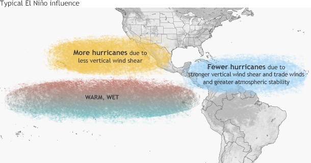
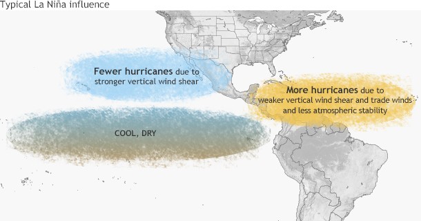
Drag the bar to see the impacts of El Niño and its counterpart La Niña on Hurricane Activity. Read more about it in the blog post by Climate.Gov
Contributed by Chris Landsea (NHC)
The Atlantic hurricane database (or HURDAT) extends back to 1851. However, because tropical storms and hurricanes spend much of their lifetime over the open ocean (some never hitting land) many systems were “missed” during the 19th and early 20th Centuries (Vecchi and Knutson 2008). Starting in 1944, systematic aircraft reconnaissance was commenced for monitoring both tropical cyclones and disturbances that had the potential to develop into tropical storms and hurricanes. This did provide much improved monitoring, but still about half of the Atlantic basin was not covered (Sheets 1990). Beginning in 1966, daily satellite imagery became available at the National Hurricane Center, and thus statistics from this time forward are most complete (McAdie et al. 2009). For hurricanes striking the USA Atlantic and Gulf coasts, one can go back further in time with relatively reliable counts of systems because enough people have lived along coastlines since 1900. Thus, the following records for the entire Atlantic Basin are divided into the pre-Satellite Era (1851-1965) and the Satellite Era (from 1966-present).
| Year | Named Storms | Hurricanes | Major Hurricanes | ACE |
| 1851 | 6 | 3 | 1 | 36 |
| 1852 | 5 | 5 | 1 | 73 |
| 1853 | 8 | 4 | 2 | 76 |
| 1854 | 5 | 3 | 1 | 31 |
| 1855 | 5 | 4 | 1 | 18 |
| 1856 | 6 | 4 | 2 | 49 |
| 1857 | 4 | 3 | 0 | 40 |
| 1858 | 6 | 6 | 0 | 45 |
| 1859 | 8 | 7 | 1 | 56 |
| 1860 | 7 | 6 | 1 | 62 |
| 1861 | 8 | 6 | 0 | 50 |
| 1862 | 6 | 3 | 0 | 46 |
| 1863 | 9 | 5 | 0 | 50 |
| 1864 | 5 | 3 | 0 | 27 |
| 1865 | 7 | 3 | 0 | 49 |
| 1866 | 7 | 6 | 1 | 84 |
| 1867 | 9 | 7 | 1 | 60 |
| 1868 | 4 | 3 | 0 | 35 |
| 1869 | 10 | 7 | 1 | 51 |
| 1870 | 11 | 10 | 2 | 88 |
| 1871 | 8 | 6 | 2 | 88 |
| 1872 | 5 | 4 | 0 | 65 |
| 1873 | 5 | 3 | 2 | 69 |
| 1874 | 7 | 4 | 0 | 47 |
| 1875 | 6 | 5 | 1 | 72 |
| 1876 | 5 | 4 | 2 | 57 |
| 1877 | 8 | 3 | 1 | 73 |
| 1878 | 12 | 10 | 2 | 181 |
| 1879 | 8 | 6 | 2 | 64 |
| 1880 | 11 | 9 | 2 | 131 |
| 1881 | 7 | 4 | 0 | 59 |
| 1882 | 6 | 4 | 2 | 59 |
| 1883 | 4 | 3 | 2 | 67 |
| 1884 | 4 | 4 | 1 | 72 |
| 1885 | 8 | 6 | 0 | 58 |
| 1886 | 12 | 10 | 4 | 166 |
| 1887 | 19 | 11 | 2 | 181 |
| 1888 | 9 | 6 | 2 | 85 |
| 1889 | 9 | 6 | 0 | 104 |
| 1890 | 4 | 2 | 1 | 33 |
| 1891 | 10 | 7 | 1 | 116 |
| 1892 | 9 | 5 | 0 | 116 |
| 1893 | 12 | 10 | 5 | 231 |
| 1894 | 7 | 5 | 4 | 135 |
| 1895 | 6 | 2 | 0 | 69 |
| 1896 | 7 | 6 | 2 | 136 |
| 1897 | 6 | 3 | 0 | 55 |
| 1898 | 11 | 5 | 1 | 113 |
| 1899 | 10 | 5 | 2 | 151 |
| 1900 | 7 | 3 | 2 | 83 |
| 1901 | 13 | 6 | 0 | 99 |
| 1902 | 5 | 3 | 0 | 33 |
| 1903 | 10 | 7 | 1 | 102 |
| 1904 | 6 | 4 | 0 | 30 |
| 1905 | 5 | 1 | 1 | 28 |
| 1906 | 11 | 6 | 3 | 163 |
| 1907 | 5 | 0 | 0 | 13 |
| 1908 | 10 | 6 | 1 | 95 |
| 1909 | 12 | 6 | 4 | 93 |
| 1910 | 5 | 3 | 1 | 64 |
| 1911 | 6 | 3 | 0 | 35 |
| 1912 | 7 | 4 | 1 | 57 |
| 1913 | 6 | 4 | 0 | 36 |
| 1914 | 1 | 0 | 0 | 3 |
| 1915 | 6 | 5 | 3 | 130 |
| 1916 | 15 | 10 | 5 | 144 |
| 1917 | 4 | 2 | 2 | 61 |
| 1918 | 6 | 4 | 1 | 40 |
| 1919 | 5 | 2 | 1 | 55 |
| 1920 | 5 | 4 | 0 | 30 |
| 1921 | 7 | 5 | 2 | 87 |
| 1922 | 5 | 3 | 1 | 55 |
| 1923 | 9 | 4 | 1 | 49 |
| 1924 | 11 | 5 | 2 | 100 |
| 1925 | 4 | 1 | 0 | 7 |
| 1926 | 11 | 8 | 6 | 230 |
| 1927 | 8 | 4 | 1 | 56 |
| 1928 | 6 | 4 | 1 | 83 |
| 1929 | 5 | 3 | 1 | 48 |
| 1930 | 3 | 2 | 2 | 50 |
| 1931 | 13 | 3 | 1 | 48 |
| 1932 | 15 | 6 | 4 | 170 |
| 1933 | 20 | 11 | 6 | 259 |
| 1934 | 13 | 7 | 1 | 48 |
| 1935 | 8 | 5 | 3 | 106 |
| 1936 | 17 | 7 | 1 | 100 |
| 1937 | 11 | 4 | 1 | 66 |
| 1938 | 9 | 4 | 2 | 78 |
| 1939 | 6 | 3 | 1 | 34 |
| 1940 | 9 | 6 | 0 | 68 |
| 1941 | 6 | 4 | 3 | 52 |
| 1942 | 11 | 4 | 1 | 63 |
| 1943 | 10 | 5 | 2 | 94 |
| 1944 | 14 | 8 | 3 | 104 |
| 1945 | 11 | 5 | 2 | 63 |
| 1946 | 6 | 3 | 1 | 22 |
| 1947 | 9 | 5 | 2 | 112 |
| 1948 | 9 | 6 | 4 | 106 |
| 1949 | 13 | 7 | 3 | 98 |
| 1950 | 13 | 11 | 8 | 243 |
| 1951 | 10 | 8 | 5 | 137 |
| 1952 | 7 | 6 | 3 | 87 |
| 1953 | 14 | 6 | 4 | 104 |
| 1954 | 11 | 8 | 2 | 113 |
| 1955 | 12 | 9 | 6 | 199 |
| 1956 | 8 | 4 | 2 | 54 |
| 1957 | 8 | 3 | 2 | 84 |
| 1958 | 10 | 7 | 5 | 121 |
| 1959 | 11 | 7 | 2 | 77 |
| 1960 | 7 | 4 | 2 | 88 |
| 1961 | 11 | 8 | 7 | 205 |
| 1962 | 5 | 3 | 1 | 36 |
| 1963 | 9 | 7 | 2 | 118 |
| 1964 | 12 | 6 | 6 | 170 |
| 1965 | 6 | 4 | 1 | 84 |
| Average 1851-1965 |
8.3 | 5.1 | 1.7 | 83.9 |
Named Storms = Tropical Storms, Hurricanes and Subtropical Storms
Hurricanes = Saffir-Simpson Hurricane Scale 1 to 5
Major Hurricanes = Saffir-Simpson Hurricane Scale 3, 4, or 5
“ACE” = Accumulated Cyclone Energy – An index that combines the numbers of systems, how long they existed and how intense they became. It is calculated by squaring the maximum sustained surface wind in the system every six hours that the cyclone is a Named Storm and summing it up for the season. It is expressed in 104 kt2.
References:
Landsea, C.W., G.A. Vecchi, L. Bengtsson, and T. R. Knutson, 2010: Impact of Duration Thresholds on Atlantic Tropical Cyclone Counts. Journal of Climate, 23(10), 2508-2519.
McAdie, C. J., C. W. Landsea, C. J. Neuman, J. E. David, E. Blake, and G. R. Hamner, 2009: Tropical Cyclones of the North Atlantic Ocean, 1851-2006. Historical Climatology Series 6-2,Prepared by the National Climatic Data Center, Asheville, NC in cooperation with the National Hurricane Center, Miami, FL, 238 pp.
Sheets, R.C., 1990: “The National Hurricane Center – Past, present, and future.”, Wea. Forecasting,5, 185-232.
Vecchi, G.A. and T. R. Knutson, 2008. “On estimates of historical North Atlantic tropical cyclone activity.”, J. Climate, 21, 3580.
Atlantic Basin: Individual years with the numbers in each category
| Year | Named Storms |
Hurricanes | Major Hurricanes |
ACE |
| 1966 | 15 | 7 | 3 | 139 |
| 1967 | 13 | 6 | 1 | 126 |
| 1968 | 9 | 4 | 0 | 47 |
| 1969 | 18 | 12 | 3 | 149 |
| 1970 | 14 | 7 | 2 | 67 |
| 1971 | 13 | 6 | 1 | 97 |
| 1972 | 7 | 3 | 0 | 36 |
| 1973 | 8 | 4 | 1 | 48 |
| 1974 | 11 | 4 | 2 | 68 |
| 1975 | 9 | 6 | 3 | 76 |
| 1976 | 10 | 6 | 2 | 84 |
| 1977 | 6 | 5 | 1 | 25 |
| 1978 | 12 | 5 | 2 | 63 |
| 1979 | 9 | 5 | 2 | 93 |
| 1980 | 11 | 9 | 2 | 149 |
| 1981 | 12 | 7 | 3 | 100 |
| 1982 | 6 | 2 | 1 | 32 |
| 1983 | 4 | 3 | 1 | 17 |
| 1984 | 13 | 5 | 1 | 84 |
| 1985 | 11 | 7 | 3 | 88 |
| 1986 | 6 | 4 | 0 | 36 |
| 1987 | 7 | 3 | 1 | 34 |
| 1988 | 12 | 5 | 3 | 103 |
| 1989 | 11 | 7 | 2 | 135 |
| 1990 | 14 | 8 | 1 | 97 |
| 1991 | 8 | 4 | 2 | 36 |
| 1992 | 7 | 4 | 1 | 76 |
| 1993 | 8 | 4 | 1 | 39 |
| 1994 | 7 | 3 | 0 | 32 |
| 1995 | 19 | 11 | 5 | 228 |
| 1996 | 13 | 9 | 6 | 166 |
| 1997 | 8 | 3 | 1 | 41 |
| 1998 | 14 | 10 | 3 | 182 |
| 1999 | 12 | 8 | 5 | 177 |
| 2000 | 15 | 8 | 3 | 119 |
| 2001 | 15 | 9 | 4 | 110 |
| 2002 | 12 | 4 | 2 | 67 |
| 2003 | 16 | 7 | 3 | 176 |
| 2004 | 15 | 9 | 6 | 227 |
| 2005 | 28 | 15 | 7 | 250 |
| 2006 | 10 | 5 | 2 | 79 |
| 2007 | 15 | 6 | 2 | 74 |
| 2008 | 16 | 8 | 5 | 146 |
| 2009 | 9 | 3 | 2 | 53 |
| 2010 | 19 | 12 | 5 | 165 |
| 2011 | 19 | 7 | 4 | 126 |
| 2012 | 19 | 10 | 2 | 129 |
| 2013 | 14 | 2 | 0 | 36 |
| 2014 | 8 | 6 | 2 | 67 |
| 2015 | 11 | 4 | 2 | 63 |
| 2016 | 15 | 7 | 4 | 141 |
| 2017 | 17 | 10 | 6 | 225 |
| 2018 | 15 | 8 | 2 | 133 |
| 2019 | 18 | 6 | 3 | 132 |
| 2020 | 30 | 14 | 6 | 184 |
| 2021 | 21 | 7 | 4 | 146 |
| 2022 | 14 | 8 | 2 | 95 |
| 2023 | 20 | 7 | 3 | 148 |
| 2024 | 18 | 11 | 5 | 161 |
| Average 1966-2024 |
13.0 | 6.6 | 2.6 | 105.4 |
Named Storms = Tropical Storms, Hurricanes and Subtropical Storms
Hurricanes = Saffir-Simpson Hurricane Scale 1 to 5
Major Hurricanes = Saffir-Simpson Hurricane Scale 3, 4, or 5
“ACE” = Accumulated Cyclone Energy – An index that combines the numbers of systems, how long they existed and how intense they became. It is calculated by squaring the maximum sustained surface wind in the system every six hours that the cyclone is a Named Storm and summing it up for the season. It is expressed in 104 kt2.
References:
Landsea, C.W., G.A. Vecchi, L. Bengtsson, and T. R. Knutson, 2010: Impact of Duration Thresholds on Atlantic Tropical Cyclone Counts. Journal of Climate, 23(10), 2508-2519.
McAdie, C. J., C. W. Landsea, C. J. Neuman, J. E. David, E. Blake, and G. R. Hamner, 2009: Tropical Cyclones of the North Atlantic Ocean, 1851-2006. Historical Climatology Series 6-2,Prepared by the National Climatic Data Center, Asheville, NC in cooperation with the National Hurricane Center, Miami, FL, 238 pp.
Sheets, R.C., 1990: “The National Hurricane Center – Past, present, and future.”, Wea. Forecasting,5, 185-232.
Vecchi, G.A. and T. R. Knutson, 2008. “On estimates of historical North Atlantic tropical cyclone activity.”, J. Climate, 21, 3580.
Click here for a complete list of hurricane landfalls in the continental United States.
The primary time of year for getting tropical cyclones is during the summer and autumn: July-October for the Northern Hemisphere and December-March for the Southern Hemisphere (though there are differences from basin to basin). The peak in summer/autumn is due to having all of the necessary ingredients become most favorable during this time of year: warm ocean waters (at least 26°C or 80°F), a tropical atmosphere that can quite easily kick off convection (i.e. thunderstorms), low vertical shear in the troposphere, and a substantial amount of large-scale spin available (either through the monsoon trough or easterly waves).
While one would intuitively expect tropical cyclones to peak right at the time of maximum solar radiation (late June for the tropical Northern Hemisphere and late December for the tropical Southern Hemisphere), it takes several more weeks for the oceans to reach their warmest temperatures. The atmospheric circulation in the tropics also reaches its most pronounced (and favorable for tropical cyclones) at the same time. This time lag of the tropical ocean and atmospheric circulation is analogous to the daily cycle of surface air temperatures – they are warmest in mid-afternoon, yet the sun’s incident radiation peaks at noon.
What never? Well, hardly ever.
In March, 2004 a hurricane DID form in the South Atlantic Ocean and made landfall in Brazil. But this still leaves the question of why hurricanes are so rare in the South Atlantic. Though many people might speculate that the sea surface temperatures are too cold, the primary reasons that the South Atlantic Ocean gets few tropical cyclones are that the tropospheric (near surface to 200mb) vertical wind shear is much too strong and there is typically no inter-tropical convergence zone (ITCZ) over the ocean (Gray 1968). Without an ITCZ to provide synoptic vorticity and convergence (i.e. large scale spin and thunderstorm activity) as well as having strong wind shear, it becomes very difficult to nearly impossible to have genesis of tropical cyclones.
In addition, McAdie and Rappaport (1991) documented the occurrence of a strong tropical depression/weak tropical storm that formed off the coast of Congo in mid-April of 1991. This storm lasted about five days and drifted toward the west-southwest into the central South Atlantic. So far, there has not been a systematic study as to the conditions that accompanied this rare event.
Hurricanes form both in the Atlantic basin (i.e. the Atlantic Ocean, Gulf of America and Caribbean Sea) to the east of the continental U.S. and in the Northeast Pacific basin to the west of the U.S. However, the ones in the Northeast Pacific almost never hit the continental U.S., while the ones in the Atlantic basin strike the U.S. mainland just less than twice a year on average. There are two main reasons. The first is that hurricanes tend to move toward the west-northwest after they form in the tropical and subtropical latitudes. In the Atlantic, such a motion often brings the hurricane into the vicinity of the U.S. east coast. In the Northeast Pacific, a west-northwest track takes those hurricanes farther off-shore, well away from the U.S. west coast.
In addition to the general track, a second factor is the difference in water temperatures along the U.S. east and west coasts. Along the U.S. east coast, the Gulf Stream provides a source of warm (> 80°F or 26.5°C) waters to help maintain the hurricane. However, along the U.S. west coast, the ocean temperatures rarely get above the lower 70s, even in the midst of summer. Such relatively cool temperatures are not energetic enough to sustain a hurricane’s strength. So for the occasional Northeast Pacific hurricane that does track back toward the U.S. west coast, the cooler waters can quickly reduce the strength of the storm. You may have remnants of such storms move over the Southwestern United States bringing heavy rainfall.
Recently Chenoweth and Landsea (2004), re-discovered that a hurricane struck San Diego, California on October 2, 1858. Unprecedented damage was done in the city and was described as the severest gale ever felt to that date nor has it been matched or exceeded in severity since. The hurricane force winds at San Diego are the first and only documented instance of winds of this strength from a tropical cyclone in the recorded history of the state. While climate records are incomplete, 1858 may have been an El Niño year, which would have allowed the hurricane to maintain intensity as it moved north along warmer than usual waters. Today if a Category 1 hurricane made a direct landfall in either San Diego or Los Angeles, damage from such a storm would likely be few to several hundred million dollars. The re-discovery of this storm is relevant to climate change issues and the insurance/emergency management communities risk assessment of rare and extreme events in the region.
Reference: Chenoweth, M., and C.W. Lansea (2004): “The San Diego hurricane of October 2, 1858” Bull. Amer. Meteor. Soc., 85, pp.1689-1697
The vast majority of Atlantic activity takes place during August-September-October, the climatological peak months of the hurricane season. The overall number of named storms (hurricanes) occurring in June and July (JJ) correlates at an insignificant r = +0.13 (+0.02) versus the whole season activity. In fact, there is a slight negative relationship between early season storms (hurricanes) versus late season – August through November – r = -0.28 (-0.35). Thus, the overall early season activity, be it very active or quite calm, has little bearing on the season as a whole. These correlations are based on the years 1944-1994.
A significant number of pre-season (April-May) and early season (JJ) storms are hybrid systems (neither fully tropical nor midlatitude lows). So their formation mechanisms are very different from fully tropical systems that form in the Main Development Region (MDR). So conditions favoring hybrid storm formation can be very different from those favoring tropical cyclone formation.
As shown in (Goldenberg 2000), if one looks only at the June-July Atlantic tropical storms and hurricanes occurring south of 22°N and east of 77°W (the eastern portion of the MDR for Atlantic hurricanes), there is a strong association with activity for the remainder of the year. According to the data from 1944-1999, total overall Atlantic activity for years that had a tropical storm or hurricane form in this region during JJ have been at least average and often above average. So it could be said that a JJ storm in this region is pretty much a “sufficient” (though not “necessary”) condition for a year to produce at least average activity. (I.e., Not all years with average to above-average total overall activity have had a JJ storm in that region, but almost all years with that type of JJ storm produce average to above-average activity.) The formation of a storm in this region during June-July is taken into account when the August updates for the Bill Gray and NOAA seasonal forecasts are issued.
The El Niño/Southern Oscillation (ENSO) resolves into a warm phase (El Niño), a cold phase (La Niña), and a neutral phase. During El Niño events (ENSO warm phase), tropospheric vertical shear is increased inhibiting tropical cyclone genesis and intensification, primarily by causing the 200 mb (12 km or 8 mi) westerly winds to be stronger (Gray 1984). La Niña events (ENSO cold phase) enhances activity. Recently, Tang and Neelin (2004) also identified that changes to the moist static stability can also contribute toward hurricane changes due to ENSO, with a drier, more stable environment present during El Niño events.
The Australian/Southwest Pacific shows a pronounced shift back and forth of tropical cyclone activity with fewer tropical cyclones between 145° and 165°E and more from 165°E eastward across the South Pacific during El Niño (warm ENSO) events. There is also a smaller tendency to have the tropical cyclones originate a bit closer to the equator. The opposite would be true in La Niña (cold ENSO) events. See papers by Nicholls (1979), Revell and Goulter (1986), Dong (1988), and Nicholls (1992). The western portion of the Northeast Pacific basin (140°W to the dateline) has been suggested to experience more tropical cyclone genesis during the El Niño year and more tropical cyclones tracking into the sub-region in the year following an El Niño (Schroeder and Yu 1995), but this has not been completely documented yet.
The Northwest Pacific basin, similar to the Australian/Southwest Pacific basin, experiences a change in location of tropical cyclones without a total change in frequency. Pan (1981), Chan (1985), and Lander (1994) detailed that west of 160°E there were reduced numbers of tropical cyclone genesis with increased formations from 160E to the dateline during El Niño events. The opposite occurred during La Niña events. Again there is also the tendency for the tropical cyclones to also form closer to the equator during El Niño events than average.
The eastern portion of the Northeast Pacific, the Southwest Indian, the Southeast Indian/Australian, and the North Indian basins have either shown little or a conflicting ENSO relationship and/or have not been looked at yet in sufficient detail.
Reference: Tang, B. H., and J. D. Neelin, 2004: “ENSO Influence on Atlantic hurricanes via tropospheric warming.” Geophys. Res. Lett.: Vol 31, L24204.
There is no debate that hurricane activity is strongly linked to short-term climate swings that last for approximately a year (ENSO) and for tens of years (known as “multi-decadal variability”), but there is an ongoing scientific debate about longer-term (30+ years) climate trends: how much is due to natural phenomena, how much is due to human activities, and how they affect tropical cyclone activity.
Atlantic hurricanes respond to the environment that they travel through. For example, when the tropical North Atlantic Ocean is warmer than usual, hurricanes tend to form more often and become stronger. However, when vertical wind shear is higher than normal over the basin, fewer storms form and are weaker.
Over the past 100 years and longer, the Atlantic hurricane environment has displayed climate swings known as “multi-decadal variability”, and hurricane activity has followed these swings. For example, in the 1940s through 1960s, ocean temperatures were warmer and hurricane seasons were more active than usual. This situation reversed during the 1970s and 1980s, which was a period of cooler ocean temperature and quieter than usual hurricane seasons. Since around the mid-1990s, we’ve been in another period of warmer than usual ocean temperatures and heightened hurricane activity.
Ocean temperatures in the region where most Atlantic hurricanes form and develop have been trending upwards as the Earth has gradually warmed since the mid-19th Century (top panel, Fig. 1). In addition to trending upwards, ocean temperatures show large multi-decadal climate swings from cooler to warmer than average. This becomes clearer when the warming trend is removed (middle panel). Atlantic hurricane activity has responded to these swings in a variety of ways. For example, the number of Atlantic major hurricanes (Saffir-Simpson categories 3–5) is greater during periods of warmer than usual temperatures (bottom panel).
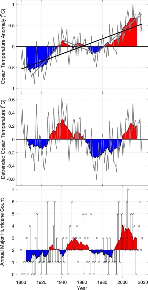
Recent research describes two distinct types of Atlantic climate drivers: 1) Internal variability is caused by natural processes within the atmosphere and ocean climate system. 2) External variability is caused by forces outside of the atmosphere/ocean climate system.
Examples of natural internal forces are oceanic oscillations such as ENSO, meridional overturning circulation, and Saharan dust storms that blow mineral dust over the tropical Atlantic. The effects of the El Nino/Southern Oscillation are discussed in another section in detail.
Examples of external climate forcing agents are solar variability, cosmic radiation changes, and air pollution such as industrial particulate and sulfur emissions.
The Atlantic meridional overturning circulation, which transports ocean heat from the tropics to higher latitudes and can cause substantial climate swings in the Atlantic region and beyond as this circulation increases or decreases.
Saharan dust storms have a similar effect on the Atlantic climate as the dust blows westward in the trade-winds off the African continent and blocks sunlight from reaching the ocean surface. Saharan dust storms are strongly seasonal, but can also exhibit multi-decadal swings that can cause similar swings in Atlantic ocean temperatures.
Our sun has 11-year and 22-year cycles in sunspot and magnetic activity, which affects the solar wind and Earth’s magnetic field. It may also exhibit longer scale variability in its output. Along with changes in comic ray activity, this may alter Earth’s cloud cover in subtle ways and drive changes in ocean heat content.
Volcanic eruptions cause a transient cooling of ocean temperatures as they tend to block some of the incoming sunlight from reaching the surface. These natural eruptions tend to occur randomly and don’t exhibit any clear multi-decadal swings.
Finally, there is human-caused particulate and sulfate air pollution, which tends to block incoming sunlight similarly to volcanic eruptions and mineral dust. Human-caused sulfate pollution over the Atlantic exhibits a pronounced variability over time. Prior to the various Clean Air Acts and Amendments instituted by the United States and European countries in the 1970s, industrial sulfate emissions were much less regulated and air quality had become progressively worse. As the concentration of sulfate pollution over the Atlantic Ocean increased from the 1940s through 1970s, a cooling effect was noted as the pollution blocked incoming sunlight. According to some studies, as sulfate pollution concentrations decreased during and after the 1970s, the offsetting cooling effect is believed to have been reduced.
In November 2006 the global community of tropical cyclone researchers and forecasters as met at the 6th International Workshop on Tropical Cyclones of the World Meteorological Organization in San Jose, Costa Rica. They released a statement on the links between anthropogenic (human-induced) climate change and tropical cyclones, including hurricanes and typhoons. The following is a summary of their report.
- There have been a number of recent high-impact tropical cyclone events around the globe. These include 10 landfalling tropical cyclones in Japan in 2004, five tropical cyclones affecting the Cook Islands in a five-week period in 2005, Cyclone Gafilo in Madagascar in 2004, Cyclone Larry in Australia in 2006, Typhoon Saomai in China in 2006, and the extremely active 2004 and 2005 Atlantic tropical cyclone seasons – including the catastrophic socio-economic impact of Hurricane Katrina.
- Some recent scientific articles have reported a large increase in tropical cyclone energy, numbers, and wind-speeds in some regions during the last few decades in association with warmer sea surface temperatures. Other studies report that changes in observational techniques and instrumentation are responsible for these increases.
Consensus Statements by International Workshop on Tropical Cyclones-VI (IWTC-VI) Participants :
- Though there is evidence both for and against the existence of a detectable anthropogenic signal in the tropical cyclone climate record to date, no firm conclusion can be made on this point.
- No individual tropical cyclone can be directly attributed to climate change.
- The recent increase in societal impact from tropical cyclones has largely been caused by rising concentrations of population and infrastructure in coastal regions.
- Tropical cyclone wind-speed monitoring has changed dramatically over the last few decades, leading to difficulties in determining accurate trends.
- There is an observed multi-decadal variability of tropical cyclones in some regions whose causes, whether natural, anthropogenic or a combination, are currently being debated. This variability makes detecting any long-term trends in tropical cyclone activity difficult.
- It is likely that some increase in tropical cyclone peak wind-speed and rainfall will occur if the climate continues to warm. Model studies and theory project a 3-5% increase in wind-speed per degree Celsius increase of tropical sea surface temperatures.
- There is an inconsistency between the small changes in wind-speed projected by theory and modeling versus large changes reported by some observational studies.
- Although recent climate model simulations project a decrease or no change in global tropical cyclone numbers in a warmer climate, there is low confidence in this projection. In addition, it is unknown how tropical cyclone tracks or areas of impact will change in the future.
- Large regional variations exist in methods used to monitor tropical cyclones. Also, most regions have no measurements by instrumented aircraft. These significant limitations will continue to make detection of trends difficult.
- If the projected rise in sea level due to global warming occurs, then the vulnerability to tropical cyclone storm surge flooding would increase.
A PDF version of the official report is available here.
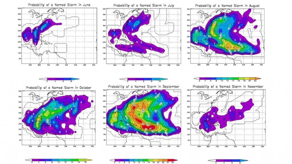
This figure shows, at any particular location, what the chance is that a tropical storm or hurricane will affect an area during an individual month. We utilized the years 1944 to 1999 in the analysis and counted hits when a storm or hurricane was within about 100 miles (165 km).
Typically, for someone visiting the tropics during June through November, the chance to experience (or even be threatened by) a hurricane is very small.
 As an example, this figure shows the chances to have a direct hit by a hurricane during the month of September, which is usually the busiest month. If we look at Puerto Rico, the chance is 8% of experiencing a hurricane, if you are there for the WHOLE month. If you are there for, say, only a week, then the chance would be one fourth of that – or only about 2% chance.
To put this into perspective, if you made 50 one week trips to Puerto Rico in September, you would only experience a direct hit in ONE of those 50 visits. So the chances to get impacted by a hurricane are quite small for relatively short trips. And the case chosen here is the WORST possible, as all other locations in all other months have smaller chances of being hit by a hurricane.
Despite the chance being small, one should know in advance what your hotel’s, cruise company’s, etc. policy is for guests when a hurricane is coming, what actions they plan and what refund policies they have (if any). As is described above, a direct hit by a hurricane is a very rare event for a short visit and if I had a chance – for example – to go on a cruise in the Caribbean Sea during hurricane season, I would go without hesitation.
The forward speed of hurricanes is very latitude dependent. Typically, Atlantic hurricanes track along the western side of the subtropical ridge in the western Atlantic. As they recurve (turn more northerly) from their westward track they usually slow down. If they reach the midlatitudes, they can interact with upper-level troughs and pick up speed.
In the table below, the forward speed of hurricanes in the HURDAT database have been averaged in 5 degree latitude bins :
| Latitude bin |
Speed | No. Cases |
||
| km/hr | knt | mph | ||
| 0°- 5°N | 25.9 | 14.0 | 16.1 | 186 |
| 5°-10°N | 22.0 | 11.9 | 13.7 | 4678 |
| 10°-15°N | 19.2 | 10.4 | 11.9 | 7620 |
| 15°-20°N | 17.4 | 9.4 | 10.8 | 7501 |
| 20°-25°N | 17.5 | 9.4 | 10.8 | 8602 |
| 25°-30°N | 20.1 | 10.8 | 12.5 | 6469 |
| 30°-35°N | 27.1 | 14.6 | 16.9 | 3397 |
| 35°-40°N | 39.0 | 21.0 | 24.2 | 1120 |
| 40°-45°N | 49.3 | 26.6 | 30.6 | 264 |
| 45°-50°N | 51.5 | 27.8 | 32.0 | 34 |
| 50°-55°N | 51.4 | 27.8 | 32.0 | 15 |
| 55°-60°N | 55.8 | 30.1 | 34.7 | 1 |
While there are many cases where the forward speed over the 6 hour interval in the hurricane database is zero, such as Mitch in 1998, the highest speed in the database is for unnamed Tropical Storm #6 in 1961. As it got caught up by a midlatitude trough over the mid Atlantic states, it went speeding off northeastward over Maine and New Brunswick at a maximum speed of 112.25 km/hr (60.57 kt or 69.75 mph). The fastest hurricane in the record was Emily in 1987, whose maximum speed reached 110.48 km/hr (59.61 kt or 68.65 mph) as it raced over the North Atlantic, before it turned extratropical.
Historical Hurricane Tracks at NOAA's Ocean Service
For an interactive historical hurricane track map, visit the NOAA Historical Hurricane Tracks tool by NOAA’s Ocean Service.
Hurricane Timeline 1494-1800
1494- 1800
- 1494 During his second voyage, Christopher Columbus shelters his fleet from a tropical cyclone. This is the first written European account of a hurricane.
- 1502 During his fourth voyage Columbus warns the governor of Santo Domingo of an approaching hurricane, but is ignored. A Spanish treasure fleet sets sail and loses 20 ships with 500 men.
- 1565 A French fleet sent to support Ft. Caroline is devastated by a hurricane. The Spaniards at St. Augustine massacre the colonists at Ft. Caroline ensuring Spanish control of East Florida.
- 1609 The British ship Sea Venture is damaged by a hurricane but manages to find refuge on uninhabited Bermuda archipelago. The islands become a British colony.
- 1635 The Great Colonial Hurricane strikes the young Massachusetts Bay and Plymouth colonies.
- 1667 The Dreadful Hurricane strikes the Virginia colonies.
- 1703 A severe storm (possibly a hurricane) strikes England. Daniel Defoe gathers eyewitness accounts and publishes them in “The Storm.”
- 1743 A hurricane prevents Ben Franklin from observing a lunar eclipse in Philadelphia. When he later learns his brother in Boston experienced the storm much later, he surmises that hurricanes don’t move in the direction that the winds are blowing. Also, Professor Winthrop of Harvard makes first pressure and tide observations during this hurricane.
- 1780 The Great Hurricane leaves over 22,000 dead across the Antilles.
References:
Fitzpatrick, Patrick “Natural Disasters : Hurricanes” 1999 ABC-CLIO Publishers, Santa Barbara, CA
Ludlum, David “Early American Hurricanes 1492-1870” 1963 Lancaster Press, Lancaster, PA
Simpson, Robert ed. “Hurricane! Coping with Disaster” 2003 American Geophysical Union, Washington, DC
Hurricane Timeline 1801-1900
1801- 1900
- 1815 Professor Farrar of Harvard observes winds as a hurricane, known as the ‘Great September Gale’, passes Boston and concludes that the storm is a large, moving vortex.
- 1821 William Redfield observes counter-clockwise pattern to damage across Connecticut following a hurricane.
- 1831 Redfield publishes his observation of 1821 hurricane damage and theorizes storms are large, moving vortices. He begins compiling hurricane tracks.
- A major hurricane strikes Barbados. Lt. Col William Reid of the Royal Engineers is sent to survey the damage.
- 1837 Racer’s Hurricane devastates much of the Gulf coast.
- 1838 Reid publishes his “Law of Storms” which advises mariners on how to avoid a hurricane at sea.
- 1847 Reid establishes a hurricane warning network in Barbados.
- 1848 The Smithsonian Museum organizes a network of weather observers across the United States and its territories.
- 1855 Andres Poey publishes a chronology of over 400 hurricanes since the time of Columbus.
- 1856 A hurricane wipes out the resort on Last Island, Louisiana.
- 1865 Manila Observatory is founded in the Philippines with Fr. Faura as its first director. Begins study of typhoons and creates an observing network.
- 1870 Fr. Benito Viñes becomes head of Meteorological Observatory at Belen College in Havana, and begins research on hurricanes. He establishes an observing network across Cuba.
- The United States Government forms its National Weather Service under Army’s Signal Service.
- 1873 The National Weather Service issues its first hurricane warning.
- 1875 Viñes issues his first hurricane warning.
- 1877 Viñes publishes “Relative Points of the Hurricanes of the Antilles in September and October of 1875 and 1876”, in which he details using waves and cloud motions to forecast hurricanes.
- 1879 Faura makes first typhoon forecast.
- 1890 U.S. Weather Bureau established from Army’s National Weather Service. Made a civilian agency under the Department of Agriculture.
- 1893 The deadliest hurricane year in U.S. history, as the “Sea Islands” hurricane kills 1000 to 2000 people, the “Chenier Caminada” hurricane causes about 2000 deaths, and another major hurricane strikes the Carolinas in mid-October.
- 1897 Fr. Algue’ publishes book cataloging and categorizing typhoon tracks.
- 1898 The U.S. Weather Bureau establishes a hurricane warning center at Kingston, Jamaica. After the Spanish-American War it’s moved to Havana.
- Viñes’ “Investigations Relating to the Circulation and Cyclonic Translation of Hurricanes of the Antilles” published by U.S. Weather Bureau.
- 1900 A devastating hurricane strikes Galveston resulting in over 8000 deaths (or perhaps as many as 12,000).
- Edward Garriott writes USWB Bulletin H “West Indian Hurricanes” based mostly on Viñes’ work.
References:
Fitzpatrick, Patrick “Natural Disasters : Hurricanes” 1999 ABC-CLIO Publishers, Santa Barbara, CA
Ludlum, David “Early American Hurricanes 1492-1870” 1963 Lancaster Press, Lancaster, PA
Simpson, Robert ed. “Hurricane! Coping with Disaster” 2003 American Geophysical Union, Washington, DC
Hurricane Timeline 1901-1950
1901- 1950
- 1902 Weather Bureau moves its hurricane forecast center from Havana to Washington, DC.
- 1906 Cuba establishes its National Observatory under its Navy. Assumes hurricane warning duties from Belen Observatory.
- 1909 Grand Isle, LA is struck by a major hurricane, killing 350 people.
- 1910 Cyclone of the Five Days ravages western Cuba twice. At first Belen scientists believe it to be two seperate hurricanes, but Jose Carlos Millas theorizes it was the same storm looping in the Yucatan Channel.
- 1913 Oliver Fassig publishes “Hurricanes of the West Indies”.
- 1919 Sakuhei Fujiwara notes that hurricanes move with the larger scale synoptic flow.
- Over 600 deaths are caused by a hurricane striking the Florida Keys and then Corpus Christi, Texas. Storm surge leaves lasting impression on young Robert Simpson.
- 1921 Fujiwara publishes paper on the interaction of two tropical cyclones noting what becomes known as the “Fujiwhara Effect”.
- 1922 Edward Bowie observes that most hurricanes move anti-cyclonically around the subtropical ridge.
- 1924 Charles Mitchell publishes “West Indies Hurricanes and other Tropical Cyclones” in Monthly Weather Review. Traces many hurricanes to disturbances near Cape Verde Islands.
- 1926 Issac Cline publishes his major book “Tropical Cyclones.”
- The Great Miami hurricane crashes into Florida causing tremendous damage and a month later another hurricane strikes Havana causing over 600 casualties.
- 1928 The Lake Okeechobee hurricane kills nearly 2500 people. Also known as the ‘San Felipe’ hurricane in Puerto Rico where it killed over 300 people.
- 1935 The Weather Bureau revamps its hurricane warning service, and divides responsibilities between New Orleans, Jacksonville, San Juan, and Washington, DC. Boston is added later.
- The Labor Day hurricane hits the Florida Keys with over 400 killed. This is the most intense hurricane to have been recorded in the U.S..
- 1938 The New England hurricane strikes Long Island and Rhode Island causing over 600 deaths.
- Ivan Tannehill publishes “Hurricanes, Their Nature and History”.
- 1939 Fr. Deppermann publishes “Some Characteristics of Philippine Typhoons” in which he presents a theoretical model of tropical cyclones.
- 1940 Gordon Dunn demonstrates that most Atlantic hurricanes form from tropical easterly waves rather than baroclinic zones.
- 1943 The Weather Bureau’s Jacksonville hurricane warning center is moved to Miami where a joint center with the Navy and Air Corps is established.
- Major Joseph Duckworth flies his AT-6 trainer airplane into a hurricane over Texas proving the utility of this method of reconnaissance.
- 1944 The Great Atlantic hurricane sweeps up the eastern seaboard and causes 390 casualties, mostly at sea. This is the first hurricane with scheduled aircraft reconnaissance and the first radar depiction of a hurricane eye and spiral rainbands.
- Major Harry Wexler and Lloyd Woods fly into Great Atlantic hurricane and find that updrafts are confined to a small area near the eye.
- Herbert Riehl and Major Robert Shafer find that large vertical wind shear is inimical to tropical cyclone formation and development.
- Halsey’s Third Fleet runs into Typhoon Cobra in the Pacific with the loss of 3 destroyers and 790 men.
- 1945 The Navy and Air Force begin identifying typhoons by women’s names.
- Pacific fleet has another disastrous run in this time with Typhoon Viper.
- Major hurricane strikes Miami and travels up Florida peninsula. Lt. Robert Atlas makes time lapse movie of Army radar scope as storm approaches Orlando.
- 1946 The Navy and Air Force organize Hurricane Hunter squadrons in the Atlantic and Typhoon Trackers and Typhoon Chasers in the Pacific.
- 1947 Navy planes seed an Atlantic hurricane as part of Project Cirrus.
- Bob Simpson ‘piggybacks’ a research mission onto an Air Force reconnaissance flight into a hurricane. This is the first detailed examination of the upper level circulation of the hurricane core.
- 1947-1948 Four hurricanes over two years strike South Florida causing persistent flooding. This leads to the formation of the South Florida Water Management District.
- 1948 Eric Palmen publishes a study showing that hurricanes require at least 80 F (26 C) water in order to form. Same study attempts to map out vertical structure of a hurricane from balloon soundings.
- 1950 The Weather Bureau officially begins naming Atlantic hurricanes.
- Hurricane King strikes Miami and affects much of Florida.
- Hurricane Easy loops over Cedar Key, FL and keeps that island under hurricane force winds for 18 continuous hours.
References:
Fitzpatrick, Patrick “Natural Disasters : Hurricanes” 1999 ABC-CLIO Publishers, Santa Barbara, CA
Ludlum, David “Early American Hurricanes 1492-1870” 1963 Lancaster Press, Lancaster, PA
Simpson, Robert ed. “Hurricane! Coping with Disaster” 2003 American Geophysical Union, Washington, DC
Hurricane Timeline 1951-2000
1951-2000
- 1951 Simpson flies ‘piggyback’ research mission into Typhoon Marge, measuring its warm core and record low pressure eye.
- 1954 Tropical depression detected by camera on a Navy rocket. This demonstrates the utility of weather observations from space.
- Hurricanes Carol and Edna strike New England in succession.
- Simpson schedules last of the ‘piggyback’ research missions on an Air Force reconnaissance flight into Hurricane Edna, but is preempted by Edward R. Murrow and his CBS “See It Now’ crew.
- Hurricane Hazel slams into the Carolinas and causes destruction all the way to Toronto. Grady Norton dies during the ongoing effort to forecast this storm.
- 1955 Miami office of the US Weather Bureau is designated the primary hurricane center responsible for forecasting and issuing warnings for hurricanes in the Atlantic.
- The US Weather Bureau founds the National Hurricane Research Project which begins research flights into hurricanes the next year.
- Three hurricanes make landfall in North Carolina this year including Hurricane Diane, the “Billion Dollar Hurricane”.
- Joint Numerical Weather Prediction unit formed by US Weather Bureau, Navy, and Air Force to use computers to forecast the weather.
- Tannehill publishes “The Hurricane Hunters” about aircraft reconnaissance.
- 1956 Riehl and William Haggard develop the first statistical hurricane track forecast techniques.
- Julian Adem describes the “beta effect” on the motion of hurricanes.
- 1957 Hurricane Audrey causes over 500 deaths in Louisiana and Texas.
- 1958 Marjory Stoneman Douglas publishes “Hurricane”, a popular history about Atlantic hurricanes.
- Navy launches a radar-tracked ‘Brango Ball’ into eye of Hurricane Helene. Later, the NHRP and the Air Force release a balloon beacon into Helene’s eye and successfully tracks it remotely.
- First real-time hurricane track forecast made by computer.
- 1959 The Joint Typhoon Warning Center is formed in Guam, combining the Navy and Air Force Pacific forecasting efforts.
- Dunn and researchers begin a five year program to study hurricane track forecasts and evaluated various objective techniques.
- 1960 TIROS I, the first experimental weather satellite, is launched and promptly discovers an undetected tropical cyclone near New Zealand.
- Hurricane Donna roars through the Florida Keys and then up to North Carolina and Connecticut causing 50 deaths.
- Dunn and Banner Miller publish “Atlantic Hurricanes”, the most up-to-date summary of hurricane science at the time.
- 1961 The Research Flight Facility (RFF) is formed to manage and operate the Dept. of Commerce’s hurricane research aircraft.
- RFF aircraft monitor Hurricane Carla from tropical depression stage all the way until its landfall in Texas.
- Dan Rather makes his mark covering the landfall of Hurricane Carla sometimes from the seawall at Galveston. CBS network executives take note.
- Navy and RFF planes seed Hurricane Esther.
- 1962 Project STORMFURY is begun, a joint effort of the Weather Bureau, Navy, and National Science Foundation to test if seeding hurricanes can reduce their winds,
- 1963 STORMFURY planes seed Hurricane Beulah with encouraging results.
- Victor Ooyama formulates his theory of tropical cyclone formation.
- Jule Charney and Arnt Eliasson formulate their CISK theory of tropical cyclone formation.
- 1964 Miller and Peter Chase create NHC-64, the first in a long line of statistical-dynamical track forecast programs. It is first used operationally during 1964 hurricane season.
- 1965 Hurricane Betsy crashes through the Bahamas, Florida Keys, and Louisiana killing 75 people.
- Department of Commerce combines US Weather Bureau and US Coast and Geodetic Survey to form Environmental Science Services Administration (ESSA).
- 1967 Air Force joins Project STORMFURY.
- US Weather Bureau’s Miami hurricane forecast office separated from regular weather forecast office and designated National Hurricane Center (NHC).
- 1968 Charlie Neumann and John Hope create a hurricane database of Atlantic hurricanes later known as HURDAT.
- Harry Hawkins and Daryl Rubsam publish influential papers on the structure and energy budget of Hurricane Hilda.
- 1969 Ooyama creates 2D hurricane computer simulation.
- Project BOMEX attempts to define the air-sea fluxes in the tropical Atlantic.
- Project STORMFURY seeds Hurricane Debbie on two days. It is the most successful implementation of the experiment to date.
- Hurricane Camille strikes Mississippi coast as only the second Category Five hurricane recorded in US history. She leaves 260 dead in her wake.
- NHC director Simpson works with engineer Herb Saffir to modify the latter’s hurricane damage scale to include wind speed regimes, creating the Saffir-Simpson scale.
- 1970 National Oceanic and Atmospheric Administration (NOAA) is formed, unifying many government oceanographic facilities and ESSA, including US Weather Bureau, which is renamed National Weather Service.
- Fred Sanders’ SANBAR, the first barotropic hurricane track computer forecast model, is put into operation.
- A tropical cyclone rushing up the Bay of Bengal causes over half of a million deaths in Bangladesh and India.
- 1971 Richard Anthes creates the first 3D hurricane simulation.
- Navy Typhoon Trackers (VW-1) disestablished.
- Project STORMFURY seeds Hurricane Ginger. This is the last field experiment carried out by the Project.
- 1972 Neumann develops CLIPER, a statistical hurricane track forecast scheme, used as a benchmark for other model’s forecast skill scores.
- Roland Madden and Paul Julian describe a global scale pressure wave which seems to enhance tropical convection known as the Madden-Julian Oscillation (MJO).
- Hurricane Agnes floods areas along the eastern seaboard causing over 120 deaths.
- Bob Burpee publishes a paper explaining the origin and structure of African easterly waves.
- 1974 The Navy disbands its Hurricane Hunter squadrons.
- The GATE experiment in the east Atlantic measures tropical waves as they come off the African coast.
- Cyclone Tracy devastates Darwin, Australia.
- 1975 Vern Dvorak proposes a scheme to estimate tropical cyclone strength from satellite pictures.
- 1977 A tropical cyclone in India kills over 10,000.
- 1979 Neumann and Brian Jarvinen develop SHIFOR, a statistical scheme to forecast hurricane intensity, used as a benchmark for intensity forecast skill scores.
- The First Global GARP Experiment attempts to delineate a world-wide profile of the the Earth atmosphere during two intense observation periods in the winter and summer.
- Hurricane David chews a path of destruction through eastern Caribbean islands and the Bahamas before brushing up U.S. East Coast.
- Hurricane Frederic intensifies over the Gulf of America before impacting the U.S. Gulf coast.
- 1980 Hurricane Allen roars through the Caribbean and Gulf of America as a Category Five hurricane.
- 1982 The first Synoptic Flow experiment is flown around Hurricane Debby to help define the large scale atmospheric winds that steer the storm using dropsondes.
- Anthes publishes “Tropical Cyclones, Their Evolution, Structure, and Effects”.
- Hugh Willoughby, Jean Clos, and Mohamed Shoreibah publish a paper on hurricane eyewall cycles.
- 1983 Project STORMFURY is officially ended.
- Hurricane Alicia forms from an old frontal boundary in the Gulf of America and hits Galveston and Houston.
- 1984 William Gray and his Colorado State team issue the first hurricane seasonal forecast.
- 1985 Willoughby, Bob Black, Stan Rosenthal, and Dave Jorgensen write an assessment of Project STORMFURY which documents several flaws in the assumptions in planning the experiments that call the results into question.
- Hurricane Gloria roars up the eastern seaboard threatening New York City, but eventually makes landfall on Long Island.
- 1987 The Air Force disbands its Pacific Typhoon Chasers squadrons.
- 1988 Hurricane Gilbert has the lowest central pressure to date (888 mb) ever estimated for an Atlantic hurricane just before striking the Yucatan peninsula.
- 1989 Hurricane Hugo makes a direct hit on Charleston, SC and causes over 20 casualties.
- BAM, the Beta and Advection Model, and VICBAR, a nested barotropic hurricane track forecast model become operational.
- 1990 Mark DeMaria and John Kaplan create SHIPS a statistical hurricane intensity forecast scheme.
- Roger Pielke Sr. publishes “The Hurricane”.
- TCM-90 Experiment attempts to define factors contributing to typhoon motion such as synoptic winds and the beta effect.
- 1991 TEXMex is an MIT/NOAA joint project carried out in the eastern Pacific to examine the genesis of tropical cyclones.
- The Air Force transfers its Hurricane Hunters to the Air Force Reserves.
- 1992 Hurricane Andrew levels parts of south Florida and causes over $26 billion in damages there, in the Bahamas, and Louisiana.
- NCEP’s Aviation model becomes operational.
- Super Typhoon Omar hits Guam causing $457 million in damage.
- TCM-92 Experiment combines satellite and aircraft observations to better define tropical cyclogenesis.
- Hurricane Iniki hits Kauai in Hawai’i as a Category 4 storm.
- 1995 In one of the busiest Atlantic hurricane seasons in decades, Hurricane Opal rapidly intensifies as it approaches the Florida panhandle, only to weaken just before landfall. It still causes $3 billion in damage.
- Rapid scan high-resolution satellite loops are made of Hurricane Luis, showing eye structure and motion.
- The GFDL model becomes operational. It provides both track and intensity forecasts.
- 1996 Both the NOGAPS and UKMET track forecast models become available to NHC.
- Mark Powell and Sam Houston publish detailed analyses of Hurricane Andrew.
- 1997 High resolution dropsondes are released in the eyewall of Hurricane Guillermo in the eastern Pacific. These reveal wind structure that surprise scientists.
- NOAA’s GIV high altitude jet becomes operational, allowing examination of the steering flow around hurricanes from a greater height.
- Super Typhoon Paka ravages Guam causing $500 million in damage.
- 1998 Hurricane Mitch kills more than 12,000 people in Honduras and Nicaragua.
- NASA’s Convection and Moisture EXperiment 3 (CAMEX-3) is an experiment run in conjunction with NOAA’s Hurricane Field Program to collects detailed data sets on Hurricanes Bonnie, Danielle, and Georges.
- 1999 Hurricane Floyd causes a massive evacuation from coastal zones from northern Florida to the Carolinas. It comes ashore in North Carolina and results in nearly 80 dead and $4.5 billion in damages.
References:
Fitzpatrick, Patrick “Natural Disasters : Hurricanes” 1999 ABC-CLIO Publishers, Santa Barbara, CA
Ludlum, David “Early American Hurricanes 1492-1870” 1963 Lancaster Press, Lancaster, PA
Simpson, Robert ed. “Hurricane! Coping with Disaster” 2003 American Geophysical Union, Washington, DC
Hurricane Timeline 2001-2010
- 2001 CAMEX-4, a NASA experiment run in conjunction with NOAA’s Hurricane Field Program collects detailed data sets on Hurricanes Erin, Gabrielle, and Humberto and Tropical Storm Chantal.
- Stan Goldenberg, Chris Landsea, Alberto Mestas-Nuñez and Gray publish a major paper in Science noting decadal swings in Atlantic hurricane activity.
- 2003 Hurricane Isabel leaves a path of damage from North Carolina to Pennsylvania costing $3 billion and 16 deaths.
- Mike Black, Krystal Valde, and others publish a paper on hurricane eyewall wind profiles based on GPS dropsondes.
- Powell, Peter Vickery, and Timothy Reinhold publish a paper on drag coefficients in hurricane force winds.
- 2004 Jason Dunion and Chris Velden demonstrate the delimiting effect the Saharan Air Layer has on tropical cyclone development.
- Tropical Storm Bonnie and Hurricane Charley hit Florida within 24 hours of each other. It’s True.
- Four hurricanes, Charley, Frances, Ivan, and Jeanne, strike Florida in one year, setting a new record.
- After Hurricane Ivan’s landfall in the Florida panhandle, its remnants moved over the Atlantic, looped back across Florida into the Gulf of America, reformed into a Tropical Storm, making landfall in Louisiana.
- 2005 In one of the busiest Atlantic hurricane seasons on record, 28 named storms form, 15 of them hurricanes, seven of which are major, and four reach Category Five status. For the first time the alternate Greek alphabet scheme for naming storms has to be employed.
- NASA’s Tropical Cloud Systems and Processes Mission is set to investigate eastern Pacific disturbances, but is diverted to examining the activity in the Caribbean and Gulf of America.
- Hurricane Dennis becomes the earliest major hurricane to form in the Atlantic.
- Project IFEX examines transmitting detailed information in the hurricane inner core in real-time to National Center for Environmental Prediction for inclusion in intensity models.
- Hurricane Katrina submerges the Mississippi/Alabama Gulf coast under a 27 foot storm surge killing 240 people. When New Orleans’ levees fail, it causes over 1500 additional deaths and $81 billion in damages.
- Hurricane Rita devastates the Texas coast, causing over one hundred casualties.
- Hurricane Wilma’s central pressure reaches 882 millibars, the lowest recorded value to date in an Atlantic hurricane.
- An Aerosonde is flown into Tropical Storm Ophelia, the first such unmanned vehicle penetration of a tropical cyclone.
- 2006 African Monsoon Multidisciplinary Analyses (AMMA) experiment examines the wind regimes over western Africa and their role in generating disturbances over the Atlantic.
- The NASA African Monsoon Multidisciplinary Analyses (NAMMA) experiment similarly seeks to investigate these disturbances off the African coast using aircraft and the CALIPSO satellite. These systems were then handed off to NOAA IFEX scientists over the western Atlantic.
- 2007 Hurricane Dean hits northern Belize as a Category Five storm.
- Hurricane Felix rapidly intensifies in the Caribbean and smashes into northern Nicaragua at Category Five strength. This was the first time on record that two Category Five hurricanes made landfall during the same Atlantic hurricane season.
- Humberto reaches hurricane strength just before making landfall in northern Texas and only eleven hours after being named a tropical storm.
- An Aerosonde is flown into hurricane force winds for the first time into Noel off the Carolinas.
- 2008 Hurricane Ike brings destruction to Cuba making landfall on both the eastern and western ends of the island. It crosses the Gulf of America and then hits Galveston and scours the Bolivar peninsula, causing over 100 deaths.
- Hurricane Paloma’s rapid intensification is recorded by a series of NOAA scientific flights before its landfall in Cuba.
- 2009 One of the quietest Atlantic hurricane season is some time is matched by minimal typhoon activity in the western Pacific.
- 2010 NOAA adds 12 hours to its watch/warning lead time, issuing watches 48 hours before landfall and warnings 36 hours ahead of time. Removes references to storm surge height from Saffir-Simpson Scale.
- NASA runs its Genesis and Rapid Intensification Program(GRIP) experiment in conjunction with NOAA’s IFEX field program along with a National Science Foundation funded Pre-Depression Investigation of Cloud-Systems in the Tropics (PREDICT). Using a fleet of aircraft platforms the joint effort documents Hurricane Earl from formation through Rapid Intensification to decay.
References:
Fitzpatrick, Patrick “Natural Disasters : Hurricanes” 1999 ABC-CLIO Publishers, Santa Barbara, CA
Ludlum, David “Early American Hurricanes 1492-1870” 1963 Lancaster Press, Lancaster, PA
Simpson, Robert ed. “Hurricane! Coping with Disaster” 2003 American Geophysical Union, Washington, DC
Hurricane Timeline 2011-2024
- 2011 Hurricane Irene makes landfall at New York City as a tropical storm, yet causes over $16 billion damage mostly due to inland flooding throughout New England.
- 2012 Hurricane Sandy ravages eastern Cuba and eventually strikes the Jersey shore as a hybrid system, causing more than $75 billion in damage, making it the second costliest Atlantic storm on record.
- 2013 Despite pre-season forecasts for an active hurricane season this year sees the fewest Atlantic hurricanes since 1982.
- Hurricane Manuel brings heavy flooding to western Mexico, resulting in 169 deaths and US$4.2 in damages.
- Super Typhoon Haiyan (Yolanda) strikes the Philippines causing widespread devastation and 6300 deaths.
- 2014 COYOTE unmanned aerial vehicles are launched into Hurricane Edouard on two days, sampling the eye, eyewall, and outer bands.
- Typhoon Rammasun (Glenda) strikes the Philippines and China, bringing US$8 billion in destruction and killing over 200 people.
- Hurricane Iselle becomes the strongest tropical cyclone on record to make a direct hit on the island of Hawai’i.
- Ocean gliders deployed north of Puerto Rico sample subsurface changes to the sea underneath Hurricane Gonzalo.
- 2015 The cargo ship El Faro is sunk (with the loss of all 33 crewmembers) when Hurricane Joaquin turns southwestward and moves over the Bahamas.
- Hurricane Patricia in the eastern Pacific sets a new record central low pressure for a Western Hemisphere tropical cyclone (872 mb). It makes landfall in Mexico causing UD$460 in damage.
- Typhoons Koppu (Lando) and Melor (Nona) bring US$460 million in damages and113 deaths to the Philippines, striking the archipelago just months apart.
- 2016 Hurricane Matthew becomes the first Category 5 hurricane in the Atlantic since 2007. It leaves 600 dead in its wake along with US$16.5 billion in damages.
- Hurricane Karl becomes the first hurricane monitored by NOAA aircraft from cyclogenesis through extratropical transition.
- 2017 Hurricane Harvey stalls over northeastern Texas, dumping up to 40 inches (1,000 mm) of rain. This resulted in over 100 casualties and US$125 billion in damages.
- Hurricanes Irma and Maria strike the Leeward Islands as Category 5 hurricanes two weeks apart.
- COYOTE unmanned aerial vehicles are launched and data is collected from the Doppler Winds Lidar on two separate days in Hurricane Maria.
- The NASA/NOAA Global Hawk collects dropsonde data around Hurricane Lidia in the eastern Pacific.
- 2018 Tropical Storm Son-Tinh strikes Hainan, Vietnam, and Laos causing massive flooding. The official death toll is 173, but more than 1000 are missing.
- Hurricane Florence brings devastating floods to the Carolinas. It causes about US$24 billion in damages and 54 deaths.
- Typhoon Mangkhut (Ompong) leaves a swath of destruction from Guam to the Philippines to Hong Kong. It causes US$3.8 billion in damages and 134 deaths.
- Hurricane Michael is the first Category 5 hurricane to make landfall in the continental US since 1992. The storm causes approximately US$25 billion in damage and at least 64 deaths.
- The ashes of hurricane researcher Michael Black are released into the eye of Hurricane Michael. In addition, several COYOTE unmanned aerial vehicles are deployed into the storm.
- Tropical Depression #19-E forms in the Gulf of California and dumps torrential rain on the Baja, causing nearly US$300 million in damage and killing 12 people. The Baja was then struck by Hurricanes Rosa and Sergio in succession, bringing an addition US$53 million in destruction and several more deaths.
- 2019 Extremely Severe Cyclonic Storm Fani hits Odisha, India and kills 89 people and causes US$8 billion in damages.
- Hurricane Dorian rakes the Bahama Islands with winds of 295 km/h (185 mph), leaves 77 dead behind, and causes US$5 billion in damages.
- Typhoon Hagbis’ circulation reaches a diameter of 825 nautical miles (950 mi; 1529 km) and peak winds of 295 km/h (185 mph) as it strikes the Marianas Islands. It later recurved and hit Honshu. It left 98 dead and US$15 billion in damages in its wake.
- 2020 The Atlantic basin sets a new record with 30 named storms. A record eleven named storms make landfall in the contiguous United States.
- Tropical Storm Amanda forms in the Pacific and strikes Guatemala. Its remnants cross over Central America and reform into Tropical Storm Cristobal in the Atlantic. The system leaves 46 people dead and causes a damage total of US$865 million.
- Tropical Storm Linfa brings devastating floods to Indochina, killing over 140 people and causing US$220 million in damages.
- Hurricane Laura rampages through the Caribbean, along the lengths of Hispañola and Cuba, and makes final landfall in Louisiana. It kills 78 people and causes US$19 billion in damages.
- Hurricane Eta devastates the Nicaraguan coast and its remnants cross over Cuba and Florida. It causes US$7.9 billion in damage and kills over 210 people.
- Hurricane Iota strikes near where Eta did, and kills more than 60 people and destroys US$1.4 billion worth of property.
- 2021 NHC begins issuing regular Tropical Weather Outlooks on May 15, two weeks earlier than in the past
- Hurricane Ida strikes southeastern Louisiana at Category 4 strength in late August and causes catastrophic flooding and tornadoes across the Northeastern US. Damage estimates exceeded $75 billion and 107 deaths are attributed to this storm
- Very Severe Cyclonic Storm Yaas hits India. It brings nearly US$3 billion of damage to western Bengal and kills 20 people.
- A NOAA saildrone gathers video and data from inside Hurricane Sam.
- 2022 NOAA’s G-IV jet deploys to the Cabo Verde Islands to examine tropical disturbances coming off the western coast of Africa.
- Hurricane Fiona ravages Guadeloupe, Puerto Rico, the Dominican Republic, and the Turks and Caicos Islands. Later, as an extratropical cyclone, it would slam into Nova Scotia causing US$6.5 billion in damages along its path.
- Hurricane Kay strikes the Baja peninsula, leaving 4 dead and US$10 million in damage in its wake.
- Typhoon Hinnamnor brings heavy rainfall to Okinawa, Taiwan, and Japan before making landfall in South Korea. In total, it causes over US$1 billion in damages and over a dozen deaths.
- An Altius-600 drone is deployed from a NOAA P-3 aircraft into Hurricane Ian as it intensifies off the Florida coast.
- Hurricane Ian becomes a Category 5 hurricane before it crashes into southwest Florida. It is responsible for over US$110 billion in damages and over 160 deaths.
- Typhoon Nanmadol makes landfall in Kyushu and causes an additional US$1 billion in damage to Japan and South Korea.
- Cyclone Sitrang hits Bangladesh, causing US$34 million in damage and 35 deaths.
- 2023 During research missions into Hurricane Tammy, NOAA’s P3 aircraft flew coordinated patterns with UAS drones and surface Saildrone sensors while deploying dropsonde and AXBTs to offer detailed profiles of the storm’s wind field and sea interactions.
- 2024 Hurricane Beryl becomes the earliest forming Category Five Atlantic hurricane on record.
- Hurricane Helene brings devastating flooding to inland Carolinas. Virginia, and Tennesse, causing over 250 deaths and over $78 billion in damage.
- Hurricane Milton generates 45 confirmed tornadoes over Florida as it crosses the state.
References:
Fitzpatrick, Patrick “Natural Disasters : Hurricanes” 1999 ABC-CLIO Publishers, Santa Barbara, CA
Ludlum, David “Early American Hurricanes 1492-1870” 1963 Lancaster Press, Lancaster, PA
Simpson, Robert ed. “Hurricane! Coping with Disaster” 2003 American Geophysical Union, Washington, DC
The American Meteorological Society (AMS) publishes the Monthly Weather Review which has annual summaries of Atlantic basin tropical cyclones, Atlantic basin tropical disturbances, and Northeast Pacific (east of 140W) basin tropical cyclones. These summaries have a substantial amount of data and analysis of the storms.
Weatherwise prints annual summaries of both the Atlantic and Northeast Pacific basins which are less technical than the Monthly Weather Review articles, but come out months earlier.
Mariner’s Weather Log has articles from all of the global basins in annual summaries. These are descriptive and non-technical.
For the tropical cyclones of the Southeast Indian/Australia and the Australia/Southwest Pacific basins, Australia’s Bureau of Meteorology publishes Australia Meteorological and Oceanographic Journal has a very thorough annual summary.
The Indian journal Mausam carries an annual summary of tropical cyclone activity over the North Indian Ocean.
In addition to these summaries, many other AMS journals publish scholarly articles about tropical cyclones, especially the Bulletin of the AMS, Journal of Climate, Journal of Atmospheric Sciences, and Weather and Forecasting. International journals that often carry similar type articles are Geophysical Research Letters, Journal of the Meteorological Society of Japan, Nature, Quarterly Journal of the Royal Meteorological Society,Science, and Weather.
Hurricanes: Their Nature and Impacts on Society
An excellent introductory text into hurricanes (and tropical cyclones in general), this book by R.A. Pielke, Jr. and R.A. Pielke, Sr. provides the basics on the physical mechanisms of hurricanes without getting into any mathematical rigor. The book also discusses hurricane policy, vulnerability and societal responses and ends with an in-depth look at Hurricane Andrew’s forecast, impact and response. Roger A. Pielke, Jr. is a Sociologist at the Environmental and Societal Impacts Group at the National Center for Atmospheric Research in Boulder, Colorado, USA. Roger A. Pielke, Sr. is a Professor of Atmospheric Science at Colorado State University (USA).
John Wiley & Sons, Chichester, UK, 1997, 279 pp.
Meteorology Today for Scientists and Engineers
This paperback book is designed to accompany C. Donald Ahrens’ introductory book “Meteorology Today.” For a concise mathematical description of hurricanes that has NO calculus and NO differential equations, then I would suggest obtaining a copy of this book by Rolland B. Stull
West Publ. Co., Minneapolis/St. Paul, MN, 2000, 385 pp.
Chapter 16 Hurricanes p.289-304.
Global Perspectives on Tropical Cyclones: From Science to Mitigation
edited by Johnny C. L. Chan and Jeffrey D. Kepert
This book is a completely rewritten, updated and expanded new edition of the original Global Perspectives on Tropical Cyclones published in 1995. It presents a comprehensive review of the state of science and forecasting of tropical cyclones together with the application of this science to disaster mitigation, hence the tag: From Science to Mitigation.Since the previous volume, enormous progress in understanding tropical cyclones has been achieved. These advances range from the theoretical through to ever more sophisticated computer modeling, all underpinned by a vast and growing range of observations from airborne, space and ocean observation platforms. The growth in observational capability is reflected by the inclusion of three new chapters on this topic. The chapter on the effects of climate change on tropical cyclone activity is also new, and appropriate given the recent intense debate on this issue. The advances in the understanding of tropical cyclones which have led to significant improvements in forecasting track, intensity, rainfall and storm surge, are reviewed in detail over three chapters. For the first time, a chapter on seasonal prediction is included. The book concludes with an important chapter on disaster mitigation, which is timely given the enormous loss of life in recent tropical cyclone disasters.
World Scientific, 2010, 448 pp.ISBN: 978-981-4293-47-1 or 978-981-4293-48-8 (ebook).
Global Guide to Tropical Cyclone Forecasting
For the tropical cyclone forecaster and also of general interest for anyone in the field and those with a non-technical interest in the field, the loose-leaf book Global Guide to Tropical Cyclone Forecasting(1993) by G.J. Holland (ed.), World Meteorological Organization, WMO/TD-No. 560, Report No. TCP-31 is a must get.
North Carolina’s Hurricane History, Florida’s Hurricane History
These two books are an amazing documentaries of the hurricanes which have struck the states of North Carolina and Florida from 1526 until 1996 and 1546-1995, respectively. The author Jay Barnes – Director of the North Carolina Aquarium – tells the stories of the hurricanes and their effects upon the people of the state in an easily readable style with numerous photographs.
University of North Carolina Press, Chapel Hill, NC, 1998, 330pp.
Atlantic Hurricanes
A classic book describing tropical cyclones primarily of the Atlantic basin, but also covering the physical understanding of tropical cyclone genesis, motion, and intensity change at the time. Written in 1960, by Gordon E. Dunn and Banner I. Miller, this book provides insight into the knowledge of tropical cyclones as of the late 1950s. It is interesting to observe that much of what we know was well understood at this pre-satellite era. Gordon E. Dunn was the Director of the National Hurricane Center and Banner I. Miller was a research meteorologist with the National Hurricane Research Project.
Louisiana State Press, 1960, 326pp (revision 1964)
Hurricanes, Their Nature and History
Before Dunn and Miller’s book, Ivan Ray Tannehill came out with an authoritative reference on the history, structure, climatology, historical tracks, and forecasting techniques of Atlantic hurricanes as was known by the mid-1930s. This is one of the first compilations of yearly tracks of Atlantic storms – he provides tracks of memorable tropical cyclones all the way back to the 1700s and shows all the storm tracks yearly from 1901 onward. The first edition came out in 1938 and the book went through at least nine editions (my book was published in 1956). Mr. Tannehill was engaged in hurricane forecasting for over 20 years and also lead the Division of Synoptic Reports and Forecasts of the U.S. Weather Bureau.
Princeton University Press, 1956, 308 pp.
Into the Hurricane
(Published in Britain as “The Devil’s Music”)
Author Pete Davies spent the summer of 1999 looking at Atlantic hurricanes, traveling to Honduras to see the aftermath of Hurricane Mitch, and flying on research missions with NOAA’s Hurricane Research Division. He explores the science of why the storms occur and how to predict them, and recounts the impacts of Hurricane Floyd.
Henry Holt and Company. 2000, 264 pp., ISBN: 0-8050-6574-1.
The Divine Wind
(translated into Chinese) Hurricanes are presented in verse, art, history, and science in this all-encompassing book of the science and culture of hurricanes. Author Kerry Emanuel discusses hurricane forecasting, historical events and human impacts. The book includes many artworks, figures, and photographs, plus a description of flying into hurricanes.
Oxford University Press, 2005, 296 pp.,ISBN-10: 0195149416.
A Global View of Tropical Cyclones
(A revised version of this book is Global Perspectives on Tropical Cyclones listed above.)
A very thorough book dealing with the technical issues of tropical cyclones for the state of the science in the mid-1980s by Elsberry, Holland, Frank, Jarrell, and Southern.
University of Chicago Press, 1987,195 pp.
The Hurricane
(1997 revision titled “Hurricanes: Their Nature and Impacts on Society” by Pielke and Pielke is listed above.)
A very good introductory text into hurricanes (and tropical cyclones in general), this book by R.A. Pielke provides the basics on the physical mechanisms of hurricanes without getting into any mathematical rigor. This first version is just 100 pages of text with another 120 pages devoted toward all of the tracks of Atlantic hurricanes from 1871-1989. Roger A. Pielke is a professor of Atmospheric Science at Colorado State University.
Routledge Publishing, New York, 1990, 279 pp. (revision 1997)
Hurricanes
An introductory text book for young readers on hurricanes by Sally Lee.
Franklin Watts Publishing, New York, 1993, 63 pp.
Cyclone Tracy, Picking up the Pieces
Twenty years after Cyclone Tracy, this book recreates, by interviews with survivors, the events during and after the cyclone that nearly destroyed Darwin, Australia by B. Bunbury
Fremantle Arts Centre Press, South Fremantle, Australia, 1994, 148 pp.
Beware the Hurricane!
This book tells “the story of the cyclonic tropical storms that have struck Bermuda and the Islanders’ folk-lore regarding them” by Terry Tucker.
The Island Press Limited, Bermuda, 1995, 180 pp.
Florida Hurricanes and Tropical Storms, Revised Edition
This recent book provides a historical perspective of Florida Hurricanes extending from 1871 to 1996 by J.M. Williams and I. W. Duedall
Florida Sea Grant College Program, University of Florida Press, Gainesville, FL, 1997, 146 pp.
Hurricanes of the North Atlantic
This book by J. B. Elsner and A. B. Kara focuses on the statistics and variability of Atlantic hurricanes as well as detailed discussions on how hurricanes impact the insurance industry and how integrated assessments can be made regarding these storms. The book provides very valuable information on hurricane frequencies, intensities and return periods that are not easily available elsewhere. Also sections are devoted on the development of seasonal (and longer) hurricane forecast models and their performance.
Oxford University Press, New York/Oxford, 1999, 488 pp.
Natural Disasters – Hurricanes
This reference book by P. J. Fitzpatrick provides a very useful compilation of a wide range of topics on Atlantic hurricanes. Of particular interest is the chronology of advances in the science and forecasting of hurricanes along with biographical sketches of researchers and forecasters prominent in the field. This book is an excellent resource in answering questions on many issues in the field.
ABC-CLIO, Santa Barbara, CA, 1999, 286 pp.
Tropical Cyclones of the North Atlantic Ocean, 1851-2006
Researchers and those who follow Atlantic hurricanes should all have a copy of the atlas. Previous versions:
Tropical Cyclones of the North Atlantic Ocean, 1871-1998
Tropical Cyclones of the North Atlantic Ocean, 1871-1992
Tropical Cyclones of the North Atlantic Ocean, 1871-1986
Tropical Cyclones of the North Atlantic Ocean, 1871-1980
Tropical Cyclones of the North Atlantic Ocean, 1871-1977
Tropical Cyclones of the North Atlantic Ocean, 1871-1963
North Atlantic Tropical Cyclones, 1886-1958
National Climatic Data Center, Asheville, NC, in cooperation with the Tropical Prediction Center/National Hurricane Center, Miami, FL, 2006, 238 pp.
Hurricanes and Florida Agriculture
Dr. John A. Attaway, former Scientific Research Director of the Florida Department of Citrus, wrote this well-researched history and litany of the impacts that hurricanes have had upon agriculture in Florida.
Florida Science Source, Inc., Lake Alfred, FL, 1999, 444 pp.
There is an undeniable drama to hurricanes; their massive scale affecting the lives of thousands, the foreshadowing of impending doom, and their ponderous pace as they approach the shore. This has made them ideal plot elements in many fictional works. Below is an admittedly partial list of some novels, plays, poems, and movies which have used hurricanes as a major dramatic element.
Pre-20th Century
- The Tempest (1611) by William Shakespeare
Inspired by a 1609 hurricane which shipwrecked the Sea View on the island of Bermuda, in the opening act Prospero magically conjures up a sea storm to bring a ship to his island exile. - “Wreck Of The Hesperus” (1839) By Henry Wadsworth Longfellow
Although the old Sailor “fears a hurricane” the storm in this poem is more likely a nor’easter. - St. Thomas (A Geographical Survey) (1871) by Bret Harte
In this short poem, the elements object to being surveyed and the ‘black-browed Hurricane’ conspires with Mountain and Sea to submerge the island of St. Thomas. In reality, the hapless island had suffered a devastating hurricane in 1867 followed by an earthquake and tsunami. - Chita : A memory of Last Island (1889) by Lafcadio Hearn
In this novella a young Cajun girl survives the 1856 hurricane that wiped out the resort on Last Island and is raised by a Spanish fisherman on the Louisiana coast. - The Ballad of the Calliope (1897) by A.B. “Banjo” Paterson
Author of “The Man from Snowy River”, ‘Banjo’ Pateson penned this poem celebrating the HMS Calliope surviving a typhoon during a showdown with German and American ships in a struggle over Samoa. - Son of the Carolinas (1898) by Elizabeth Carpenter Satterthwait
A story of a hurricane striking the Sea Islands off the Georgia coast. Noted for its use of the native Gulla dialect. - Wed by Mighty Waves (1901) by Sue Greenleaf
A romantic novel set against the horrors of the Galveston hurricane.
1901-1939
- Typhoon (1903) by Joseph Conrad
In this short story a steamer blunders into the teeth of a typhoon in the South China Sea. - Hurricane in Galveston (1913) directed by King Vidor
A Galveston native, King Vidor survived the 1900 hurricane when he was six years old. His directorial debut was this one reeler when he was nineteen, recounting the horrific storm. He wrote a fictional account of it entitled “Southern Storm” in the May 1935 issue of Esquire magazine, four months prior to the Labor Day hurricane. Sim Aberson brought this to our attention. - Porgy (1925) by DuBose and Dorothy Heyward
A novel recounting the life of a crippled street beggar in Charleston, SC. The Heywards produced it as a play in 1927, and collaborated with George and Ira Gershwin to turn it into the opera “Porgy and Bess” in 1935. A major turning point in the opera comes when a hurricane pummels Catfish Row and kills several of the characters, changing everyone’s lives. A movie based on the opera was released in 1959, directed by Otto Preminger, and a televised version was produced by the BBC in 1993. - The Cradle of the Deep (1929) by Joan Lowell
At first published as a true life account of Lowell’s 16 years aboard a copra trade ship, complete with her rescuing kittens when the ship burnt up off the coast of Australia, the book soon came under attack as almost entirely fiction, especially when the ship turned up safe and sound in Oakland. In her defense, Lowell made a 1934 movie entitled “Adventure Girl” based on her book, directed by Herman C. Raymaker, in which she hunts for Mayan treasure and battles a hurricane off the coast of Guatemala. This convinced no one. Sim Aberson also dug up this old bone of contention. - China Seas (1935) directed by Tay Garnett
Based on a novel by Crosbie Garstin. Clark Gable stars as a ship captain plying the Hong Kong-Singapore trade, torn between Jean Harlow and Rosalind Russell. In addition to fighting off Malay pirates, he must pilot his ship through a typhoon. Twenty years later Gable would return to Hong Kong to star in “Soldier of Fortune” (1955) where he romances Susan Hayward as a typhoon rakes the city. The storm here is more of a metaphor and appears on screen like a bad squall line. - Hurricane (1935) by Charles Nordhoff and James Norman Hall
The duo that wrote the “Mutiny on the Bounty” trilogy reunited to bring us this tale of a devastating typhoon in French Polynesia which alters the lives of the residents of the island of Manukura. This novel was made into a movie twice, once in 1938 starring Dorothy Lamour and Jon Hall and a remake in 1979 with Mia Farrow and Dayton Ka’ne. The first effort had a musical hit with the song “The Moon of Manukura”. The 1979 remake inspired the end of Dayton Ka’ne’s movie career.In order to capitalize on the first film’s popularity, Lamour was cast in”Her Jungle Love”, where a typhoon strands Ray Milland on her island, and then costarred her with Robert Preston in Paramount’s “Typhoon” (not based on the Conrad story) in 1940. In 1951, Jon Hall was back with Marie Windsor in “Hurricane Island”, where a shaman conjures up a hurricane as a revenge on Juan Ponce de Leon and the gang. - Hurricane (1935) by Vance Palmer
Australian novelist Vance Palmer, in the wake of a 1934 cyclone which struck Queensland, uses such a storm as a plot device for the main character’s development. Thanks to Chrystopher Spicer for his insights about this novel. - Their eyes were watching God (1937) by Zora Neale Hurston
The principle characters survive the Lake Okeechobee hurricane of 1928 only to suffer the devastating aftermath. Made into a TV movie in 2005 starring Halle Berry and Michael Ealy. - The Second Hurricane (1937) music by Aaron Copeland, libretto by Edwin Denby
A two act opera written for high school performers (The Company Music School of the Henry Street Settlements). A group of students is sent to aid in rescue efforts after a hurricane, only to be caught by the storm surge of a second hurricane. The kids have to learn cooperation in order to survive. - In hazard (1938) by Richard Hughes
Based on the travails of the Archimedes, a cargo ship caught in a hurricane in the Caribbean Sea. - Typhoon Treasure (1938) directed by Noel Monkman
The solitary survivor of a pearling ship wrecked by a cyclone seeks to retrieve the ship’s cargo, braving the jungle and headhunters. Shot in Queensland and along the Great Barrier Reef. - When Tomorrow Comes (1939) directed by John Stahl
Charles Boyer, a concert pianist, and Irene Dunne, a union organizer, are trapped in a church by the storm surge of the Great New England hurricane, and must come to grips with their relationship. Won an Oscar© for Best Sound, no doubt for the hurricane’s wind.
1940-1959
- Storm (1941) by George R. Stewart
Actually this novel is not about a hurricane, but an extratropical cyclone. However, I give it an honorable mention here since it depicts a Junior Meteorologist who has a personal habit of naming storms. This helped to popularize the idea of naming hurricanes. It was made into a Disney TV movie “A Storm named Maria” in 1958, and inspired the song “They Call the Wind Maria” from 1951’s Lerner and Lowe play “Paint Your Wagon”. - Cyclone (1947) by Vance Palmer
The Australian novelist revists tropical cyclones and their impact in this fictional account of a cyclone similar to the one in 1934,in which he lost a friend, devastates the Queensland fishing fleet. Thanks to Chrystopher Spicer for this entry. - Key Largo (1948) by Richard Brooks Directed by John Huston
This movie starred Humphrey Bogart and Lauren Bacall and was loosely based on a 1939 play by Maxwell Anderson. Mobster Edward G. Robinson holds several people hostage in a Keys’ hotel as a hurricane bares down on them. - Slattery’s Hurricane (1949) by Herman Wouk
Set in post-World War 2 Miami, a man seeks redemption by flying a hurricane reconnaissance mission for a Navy buddy. The movie opened in 1949 with Richard Widmark and Veronica Lake. It proved popular enough for Wouk to serialize the script for magazine publication, and in 1951 it was released in paperback. - The Caine Mutiny (1951) by Herman Wouk
The climactic scene aboard the USS Caine takes places as Halsey’s fleet has its fatal run-in with Typhoon Cobra. Wouk adapted his novel in 1953 into a play starring Lloyd Noland and John Hodiak and for the movies in 1954 with Humphrey Bogart and Van Johnson. - Thunder Bay (1953) directed by Anthony Mann
Jimmy Stewart is an engineer building an oil drilling platform off the Louisiana shore. He rides out a hurricane on his platform to see if it can stand the stress. - Hurricane Road (1954) by Nora K. Smiley and Louise V. White
A Novel of a Railroad that Went to Sea. Fictional account of the building of Henry Flager’s railroad to Key West, and the devastating hurricane in 1906 which nearly destroyed it and the Labor Day hurricane in 1935 which did. - Target Hurricane (1955) directed by Leigh Jason
An episode of Science Fiction Theater starring Marshall Thompson and Ray Collins. A meteorologist is determined to discover the mysteries of a hurricane, even if he has to send a submarine to discover why it formed. Originally broadcast on Oct. 22, 1955. - Ferry to Hong Kong (1959) directed by Lewis Gilbert
This time it’s Orson Welles as the ship captain who battles pirates and a typhoon in the South China Sea. The question remains, do pirates cause typhoons or visa versa?
1960-1979
- A Journey to Matecumbe (1961) by Robert Lewis Taylor
Tells the tale of two young men traveling the post-bellum South to search for their fortunes in the Florida Keys. Along the way they dodge Klansmen and survive a hurricane. This was adapted by Disney Studios in 1976 into the film “Treasure of Matecumbe” starring Robert Foxworth and Joan Hackett. - Hurricane Hannah (1962) narrated by Bob Cummings
After the success of “A Storm named Maria” in 1958, The Wonderful World of Disney made another TV episode about a fictional Hurricane Hannah. They used actual footage shot of Hurricane Carla from civilian Hurricane Hunter aircraft, as well as footage of the National Hurricane Research Project and National Hurricane Center. Joel Bader reminded us to include this one. - Wyatt’s Hurricane (1966) by Desmond Bagley
Set on a lush Caribbean island, meteorologist David Wyatt knows that Hurricane Mabel will hit despite what the forecast says. Throw in a political revolution and some romance and you’ve got a mid-60’s suspense novel. - Castle Ugly: A Love Story (1966) by Mary Ellin Barrett
Irving Berlin’s daughter, in her first novel, tells the story of a woman haunted by her childhood home and its associated memories with the “Long Island Express” of 1938. Thanks to Lourdes Aviles for bringing this to our attention. - Under the Eye of the Storm (1967) by John Hersey
Two couples sail their yawl into the heart of a hurricane and into the stormy seas of their relationships. Thanks to Joel Bader for mentioning this one. - A Boatload of Home Folk (1968) by Thea Astley
A tour boat full of conflicted people must come to terms with their personal problems as a tropical storm bears down on their ship and the island its anchored at. My gratitude to Chrystopher Spicer for pointing this one out. - Hurricane in the Keys (1968) by Henry Hayes Stansbury
This self-published novel tells of a Category Five hurricane threatening the Florida Keys and the President of the United States’ decision to order the seeding of the storm. - Devil Walks on Water (1969) by John F. Murray
A novel based on accounts of survival from the 1938 New England hurricane. - On the Wings of the Storm (1969) by Richard Newhafer
A heist caper set in Palm Beach as Hurricane Margo threatens. Thanks to Christine McGehee for bringing this gem to our attention. - Marooned (1969) directed by John Sturges
Three Apollo astronauts are trapped in their orbiting capsule when the re-entry rockets fail, so Gregory Peck (NASA) must launch David Jansen’s rescue rocket in the eye of a hurricane. Lampooned by Mystery Science Theater 3000. “I love the Weather Channel.” - Hurricane Alert (1970) by Walter T. Donovan
A Florida county Civil Defense director must battle political corruption as Hurricane Hanna looms in this ‘gut grabber’. - Hurricane Hunters (1972) by William C. Anderson
This novel concentrates on the lives and loves of Air Force Hurricane Hunter pilots. It was adapted into a made-for-TV movie in 1974 called “Hurricane” starring Martin Milner and Frank Sutton. - The Eye of the Storm (1973) by Patrick White
White won the Nobel Prize for Literature for this novel in which an aged, controlling matriarch recalls her life from her deathbed, including a life changing encounter with a cyclone. This novel was adapted in 2011 into an Australian film directed by Fred Schepisi and starring Geoffery Rush and Charlotte Rampling. Thanks to Chrystopher Spicer for bringing this one to our attention. - Condominium (1977) by John MacDonald
Residents of a condo in southwest Florida are beset by unscrupulous real estate developers, faulty construction, and a Gulf hurricane. This was adapted into a 1980 TV movie starring Barbara Eden and Steve Forrest - Cat Five (1977) by Robert P. Davis.
As a Category Five hurricane menaces ritzy Palm Beach, hurricane researchers are torn apart by a blistering love triangle. OK, this one made me laugh.
1980-1999
- Storm Center (1983) by Elizabeth Verner Hamilton
Novel based on her family’s accounts of surviving the Great Hurricane of 1893 hitting Charleston, SC. - Prospero Drill (1984) by Carl A. Posey
A former NOAA Public Affairs Officer, Posey penned this roman à clef about hurricane researchers seeding a hurricane off Cuba, and Castro’s huffy response. Thanks to Jack Parrish and Paul Flaherty for pointing this one out. A classic. - Cyclone Tracy (1986) directed by Donald Crombie and Kathy Mueller
A three-part Australian TV mini-series that deals with Cyclone Tracy and its effects on Darwin residents after its landfall on Christmas Eve of 1974. Noted for the special effects of the storm during part two. Thanks to Chrystopher Spicer for mentioning this to us. - Mother of Storms (1994) by John Barnes
When someone sets off a series of underwater explosions it releases large quantities of methane from melting methal hydrates, which in turn triggers global warming and hyper-hurricanes. The only hope lies with an astronaut with a brain the size of a small planet, who shields the Earth from the sun until things cool down. - Stormy Weather (1996) by Carl Hiassen
In this novel inspired by Hurricane Andrew, people’s lives in the wake of a devastating hurricane are further stressed by con men, shady contractors, and a former Lt. Governor. - One August Day (1998) by Charlotte Morgan
Revisits Hurricane Camille in 1969 and its impact on the lives of the people of the Gulf Coast. - Gingerbread Man (1998) directed by Robert Altman
A group of people in Savannah are trapped by a hurricane as an asylum escapee, Robert Duval, threatens to have his revenge on them. - Virus (1999) directed John Bruno
A tugboat crew seeks refuge during a typhoon onboard a Russian research ship only to find it occupied by aliens who view humanity as a virus that they try to exterminate. Stars Jamie Lee Curtis and William Baldwin in the title roles. Another gem found by Sim Aberson. - Storm Tracker (1999) directed Harris Done
This made-for-TV movie stars Martin Sheen as a renegade Air Force general, and Luke Perry as a University of Miami meteorology professor who gets involved in the general’s project to control hurricanes. - Second Wind (1999) by Dick Francis
Francis takes a break from the horsey set to spin a yarn about a BBC TV meteorologist who goes on a hurricane hunting joy ride.
2000-2009
- Windows on Heaven (2000) by Ron Rozelle
A novel based on accounts from the 1900 Galveston hurricane in which over 8000 people perished. - Gale Force (2002) directed by Jim Wynorski
The safety of contestants in a TV reality show on a tropical islands are threatened by both the producer and a Category 5 hurricane. Thanks to Sim Aberson for finding this one. - Zero Hour (2003) by Benjamin E. Miller
Antarctica is melting and its suddenly warm waters threaten to spawn a super hurricane. A world famous MIT professor is consulted about his theory on hypercanes, and somethings up with those wacky penguins. - Shutter Island (2003) by Dennis Lehane
In 1954, U.S. Marshal Teddy Daniels investigates an inmate’s disappearance from a hospital for the criminally insane on the title island when his pursuit of the truth is disrupted by Hurricane Carol. This novel was made into a 2010 movie directed by Martin Scorsese and starring Leonardo DiCaprio and Ben Kingsley. - Hurricane : Of the 1900 Galveston Hurricane (2004) by Janice A. Thompson
An inspirational novel about the people of Galveston surviving the hurricane of 1900 and rebuilding their city. - Hurricane 38 (2004) by Gaylord Meech
Based on news accounts and family letters, this novel is about people trapped by the Great New England hurricane of 1938. - Cat 5 (2004) by R. D. Dilday
Global warming has forced the U.S. Government to form the Department of Weather and make a ruthless TV weatherman its new Secretary. Meanwhile, a disgraced former Director of NHC investigates paleotempestology which may or may not have a bearing on coffee futures. Then a Cat 5 hurricane takes aim at Catalina Island. Yeah, the one in California. - Category 6: Day of Destruction (2004) Directed by Matt Dorff
This CBS made-for-TV movie starring Thomas Gibson and Nancy McKeon was originally supposed to be about a big power blackout crippling Chicago (original title “Overload”), but after the active 2004 hurricane season, they threw in a hurricane (Cat 6 over Lake Michigan), tornadoes, and Randy Quaid as a tornado chaser. A laugh riot. - Storm Chasers (2004) by Paul Quarrington
A professional storm chaser flies into Dampier Cay to videograph an on-coming hurricane, where he crosses paths with various losers seeking refuge in the storm from their sorry lives. - Whirlwind (2004) by Michael Grant Jaffe
A North Carolina TV weatherman finds fame and fortune after he pulls a ‘Dan Rather’ during Hurricane Isabel, and tries to pull his life out of the toilet. - Category Five (2005) by Philip S. Donlay
A mystery man founds a scientific organization called Eco-Watch. When he flies its jet into a hurricane with 300 mph winds and gets trapped in the eye he must come clean about his past in order to save the day. - 14 Hours (2005) directed by Greff Chanpion
A made-for-TV movie based very loosely on the evacuation of patients from a Houston hospital as Tropical Storm Allison threatens to inundate the area. Sim Aberson brought this one to our attention. - Category 7: The End of the World (2005) Directed by Dick Lowry
CBS must’ve felt “Category 6” wasn’t bad enough, so they made this sequel. Randy Quaid’s “Tornado Tommy” is the only character brought back for the follow-up, which is ironic since his was the only main character in the original to die. Falling chunks of the mesosphere combine with urban heat islands to spawn global spanning superstorms (huh???). The best part of this pre-Katrina film is the ending when Gina Gershon assures the public that FEMA will be there to help them when disaster strikes. - Invasion (2005-6) Directed by Thomas Schlamme
The ABC television series is set in Homestead, FL following a devastating hurricane, which has released a race of alien, glow-in-the-dark squid creatures that turn Air Force Hurricane Hunters into superhuman hybrids. The series was cancelled after its initial season, with no resolution to the question, “Does global warming cause more squid people?” Thanks to Sim Aberson for reminding us to include this one. - Der Untergang der Pamir (2006) Directed by Kaspar Heidelbach
“The Loss of the Pamir” is a fictional account of the sinking of the German sailing ship Pamir in Hurricane Carrie in 1957. Danke Herr Docktor Aberson fur diesen Eintritt. - Katrina’s Wake (2006) Directed by Kathilyn Phillips
A fictional account of a family trapped in their attic by the flood waters following Katrina in New Orlean’s Ninth Ward. Again, thanks to Sim Aberson for pointing this one out. - Honeymoon Hurricane (2006) by Pamela Rowan
Several people, including a honeymoon couple, head to Sanibel Island for vacation only to be trapped there during a hurricane. - Hurricane (2006) by Karen Harper
Two single parents desperately try to find their children as a hurricane swerves to menace their southwest Florida community. - Hurricane Hannah (2006) by Sue Civil-Brown
A female jet pilot named Hannah makes an emergency landing on a small tropical island, and must wait out the passage of Hurricane Hannah while becoming familiar with the eccentric locals. - The Mote in Andrea’s Eye (2006) by David Niall Wilson
Storm seeders battle a monster hurricane, but it disappears into the Bermuda Triangle, along with the seeding plane. - Superstorm (2007) Directed by Julian Simpson
A made-for-BBC movie, starring Tom Sizemore and Nicola Stephenson. In the future, global warming has spawned larger, more devastating hurricanes. Project StormShield is formed to, once again, investigate modifying hurricanes. However, someone seems determined to use their technology even if the scientists have moral quandaries. The special effects make the hurricanes look like really nasty low-precip supercells. Originally a three parter on the BBC, it was trimmed to two hours when rebroadcast in the US by the Discovery Channel. Thanks to Julian Heming for notifying us about this. - Windstorm and Flood: a novel (2007) by Rosalind Brackenbury
Set in Key West, where weather and Cuban politics mix. - Rebel Island (2007) by Rick Riordan
Yet another honeymoon couple are trapped on an island as a monster hurricane looms. This time they must solve a murder mystery and confront their past before the storm strikes. And you thought buying plywood before a hurricane was tough. - Category 7 (2007) by Bill Evans and Marianna Jameson
An ex-CIA meteorologist carries out clandestine weather modification experiments while his old organization tries to track down the eco-terrorist manipulating hurricanes. In retribution for past budget cuts, the ex-CIA man sends a Cat 5 hurricane toward New York City (it would’ve been a Cat 7, but the Saffir-Simpson scale doesn’t go that high.) And the USAF 53rd WRS upgrades to P-3s. Thanks to Paul Flaherty for finding this one. - Acts of Nature (2007) by Jonathon King
A PI and his police girlfriend find their vacation at a Florida fishcamp interrupted by a hurricane, scavengers, and gunmen. - Blown Away! (2007) by Joan Hiatt Harlow
A boy growing up in the Florida Keys befriends a local fisherman and courts the new girl in town, until the Labor Day Hurricane blows his life apart. - Elevator (2008) by Angela Hunt
A trio of women (the wife, the mistress, and the cleaning woman) are trapped in an elevator as Hurricane Felix menaces Tampa, Florida. - Hurricane: a novel (2008) by Terry Trueman
Based on the devastation Hurricane Mitch wrought on Honduras as seen through the eyes of a young man. - Babylon Rolling : a novel (2008) by Amanda Boyden
New Orleans neighbors must confront their prejudices as Hurricane Ivan threatens the city. - Carpentaria (2008) by Alexis Wright
A blend of myth and reality, life on the coast of the Gulf of Carpentaria in northern Australia is told from the perspective of the Aboriginal inhabitants. The town of Desperance is ravaged by two cyclones, which alter people’s lives as much as they do the scenery. Our gratitude goes to Chrystopher Spicer for alerting us to this quirky novel. - City of Refuge : a novel (2008) by Tom Piazza
New Orleans families must make fateful decisions as Hurricane Katrina threatens the city. - The Devil’s Eye (2008) by Ian Townsend
From Down Under, a novel about Cyclone Mahina, which smashed the perling fleet anchored in Bathurst Bay in Queensland in 1899.
2010-present
- The Killing Storm (2010) by Kathryn Casey
A Sarah Armstrong Mystery – A Texas Ranger hunts for a missing boy and a cattle rustler as a hurricanes closes in on Houston. - Hurricanes in Paradise (2010) by Denise Hildreth
The director of guest relations at a posh Bahamian hotel begins a journey of healing with friends when a hurricane heads for the island. - The House on Salt Hay Road (2010) by Carin Clevidence
The explosion of a fireworks factory on Long Island sets in motion turmoil in an extended family that then has to deal with the 1938 hurricane and looming World War. Thanks to Lourdes Aviles for mentioning this one. - Eyewall : A novel (2011) by H. W. “Buzz” Bernard
A former Weather Channel meteorologist penned this tome about a hurricane threatening the Georgia coast that unexpectedly revs up to Cat 5 strength while a USAF recon plane is trapped in its eye. A network TV weathercaster is fired before he can warn the residents of St. Simons Island. A “White-knuckle ride.” - Daniel fights a hurricane : a novel (2011) by Shane Jones
A man retreats to the forrest to face his boyhood fear of hurricanes, but they follow him there. - A Wedding to Remember in Charleston, South Carolina (2012) by Annalisa Daugherty
A wedding planner is trapped in a coastal hotel with her estranged husband and an odd collection of tourists. Can she mend their marrige before the storm tears everything apart? - Hurakan (2012) by Michael F. Stewart
A woman attempts to save her daughter from being sacrificed to an ancient Mayan god while surviving in the jungles of Belize during a hurricane. - Fly on the Wall (2012) by Mike Hirsh
A Fly Moscone Mystery- A murderer may have used Hurricane Charley to cover their tracks in an art heist gone bad. Set in Punta Gorda, someone else is taking pot shots at the insurance adjusters swarming over the town in the wake of the Cat Four storm. Thanks to Max Mayfield for finding this one. - Taken by Storm (2013) by Kelli Maine
Fighting against their passion for each other, a couple find shelter from a hurricane in each others arms. Which is not a very solid hurricane plan. - Come Landfall (2014) by Roy Hoffman
Three Gulf Coast women share their stories about the men, wars, and hurricanes that shaped their lives. - Life Support (2014) by Candace Calvert
Nurses and physicians get tangled in romantic complications as a hurricane bares down on their Houston hospital. “Can hope weather the storm?” - Hurricane Fever (2014) by Tobias Buckell
A former intelligence agent must dodge hurricanes on his catamaran while raising his nephew and solving a mystery left by the death of a fellow spy. - Under a Dark Summer Sky (2015) by Vanessa Lafaye
Set in the Florida Keys in the summer of 1935, a WWI veteran returns home a broken man. He is a suspect in a murder case, when the barometer begins to plummet. - The Distant Marvels (2015) by Chantel Acevedo
As Hurricane Flora rages over the island of Cuba, several women are evacuated to the former Governor’s mansion to ride out the storm. Maria Sirena is a natural story-teller and entertains the ladies with tales of her past. - Rushing Waters (2016) by Danielle Steele
A variety of people find themselves in the cross-hairs of Hurricane Ophelia as it bares down on New York City, threatening a flooding catastrophe to rival Super Storm Sandy. - Camino Winds (2020) by John Grisham
A conference of mystery writers are trapped by an oncoming hurricane. In the storm’s wake, they must solve the murder of one of their own. - Naked Came the Florida Man (2020) by Tim Dorsey
Serge A. Storms and his pal Colman tour Florida graveyards, dodge hurricanes, and face a boogeyman stalking the sugarcane fields. - The Bone Cay : a Novel (2021) by Eliza Nellums
The caretaker of a long-dead poet’s Key West mansion rides out a hurricane that nearly destroys the house, but ends up revealing dark secrets of the past. - Hemingway’s cats : a Novel About Cats and Other Forces of Nature by Lindsey Hooper
A tour guide at Ernest Hemingway’s Key West house fears for the resident cats when a Category Five hurricane threatens the island.
- Oleander City : a Novel Based on a True Story (2022) by Matt Bondurant
In the wake of the 1900 Galveston hurricane, the Red Cross sponsors a fund-raising boxing match between “Chrysanthemum Joe” Choynski and Jack Johnson, which brings them afoul of the KKK.
- The Second Storm (2023) by Tim Shoemaker As a Category 5 hurricane zeroes in on south Florida, a prisoner plans to use the storm to cover his break and seek revenge.
- The Guests (2024) by Margot Hunt
A family invite friends into their house to weather a hurricane, but unexpected guests arrive bringing the storm inside.
| Record Type | Year | Name | Location | Value |
|---|---|---|---|---|
Atlantic Basin |
||||
| Lowest Central Pressure | 2005 | Hurricane Wilma | Atlantic Basin | 882 mb |
| Fastest 1-minute sustained wind | 1980 | Hurricane Allen | Atlantic Basin | 85 m/s (165 kt, 190 mph) |
| Most Rapid Intensification 24 hr |
2005 | Hurricane Wilma | Atlantic Basin | 97 mb (982 to 892) in 24 hr |
| Longest Running | 1899 | Storm #3 | Atlantic Basin | 27.75 Days |
| Farthest traveling | 1966 | Hurricane Faith | Atlantic Basin | 12700 km, 7891 miles |
| Fastest Forward Speed | 1961 | Tropical Storm #6 | Atlantic Basin | 31 m/s (60 kt, 69 mph) |
| Longest at Category 5 | 1932 | “Cuba” Hurricane | Atlantic Basin | 3.5 Days |
| Deadliest hurricane | 1780 | Great Hurricane | Atlantic Basin | 22,000-27,500 deaths |
U.S. landfall |
||||
| Lowest central pressure at landfall in the United States | 1935 | Florida Keys | “Labor Day” hurricane | 892 mb, 26.35 inches |
| Highest Storm Surge | 2005 | Hurricane Katrina | Mississippi | 8.53 m (28 feet) |
| Deadliest hurricane in the United States | 1900 | Great Galveston Hurricane | Galveston, TX | Category 4, 8000-12,000 deaths |
Worldwide |
||||
| Lowest Central Pressure | 1979 | Typhoon Tip | Northwestern Pacific Basin | 870 mb |
| Fastest 1-minute Sustained Wind | 2015 | Hurricane Patricia | Northeast Pacific Basin | 96.2 m/s (185 kt, 215 mph) |
| Fastest Measured Wind Gust | 1996 | Tropical Cyclone Olivia | Australia | 113 m/s (220 kt, 253 mph) |
| Most Rapid Intensification 24 hours |
2019 | Typhoon Hagibis | Northwest Pacific Basin | 98 mb (988 to 890 mb) in 24 hr |
| Longest running | 2023 | Tropical Cyclone Freddy | South Indian Ocean | 36 days |
| Farthest travelling | 1994 | Hurricane/Typhoon John | Pacific Basin | 13180 km, 8190 miles |
| Longest at category 5 | 1961 | Typhoon Nancy | Northwest Pacific Basin | 5.50 Days |
| Highest Storm Surge | 1899 | Tropical Cyclone Mahina | Bathurst Bay, Australia | Est. 9m (30 feet) |
| Most Rainfall | 1980 | Tropical Cyclone Hyacinthe | La Rèunion, Madagascar | 6083 mm (239.5″) |
| Deadliest Tropical Cyclone | 1970 | “Bhola” Cyclone | Bangladesh | 300,000+ deaths |
| Largest Area | 1979 | Typhoon Tip | Northwest Pacific Basin | 1100 km [675 mi], ~3.8 million square kilometers |
| Smallest Area | 2008 | Tropical Storm Marco | Misantla, Veracruz, Mexico | 19 km [12 miles] |
Based on data from 1980-2024
(1980/81 to 2023/2024 for the Southern Hemisphere):
| Tropical Depression or stronger (closed circulation) | Tropical Storm or stronger (greater than 17 m/s sustained winds) | Hurricane/Typhoon/Severe Tropical Cyclone (greater than 33 m/s sustained winds) | |||||||
| Basin | Most | Least | Average | Most | Least | Average | Most | Least | Average |
| Atlantic* | 31 | 7 | 16.1 | 30 | 4 | 13.6 | 15 | 2 | 6.9 |
| NE/Central Pacific** |
31 | 11 | 20.5 | 27 | 8 | 17.1 | 16 | 3 | 9.0 |
| NW Pacific | 57 | 25 | 41.7 | 36 | 12 | 25.3 | 20 | 3 | 13.5 |
| N Indian | 20 | 3 | 9.0 | 8 | 0 | 4.0 | 6 | 0 | 1.4 |
| SW Indian | 20 | 4 | 12.4 | 15 | 3 | 9.1 | 11 | 1 | 4.5 |
| Australia | 30 | 8 | 15.5 | 17 | 4 | 10.1 | 12 | 0 | 5.1 |
| South Pacific | 24 | 1 | 12.9 | 16 | 1 | 6.7 | 9 | 0 | 3.3 |
| Globally | 150 | 97 | 124.1 | 105 | 62 | 84.3 | 56 | 13 | 42.5 |
*Note that the data includes subtropical storms in the Atlantic basin numbers. (Neumann 1993)
** Note that the data includes storms and hurricanes that formed in the Central Pacific.
These values are based on data supplied by the WMO Regional Meteorological Center responsible for tropical cyclone forecasting for that particular basin.
Reference: Neumann, C.J. (1993): “Global Overview” – Chapter 1″ Global Guide to Tropical Cyclone Forecasting, WMO/TC-No. 560, Report No. TCP-31, World Meteorological Organization; Geneva, Switzerland
Here is a list of tropical cyclones that have crossed from the Atlantic basin to the Northeast Pacific and vice versa. To be considered the same tropical cyclone an identifiable center of circulation must be tracked continuously and the cyclone must have been of at least tropical storm strength in both basins (i.e. sustained winds of at least 34 kt, or 18 m/s). This record only goes back to 1923. Before the advent of geostationary satellite pictures in the mid-1960s, the number of Northeast Pacific tropical cyclones was undercounted by a factor of 2 or 3. Thus the lack of many of these events during the 1960s and earlier is mainly due to simply missing the Northeast Pacific TCs.
There has not been a recorded case where the same tropical cyclone crossed from the Atlantic into the Northeast Pacific then crossed back into the Atlantic, but Hattie/Simone/Inga in 1961 came close. There is no evidence that a single center of circulation persisted through several crossings of land, but the envelope of moisture and instability from one system helped spawn the next.
- Atlantic Tropical Storm Bonnie (July 2022) struck the Costa Rica/Nicaragua border then crossed over to the eastern Pacific. It would later strengthen into a Category 3 hurricane before dissipating in the central Pacific.
- Atlantic Hurricane Otto (November 2016) made landfall in Nicaragua. Its circulation remained intact and it reformed into a tropical storm in the Northeast Pacific, but quickly dissipated after encountering hostile wind shear.
- Northeast Pacific Tropical Storm Trudy (October 2014) made landfall on southern Mexico on October 18th and the circulation dissipated over the rugged terrain of Mexico. The moisture associated with the remnants moved into the southern Gulf of America where a new circulation developed and intensified into a tropical depression on the 22nd. The depression weakened into a low pressure and crossed the Yucatan peninsula reaching the Caribbean Sea where it intensified into Tropical Storm Hanna on the 27th before making landfall near the Nicaraguan/Honduran border.
- Northeast Pacific Hurricane Barbara (May 2013) made landfall on the Tehuantepec peninsula on May 29th and its center of circulation dissipated before it reached the Gulf of America. However, its envelope of moisture continued northward and from this Atlantic Tropical Storm Andrea formed on June 5th in the northeast Gulf.
- Northeast Pacific Tropical Storm Alma (May 2008) became a remnant low in the Atlantic where it merged with another tropical wave which generated Atlantic Tropical Storm Arthur.
- Atlantic Hurricane Iris (October 2001) become a remnant low over Central America and regenerated in the Northeast Pacific as Tropical Storm Manuel.
- Atlantic Hurricane Cesar (July 1996) became Northeast Pacific Hurricane Douglas.
- Atlantic Tropical Storm Bret (August 1993) became Hurricane Greg in the Northeast Pacific.
- Northeast Pacific Hurricane Cosme became Atlantic Tropical Storm Allison (June 1989).
- Atlantic Hurricane Joan (October 1988) became Northeast Pacific Hurricane Miriam.
- Atlantic Hurricane Greta (September 1978) became Northeast Pacific Hurricane Olivia.
- Atlantic Hurricane Fifi (September 1974) became Northeast Pacific Tropical Storm Orlene.
- Atlantic Hurricane Irene (September 1971) became Northeast Pacific Tropical Storm Olivia.
- Atlantic Hurricane Francelia (September 1969) made landfall in Belize, dissipating over Guatemala and eastern Mexico. The remnants redeveloped into Tropical Storm Glenda over the Northeastern Pacific on September 8th, moving parallel to the Mexican coast until dissipating on the 12th.
- Atlantic Hurricane Hattie (October-November 1961) after dissipating over Guatemala contributed to the formation of Northeast Pacific Tropical Storm Simone which crossed the isthmus of Teuhantepec and merged with other disturbed weather which later formed Atlantic Tropical Storm Inga.
- A Northeast Pacific Tropical Storm (September-October 1949) became an Atlantic Hurricane (Storm #10) and made landfall in TX.
- A Northeast Pacific Tropical Storm (October 1923) became an Atlantic Hurricane (Storm #6) and made landfall in LA.
Naming Conventions for Basin-Jumping Hurricanes
If the system remains a tropical cyclone as it moves across Central America, then it will keep the original name. Only if the tropical cyclone dissipates with just a tropical disturbance remaining, will the hurricane warning center give the system a new name assuming it becomes a tropical cyclone once again in its new basin.
Four hurricanes occurred simultaneously on two occasions. The first occasion was August 22, 1893, and one of these eventually killed 1,000- 2,000 people in Georgia and South Carolina. The second occurrence was September 25, 1998, when Georges, Ivan, Jeanne and Karl persisted into September 27, 1998 as hurricanes. Georges ended up taking the lives of thousands in Haiti. In 1971 from September 10 to 12, there were five tropical cyclones at the same time; however, while most of these ultimately achieved hurricane intensity, there were never more than two hurricanes at any one time.
Reference: Blake, E.S., E.N. Rappaport, J.D. Jarell, and C.W. Landsea, 2005: “The Deadliest, Costliest, and Most Intense United States Hurricanes from 1851 to 2004 (and Other Frequently Requested Hurricane Facts.) NOAA Technical Memorandum NWS-TPC-4, 48 pp.
This table, updated from Jarrell et al. (2001), shows the number of hurricanes affecting the United States and individual states, i.e., direct hits. The table shows that, on the average, close to seven hurricanes every four years (~1.75 per year) strike the United States, while about three major hurricanes cross the U.S. coast every five years (0.60 per year). Other noteworthy facts, updated from Jarrell et al. (2001), are:
- Forty percent of all U.S. hurricanes hit Florida
- Sixty percent of Major hurricanes strikes have hit either Florida or Texas
- Pennsylvania’s only hurricane strike between 1851-2022 was in 1898 (from Blake et al. 2005).
| Hurricane direct hits on the mainland U.S. coastline and for individual states by Saffir/Simpson category
1851-2024 |
|||||||||
| AREA | CATEGORY | Major Hurricanes |
|||||||
| 1 | 2 | 3 | 4 | 5 | ALL | ||||
| U.S. Coastline (Texas to Maine) |
123 | 86 | 62 | 26 | 4 | 301 | 92 | ||
| Texas | 30 | 16 | 12 | 7 | 0 | 64 | 19 | ||
| North | 14 | 10 | 4 | 3 | 0 | 31 | 7 | ||
| Central | 12 | 5 | 3 | 2 | 0 | 22 | 5 | ||
| South | 13 | 4 | 7 | 2 | 0 | 26 | 9 | ||
| Louisiana | 24 | 21 | 13 | 5 | 1 | 64 | 19 | ||
| Mississippi | 3 | 5 | 5 | 0 | 1 | 14 | 6 | ||
| Alabama | 12 | 6 | 5 | 0 | 0 | 23 | 5 | ||
| Florida | 48 | 36 | 27 | 11 | 2 | 121 | 38 | ||
| Northwest | 36 | 17 | 15 | 0 | 1 | 69 | 16 | ||
| Southwest | 23 | 11 | 11 | 6 | 1 | 52 | 18 | ||
| Southeast | 18 | 13 | 8 | 7 | 2 | 48 | 17 | ||
| Northeast | 21 | 6 | 1 | 0 | 0 | 28 | 1 | ||
| Georgia | 14 | 4 | 2 | 1 | 0 | 21 | 3 | ||
| South Carolina | 18 | 9 | 2 | 3 | 0 | 32 | 5 | ||
| North Carolina | 32 | 19 | 6 | 1 | 0 | 58 | 7 | ||
| Virginia | 11 | 2 | 0 | 0 | 0 | 13 | 0 | ||
| Maryland | 2 | 0 | 0 | 0 | 0 | 2 | 0 | ||
| Delaware | 2 | 0 | 0 | 0 | 0 | 2 | 0 | ||
| New Jersey | 4 | 0 | 0 | 0 | 0 | 4 | 0 | ||
| Pennsylvania | 1 | 0 | 0 | 0 | 0 | 1 | 0 | ||
| New York | 9 | 3 | 3 | 0 | 0 | 15 | 3 | ||
| Connecticut | 7 | 2 | 2 | 0 | 0 | 11 | 2 | ||
| Rhode Island | 5 | 2 | 3 | 0 | 0 | 10 | 3 | ||
| Massachusetts | 7 | 4 | 1 | 0 | 0 | 12 | 1 | ||
| New Hampshire | 0 | 1 | 0 | 0 | 0 | 1 | 0 | ||
| Maine | 2 | 1 | 0 | 0 | 0 | 3 | 0 | ||
Notes:
State totals will not equal U.S. totals and Texas and Florida totals will not necessarily equal sum of sectional totals since storms may be counted for more than one state or region.
Regional definitions are found in Appendix A of Jarrell et al. (2001).
References: Blake, E.S., E.N. Rappaport, J.D. Jarell, and C.W. Landsea, 2005: “The Deadliest, Costliest, and Most Intense United States Hurricanes from 1851 to 2004 (and Other Frequently Requested Hurricane Facts.) NOAA Technical Memorandum NWS-TPC-4, 48 pp.
Jarell, J.D., B.M. Mayfield, E.N. Rappaport, and C.W. Landsea, 2001: “The Deadliest, Costliest, and Most Intense United States Hurricanes from 1900 to 2000 (and Other Frequently Requested Hurricane Facts.) NOAA Technical Memorandum NWS-TPC-3, 30 pp.
This table shows the incidence of major hurricanes by months for the U.S. mainland and individual states. September has as many major hurricane landfalls as October and August combined. Texas and Louisiana are the prime targets for pre-August major hurricanes. The threat of major hurricanes increases from west to east during August with major hurricanes favoring the U.S. East Coast by late September. Most major October hurricanes occur in southern Florida (from Blake et al. 2005).
| AREA | JUNE | JULY | AUG. | SEPT. | OCT. | ALL | |
| U.S. Coastline (Texas to Maine) |
1 | 3 | 36 | 52 | 17 | 109 | |
| Texas | 0 | 1 | 11 | 6 | 0 | 18 | |
| North | 0 | 1 | 3 | 3 | 0 | 7 | |
| Central | 0 | 0 | 2 | 3 | 0 | 5 | |
| South | 0 | 0 | 6 | 3 | 0 | 9 | |
| Louisiana | 1 | 0 | 8 | 8 | 2 | 18 | |
| Mississippi | 0 | 1 | 4 | 3 | 0 | 8 | |
| Alabama | 0 | 0 | 1 | 4 | 0 | 5 | |
| Florida | 0 | 1 | 5 | 20 | 11 | 37 | |
| Northwest | 0 | 1 | 1 | 7 | 4 | 14 | |
| Northeast | 0 | 0 | 0 | 1 | 0 | 1 | |
| Southwest | 0 | 1 | 1 | 9 | 6 | 16 | |
| Southeast | 0 | 0 | 4 | 10 | 3 | 17 | |
| Georgia | 0 | 0 | 1 | 1 | 1 | 3 | |
| South Carolina | 0 | 0 | 1 | 2 | 2 | 5 | |
| North Carolina | 0 | 0 | 3 | 3 | 1 | 7 | |
| Virginia | 0 | 0 | 0 | 0 | 0 | 0 | |
| Maryland | 0 | 0 | 0 | 0 | 0 | 0 | |
| Delaware | 0 | 0 | 0 | 0 | 0 | 0 | |
| New Jersey | 0 | 0 | 0 | 0 | 0 | 0 | |
| Pennsylvania | 0 | 0 | 0 | 0 | 0 | 0 | |
| New York | 0 | 0 | 1 | 2 | 0 | 3 | |
| Connecticut | 0 | 0 | 1 | 1 | 0 | 2 | |
| Rhode Island | 0 | 0 | 1 | 1 | 0 | 2 | |
| Massachusetts | 0 | 0 | 0 | 1 | 0 | 1 | |
| New Hampshire | 0 | 0 | 0 | 0 | 0 | 0 | |
| Maine | 0 | 0 | 0 | 0 | 0 | 0 | |
Note: State totals do not equal U.S. totals.
Texas and Florida totals do not necessarily equal the sum of sectional entries.
Florida and Texas regional definitions are found in Appendix A.
Reference: Blake, E.S., E.N. Rappaport, J.D. Jarell, and C.W. Landsea, 2005: “The Deadliest, Costliest, and Most Intense United States Hurricanes from 1851 to 2004 (and Other Frequently Requested Hurricane Facts.) NOAA Technical Memorandum NWS-TPC-4, 48 pp.
This table summarizes the occurrence of the last hurricane and major hurricane to directly hit the most populated coastal communities from Brownsville, Texas to Eastport, Maine. There are many illustrative examples of the uncertainty of when a hurricane might strike a given locality. After nearly 70 years without a direct hit, Pensacola, Florida was hit directly by Hurricane Erin in 1995 and major Hurricane Ivan in 2004 within 10 years. Miami, which expects a major hurricane every nine years, on average, has been struck only once since 1950 (in 1992). Tampa has not experienced a major hurricane since 1921.
Last direct hit by any hurricane or a major hurricane at certain populated coastal communities through 2024.
| State | City | Last Direct Major Hurricane Hit | Last Direct Hurricane Hit | ||||
| Texas | Brownsville | 1980 | Cat3 | Allen | 2020 | Cat1 | Hanna |
| Corpus Christi | 1970 | Cat3 | Celia | 1971 | Cat1 | Fern | |
| Port Aransas | 2017 | Cat3 | Harvey | 2017 | Cat3 | Harvey | |
| Matagorda | 1961 | Cat4 | Carla | 2003 | Cat1 | Claudette | |
| Freeport | 1983 | Cat3 | Alicia | 2021 | Cat1 | Nicolas | |
| Galveston | 1983 | Cat3 | Alicia | 2008 | Cat2 | Ike | |
| Houston | 2005 | Cat3 | Rita | 2008 | Cat2 | Ike | |
| Beaumont | 2005 | Cat3 | Rita | 2007 | Cat1 | Humberto | |
| Louisiana | Cameron | 2020 | Cat4 | Laura | 2020 | Cat4 | Laura |
| Morgan City | 1992 | Cat3 | Andrew | 2008 | Cat2 | Gustav | |
| Houma | 2021 | Cat4 | Ida | 2024 | Cat2 | Francine | |
| New Orleans | 2005 | Cat3 | Katrina | 2012 | Cat1 | Isaac | |
| Mississippi | Bay St. Louis | 2005 | Cat3 | Katrina | 1985 | Cat3 | Elena |
| Biloxi | 1985 | Cat3 | Elena | 2017 | Cat1 | Nate | |
| Pascagoula | 1985 | Cat3 | Elena | 2005 | Cat1 | Katrina | |
| Alabama | Mobile | 1985 | Cat3 | Elena | 2005 | Cat1 | Katrina |
| Florida | Pensacola | 2004 | Cat3 | Ivan | 2005 | Cat3 | Dennis |
| Panama City | 1995 | Cat3 | Opal | 2005 | Cat1 | Dennis | |
| Apalachicola | 2018 | Cat5 | Michael | 2018 | Cat5 | Michael | |
| Homosassa | 1950 | Cat3 | Easy | 1968 | Cat2 | Gladys | |
| St. Petersburg | 2024 | Cat3 | 2024 | Cat3 | |||
| Tampa | 2024 | Cat3 | 2024 | Cat3 | |||
| Sarasota | 1944 | Cat3 | 1946 | Cat1 | |||
| Fort Myers | 1960 | Cat3 | Donna | 1960 | Cat3 | Donna | |
| Naples | 2017 | Cat3 | Irma | 2017 | Cat3 | Irma | |
| Key West | 2017 | Cat3 | Irma | 2017 | Cat3 | Irma | |
| Miami | 1992 | Cat5 | Andrew | 2005 | Cat1 | Wilma | |
| Fort Lauderdale | 1950 | Cat3 | King | 2005 | Cat2 | Wilma | |
| W. Palm Beach | 1949 | Cat3 | 2005 | Cat2 | Wilma | ||
| Stuart | 2004 | Cat3 | Jeanne | 2004 | Cat3 | Jeanne | |
| Fort Pierce | 2004 | Cat3 | Jeanne | 2004 | Cat3 | Jeanne | |
| Vero Beach | 2004 | Cat3 | Jeanne | 2004 | Cat3 | Jeanne | |
| Cocoa | <1900 | 1995 | Cat1 | Erin | |||
| Daytona Bch | <1880 | 1960 | Cat2 | Donna | |||
| St. Augustine | <1880 | 1964 | Cat2 | Dora | |||
| Jacksonville | <1880 | 1964 | Cat2 | Dora | |||
| Fernandina Bch | <1880 | 1928 | Cat2 | ||||
| Georgia | Brunswick | 1898 | Cat4 | 1928 | Cat1 | ||
| Savannah | 1854 | Cat3 | 1979 | Cat2 | David | ||
| S. Carolina | Hilton Head | 1959 | Cat3 | Gracie | 1979 | Cat2 | David |
| Charleston | 1989 | Cat4 | Hugo | 2016 | Cat1 | Matthew | |
| Myrtle Beach | 1954 | Cat4 | Hazel | 1954 | Cat4 | Hazel | |
| N. Carolina | Wilmington | 1996 | Cat3 | Fran | 2018 | Cat1 | Florence |
| Morehead City | 1996 | Cat3 | Fran | 1999 | Cat2 | Floyd | |
| Cape Hatteras | 1993 | Cat3 | Emily | 2020 | Cat1 | Isaias | |
| Virginia | Virginia Beach | 1944 | Cat3 | 2003 | Cat1 | Isabel | |
| Norfolk | <1851 | 2003 | Cat1 | Isabel | |||
| Maryland | Ocean City | <1851 | <1851 | ||||
| Baltimore | <1851 | 1878 | Cat1 | ||||
| Delaware | Rehoboth Bch | <1851 | <1851 | ||||
| Wilmington | <1851 | 1954 | Cat2 | Hazel | |||
| New Jersey | Cape May | <1851 | 1903 | Cat1 | |||
| Atlantic City | <1851 | 1903 | Cat1 | ||||
| New York | New York City | <1851 | 1903 | Cat1 | |||
| Westhampton | 1985 | Cat3 | Gloria | 1985 | Cat3 | Gloria | |
| Connecticut | New London | 1938 | Cat3 | 1991 | Cat2 | Bob | |
| New Haven | 1938 | Cat3 | 1985 | Cat2 | Gloria | ||
| Bridgeport | 1954 | Cat3 | Carol | 1985 | Cat2 | Gloria | |
| Rhode Island | Providence | 1954 | Cat3 | Carol | 1991 | Cat2 | Bob |
| Mass. | Cape Cod | 1954 | Cat3 | Edna | 1991 | Cat2 | Bob |
| Boston | 1869 | Cat3 | 1960 | Cat1 | Donna | ||
| New Hampshire | Portsmouth | <1851 | 1985 | Cat2 | Gloria | ||
| Maine | Portland | <1851 | 1985 | Cat1 | Gloria | ||
| Eastport | <1851 | 1969 | Cat1 | Gerda | |||
Reference: Blake, E.S., E.N. Rappaport, J.D. Jarell, and C.W. Landsea, 2005: “The Deadliest, Costliest, and Most Intense United States Hurricanes from 1851 to 2004 (and Other Frequently Requested Hurricane Facts.) NOAA Technical Memorandum NWS-TPC-4, 48 pp.
This table shows the total and average number of tropical storms, and those which became hurricanes, by month, for the period 1851-2020. It also shows the monthly total and average number of hurricanes to strike the U.S. since 1851.
| Month | Tropical Storms | Hurricanes | Major Hurricanes |
U.S. Landfalling Hurricanes |
||||
| Total | Average | Total | Average | Total | Average | Total | Average | |
| JANUARY | 7 | 0.40 | 3 | 0.02 | 0 | 0.00 | 0 | 0.00 |
| FEBRUARY | 1 | 0.01 | 0 | 0.00 | 0 | 0.00 | 0 | 0.00 |
| MARCH | 1 | 0.01 | 1 | 0.01 | 0 | 0.00 | 0 | 0.00 |
| APRIL | 3 | 0.02 | 0 | 0.00 | 0 | 0.00 | 0 | 0.00 |
| MAY | 32 | 0.19 | 5 | 0.03 | 0 | 0.00 | 0 | 0.00 |
| JUNE | 118 | 0.68 | 35 | 0.20 | 3 | 0.02 | 2 | 0.01 |
| JULY | 148 | 0.86 | 65 | 0.38 | 10 | 0.06 | 7 | 0.04 |
| AUGUST | 447 | 2.56 | 256 | 1.48 | 96 | 0.56 | 46 | 0.26 |
| SEPTEMBER | 726 | 4.20 | 434 | 2.51 | 168 | 0.97 | 65 | 0.37 |
| OCTOBER | 442 | 2.55 | 238 | 1.38 | 70 | 0.40 | 29 | 0.17 |
| NOVEMBER | 125 | 0.72 | 57 | 0.33 | 11 | 0.06 | 2 | 0.01 |
| DECEMBER | 24 | 0.14 | 8 | 0.05 | 0 | 0.00 | 0 | 0.00 |
| YEAR | 2074 | 11.98 | 1102 | 6.37 | 358 | 2.07 | 151 | 0.87 |
Excludes subtropical storms
This table ranks the top ten countries by most tropical cyclone strikes. These numbers are approximated from the IBTrACS database and include only those storm tracks that intersected the coastline at hurricane intensity (≥ 65 kt) and does NOT include storms that remained just offshore but may have affected the country.
| Rank | Nation | Hits |
| 1 | United States of America |
268 |
| 2 | China | 230 |
| 3 | Philippines | 176 |
| 4 | Mexico | 134 |
| 5 | Japan | 133 |
| 6 | Cuba | 79 |
| 7 | Australia | 66 |
| 8 | Bahamas | 61 |
| 9 | Vietnam | 45 |
| 10 | Madagascar | 30 |
However, it should be noted that some basins have longer histories of such activity and this might bias these counts. So the following is the ranking if we only look at storms since 1970, when world-wide satellite coverage became available.
| Rank | Nation |
| 1 | China |
| 2 | Philippines |
| 3 | Japan |
| 4 | Mexico |
| 5 | United States of America |
| 6 | Australia |
| 7 | Taiwan |
| 8 | Vietnam |
| 9 | Madagascar |
| 10 | Cuba |
| Year | Name | Record Type | Attribution |
|---|---|---|---|
| 1908 | Unnamed | Earliest Hurricane in the Season | Earliest observed hurricane for the season in the Atlantic was on March 7, 1908 |
| 1954 | Hurricane Alice | Latest Hurricane in the Season | December 31, 1954, the second ‘Alice’ of that year which persisted as a hurricane until January 5, 1955. |
| 1966 | Alma | Earliest Hurricane landfall in the United States | Northwest Florida on June 9, 1966 |
| 1985 | Kate | Latest Hurricane landfall in the United States | November 22, 1985 near Mexico Beach, Florida |
| RANK | TROPICAL CYCLONE | YEAR | CATEGORY | DAMAGE (U.S.$) (Unadjusted for Inflation) |
DAMAGE (U.S.$) (Adjusted to 2024 $s) |
| 1 | KATRINA (SE FL, LA, MS) | 2005 | 3 | $125 Billion | $196 Billion |
| 1 | HARVEY (TX, LA) | 2017 | 4 | 125 Billion | 157 Billion |
| 3 | IAN (SW Florida) | 2022 | 4 | 113 Billion | 117 Billion |
| 4 | MARIA () | 2017 | 1 | 92 Billion | 114 Billion |
| 5 | HELENE (FL) | 2024 | 4 | 79 Billion | 79 Billion |
The most intense mainland United States hurricanes by central pressure (1851-2018)
| RANK | HURRICANE | YEAR | CATEGORY (at landfall) |
MINIMUM PRESSURE | |
| Millibars | Inches | ||||
| 1 | FL (Keys) | 1935 | 5 | 892 | 26.35 |
| 2 | CAMILLE (MS/SE LA/VA) | 1969 | 5 | 900 | 26.58 |
| 3 | MICHAEL (NW FL) | 2018 | 5 | 920 | 27.17 |
| 4 | KATRINA (LA) | 2005 | 3 | 920 | 27.17 |
| 5 | ANDREW (SE FL/SE LA) | 1992 | 5 | 922 | 27.23 |
| 6 | TX (Indianola) | 1886 | 4 | 925 | 27.31 |
| 7 | FL (Keys)/S TX | 1919 | 4 | 927 | 27.37 |
| 8 | FL (Lake Okeechobee) | 1928 | 4 | 929 | 27.43 |
| 9 | DONNA (FL/Eastern U.S.) | 1960 | 4 | 930 | 27.46 |
| Great Miami (FL) | 1926 | 4 | 930 | 27.46 | |
| 10 | LA (New Orleans) | 1915 | 4 | 931 | 27.49 |
| CARLA (N & Central TX) | 1961 | 4 | 931 | 27.49 | |
| Ida (SW FL) | 2022 | 4 | 931 | 27.49 | |
Notes:
Includes only major hurricanes at their most intense landfall.
&Highest category justified by winds.
#Classified 4 because of estimated winds.
+Cape Fear, NC area only; was a category 2 at final landfall.
%Storm post-tropical at landfall
| HURRICANE | YEAR | CATEGORY (at landfall) |
MINIMUM PRESSURE | |
| Millibars | Inches | |||
| DAVID (S of PR) | 1979 | 4 | 924 | 27.29 |
| San Felipe (PR) | 1928 | 5 | 931 | 27.49 |
| HUGO (USVI & PR) | 1989 | 4 | 940 | 27.76 |
| INIKI (KAUAI, HI) | 1992 | UNK | 950 | 27.91 |
| DOT (KAUAI, HI) | 1959 | UNK | 955 | 28.11 |
| RANK | HURRICANE | YEAR | CAT | DEATHS | COMMENTS |
| 1 | TX (Galveston) | 1900 | 4 | 8000-12,000 | |
| 2 | FL (SE/Lake Okeechobee) | 1928 | 4 | 2500-3000 | Same storm as #13 ADDENDUM |
| 3 | KATRINA (LA,MS,AL,FL,GA) | 2005 | 3 | 1500 | Deaths directly attributed |
| 4 | LA (Cheniere Caminanda) | 1893 | 4 | 1100-1400 | 2000 including offshore deaths August |
| 5 | SC/GA (Sea Islands) | 1893 | 3 | 1000-2000 | |
| 6 | GA/SC | 1881 | 2 | 700 | |
| 7 | AUDREY (SW LA/N TX) | 1957 | 4 | >416 | |
| 8 | FL (Keys) | 1935 | 5 | 408 | |
| 9 | LA (Last Island) | 1856 | 4 | 400 | With offshore deaths total is ~600 |
| 10 | FL (Miami)/MS/AL/Pensacola | 1926 | 4 | 372 | |
| ADDENDUM (Not Atlantic/Gulf Coast) |
|||||
| 2 | Puerto Rico | 1899 | 3 | 3369 | Same storm as #32 |
| 5 | P.R. USVI | 1867 | 3 | ≤811 | Could include offshore deaths |
| 5 | Puerto Rico | 1852 | 1 | ≤800 | Total possibly from 2 storms |
| 13 | Puerto Rico (San Felipe) | 1928 | 5 | 312 | Same storm as #2 |
| 17 | USVI, Puerto Rico | 1932 | 2 | 225 | |
| 25 | DONNA (St. Thomas, VI) | 1960 | 4 | 107 | |
| 25 | Puerto Rico | 1888 | 1 | ≥100 | |
| 37 | Southern California | 1939 | TS | 45 | |
| 37 | ELOISE(Puerto Rico) | 1975 | TS | 44 | |
| 47 | USVI | 1871 | 3 | ≥27 | |
** SANDY 2012 was not classified a tropical cyclone when it came ashore but is placed in this table for reference relative to other storms.
Reference: The Deadliest, Costliest, and Most Intense United States Tropical Cyclones from 1851 to 2006 (and other Frequently Requested Hurricane Facts) NOAA Technical Memorandum NWS TPC-5 April 15, 2007, Eric S. Blake, Edward N. Rappaport, Christopher W. Landsea.
This table ranks the top 30 years by deaths. In most years the death totals are the result of a single, major hurricane.
| Ranked on Deaths (1851-2022) |
||
| Rank | Year | Deaths |
| 1 | 1900 | 8-12,0001 |
| 2 | 1893 | ~3,0002 |
| 3 | 1928 | 2,500 |
| 4 | 2005 | 2,067 |
| 5 | 1881 | 700 |
| 6 | 1915 | 550 |
| 7 | 1935 | 414 |
| 8 | 1926 | 408 |
| 9 | 1909 | 406 |
| 10 | 1957 | 400 |
| 11 | 1906 | 298 |
| 12 | 1919 | 287 |
| 12 | 1969 | 256 |
| 14 | 1938 | 256 |
| 15 | 1955 | 218 |
| 16 | 1954 | 193 |
| 17 | 1972 | 122 |
| 18 | 1916 | 107 |
| 19 | 2012 | 86 |
| 20 | 1965 | 75 |
| 21 | 1960 | 65 |
| 22 | 1944 | 64 |
| 23 | 1933 | 63 |
| 24 | 1999 | 62 |
| 25 | 2004 | 60 |
| 26 | 1989 | 56 |
| 27 | 1966 | 54 |
| 28 | 1947 | 53 |
| 29 | 2011 | 52 |
| 30 | 1940 | 51 |
Notes:
1 Could have been as high as 12,000.
2 Considered too high in 1915 reference.
| Year | Deaths | Damage ($ Millions) Unadjusted for inflation |
| 1900 | 8-12,000 | 30 |
| 1901 | 10 | 1 |
| 1902 | 0 | Minor |
| 1903 | 15 | 1 |
| 1904 | 5 | 2 |
| 1905 | 0 | Minor |
| 1906 | 298 | 3 |
| 1907 | 0 | Minor |
| 1908 | 0 | Minor |
| 1909 | 406 | 8 |
| 1910 | 30 | 1 |
| 1911 | 17 | 1 |
| 1912 | 1 | Minor |
| 1913 | 5 | 3 |
| 1914 | 0 | Minor |
| 1915 | 550 | 63 |
| 1916 | 107 | 33 |
| 1917 | 5 | Minor |
| 1918 | 34 | 5 |
| 1919 | 287 | 22 |
| 1920 | 2 | 3 |
| 1921 | 6 | 3 |
| 1922 | 0 | Minor |
| 1923 | 0 | Minor |
| 1924 | 2 | Minor |
| 1925 | 6 | Minor |
| 1926 | 408 | 112 |
| 1927 | 0 | Minor |
| 1928 | 2,500 | 25 |
| 1929 | 3 | 1 |
| 1930 | 0 | Minor |
| 1931 | 0 | Minor |
| 1932 | 40 | 8 |
| 1933 | 63 | 47 |
| 1934 | 17 | 5 |
| 1935 | 414 | 12 |
| 1936 | 9 | 2 |
| 1937 | 0 | Minor |
| 1938 | 600 | 306 |
| 1939 | 3 | Minor |
| 1940 | 51 | 5 |
| 1941 | 10 | 8 |
| 1942 | 8 | 27 |
| 1943 | 16 | 17 |
| 1944 | 64 | 165 |
| 1945 | 7 | 80 |
| 1946 | 0 | 5 |
| 1947 | 53 | 136 |
| 1948 | 3 | 18 |
| 1949 | 4 | 59 |
| 1950 | 19 | 36 |
| 1951 | 0 | 2 |
| 1952 | 3 | 3 |
| 1953 | 2 | 6 |
| 1954 | 193 | 756 |
| 1955 | 218 | 985 |
| 1956 | 19 | 27 |
| 1957 | 400 | 152 |
| 1958 | 2 | 11 |
| 1959 | 24 | 23 |
| 1960 | 65 | 396 |
| 1961 | 46 | 414 |
| 1962 | 3 | 2 |
| 1963 | 10 | 12 |
| 1964 | 49 | 515 |
| 1965 | 75 | 1,445 |
| 1966 | 54 | 15 |
| 1967 | 18 | 200 |
| 1968 | 9 | 10 |
| 1969 | 256 | 1,421 |
| 1970 | 11 | 454 |
| 1971 | 8 | 213 |
| 1972 | 122 | 2,100 |
| 1973 | 5 | 18 |
| 1974 | 1 | 150 |
| 1975 | 21 | 490 |
| 1976 | 9 | 100 |
| 1977 | 0 | 10 |
| 1978 | 36 | 20 |
| 1979 | 22 | 3,045 |
| 1980 | 2 | 300 |
| 1981 | 0 | 25 |
| 1982 | 0 | Minor |
| 1983 | 22 | 2,000 |
| 1984 | 4 | 66 |
| 1985 | 30 | 4,000 |
| 1986 | 9 | 17 |
| 1987 | 0 | 8 |
| 1988 | 6 | 59 |
| 1989 | 56 | 7,670 |
| 1990 | 13 | 57 |
| 1991 | 16 | 1,500 |
| 1992 | 24 | 26,500 |
| 1993 | 4 | 57 |
| 1994 | 38 | 973 |
| 1995 | 29 | 3,723 |
| 1996 | 36 | 3,600 |
| 1997 | 4 | 100 |
| 1998 | 23 | 4,344 |
| 1999 | 62 | 5,532 |
| 2000 | 6 | 27 |
| 2001 | 45 | 5,260 |
| 2002 | 9 | 1,220 |
| 2003 | 24 | 3,600 |
| 2004 | 60 | 45,000 |
| 2005 | 2,067 | 120,000 |
| 2006 | 0 | 500 |
| 2007 | 10 | 50 |
| 2008 | 41 | 25,370 |
| 2009 | 6 | 0 |
| 2010 | 11 | 258 |
| 2011 | 52 | 15,800 |
| 2012 | 86 | 73,550 |
| 2013 | 1 | Minor |
| 2014 | 0 | 2 |
| 2015 | 10 | 17.9 |
| 2016 | 24 | 10,550 |
| 2017 | 203 | 140,360 |
| 2018 | 59 | 49,375 |
| 2019 | 17 | 7,200 |
| 2020 | 61 | 43,000 |
| 2021 | 57 | 78,000 |
| 2022 | 156 | 113,000 |
| 2023 | 12 | 3,600 |
| 2024 | 78 | 128,200 |
1 Considered too high in 1915 reference.
Tornadoes
Tornadoes have diameters on the scale of 100s of meters and are produced from a single convective storm (i.e. a thunderstorm or cumulonimbus). The strongest tornadoes – those of Fujita Tornado Damage Scale 4 and 5 – have estimated winds of 207 mph [333 kph] and higher.
Tornadoes require substantial vertical shear of the horizontal winds (i.e. change of wind speed and/or direction with height) to provide ideal conditions for tornado genesis.
Tornadoes are primarily an over-land phenomena as solar heating of the land surface usually contributes toward the development of the thunderstorm that spawns the vortex (though over-water tornadoes have occurred).
Tornadoes typically last on the scale of minutes. The roughly 1000 tornadoes that impact the continental U.S. each year cause about ten times less – about $500 million in total.
Tornadoes, in contrast, tend to be a mile or smaller in diameter, last for minutes and primarily cause damage from their extreme winds.
Hurricanes or Tropical Cyclones
A tropical cyclone has a diameter on the scale of 100s of *kilometers* and is comprised of several to dozens of convective storms. The strongest hurricanes – those of Saffir-Simpson Hurricane Scale 4 and 5 – have winds of 131 mph [210 kph] and higher. Tropical cyclones require very low values (less than 10 m/s [20 kt, 23 mph]) of tropospheric vertical shear in order to form and grow. Tropical cyclones are purely an oceanic phenomenon – they die out over-land due to a loss of a moisture source, and have a lifetime that is measured in days
Hurricanes tend to cause much more destruction than tornadoes because of their size, duration and variety of ways to damage items. The destructive circular eyewall in hurricanes (that surrounds the calm eye) can be tens of miles across, last hours and damage structures through storm surge, rainfall-caused flooding, as well as wind impacts. Hurricanes in the continental U.S. cause on average about $3 billion per landfall and about $5 billion annually.
References:
Brooks, H. E., and C. A. Doswell, III, 2001: Normalized damage from major tornadoes in the United States: 1890-1999. Wea. Forecasting , 16, 168-176.
Jarrell,J.D., M. Mayfield, E.N. Rappaport, and C.W. Landsea, 2001: “The Deadliest, Costliest, and Most Intense United States Hurricanes from 1900 to 2000 (and other Frequently Requested Hurricane Facts)”NOAA Technical Memorandum NWS/TPC-1
Tropical cyclones spawn tornadoes when certain instability and vertical shear criteria are met, in a manner similar to other tornado-producing systems. However, in tropical cyclones, the vertical structure of the atmosphere differs somewhat from that most often seen in midlatitude systems. In particular, most of the thermal instability is found near or below 10,000 feet altitude, in contrast to midlatitude systems, where the instability maximizes typically above 20,000 feet. Because the instability in TC’s is focussed at low altitudes, the storm cells tend to be smaller and shallower than those usually found in most severe mid latitude systems. But because the vertical shear in TC’s is also very strong at low altitudes, the combination of instability and shear can become favorable for the production of small supercell storms, which have an enhanced likelihood of spawning tornadoes compared to ordinary thunderstorm cells (Novlan and Gray 1974, Gentry 1983, McCaul 1991).
Almost all tropical cyclones making landfall in the United States spawn at least one tornado, provided enough of the TC’s circulation moves over land. This implies that Gulf coast landfalling TC’s are more likely to produce tornadoes than Atlantic coast TC’s that “sideswipe” the coastline. The rate at which TC’s produce tornadoes (waterspouts) over the ocean is unknown, although Doppler radars have identified many cases where storm cell rotation suggestive of the presence of tornadoes was observed over water, and there have been a number of cases where TC-spawned waterspouts have been witnessed from shore, with some of these coming ashore as tornadoes (McCaul, 1991).
In the northern hemisphere, the right-front quadrant (relative to TC motion) of recurving TCs is strongly favored. In the southern hemisphere, the left-front quadrant presumably is favored, although there is little research on this point. Most of the tornadoes form in outer rainbands some 50-300 miles from the TC center, but some have been documented to occur in the inner core, or even in the TC eyewall (Novlan and Gray, 1974; McCaul, 1991).
TC tornadoes are often spawned by unusually small storm cells that may not appear particularly dangerous on weather radars, especially if the cells are located more than about 60 miles from the radar. In addition, these small storms often tend to produce little or no lightning or thunder, and may not look very threatening visually to the average person. Furthermore, the tornadoes are often obscured by rain, and the storm cells spawning them may move rapidly, leaving little time to take evasive action once the threat has been perceived. (McCaul et al. 1996, Spratt et al. 1997).
One of the tornadoes spawned in October 1964 by Hurricane Hilda killed 22 people in Larose, LA (Novlan and Gray 1974).
Historical records show that the largest and most intense TC tornado outbreaks have occurred in states bordering the Gulf coast and the Atlantic coast from Virginia southward. The biggest outbreaks have occurred (starting from west to east, not in order of outbreak size or severity) in Texas (from Carla in 1961, Beulah in 1967, Allen in 1980, Alicia in 1983, and Gilbert in 1988), Louisiana (Audrey in 1957, Carla in 1961, Hilda in 1964, Andrew in 1992, and Lili in 2002), Mississippi (Audrey in 1957, Andrew in 1992, and Rita in 2005), Alabama (Audrey in 1957, Danny in 1985, Georges in 1998, Cindy in 2005, and Rita in 2005), Georgia (Ivan in 2004, Cindy in 2005, Katrina in 2005), Florida (Agnes in 1972, Opal in 1995, Josephine in 1996, Charley in 2004, Frances in 2004, and Ivan in 2004), South Carolina (Beryl in 1994, Frances in 2004, Jeanne in 2004), North Carolina (Floyd in 1999, Frances in 2004), Virginia (Gracie in 1959, David in 1979, Frances in 2004, Gaston in 2004, and Ivan in 2004). The Gulf coast states tend to have the most frequent and significant TC tornado events, partly because of their tendency to have at least one state fully exposed to the right-front quadrant of the TC when landfall occurs there (McCaul 1991). However, the mid-Atlantic states can also get major outbreaks if the parent TC moves far enough inland during recurvature.
Tropical cyclones spawn tornadoes when certain instability and vertical shear criteria are met, in a manner similar to other tornado-producing systems. However, in tropical cyclones, the vertical structure of the atmosphere differs somewhat from that most often seen in midlatitude systems. In particular, most of the thermal instability is found near or below 10,000 feet altitude, in contrast to midlatitude systems, where the instability maximizes typically above 20,000 feet. Because the instability in TC’s is focussed at low altitudes, the storm cells tend to be smaller and shallower than those usually found in most severe mid latitude systems. But because the vertical shear in TC’s is also very strong at low altitudes, the combination of instability and shear can become favorable for the production of small supercell storms, which have an enhanced likelihood of spawning tornadoes compared to ordinary thunderstorm cells (Novlan and Gray 1974, Gentry 1983, McCaul 1991).
Almost all tropical cyclones making landfall in the United States spawn at least one tornado, provided enough of the TC’s circulation moves over land. This implies that Gulf coast landfalling TC’s are more likely to produce tornadoes than Atlantic coast TC’s that “sideswipe” the coastline. The rate at which TC’s produce tornadoes (waterspouts) over the ocean is unknown, although Doppler radars have identified many cases where storm cell rotation suggestive of the presence of tornadoes was observed over water, and there have been a number of cases where TC-spawned waterspouts have been witnessed from shore, with some of these coming ashore as tornadoes (McCaul, 1991).
TC’s may spawn tornadoes up to about three days after landfall. Statistics show that most of the tornadoes occur on the day of landfall, or the next day. However, many of the largest outbreaks have occurred two days after TC landfall, as the TC remnants interact with mid latitude weather systems. The most likely time for tornadoes is during daylight hours, although they can occur during the night too (McCaul, 1991).
2004’s Hurricane Ivan caused a multi-day outbreak of 127 tornadoes, with the bulk of the tornadoes on 17 September in the mid-Atlantic region, some two days after Ivan’s landfall in Alabama. State-by-state tornado counts from Ivan include Florida with 22, Georgia 25, Alabama 8, South Carolina 7, North Carolina 4, Virginia 40, West Virginia 3, Maryland 9, and Pennsylvania 9. There were 26 tornadoes on 15 September, 32 on 16 September, 63 on 17 September, 2 on 18 September, and 4 on 19 September. At least 7 people were killed and 17 injured by these tornadoes.
The previous record was during Hurricane Beulah, which spawned a reported 115 tornadoes in southeast Texas during the first several days after its landfall in September 1967 (Orton 1970). Frances of 2004 is close behind in third place, with 106 tornadoes, and Rita of 2005 is in fourth place with 92.
While it is difficult to predict which TCs will produce large tornado outbreaks, there is evidence suggesting that the likelihood of a major outbreak increases for TCs that are large, intense, are recurving and entering the westerlies, have forward speeds from about 8-18 mph, and are interacting with old, weakened frontal boundaries. In addition, the TC’s right-front quadrant must receive significant exposure to land, and this strongly favors TCs making landfall on the Gulf coast as opposed to those grazing the Carolinas (McCaul, 1991; McCaul et al., 2004).
One of the tornadoes produced by Hurricane Allen in 1980 did about $50 million damage (1980 dollars; about $127 million damage in 2005 dollars) in the Austin, TX, area. More recently, Hurricane Cindy spawned a strong tornado that damaged the Atlanta Motor Speedway and other nearby areas to the tune of some $71.5 million in July 2005.
Florida is no stranger to significant TC tornado activity. Among the larger outbreaks in recent Florida history are those produced by Agnes in 1972 (Hagemeyer 1997; Hagemeyer and Spratt 2002), Opal in 1995 (Sharp et al., 1997), and Charley, Frances and Ivan in 2004. Florida also gets many tornadoes from subtropical storms or TCs having hybrid characteristics, such as Josephine in 1996.
Winds
1 mile per hour = 0.869 international nautical mile per hour (knot)
1 mile per hour = 1.609 kilometers per hour
1 mile per hour = 0.4470 meter per second
1 knot = 1.852 kilometers per hour
1 knot = 0.5144 meter per second
1 meter per second = 3.6 kilometers per hour
Pressure
1 inch of mercury = 25.4 mm of mercury = 33.86 millibars = 33.86 hectoPascals
Distance
1 foot = 0.3048 meter
1 international nautical mile = 1.1508 statute miles = 1.852 kilometers = .99933 U.S nautical mile (obsolete)
1° latitude = 69.047 statute miles = 60 nautical miles = 111.12 kilometers
For longitude the conversion is the same as latitude except the value is multiplied by the cosine of the latitude.
Legacy FAQ Index
Looking for the old FAQ? We are now sorting questions by topic. Here is an index below that will show you where your question is by the old sorting system. Please don’t hesitate to contact us at aoml.communications@noaa.gov if you cannot find what you’re looking for.
| A1 | A8 | A15 | B1 | C1 | C8 | D7 | E4 | E11 | E16 | E23 | F5 | G4 | G11 | H2 | I2 | I9 | J6 | L5 | L12 |
| A2 | A9 | A16 | B2 | C2 | D1 | D8 | E5 | E10 | E17 | E24 | F6 | G5 | G12 | H3 | I3 | I10 | K1 | L6 | L13 |
| A3 | A10 | A17 | B3 | C3 | D2 | D9 | E6 | E11 | E18 | E25 | F7 | G6 | G13 | H4 | I4 | J1 | K2 | L7 | |
| A4 | A11 | A18 | B4 | C4 | D3 | D10 | E7 | E12 | E19 | F1 | F8 | G7 | G14 | H5 | I5 | J2 | L1 | L8 | |
| A5 | A12 | A19 | B5 | C5 | D4 | E1 | E8 | E13 | E20 | F2 | G1 | G8 | G15 | H6 | I6 | J3 | L2 | L9 | |
| A6 | A13 | A20 | B6 | C6 | D5 | E2 | E9 | E14 | E21 | F3 | G2 | G9 | G16 | H7 | I7 | J4 | L3 | L10 | |
| A7 | A14 | A21 | B7 | C7 | D6 | E3 | E10 | E15 | E22 | F4 | G3 | G10 | H1 | I1 | I8 | J5 | L4 | L11 |