Ocean Observations
for a Sustainable Blue Economy
Observing Technology to Conserve and Manage Resources and Protect Marine Ecosystems
Who We Are
AOML scientists use ocean observations to help protect species, provide insight to support ecosystem management decisions, and understand and predict how environmental conditions change. We work with partners such as NOAA’s National Marine Fisheries Service, the U.S. Coast Guard, and university partners in support of NOAA’s mission to conserve and manage coastal and marine ecosystems and resources. Using the latest developments in observing technology, our oceanographers can provide tools to improve stock assessment and management of commercial fish species, help sustain healthy ecosystems, and protect endangered marine species.
This program supports four primary objectives:
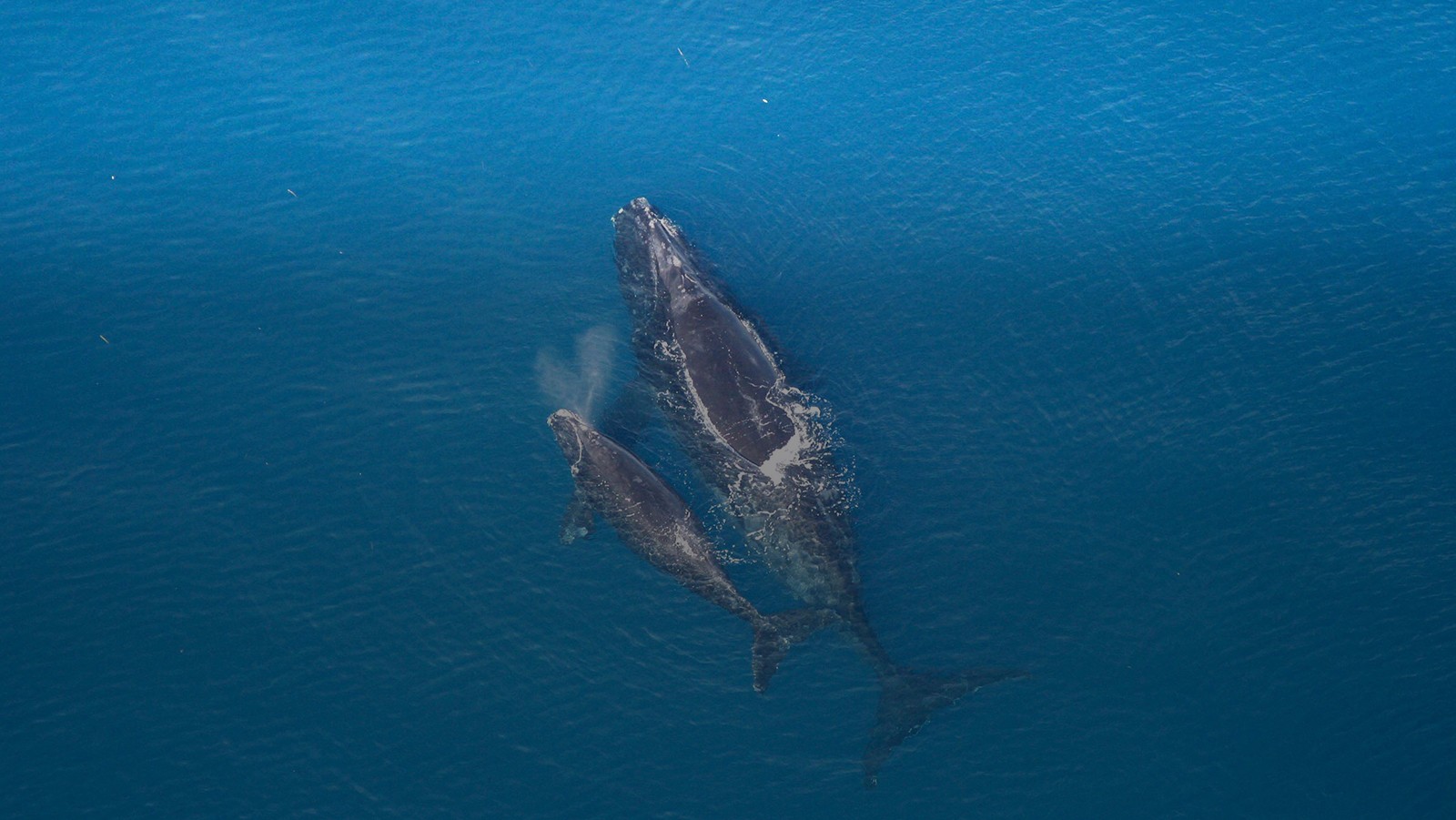
- Improve ship safety and protect endangered Right Whales by reducing the number of ship strikes with the Mandatory Ship Reporting System.
- Improve stock assessment and management of Atlantic Bluefin Tuna by producing tools to monitor changes in favorable habitat areas.
- Conduct research to assess how projected ocean warming may impact future habitat for commercially important fish species.
- Study larval recruitment within the Mesoamerican reef system and the Caribbean to determine the importance of regional connectivity to local fish populations.


Top News
Extreme climate event in North Atlantic may have kicked off Sargassum explosion a decade ago
May 1, 2023
When massive mounds of golden-brown seaweed began piling up on beaches throughout the Caribbean and West Africa in summer of 2011, the question of where it came from probably mattered less to residents and businesses than how they were going to get rid of it. Certainly, few would have connected the Sargassum seaweed invasion to the extremely snowy 2010-11 winter in the eastern United States. But according to a hypothesis proposed by a team of NOAA AOML-led scientists in 2020, the two phenomena share an origin story: an extremely strong and long-lasting shift of the North Atlantic Oscillation into its negative phase back in 2010.


Read More News
Research Impacts & Key Findings
From Successful Mandatory Ship Reporting
From Actionable Fisheries Research and Data Derived from Global Observing Systems
The Atlantic bluefin tuna index can identify suitable habitat for bluefin tuna
The Atlantic bluefin tuna index can identify suitable habitat for bluefin tuna. This proxy larvae index can explain about 58% of the recruitment variability and is currently used to guide NOAA’s interdisciplinary research cruise.
Hope for Atlantic bluefin tuna fisheries in the northern Gulf of Mexico
Research conducted at AOML based on the IPCC AR4 shows that the Loop Current may slow down as much as 25% by the late 21st century, reducing warm water moving into the Gulf from the Caribbean. This could offset projected surface warming, particularly in the northern Gulf of Mexico which is a known spawning ground for Atlantic bluefin tuna.
Ocean Products
Sargassum Inundation Report
Sargassum, a type of floating algae, can inundate coastal areas can cause significant economic, environmental and public health harm. These reports assess the risk of coastal inundation in the Caribbean and Gulf of Mexico regions using the Alternative Floating Algae Index fields generated by the University of South Florida. This tool analyzes areas at 50km (31 miles) per pixel and a, classifies the risk of sargassum inundation.
Bluefin Tuna Index
The Bluefin Tuna Index provides detailed information about bluefin tuna habitat to management bodies to inform decision making. The index tracks favorable habitat for the bluefin tuna in near-real time and is used by NOAA Fisheries in stock assessments. With better-informed catch limits and location information, commercial fishing operations are able to harvest their catch both successfully and sustainably.
Mandatory Ship Reporting System
The Mandatory Ship Reporting system helps reduce ship strike mortality of the North Atlantic Right Whale population, which has struggled to recover from a decreased population despite being a protected species. This reporting system aims to educate merchant mariners on the plight of the right whale, and to provide information about reducing the risk of ship strikes.
Future-Focused Habitat Research
The Atlantic bluefin tuna spawn in the Gulf of Mexico from April to June. While bluefin tuna can tolerate colder waters than other tropical tunas, they are adversely affected by warm waters, and will avoid places with warmer features, such as the Loop Current in the Gulf of Mexico. This research looks at tolerable Atlantic bluefin tuna habitat under several different ocean warming scenarios to study the potential impact of a warming ocean on those fisheries in the Gulf of Mexico.
Sargassum Research
A commonly found floating algae known as “Sargassum” has inundated the coastlines of the tropical Atlantic and Caribbean since 2011. These alga float at the sea surface, where they can aggregate to form large mats in the open ocean. A 2020 study led by researchers at AOML shows how Sargassum entered and flourished in the tropical Atlantic and Caribbean. A tool based on that research, known as the Sargassum Inundation Report (SIR) has been developed to help managers deal with these periodic inundations.
A Sargassum reporting form has been created to help scientists improve Sargassum monitoring and research. The public is invited to fill out the survey below and upload pictures of Sargassum sightings to help scientists understand and improve Sargassum monitoring.
Sargassum Inundation Hypothesis

Sargassum Inundation Report

Sargassum Reporting Form

Sargassum Frequently Asked Questions
General Sargassum Information
Sargassum is a type of floating brown algae, commonly called “seaweed.” These algae float at the sea surface, never attach to the sea floor, and they can aggregate to form large mats in the open ocean.
Historically, the majority of Sargassum aggregated in the Sargasso Sea in the western North Atlantic, with some small amounts found within the Gulf of Mexico and Caribbean Sea. In 2011, the geographic range expanded, and massive amounts of Sargassum moved west into the Caribbean Sea, Gulf of Mexico, and south tropical Atlantic, washing ashore in Florida, Puerto Rico, the US Virgin Islands, and most islands and coastal areas in the Caribbean Sea.
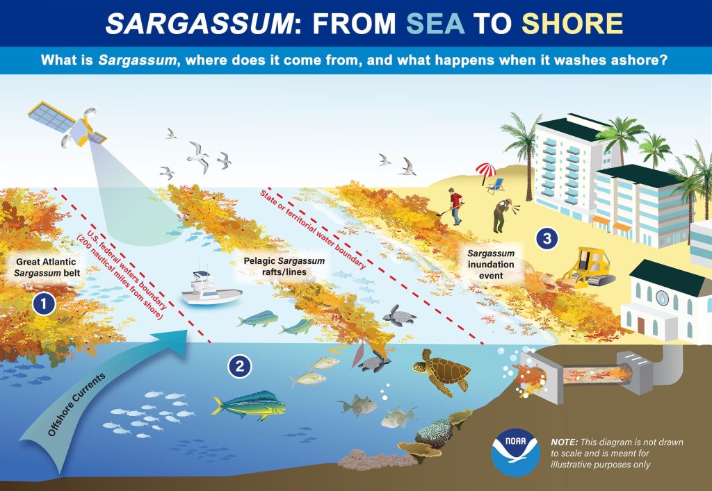
This infographic illustrates the movement of Sargassum from sea to shore. Out at sea, Sargassum provides important fish and wildlife habitat. However, this free-floating algae often washes ashore in great quantities due to strong wind and water currents. Masses of this algae beaching on shore can harm coastal ecosystems, drive away tourists, and pose public health threats. NOAA is working to help coastal communities address the growing problem of what experts call “Sargassum inundation events.” Image credit: NOAA National Ocean Service
Researchers are still assessing various hypotheses about the cause of this first documented extreme event. One hypothesis proposes that during the winter of 2009–2010, the winds that typically blow to the east, from the Americas to Europe, strengthened and shifted to the south more dramatically and persistently than any other time in the 1900–2020 record. This shift in winds triggered a long-distance eastward dispersal of Sargassum, from the Sargasso Sea, toward the Iberian Peninsula in Europe and West Africa. After exiting the Sargasso Sea, the Sargassum drifted southward in the Canary Current and entered the tropics. Once in this new and favorable tropical Atlantic habitat, with ample sunlight, warm waters, and nutrient availability, the Sargassum flourished and has continued to grow.
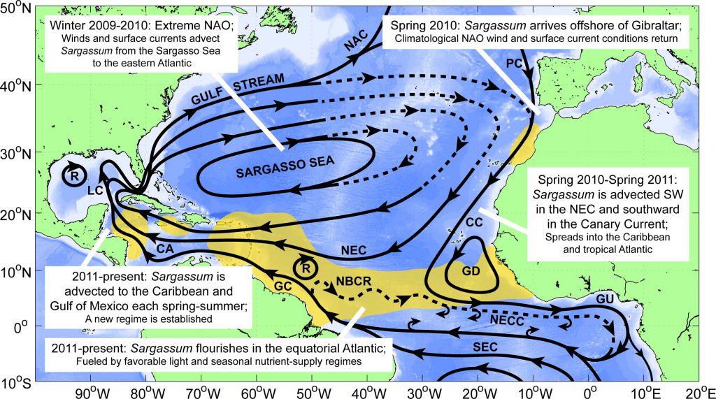
In addition to changing wind patterns, other hypotheses include a combination of factors, such as the variation in the outflow of major rivers (e.g. Amazon and Orinoco), nutrient (nitrogen and phosphorus) concentration in the oceans, increase in the amount of phosphorus due to saharan dust, water temperature, and river runoffs.
Having established a new population, the Sargassum now aggregates almost every year, starting in January/February in a massive windrow or “belt” north of the Equator, along the region where the trade winds converge. During the late winter and early spring months, the Sargassum moves northward with the seasonal winds and currents. By June, this belt may stretch across the entire central tropical Atlantic. Large portions of this algae are then transported into the Caribbean Sea and Gulf of Mexico via the North Equatorial and Caribbean current systems.
Since 2011, large accumulations of Sargassum have occurred every year in the Caribbean Sea, Gulf of Mexico, and tropical Atlantic, but the amount can vary from year to year.
The presence of Sargassum occurs over large areas from the tropical Atlantic in the east, to the Gulf of Mexico in the west, approximately 5,000 kilometers from the eastern tropical Atlantic to the west off the Mexican coast in the Caribbean Sea. Sargassum does not extend as a blanket (or blob) covering the full surface of the ocean in these regions. Instead, Sargassum floats in patches that range in size from a few centimeters to hundreds of meters. Some of these patches reach the coastal areas, including beaches, ports, and even intake systems for drinking water. The area that these patches cover has been significantly larger in recent years than prior to 2011.
Sargassum, in normal amounts, provides habitat, food, protection, and breeding grounds for hundreds of diverse marine species, including commercially important species, such as tuna and swordfish, that feed on the smaller marine life present in Sargassum mats. If Sargassum reaches the coast in small/normal quantities, it may help to avoid beach erosion.
Out at sea, Sargassum is an important habitat for fish, sea turtles, and other marine organisms, but as it accumulates close to the coastlines it can smother valuable corals, seagrass beds, and beaches. As it washes ashore the seaweed begins to decay, attracting flies and other insects. Additionally, during its breakdown, Sargassum produces hydrogen sulfide gas, which smells of rotten eggs, repelling beachgoers and affecting the tourism industry that depends on pristine ocean conditions. Sargassum can also impact navigation, block water intake in desalination plants, and impact benthic ecosystems after/if they sink to the bottom of the ocean.
Studies of the impact of Sargassum on human health started very recently and this is a topic that needs more time to be fully understood. However, when decomposed, Sargassum releases hydrogen sulfide (a gas) that may cause respiratory health problems. Sargassum is also known to often contain heavy metals that can be toxic to humans and animals.
NOAA Efforts
Researchers at NOAA’s AOML and NOAA’s National Environmental Satellite Data, Information Service (NESDIS), and the University of South Florida developed the experimental Sargassum Inundation Report (SIR) to provide an overview of the extent of Sargassum in the ocean and the risk of Sargassum washing into coastal waters, beaches, and shorelines in the Caribbean, Gulf of Mexico, and southeast Florida regions.
Research conducted at AOML in partnership with the University of Miami, the University of South Florida, and LGL Ecological Research (TX) is also aiding to identify how Sargassum extends across the Caribbean, Gulf of Mexico, and tropical Atlantic, by assessing the role of ocean currents, winds, and waves in their motion. This work includes field experiments conducted to monitor the actual path of Sargassum using satellite tracking devices and surface drifters and satellite imagery, and physical representation of Sargassum in theoretical and numerical simulations. Please refer to the end of this FAQ for a list of scientific manuscripts derived from this research.
Additionally, a collaboration between researchers with AOML and Fearless Fund studies how seaweed, including Sargassum, naturally removes carbon dioxide from ocean waters and sequesters it in the seaweed. This project seeks to provide a management solution to wide-scale inundation of beaches, while also repurposing the Sargassum.
As part of NOAA’s RESTORE Science Program, NOAA Fisheries, University of Southern Mississippi, and University of South Florida are evaluating Sargassum‘s role as fish nursery habitat in the northern Gulf of Mexico. This project seeks to understand the relationship with Sargassum distribution and abundance and its capacity to serve as juvenile fish nurseries for recreationally and commercially important species. Results will be used to develop a forecast that can inform fisheries managers of changes in Sargassum and fish recruitment.
Scientists from the University of Rhode Island and Woods Hole Oceanographic Institution are examining the societal impacts of Sargassum inundation events in the Caribbean as part of a study funded by NOAA’s National Centers for Coastal Ocean Science. The three-year long project assesses economic impacts, human well-being, and individual behaviors and perceptions associated with these events, as well as extensive engagement with community members and relevant stakeholders. Results from this study will aid local and regional coastal managers in managing Sargassum inundation events and mitigation activities.
NOAA’s National Centers for Coastal Ocean Science (NCCOS) is initiating a new study to detect and analyze chemical contaminants in Sargassum mats from Puerto Rico, US Virgin Islands, and Florida. Scientists will be looking for concentrations of trace metals, organic, and per- and polyfluoroalkyl substances (PFAS) – many of which are highly persistent – in the samples. This research will provide managers with essential information to safely manage, dispose, repurpose or recycle Sargassum at local jurisdictions.
Further reading:
The experimental Sargassum Inundation Report (SIR) provides an overview of the area of current Sargassum patches and the risk of Sargassum inundation in coastal regions of the Caribbean, tropical Atlantic, and Gulf of Mexico. SIR is an experimental product that updates on a weekly basis and uses satellite-based data to estimate the potential for Sargassum to wash ashore. It is not a forecast.
SIR shows the current conditions of Sargassum density and identifies coastal areas where Sargassum is within 50 km (30 miles) and, therefore, may potentially be impacted by Sargassum in the following days/weeks. The actual occurrence of coastal inundation will largely depend on local current, tide, wind, and wave conditions. The inundation potential is then categorized into three levels: low, medium, and high, which are largely based on the distance between patches of Sargassum to the coast, and the density and extent of these patches. Coastlines are color coded according to these three levels.
SIR serves as a source of information about the present distribution of Sargassum in different areas, potential to reach the coast, and can be used to monitor past movements of Sargassum in the region, which may allow researchers to hypothesize the evolution of the risk in time.
Researchers are using satellite images to identify areas in the open ocean where Sargassum density is large and estimate where beaching events may occur based on the density and proximity of Sargassum patches from the coast. While this is not a forecast, it does help communities prepare for possible inundation events. Researchers are using their knowledge of ocean currents, winds, and wave conditions to improve these estimates.
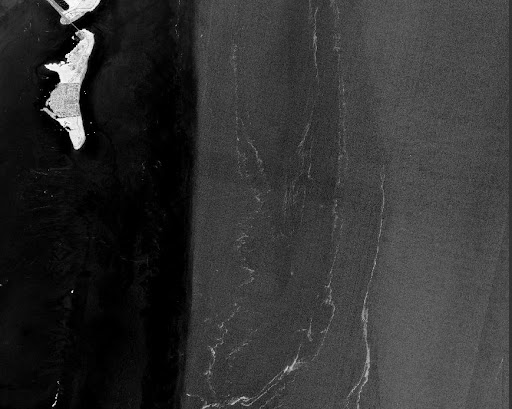
Identifying Sargassum from space is complex. Sargassum can be indirectly observed by satellite from space by measuring how light reflects from the ocean surface.
AOML is conducting research to assess the impact of ocean currents, winds, and waves on the distribution and path of Sargassum, to increase the accuracy of Sargassum pathway models. We also perform monitoring as part of the NOAA NESDIS CoastWatch Caribbean Node hosted at AOML: https://cwcgom.aoml.noaa.gov/cgom/OceanViewer/
Currently SIRs are created from a satellite-derived quantity (density of Sargassum), which is estimated by the University of South Florida using the NASA MODIS (Moderate Resolution Imaging Spectroradiometer) sensor onboard the NASA Aqua and Terra satellites.
Because MODIS is nearing the end of its mission, NOAA CoastWatch and AOML are working towards the upgrade of this product to integrate data from additional sensors to provide better coverage, especially in coastal areas, such as VIIRS on board SNPP, NOAA-20 and NOAA-21 polar orbiting satellite missions, OLCI (Ocean and Land Colour Instrument ) onboard Sentinel-3A and Sentinel-3B satellites, and MSI (Multispectral Instrument) onboard the ESA (European Space Agency) Sentinel-2A and Sentinel-2B optical satellites.
The estimates provided by the SIR have been validated in different areas of the Caribbean Sea and tropical Atlantic Ocean and a publication of this work has been submitted to Elsevier’s Aquatic Botany Journal.
An international citizen science effort to collect mostly coastal observations of Sargassum is led by Florida International University, through the Epicollect Sargassum Watch web pages. Epicollect is a mobile and web application to collect science data. NESDIS CoastWatch and AOML contribute to this effort through its Sargassum citizen science web page located here.
March 2023 Information and Updates
The motion, extent, and density of Sargassum is very complex – it grows, sinks, and moves according to ocean currents, winds, and waves. Therefore, sometimes it may not be possible to describe trajectories in advance, but rather a general description of how the average extension and density have changed. Projecting an accurate path of Sargassum is challenging and a current area of intense research. At this moment, the timing of Sargassum beaching cannot be predicted.
There are two main sources of Sargassum located in the Gulf of Mexico, one is local and peaks in April-May, and the second one is the Caribbean Sea which peaks during the summer months. Large amounts of Sargassum are currently located in the Caribbean Sea, moving towards the Yucatan Peninsula, and spreading through the Gulf of Mexico by the Loop Current.
The Loop Current flows through the Florida Straits and off the east Florida coast, where it is known as the Florida Current, and into the Gulf Stream as it heads north up the eastern coast of the US. The very strong Loop Current is now transporting moderate amounts of Sargassum that were previously located in the Caribbean Sea, with larger amounts potentially on the way. Some of the Sargassum in the Gulf of Mexico also originated locally. Whether the Sargassum will beach on the coast of Florida, including the Florida Keys, will largely depend on the local wind, wave, and tide conditions. Given the complexity of its motion, growth, and decay, it is not possible to forecast the timing of beaching. However, given the size and number of the current Sargassum patches, there is a strong chance that Sargassum carried by the Florida Current may reach the Florida coast despite wind and wave conditions. As of mid March 2023, satellite observations indicate that some of this Sargassum has already reached the northern coast of Cuba.
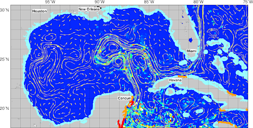
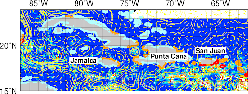
Maps showing Sargassum patches as derived from satellite images and reported weekly through the AOML experimental Sargassum Inundation Report (link)
Sargassum outlooks are published once a month by the University of South Florida. These outlooks show maps with the monthly (past month) extensions of Sargassum. The current (February-March, 2023) total extension of Sargassum in the tropics is similar to the largest events that occurred in previous years (especially 2018), with large extensions of Sargassum observed in the Caribbean Sea being observed since February. While this Sargassum remains at the sea surface and moves with help from ocean currents, winds, and waves, it may grow and increase its density, provided that it encounters warm temperatures and plenty of nutrients. If the large amount of Sargassum that is presently in the Caribbean Sea remains at the surface, it has the potential to spread more widely throughout the Gulf of Mexico and then by the Loop Current and Florida Current (the name of the Gulf Stream off Florida) to reach the Florida Keys and the east Florida coast and Bahamas.
Further Reading
Trinanes, J., N.F. Putman, G. Goni, C. Hu, and M. Wang. (2023). Monitoring pelagic Sargassum inundation potential for coastal communities. Journal of Operational Oceanography, 16(1):48-59, https://doi.org/10.1080/1755876X.2021.1902682
Andrade-Canto, F., F.J. Beron-Vera, G.J. Goni, D. Karrasch, M.J. Olascoaga, and J. Trinanes Carriers of Sargassum and mechanism for coastal inundation in the Caribbean Sea. (2022). Physics of Fluids, 34(1):016602, https://doi.org/10.1063/5.0079055.
Beron-Vera, F.J., M.J. Olascoaga, N.F. Putman, J. Trinanes, G.J. Goni, and R. Lumpkin. (2022). Dynamical geography and transition paths of Sargassum in the tropical Atlantic. AIP Advances, 12(10):105107, https://doi.org/10.1063/5.0117623.
Trinanes, J., C. Hu, N.F. Putman, M.J. Olascoaga, F.J. Beron-Vera, S. Zhang, and G.J. Goni. (2021). An integrated observing effort for Sargassum monitoring and warning in the Caribbean Sea, tropical Atlantic, and Gulf of Mexico. Oceanography 34(4):68-69, https://doi.org/10.5670/oceanog.2021.supplement.02.
Miron, P., M.J. Olascoaga, F.J. Beron-Vera, N.F. Putman, J. Trinanes, R. Lumpkin, and G.J. Goni. Clustering of marine debris- and Sargassum-like drifters explained by inertial particle dynamics. (2020). Geophysical Research Letters, 47(19):e2020GL089874, https://doi.org/10.1029/2020GL089874.
Putman, N., R. Lumpkin, M.J. Olascoaga, J. Trinanes, and G.J. Goni. (2020). Improving transport predictions of pelagic Sargassum. Journal of Experimental Marine Biology and Ecology, 529:151398, https://doi.org/10.1016.j.embe.2020.151398.
Johns, E.M., Lumpkin, R., Putman, N.F., Smith, R.H., Muller‐Karger, F.E., Rueda-Roa, D., Hu, C., Wang, M., Brooks, M.T., Gramer, L.J., & Werner, F.E. (2020). The establishment of a pelagic Sargassum population in the tropical Atlantic: Biological consequences of a basin-scale long distance dispersal event. Progress in Oceanography, 182, 102269. https://doi.org/10.1016/j.pocean.2020.102269
Putman, N.F., G.J. Goni, L.J. Gramer, C. Hu, E.M. Johns, J. Trinanes, and M. Wang. (2018). Simulating transport pathways of pelagic Sargassum from the equatorial Atlantic into the Caribbean Sea. Progress in Oceanography, 165:205-214, https://doi.org/10.1016/j.pocean.2018.06.009.
Finding suitable habitat
The preferred physical environments for Atlantic Bluefin Tuna larvae depend on features in the Gulf of Mexico such as eddies. The proxy larvae index can explain about 58% of the recruitment variability based on the changes in these ocean features, and is currently used to guide NOAA’s interdisciplinary research cruises.
Suitable habitat conditions for bluefin tuna have changed over time. In this tool, red indicates suitable habit and blue is unsuitable (too warm). Dots are observations of bluefin tuna larvae presence. This data tool produces images for download as PNG files. To use the tool, select an image by date below. This index is used by NOAA Fisheries to guide annual Bluefin Tuna larvae sampling surveys, and in support of Bluefin Tuna stock assessments.
Real-time & Delayed-time maps
This tool provides access to real-time as well as delayed-time maps of BFT_Index distribution in the Gulf of Maps starting in 1993, which are used to track favorable areas for occurrence of bluefin tuna (Thunnus thynnus, BFT) larvae.
BFT Spawning in Gulf of Mexico is reported during the Northern Hesmisphere Spring months, with BFT larvae being captured mostly from early-April to late-May. Hence, real-time computation of BFT_Index is provided between March 1st and May 31st of each year.
Real-time Bluefin Index computation period: March 1st – May 31 st
Dates available: 03/01/1993 – Current Spring
Notice: Blank maps indicate that conditions in the Gulf of Mexico are overall unfavorable for occurrence of BFT larvae.
Reducing mortality of the North Atlantic right whale
Collisions with ships (or “strikes”) are a major source of injury and death for the critically endangered North Atlantic right whale. In an effort to reduce the number of ship strikes, NOAA Fisheries and the U.S. Coast Guard, with support from AOML, developed and implemented Mandatory Ship Reporting systems. The systems were endorsed by the International Maritime Organization, a specialized organization of the United Nations.
The Mandatory Ship Reporting System was formally adopted through International Maritime Organization Resolution A.858(20) in December, 1998, and implemented by a USCG Federal Register notice (66 FR 58066). The systems commenced operation on July 1, 1999.
All commercial vessels 300 gross tons and greater are required to report to a shore-based station when entering two designated report areas where right wales are found, including: The waters of Cape Cod Bay, Massachusetts Bay, the Great South Channel, and Stellwagen Bank National Marine Sanctuary along the coast near the Florida/Georgia border.
Reporting ships are required to provide their time and location of entry into the system, speed, and destination – no other aspect of navigation is affected. In return, the ship receives an automated message that provides additional information on how mariners can reduce the likelihood of whale strikes, including recent right whale sighting locations.

Summarized information gathered via the Mandatory Ship Reporting System includes ship traffic volumes, routes, and ports of call, and assists in tailoring any necessary future ship strike reduction measures.
The Mandatory Ship Reporting System is jointly operated and funded by the USCG and NOAA Fisheries, with assistance from NOAA’s Atlantic Oceanographic and Meteorological Laboratory which provides technical support by hosting the software engine, storing and parsing data, and generating statistics on compliance with the Mandatory Ship Reporting System.
The Mandatory Ship Reporting System has received and processed over 20,000 reports from approximately 4,000 distinct commercial vessels. All vessels reporting to the Mandatory Ship Reporting system are provided with a response message containing information on how to avoid collisions with whales, speed limit requirements, and the location of latest whale sightings.
Loop Current effects on fisheries
The fourth Assessment Report of the Intergovernmental Panel on Climate Change (IPCC-AR4) climate model simulations project that the upper ocean in the Gulf of Mexico may increase by more than 2°C by the end of the 21st Century, and suggest that the Gulf of Mexico may become an unsuitable habitat for bluefin tuna spawning due to warmer waters. However, since the IPCC-AR4 models have a very coarse resolution (typically around 100km), the simulated changes in the important factors for the upper ocean temperature response to the changing climate (the strength, position and eddy-shedding characteristics of the Loop Current), are far from realistic.
By zooming in on these features in high resolution models, AOML scientists can look at potential habitat shifts for bluefin tuna in the future. Using this technique, our researchers note that the sea surface temperature increase is much less pronounced in the northern Gulf of Mexico, away from Florida’s west coast. This could be caused by a weakened Loop Current.
AOML scientists predict a 20-25% slowing of this current (based on its larger constituent, the Meridional Overturning Circulation). Also, heat budget analysis for the surface layer indicates this may have a cooling effect, especially in the Northern Gulf of Mexico. The impacts of this to fisheries would be a northward shifting habitat for bluefin tuna.
This research indicates that the area of spawning habitat for the bluefin tuna may not be as drastically reduced as the IPCC-AR4 has projected. AOML researchers will continue their collaboration with NOAA’s Southeast Fisheries Science Center to further refine these projections using additional data and improved ocean modeling techniques.

We are on the forefront of genomics research and applications.
Omics for the Blue Economy.
Omics technology allows researchers to take observations and conduct analysis that help stakeholders and managers make decisions to benefit their customers. With Omics, we can:
- Understand the Microbiome
- Detect Higher Trophic Levels
- Improve Environmental Monitoring
Featured Publication

Joaquin Trinanes, N.F. Putman, G. Goni, C. Hu & M. Wang (2023) Monitoring pelagic Sargassum inundation potential for coastal communities, Journal of Operational Oceanography, 16:1, 48-59, DOI: 10.1080/1755876X.2021.1902682
Abstract: Pelagic Sargassum is a buoyant macroalgae that forms rafts at the ocean surface and serves as a biologically rich habitat for hundreds of diverse marine species. Since 2011, massive blooms of Sargassum have occurred in the tropical Atlantic and swept through the western tropical Atlantic, Caribbean Sea, and Gulf of Mexico. These recurring annual events have caused significant disruptions to coastal communities throughout the region, negatively impacting human health, tourism, fishing, navigation, and nearshore ecosystems. We present here the Sargassum Inundation Report (SIR), a product that uses satellite-based methodology to estimate and predict the future coastal inundation of pelagic Sargassum.
Monitoring pelagic Sargassum inundation potential for coastal communities
Joaquin Trinanes, N.F. Putman, G. Goni, C. Hu & M. Wang (2023) Monitoring pelagic Sargassum inundation potential for coastal communities, Journal of Operational Oceanography, 16:1, 48-59, DOI: 10.1080/1755876X.2021.1902682
Abstract: Pelagic Sargassum is a buoyant macroalgae that forms rafts at the ocean surface and serves as a biologically rich habitat for hundreds of diverse marine species. Since 2011, massive blooms of Sargassum have occurred in the tropical Atlantic and swept through the western tropical Atlantic, Caribbean Sea, and Gulf of Mexico. These recurring annual events have caused significant disruptions to coastal communities throughout the region, negatively impacting human health, tourism, fishing, navigation, and nearshore ecosystems. We present here the Sargassum Inundation Report (SIR), a product that uses satellite-based methodology to estimate and predict the future coastal inundation of pelagic Sargassum.

Publications & References
2023
Trinanes, J., N.F. Putman, G. Goni, C. Hu, and M. Wang. Monitoring pelagic Sargassum inundation potential for coastal communities. Journal of Operational Oceanography, 16(1):48-59 (https://doi.org/10.1080/1755876X.2021.1902682) (2023).2022
Andrade-Canto, F., F.J. Beron-Vera, G.J. Goin, D. Karrasch, M.J. Olascoaga, and J. Trinanes. Carriers of Sargassum and mechanism for coastal inundation in the Caribbean Sea. Physics of Fluids, 34(1):016602 (https://doi.org/10.1063/5.0079055) (2022).Kavanaugh, M.T., T. Bell, D. Catlett, M.A. Cimino, S.C. Doney, W. Klajbor, M. Messié, E. Montes, F.E. Muller-Karger, D. Otis, J.A. Santora, I.D. Schroeder, J. Trinanes and D.A. Siegel. Satellite remote sensing and the Marine Biodiversity Observation Network: Current science and future steps. Oceanography, 34(2):62-79 (https://doi.org/10.5670/oceanog.2021.215) (2021).
Trinanes, J., C. Hu, N.F. Putman, M.J. Olascoaga, F.J. Beron-Vera, S. Zhang, and G.J. Goni. An integrated observing effort for Sargassum monitoring and warning in the Caribbean Sea, tropical Atlantic, and Gulf of Mexico. 34(4):68-69 (https://doi.org/10.5670/oceanog.2021.supplement.02-26) (2021).
2021
Baker-Austin, C., J. TRINANES, and J. Martinez-Urtaza. The new tools revolutionizing Vibrio science. Environmental Microbiology, 22(10):4096-4100 (https://doi.org/10.1111/1462-2920-15083) (2020).Jiang, L.-Q., R.A. Feely, R. Wanninkhof, D. Greeley, L. Barbero, S. Alin, B.R. Carter, D. Pierrot, C. Featherstone, J. HOOPER, C. Melrose, N. Monacci, J.D. Sharp, S. Shellito, Y.-Y Xu, A. Kozyr, R.H. Byrne, W.-J. Cai, J. Cross, G.C. Johnson, B. Hales, C. Langdon, J. Mathis, J. Salisbury, and D.W. Townsend. Coastal Ocean Data Analysis Product in North America (CODAP-NA)—An internally consistent data product for discrete inorganic carbon, oxygen, and nutrients on the North American ocean margins. Earth System Science Data, 13(6):2777-2799 (https://doi.org/10.5194/essd-13-2777-2021) (2021).
Kearney, K.A., S.J. Bograd, E. Drenkard, F.A. GOMEZ, M. Haltuch, A.J. Hermann, M.G. Jacox, I.C. Kaplan, S. Koenigstein, J.Y. Luo, M. Masi, B. Muhling, M. Pozo Buil, and P.A. Woodworth-Jefcoats. Using global scale earth-system models for regional fisheries applications. Frontiers in Marine Science, 8:622206 (https://doi.org/10.3389/fmars.2021.622206) (2021).
Miron, P., M.J. Olascoaga, F.J. Beron-Vera, N.F. Putman, J. TRINANES, R. LUMPKIN, and G.J. GONI. Clustering of marine debris- and Sargassum-like drifters explained by inertial particle dynamics. Geophysical Research Letters, 47(19):e2020GL089874 (https://doi.org/10.1029/2020GL089874) (2020).
Trinanes, J., and J. Martinez-Urtaza. Future scenarios of risk of Vibrio infections in a warming planet: A global mapping study. The Lancet Planetary Health, 5(7):E426-E435 (https://doi.org/10.1016/S2542-5196(21)00169-8) (2021).
Valle-Levinson, A., V.H. Kourafalou, R.H. Smith and Y. Androulidakis. Flow structures over mesophotic coral ecosystems in the eastern Gulf of Mexico. Continental Shelf Research, 207:104219 (https://doi.org/10.1016/j.csr.2020.104219) (2020).
2020
Androulidakis, Y., V. Kourafalou, L.R. Hole, M. LE HENAFF, and H.-S. Kang. Pathway of oil spills from potential offshore Cuban exploration: Influence of ocean circulation. Journal of Marine Science and Engineering, 8(7):535 (https://doi.org/10.3390/jmse8070535) (2020).Frys, C., A. Saint-Amand, M. LE HÉNAFF, J. Figueiredo, A. Kuba, B. Walker, J. Lambrechts, V. Vallaeys, D. Vincent, and E. Hanert. Fine-scale coral connectivity pathways in the Florida Reef Tract: Implications for conservation and restoration. Frontiers in Marine Science, 7:312 (https://doi.org/10.3389/fmars.2020.00312) (2020).
JOHNS, E.M., R. LUMPKIN, N.F. Putman, R.H. SMITH, F.E. Muller-Karger, D. Rueda-Roa, C. Hu, M. Wang, M.T. Brooks, L.J. Gramer, and F.E. Werner. The establishment of a pelagic Sargassum population in the tropical Atlantic: Biological consequences of a basin-scale long distance dispersal event. Progress in Oceanography, 182:102269 (https://doi.org/10.1016/j.pocean.2020.102269) (2020).
LE HÉNAFF, M., F.E. Muller-Karger, V.H. Kourafalou, D. Otis, K.A. Johnson, L. McEachron, and H.-S. Kang. Coral mortality event in the Flower Garden Banks of the Gulf of Mexico in July 2016: Local hypoxia due to cross-shelf transport of coastal flood waters? Continental Shelf Research, 190:103988 (https://doi.org/10.1016/j.csr.2019.103988) (2019).
Putman, N., R. LUMPKIN, M.J. Olascoaga, J. TRINANES, and G.J. GONI. Improving transport predictions of pelagic Sargassum. Journal of Experimental Marine Biology and Ecology, 529:151398 (https://doi.org/10.1016/j.jembe.2020.151398) (2020).
Wanninkhof, R., J. TRINANES, G.-H. Park, D. Gledhill, and A. Olsen. Large decadal changes in air-sea CO fluxes in the Caribbean Sea. Journal of Geophysical Research-Oceans, 124(10):6960-6982 (https://doi.org/10.1029/2019JC015366) (2019).
Wanninkhof, R., D. Pierrot, K. Sullivan, L. Barbero, and J. TRINANES. A 17-year dataset of surface water fugacity of CO2 along with calculated pH, aragonite saturation state, and air-sea CO2 fluxes in the northern Caribbean Sea. Earth System Science Data,12(3):1489-1509 (https://doi.org/10.5194/essd-12-1489-2020) (2020).
2018
Putman, N.F., Goni, G., Gramer, L., Hu, C., Johns, E., Trinanes, J. and Wang, M., 2018: Simulating transport pathways of pelagic Sargassum from the Equatorial Atlantic into the Caribbean Sea. Progress in Oceanography, 165:205-214 (doi:10.1016/j.pocean.2018.06.009).2017
Muhling, B. A., R. Brill, J. T. Lamkin, M. A. Roffer, S.-K. Lee, Y. Liu, and F. Muller-Karger, 2017: Projections of future habitat use by Atlantic bluefin tuna: mechanistic vs. correlative distribution models. ICES. J. Marine Science, 74(3):698-716 (doi:10.1093/icesjms/fsw215).Carrillo,L., J.T. Lamkin, E.M. Johns, L. Vasquez-Yeomans, F. Sosa-Cordero, E. Malca, R.H.Smith, and T. Gerard, 2017: Linking oceanographic processes and marine resources in the western Caribbean Sea Large Marine Ecosystem subarea. Elsevier, Environmental Development, 22:84-96 (doi:10.1016/j.envdev.2017.01.004).
2016
Domingues, R., G. Goni, F. Bringas, B. Muhling, D. Lindo-Atichati, and J. Walter (2016). Variability of preferred environmental conditions for Atlantic bluefin tuna (Thunnus thynnus) larvae in the Gulf of Mexico during 1993-2011. Fisheries Oceanography, 25(3): 320-336.Carrillo, L., E. M. Johns, R. H. Smith, and J.T. Lamkin, 2016: Pathways and hydrography in the Mesoamerican Barrier Reef System, Part 2: Thermohaline structure. Cont. Shelf Res., 120, 41-58, (doi:10.1016/j.csr.2016.03.014).
Lee, T.N., N. Melo, N. Smith, E.M. Johns, C.R. Kelble, R.H. Smith, and P.B. Ortner, 2016: Circulation and water renewal of Florida Bay. Bull. Am. Meteorol. Soc., 92(2):153-180, (doi:10.5343/bms.2015.1019).
2015
Karnauskas, M., M.J. Schirripa, J.K. Craig, G.S. Cook, C.R. Kelble, J.J. Agar, B.A. Black, D.B. Enfield, D. Lindo-Atichati, B.A. Muhling, K.M. Purcell, P.M. Richards, and C. Wang, 2015: Evidence of climate-driven ecosystem reorganization in the Gulf of Mexico. Global Change Biology, 21(7):2554-2568, (doi:10.1111/gcb.12894).Muller-Karger, F.E., J.P. Smith, S. Werner, R. Chen, M. Roffer, Y. Liu, B. Muhling, D. Lindo-Atichati, J. Lamkin, S. Cerdeira-Estrada, and D.B. Enfield, 2015: Natural variability of surface oceanographic conditions in the offshore Gulf of Mexico. Prog. in Oceanogr., 134:54-76, (doi:10.1016/j.pocean.2014.12.007.)
Muhling, B.A., Y. Liu, S.-K. Lee, J.T. Lamkin, M.A. Roffer, F. Muller-Karger, and J.W. Walter, 2015: Potential impact of climate change on the Intra-Americas Seas: Part 2: Implications for Atlantic bluefin tuna and skipjack tuna adult and larval habitats. J. Mar. Syst., 148:1-13, (doi:10.1016/j.marsys.2015.01.010).
Carrillo, L., E. M. Johns, R. H. Smith, J. T. Lamkin, and J. L. Largier, 2015: Pathways and hydrography in the Mesoamerican Barrier Reef System Part 1: Circulation. Continental Shelf Research, 109:164-176, (doi:10.1016/j.csr.2015.09.014).
2012
Lindo-Atichati, D., Bringas, F., Goni, G., Muhling, B., Muller-Karger, F.E. and Habtes, S. (2012) Varying mesoscale structures influence larval fish distribution in the northern Gulf of Mexico. Mar. Ecol. Prog. Ser. 463:245-257.Lindo-Atichati, D.,F. Bringas, G.J. Goni, B. Muhling, F.E. Muller-Karger and S. Habtes, 2012: Varying mesoscale structures influence larval fish distribution in the northern Gulf of Mexico. Mar. Ecol. Progr. Series, 463:245-257, doi:10.3354/meps09860.
2011
Muhling, Barbara A., J. T. Lamkin, J. M. Quattro, R. H. Smith, M. A. Roberts, M. A. Roffer, and K. Ramirez, 2011: Collection of larval bluefin tuna (Thunnus thynnus) outside documented western Atlantic spawning grounds. Bull. Mar. Sci., 87(3):687-694.Muhling, B. A., S.-K. Lee, J. T. Lamkin, and Y. Liu, 2011: Predicting the Effects of Climate Change on Bluefin Tuna (Thunnus thynnus) Spawning habitat in the Gulf of Mexico. ICES. J. Mar. Sci., 68(6):1051-1062, doi:10.1093/icesjms/fsr008.
2010
Muhling, B.A., Lamkin, J.T. and Roffer, M.A. (2010) Predicting the occurrence of Atlantic bluefin tuna (Thunnus thynnus) Fish. Oceanogr.Preferred environmental conditions for Atlantic bluefin tuna larvae larvae in the northern Gulf of Mexico: building a classification model from archival data. Fish Oceanogr. 2(19):526-539.
Looking for Literature? Search our Publication Database.