Integrated Ecosystem Assessments
Balancing the needs of nature and society through integrated science for current and future generations
OR SCROLL TO LEARN MORE
Introduction
The National Oceanic and Atmospheric Administration (NOAA) Integrated Ecosystem Assessments (IEA) are an approach to Ecosystem-Based Management. This approach integrates all components of an ecosystem, including humans, into the decision-making process so that managers can balance trade-offs and determine what is more likely to achieve their desired goals. The approach is a NOAA wide, inter-line office initiative, that provides a consistent national approach but is flexible to accommodate regional needs. It is overseen by the IEA program, which directs the execution of Integrated Ecosystems Assessments within five regions in the United States ocean and coastal ecosystems.
The goal of NOAA’s IEA program is to provide the products that will enable resource managers to make better science-based decisions using a holistic, integrated ecosystem approach. Observations, empirical analyses, and ecosystem modeling are used to better understand complex coastal ecosystems and their response to the countless natural and anthropogenic pressures they currently face. This understanding allows us to predict and evaluate the ecosystem response to potential management actions, thus helping resource managers to make decisions in a holistic, integrated ecosystem approach rather than evaluating, in isolation, the response of a single ecosystem sector.
The IEA region co-led by AOML is the Gulf of America IEA. There are three current focus areas as well as a full regional integrated ecosystem assessment through which our team is balancing the needs of nature and society through integrated science for current and future generations of the Gulf of America:
- Ecosystem Support for Fisheries
- Red Tide Community Resilience
- Florida Keys National Marine Sanctuary
Our mission is to provide the products needed to inform ecosystem-based management decisions so that resource managers can use a method that is holistic and considers the entire integrated ecosystem, rather than just considering individual species in isolation. Our goal is to provide useful scientific information that can improve decision-making in resource management and considers the human dimension and its ecological impacts. This understanding allows us to predict and evaluate the ecosystem response to potential management actions.
Who We Are


Top News
NOAA cruises set the foundation for restoring crucial Florida ecosystems
March 28, 2025
South Florida is comprised of 350 miles of the only barrier coral reef in North America – and the third largest in the world. 1,800 miles of shoreline is lined with mangroves in the Florida Keys alone, which provide coastal protection from storms and support juveniles of commercialized fish species. The region sustains the largest […]
Read More News
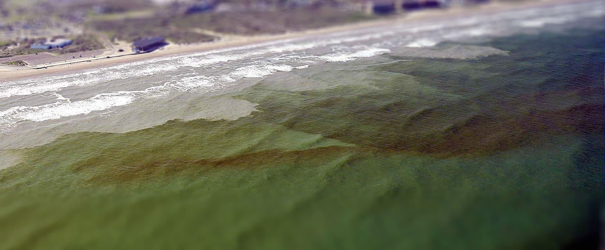
 100,000 cells per liter) are present in the water. K. brevis produces toxins called brevetoxins that can cause massive fish kills, weaken or kill marine mammals, and (if the toxin becomes aerosolized and inhaled) cause respiratory distress in humans and marine mammals. The team of scientists will be comprehensively sampling a series of transects along the West Florida Shelf." loading="lazy">
 100,000 cells per liter) are present in the water. K. brevis produces toxins called brevetoxins that can cause massive fish kills, weaken or kill marine mammals, and (if the toxin becomes aerosolized and inhaled) cause respiratory distress in humans and marine mammals. The team of scientists will be comprehensively sampling a series of transects along the West Florida Shelf." loading="lazy">
Increasing Red Tide Sampling off the West Florida Shelf
Stewards of a cleaner, healthier, more sustainable ocean.
Marine Sanctuaries.
The Florida Keys National Marine Sanctuary, part of the National Marine Sanctuary system of underwater parks, protects 2,900 square nautical miles encompassing the continental United States’ only coral barrier reef, seagrass beds, mangrove islands, and more than 6,000 marine life species. Home to world-class diving and fishing, the highly-diverse and sensitive marine ecosystem drives the economy and local way of life. The Florida Keys National Marine Sanctuary faces many challenging management issues such as coral disease, invasive species, marine debris and, increasingly, human impact.
NOAA’s IEA program partners with the Office of National Marine Sanctuaries to advance the science behind Sanctuary condition reports and management plans.
Read More
The Integrated Ecosystem Assessment approach combines all components of an ecosystem, including humans, into the decision-making process so that managers can determine what is more likely to achieve their desired goals. After identifying management priorities, the next step in the Florida Keys Integrated Ecosystem Assessment was to identify ecological and socioeconomic indicators that will inform the Florida Keys National Marine Sanctuary managers of the health of the sanctuary.
An Indicator Selection Workshop was held in September 2018 in Key Largo, Florida, to garner expert opinion, advice, and feedback for selection of proposed ecological and socioeconomic indicators on the health of the Florida Keys National Marine Sanctuary. Policy, academic, and resource management experts who do work in the region provided input. This resulted in a scored and prioritized suite of indicators. The time series status and trends of this suite of indicators were analyzed.
These indicators will be used to identify and quantify thresholds of acceptable ecosystem change resulting from pressures to the system. This information can help set management targets, provide interdisciplinary best science to Sanctuary managers, and will inform the next Sanctuary Condition Report and the next management review process. Florida Keys Integrated Ecosystem Assessment Human Use Indicators presentation to the Sanctuary Advisory Council in June 2019.

Supporting the needs of NOAA and Line Offices.
Ecosystem Assessments.
Our research supports the needs of the broader NOAA organization and Line Offices, as well as our stakeholders.
In May of 2018, the Gulf of America Integrated Ecosystem Assessment team met with the Florida Keys National Marine Sanctuary staff to understand their science and management priorities and initiate the Integrated Ecosystem Assessment process for the Florida Keys.
View the Interactive Florida Keys Integrated Ecosystem Assessment Report Page
We recently launched a report page to communicate research conducted during the Integrated Ecosystem Assessment for the Florida Keys. Click the button below to visit the report.
Red Tide Community Resilience
In the Gulf of America, some harmful algal blooms are caused by the rapid growth of the microscopic algae species Karenia brevis, commonly called red tide. Red tide can cause respiratory illness and eye irritation in humans, can contaminate seafood, and can also kill marine life. While these are naturally occurring events, the 2018 event was worse than usual, leading to massive die-offs of marine species, economic losses for coastal businesses, and possible respiratory symptoms in humans.
Since the late 1990s, the Atlantic Oceanographic and Meteorological Laboratory’s Ecosystem Assessment research group has been conducting a series of bimonthly cruises aboard the R/V Walton Smith investigating the coastal water quality in South Florida. Starting in October 2018, the cruises were enhanced and modified to better capture the response of south Florida coastal water quality to the effect of red tide events occurring in the southwest Florida shelf.
Studying Impacts of Red Tide
During a series of late summer 2018 workshops with stakeholders on the southwest Florida coast, serious concerns were highlighted regarding the impacts of red tide not only on fish populations, but also on the habitat, the commercial and for-hire fishing businesses, aquaculture, tourism and human health. Stakeholders have observed extensive habitat damage related to red tide, and have noted that recovery of fish populations has been increasingly delayed following recent red tides. A number of human health impacts were noted, including the direct effects of the Karenia brevis toxin as well as other bacterial infections which may be related to other pathogens associated with the bloom. Red tides are impacting not only the fish populations that commercial and for-hire fishing businesses are dependent upon, but other aspects of the fishing communities such as aquaculture activities, private recreational fishing, tourism visitation, local seafood markets, and real estate values. Through these additive and potentially synergistic effects, red tides can have far-reaching impacts on coastal communities. For more information about the effects of red tide, visit the NOAA’s National Ocean Service red tide page.
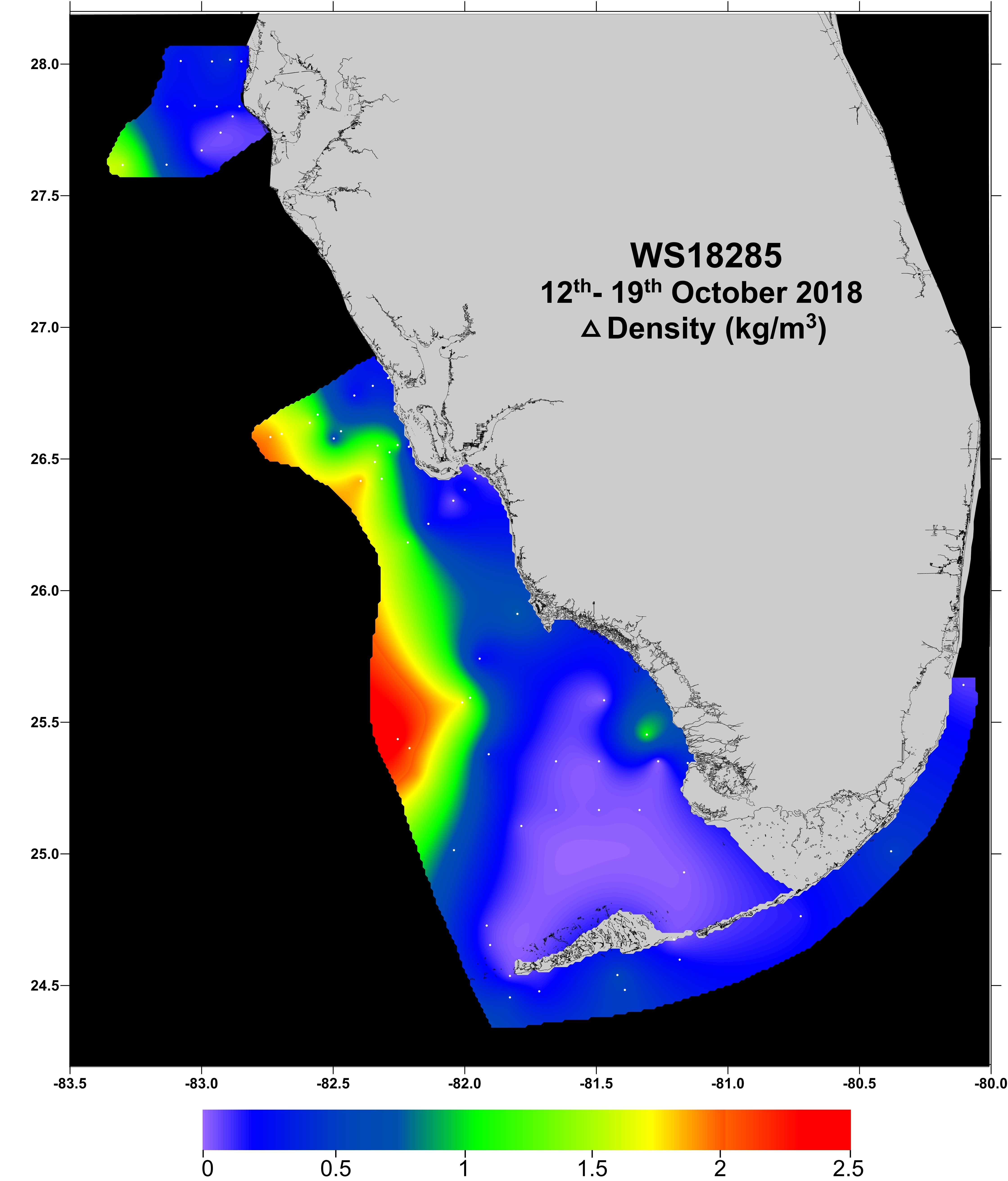
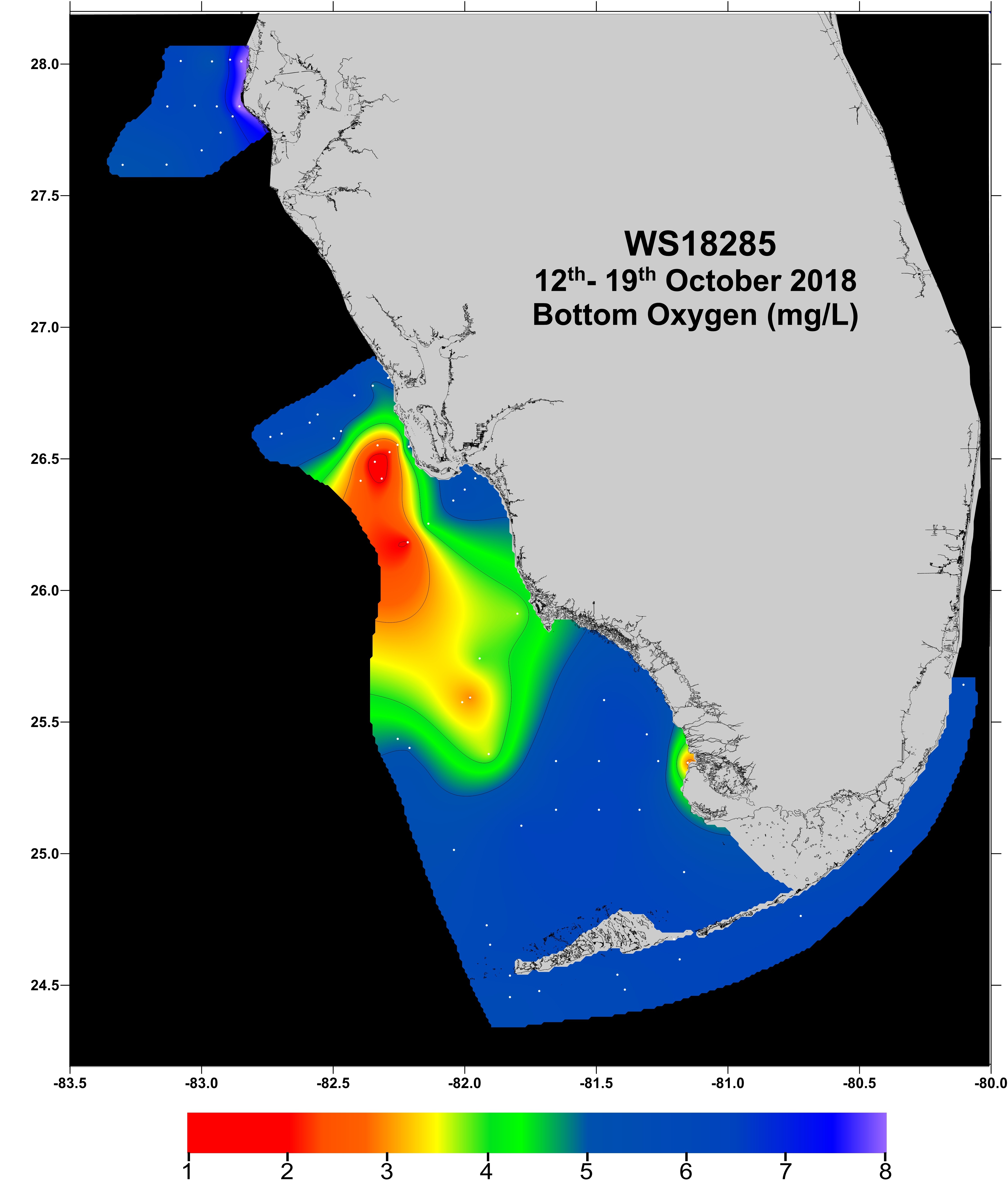
Red Tide Water Quality Assessment Research Cruise
R/V Walton Smith Cruise 18285 – October 12– 19, 2018
AOML scientists led a multi-agency research cruise aboard the R/V Walton Smith in October 2018 to study the effects of southwest Florida’s on-going red tide. The cruise brought together a diverse team of experts from federal, state and academic institutions, as well as private industry.
Off the coast of Charlotte Harbor near Sanibel Island, scientists found a subsurface bloom that was most intense deeper in the water column at about 10‑15 m below the ocean surface. The water column sampled in this region was highly stratified, and the bloom was found at the boundary of colder, saltier, low-oxygen water on the bottom and warmer, fresher, normal-oxygen water on the surface. Off the coast of Tampa Bay, researchers found a red tide bloom near the ocean surface where the waters were less stratified and no low-oxygen layer was present. However, there were fish kills in this area which were not found in Charlotte Harbor.
We are strong because of our community.
Engaging Citizen Science.
The Florida Commercial Watermen’s Conservation plan established a fishermen water quality monitoring program on the southwest Florida shelf. Fishermen have a vested interest in ensuring the health of this region and making their communities more resilient to future harmful algal blooms, while scientists need sustained 4-dimensional monitoring of the water column on the west Florida shelf to better understand red tides and other algal blooms. Commercial fishermen frequently transect the west Florida shelf while in transit to their fishing grounds. By providing fishermen with robust scientific instruments and an easy method to download and transmit the data to scientists, we can accomplish the objectives of both fishermen and scientists while simultaneously providing a number of other benefits to both communities.
The goal of the program is to quantify the environmental and oceanographic conditions before, during, and after red tide blooms to better understand their dynamics and provide timely decision-support to increase the resilience of fishermen and fishing communities on the west coast of Florida to red tide events. For more information about the Florida Commercial Watermen’s Conservation program, visit the Florida Watermen.org web page.

Producing Actionable Research
Ecosystem Support for Fisheries
The Gulf of America Integrated Ecosystem Assessment (GoM-IEA) is a wide-ranging collaboration within NOAA and with outside NOAA partners in the Gulf of America region, aiming to fulfill the needs of resource managers for science-based decision making tools. As the provider of many life-sustaining services, the sea and its diverse ecosystems are of extreme importance to humans. Benefits derived from coastal areas include providing food, avenues for transportation, protection from storms and a multitude of others termed “ecosystem services.”
The objective of the Gulf of America Integrated Ecosystem Assessment is to investigate the tradeoffs among and between services and sustainability using cross-sectoral analyses. Through the development of qualitative, semi-quantitative, and dynamic holistic ecosystem models and methodologies, the Gulf of America Integrated Ecosystem Assessment hopes to help inform management decisions and aim to minimize the risk to ecosystem services and sustainability. This project is part of a worldwide movement towards Ecosystem Based Management (EBM) as the approach to safeguard marine ecosystems and their services. As coastal populations continue to grow, the demand for accessibility to these benefits is increasing. In order to sustain ecosystem services, it is important to first understand and protect the environments from which they are derived.
To learn more, visit the Gulf of America Ecosystems Status Report.

To learn more, visit NOAA’s Gulf of America Integrated Ecosystem Assessment page.