Western Boundary Time Series
Monitoring the Western Boundary Currents in the Subtropical Atlantic
JUMP TO DATA
SCROLL TO LEARN MORE
Who We Are
What We Do
The Western Boundary Time Series (WBTS) project conducts sustained monitoring of the volume transport and seawater properties of the western boundary currents in the subtropical North Atlantic. These include the Florida Current, as it flows northward through the Straits of Florida; as well as the near-surface northward-flowing Antilles Current and the southward-flowing Deep Western Boundary Current (DWBC), both of which are located east of the Bahamas.
The WBTS project consists of two components:
1. Measurements of the Florida Current volume transport at about 27ºN with a submarine telephone cable supplemented with regular (14-16 times per year) calibration cruises that also observe changes in seawater properties;
2. Measurements of seawater properties and meridional flows across the 26.5ºN transect to the east of the Bahamas Islands with dedicated regular (approximately every 9 months) hydrographic surveys and an array of moorings.
Objectives of the Western Boundary Time Series project:
- Monitor the volume transport of the Florida Current.
- Observe changes in water mass properties in the Straits of Florida.
- Monitor the near-surface Antilles Current and the Deep Western Boundary Current, and associated water mass properties.
- Serve as a western boundary endpoint of a subtropical meridional overturning circulation/heat transport monitoring system at about 26.5ºN established in 2004 in partnership with the University of Miami and the National Oceanographic Centre (United Kingdom).

Denis Volkov
Co-Principal Investigator

Pedro Pena
Field Operations and Engineering Support

Ian Smith
Science Diver

Ryan Smith
Co-Principal Investigator

Andrew Stefanick
Field Operations and Engineering Support

Jay Hooper
Data Management

Christian Saiz
Field Operations and Engineering Support

Rigoberto Garcia
Data Management

Christopher Garcia
Field Operations and Engineering Support

Ulises Rivero
Field Operations and Engineering Support

Leah Chomiak
Science Diver
Top News
Ocean Month: Exploring and understanding our ocean through research cruises
June 25, 2025
Research cruises are essential for scientists to collect data, deploy instrumentation, and maintain ocean observing systems. NOAA regularly conducts research at sea to study the ocean and atmosphere, advancing our understanding of the ocean, monitoring ocean conditions, and ensuring sustainable fisheries and healthy marine habitats. These expeditions provide essential data for weather prediction, ocean acidification […]


Read More News
Research Impacts & Key Findings
WBTS and project partners have conducted more than 110 hydrographic cruises, measuring water mass properties and transport, across the project focus area, which includes the Florida Straits, Northwest Providence Channel, and along 26.5N east of Abaco Island, Bahamas. These hydrographic measurements allow project scientists to monitor the Florida Current, the Antilles Current, and the Deep Western Boundary current (all important western boundary currents in the North Atlantic Ocean) for changes over multiple time scales.
In the Florida Straits at 27N, AOML has conducted more than 14,000 daily estimates of the Florida Current transport since 1982, has led 252+ dropsonde cruises since 1991, 110+ XBT cruises since 1998, and 106+ CTD/ADCP surveys since 2001.
Background
The Meridional Overturning Circulation
Climate models have shown that variations of the transport of the Meridional Overturning Circulation (MOC) in the Atlantic Ocean have significant impacts on the climate at both the regional and global level. In the subtropical North Atlantic, the MOC consists primarily of two western boundary components: the northward flowing Gulf Stream/ Florida Current and the southward flowing Deep Western Boundary Current.
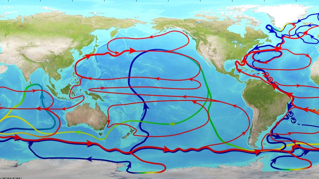
The Importance of the Western Boundary Currents
Western boundary currents are some of the strongest ocean currents in the world, carrying with them large amounts of heat, fresh water, nutrients and other chemicals that alter the global and regional weather, climate, sea level, and marine ecosystem. The WBTS project addresses NOAA’s mission to observe, understand, and predict changes in climate, weather, oceans, and coasts by carrying out sustained time series measurements of the western boundary currents in the subtropical North Atlantic.
What is the Western Boundary Time Series Project?
The WBTS project continuously monitors two important components of the thermohaline circulation in the subtropical North Atlantic with the ultimate goal of determining the state of the overturning circulation and providing a monitoring system for rapid climate change. The components are the northward flowing Florida Current and the southward flowing Deep Western Boundary Current: both key components of the meridional overturning circulation (MOC) in the subtropical North Atlantic. Over the past 30+ years the program has worked to measure both the warm upper and cold lower limbs of the MOC near the western boundary of the Atlantic Ocean at 27°N and is the longest time series of the flow that makes up the MOC available globally.
History of the WBTS project
The earliest observations of the total Florida Current transport in the northern Straits of Florida were made with dropsonde measurements between 1964 and 1974. Submarine telephone cable use for the estimates of the Florida Current transport dates back to 1975-1979.
In the modern era (2000-present) the cable measurements and hydrographic surveys in the Straits of Florida and east of Abaco are now part of the NOAA Western Boundary Time Series program.
Check out the Western Boundary Time Series project timeline.
The Western Boundary Time Series Project

Methodology
Scientists at AOML use a decommissioned submarine telephone cable, along with calibration cruises, full water column hydrographic surveys, and moored observations to monitor the Atlantic’s western boundary currents and seawater properties.
Hydrographic cruises are conducted approximately every 9 months across the Deep Western Boundary Current (DWBC) area east of Abaco Island to measure water mass properties and transports. Tracer sampling, such for chlorofluorocarbon (CFC) and carbon dioxide (CO2), are also present in many sections.
The repeated hydrographic and tracer sampling at Abaco has established a high-resolution record of water mass properties in the Deep Western Boundary Current at 26N. This data set is unique because it is a transport section of a single time series site, of which very few are available in the ocean that approach a decade in length.

Sampling Instruments
Submerged Telephone Cables
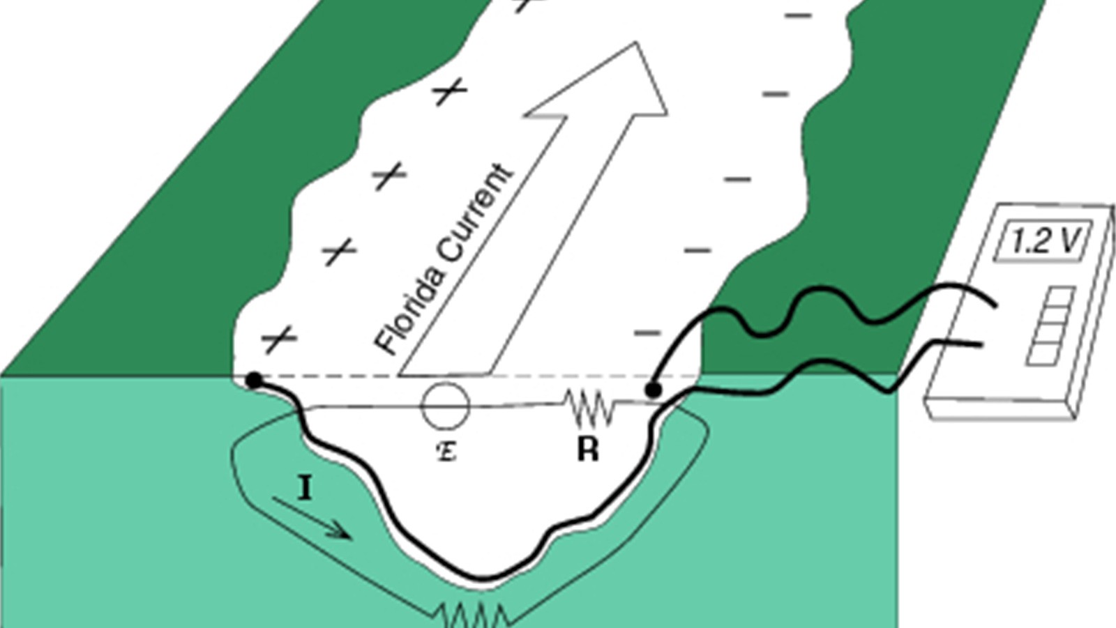
The Florida Current transports are collected by measuring the voltage difference across the Straits of Florida using submerged submarine telephone cables. The cable measurements have provided a daily transport time series since 1982. When ions in seawater are advected by ocean currents through the magnetic field of the Earth, an electric field is produced perpendicular to the direction of the water motion. Submarine cables provide a means for measuring these “motionally-induced” voltages in the ocean. Using the voltages induced on the cables, the full-water-column transports across the cable can be estimated.
Inverted Echo Sounders (IES)
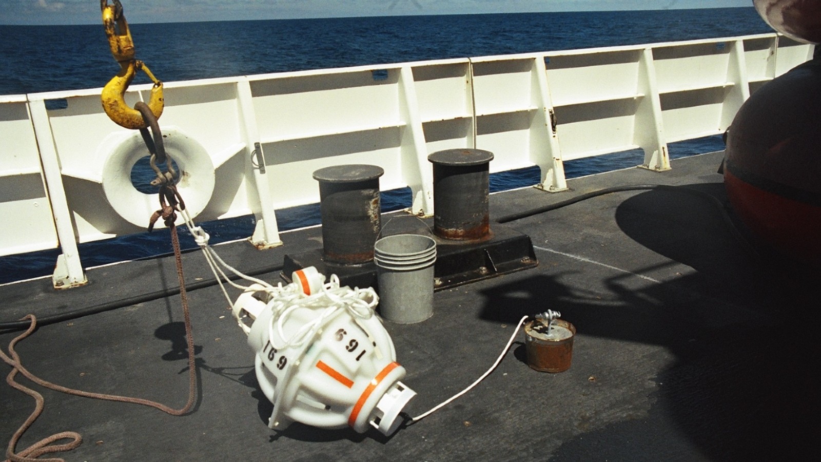
An Inverted Echo Sounder (IES) measures average sound speed in the water column by sending out a series of 24 10kHz or 12kHz sound pulses each hour. The IES records the amount of time between when each pulse is sent out and when the pulse is heard returning to the IES. The travel time combined with other ocean measurements estimates full-water-column profiles of temperature, salinity, and density. The IES can be additionally equipped with bottom pressure gauges (PIES) and deep current meters (C-IES). Data from these instruments are acoustically downloaded by a passing research vessel about every 6 months without actually recovering the instruments.
CTD/ LADCP
CTD stands for conductivity, temperature, and depth, and refers to a package of electronic instruments that measure these properties. A CTD device’s primary function is to detect how the conductivity and temperature of the water column changes relative to depth. Lowered acoustic Doppler current profilers (LADCP) measure water currents with sound, using a principle of sound waves called the Doppler effect. Scientists use the instrument to measure how fast water is moving across an entire water column.
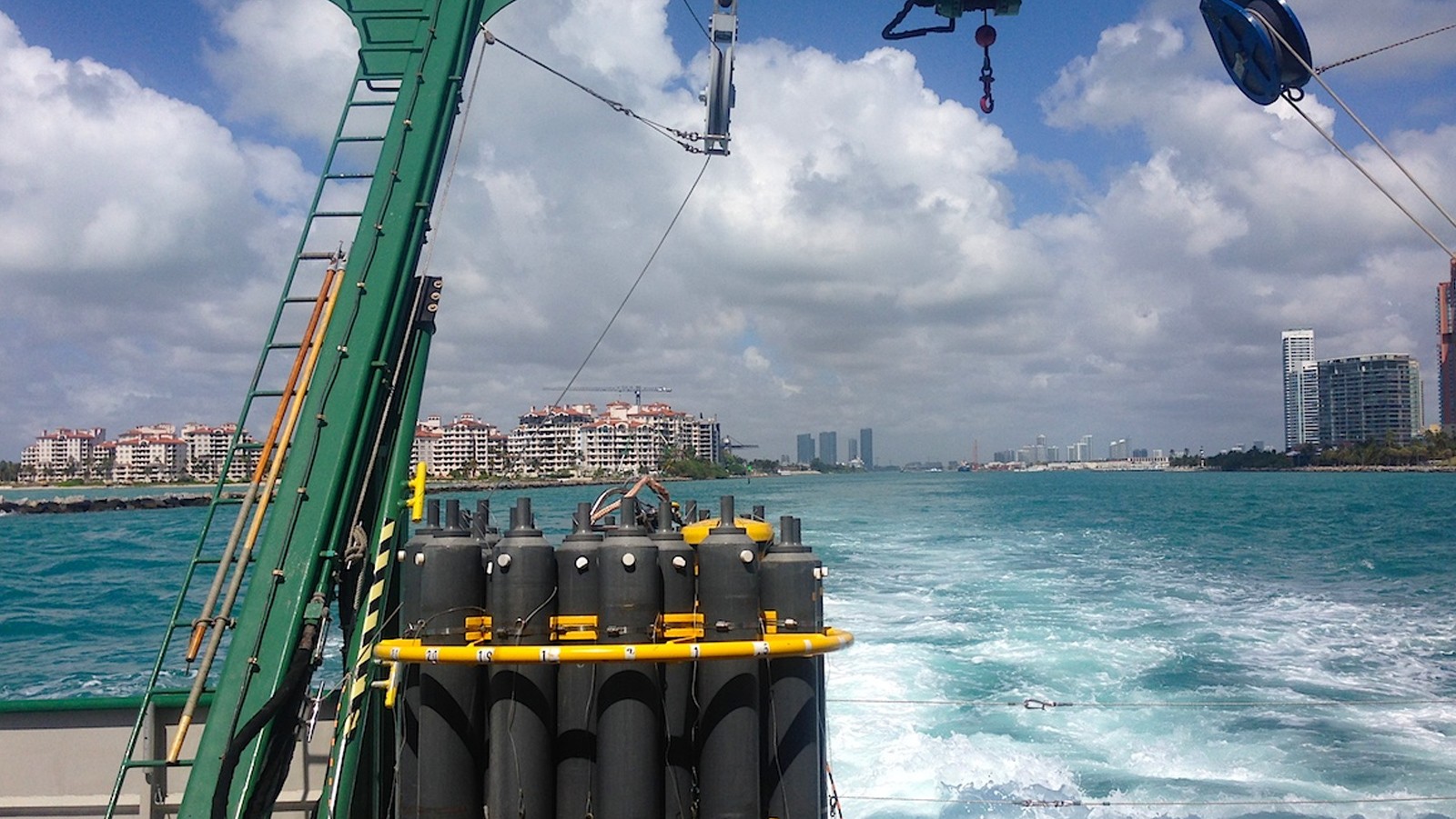
Hydrographic Cruises
Cruises are used to monitor both components of the western boundary currents in the subtropical Atlantic: the Florida Current and the Deep Western Boundary Current. Approximately every 9 months, a hydrographic cruise is carried out east of Abaco Island to measure water mass properties and transports of the Antilles and Deep Western Boundary Currents. The repeated hydrographic and tracer sampling at Abaco has established a high-resolution record of water mass properties in the Deep Western Boundary Current at 26N.
The Florida Current
Transport Time Series and Cruises
The Florida Current is a strong oceanic current flowing northward along the eastern coast of Florida carrying warm tropical waters that eventually feed the Gulf Stream. The Florida Current transports are collected two ways: measuring the voltage difference across the Straits of Florida using submerged submarine telephone cables; and via small-boat dropsonde/XBT cruises and research vessel LADCP/CTD cruises. The cable measurements provide daily transports – which have been measured nearly continuously since 1982.
The sections provide both calibration information for the transport estimates from the submarine cable and observations of changes in water properties within the Florida Current over time. Accounting for the platform-specific limitation, the Florida Current volume transport can also be inferred from cross-stream sea level differences measured by bottom pressure recorders deployed near Florida and Grand Bahama Island and by altimetry satellites that cross the Straits of Florida approximately every 10 days.

Deep Western Boundary Current
Transport Time Series
A quasi-continuous monitoring of the Deep Western Boundary Current uses six pressure inverted echo sounders (PIES) that yield hourly measurements of bottom pressure and acoustic travel time between the moored instrument and the sea surface. Data from these instruments are acoustically downloaded by a passing research vessel about every 9 months without actually recovering the instruments. The data are then brought to the lab for processing. It has been shown that combining PIES measurements with historic hydrography data can reproduce the transport of a more traditional picket-fence of current meter moorings to within the accuracy of the current meter array (Meinen et al., 2004). The image to the right shows the location of the inverted echo sounders.
Hydrography
Since 1984, the repeated hydrographic and tracer sampling at Abaco has established a high-resolution record of water mass properties in the Deep Western Boundary Current at 26N. Approximately one hydrographic cruise has been conducted east of Abaco Island every nine months. Events such as the intense convection period in the Labrador Sea and the renewal of classical Labrador Sea Water in the 1980’s are clearly reflected in the cooling and freshening of the Deep Western Boundary Current waters off Abaco, and the arrival of a strong chlorofluorocarbon pulse approximately 10 years later. This data set is unique in that it is not just a single time series site but a transport section, of which very few are available in the ocean that approach a decade in length. The image to the left shows stations frequently visited during the Deep Western Boundary Current Hydrography cruise.
Transport Time Series
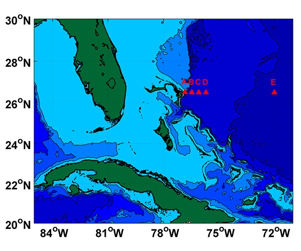
A quasi-continuous monitoring of the Deep Western Boundary Current using six pressure inverted echo sounders (PIES) that yield hourly measurements of bottom pressure and acoustic travel time between the moored instrument and the sea surface. Data from these instruments are acoustically downloaded by a passing research vessel about every 9 months without actually recovering the instruments. The data are then brought to the lab for processing. It has been shown that combining PIES measurements with historic hydrography data can reproduce the transport of a more traditional picket-fence of current meter moorings to within the accuracy of the current meter array (Meinen et al., 2004). The image to the right shows the location of the inverted echo sounders.
Hydrography
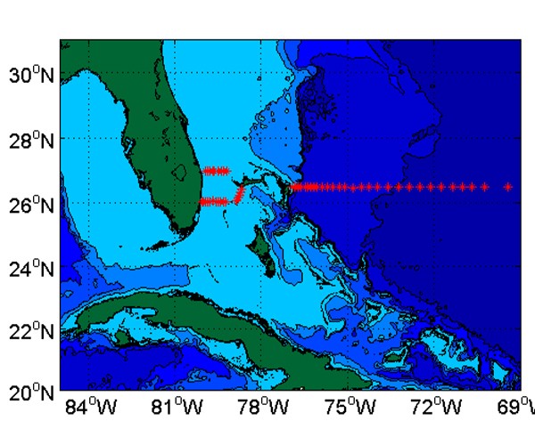
Since 1984, the repeated hydrographic and tracer sampling at Abaco has established a high-resolution record of water mass properties in the Deep Western Boundary Current at 26N. Approximately one hydrographic cruise has been conducted east of Abaco Island every nine months. Events such as the intense convection period in the Labrador Sea and the renewal of classical Labrador Sea Water in the 1980’s are clearly reflected in the cooling and freshening of the Deep Western Boundary Current waters off Abaco, and the arrival of a strong chlorofluorocarbon pulse approximately 10 years later. This data set is unique in that it is not just a single time series site but a transport section, of which very few are available in the ocean that approach a decade in length. The image to the left shows stations frequently visited during the Deep Western Boundary Current Hydrography cruise.
Building a Weather-Ready Nation.
Ocean Observing Technologies.
Scientists use different observing technologies and instruments to measure and observe the global oceans. AOML works with partners around the world to develop and maintain key components of these systems of observing technologies, known collectively as the Global Ocean Observing System.
AOML scientists design and operate new observing technologies and systems, deploy them in the ocean around the world, coordinate deployments with partners to maximize efficiency, and manage several critical aspects of data flow to insure that the data are available and of the highest quality. Visit the Global Ocean Observing System (GOOS) page to learn more.
Florida Current Transport Estimates
Transports from Vessel Surveys along 27°N in the Florida Straits (since 1982)
Daily Mean Transports from the Florida Straits Submarine Cable Voltage (since 1982)
Daily Mean Transports from the 27°N Pressure Gauges (since 2008)
Transports from Satellite Altimetry (since 1993)
All four of these products are described in greater detail on the WBTS Florida Current Transport Data Products page.
Hydrographic Survey Data
Including GPS Dropsonde, XBT, CTDO2 , and ADCP data.
Moored Time Series Data
Including Pressure Gauge and PIES moorings.
Partner Data
Meridional Overturning Circulation and Heatflux Array – MOCHA
United Kingdom’s RAPID Meridional Overturning Circulation
WBTS Bibliography
Driving Innovative Science with Data.
Our Contribution to Global Ocean Observing.
Bibliographies for Western Boundary Time Series (WBTS) peer reviewed literature and data reports are linked below. These lists are sorted by year and, in most cases, include a link to the publication. A bibliography featuring the work of scientists external to the project, but who have relied upon WBTS data to conduct their research, has also been included.
View WBTS Peer Reviewed Publications by year.
View WBTS Data Reports by year.
View Publications of Other Researchers using WBTS data by year.

Partners
Sharing Resources Delivers Results.
Expanding Reach Through Partnerships.
15
Cruises
Hydrographic and mooring cruises have been conducted with our national and international partners.
20+
Years
Years of the Atlantic MOC monitoring at 26.5N.
The Rapid Climate Change-Meridional Overturning Circulation and Heatflux Array (RAPID or MOCHA) program is a collaborative research project between the National Oceanography Centre (Southampton, U.K.), the University of Miami’s Rosenstiel School of Marine and Atmospheric Science (RSMAS), and AOML that measures the meridional overturning circulation (MOC) and ocean heat transport in the North Atlantic Ocean.
Monitoring of the Florida Current volume transport with along-track satellite altimetry, providing an alternative observing platform that is not influenced by severe weather conditions and can fill out the existing gaps in the cable data back to 1993.
2020
Bottom pressure measurements at 27N began in an attempt to establish a backup observing system for the cable measurements.
2008
The AMOC observing array at 26.5N was established, greatly facilitating climate-related studies.
2004
First Inverted Echo Sounders were deployed at 26.5N east of Abaco Island, allowing quasi-continuous estimates of the meridional transports and thermohaline structure.
2004
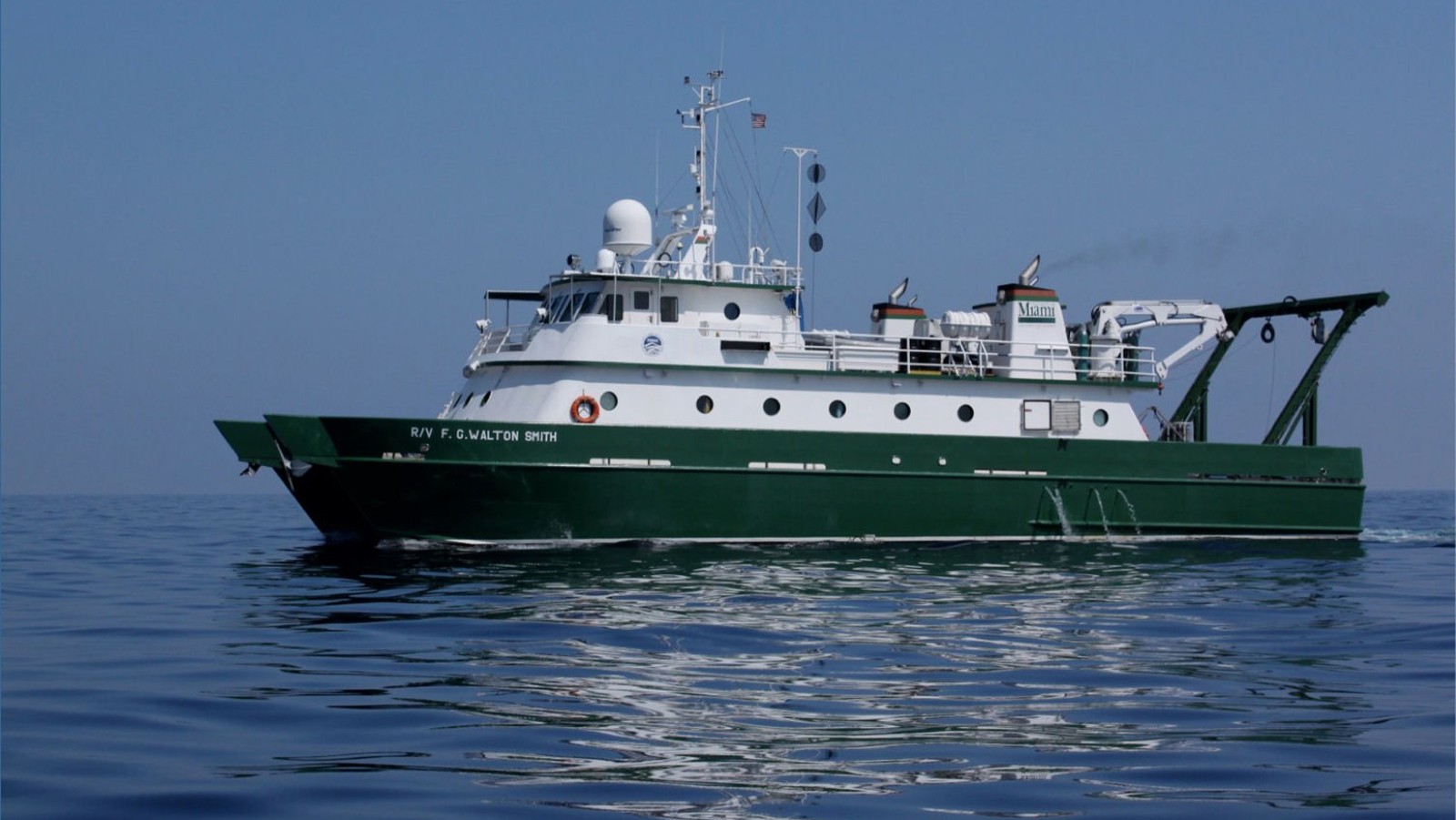
CTD/LADCP cruises at 27N on board the University of Miami RSMAS R/V “Walton Smith” started, providing direct measurements of the Florida Current for cable calibration.
2001
The start of the NOAA’s Western Boundary Time Series program.
2000
XBT measurements at 27N started.
1995
The advent of high-accuracy satellite altimetry, providing nearly global measurements of sea level anomalies.
1992
Dropsonde measurements at 27N started as a replacement for Pegasus measurements, serving for the calibration and validation of cable measurements.
1991
The Abaco time series program began when the STACS extended its Straits of Florida program to include measurements of western boundary current transports and water mass properties east of Abaco Island, Grand Bahamas.
1984
The NOAA Subtropical Atlantic Climate Studies (STACS) program began, which included quasi-continuous measurements of the Florida Current volume transport with a submarine cable.
1982