Building a Global Ocean Observing System
To Understand and Predict Changes in Weather & Climate
SCROLL TO LEARN MORE
What is the Global Ocean Observing System
The global oceans drive weather and climate systems at time scales from several days to millennia. Scientists use different observing technologies and instruments to measure and observe the global oceans. AOML works with partners around the world to develop and maintain key components of these systems of observing technologies, known collectively as the Global Ocean Observing System. The resulting observations have been shown to improve weather forecasts and advance our knowledge of climate fluctuations. AOML scientists design and operate new observing technologies and systems, deploy them in the ocean around the world, coordinate deployments with partners to maximize efficiency, and manage several critical aspects of data flow to insure that the data are available and of the highest quality.
Components of a Global Ocean Observing System:
- Argo Float Program
- Global Drifter Program
- Western Boundary Time Series Program
- NOAA Hurricane Gliders
- XBT Network and Ship of Opportunity Program
- Thermosalinograph Operations
- South Atlantic Meridional Overturning Circulation Array
- PIRATA Northeast Extension
Top News
AOML’s 2026 intern cohort gains first-hand research experience
July 30, 2026
In celebration of National Intern Day, NOAA’s Atlantic Oceanographic & Meteorological Laboratory (AOML) is proud to recognize its FY-2026 class of interns. Ranging from high school to graduate students, these talented individuals are gaining hands-on experience across a wide array of research areas—including coral reefs, microbial ecology, hurricanes, ocean acidification, physical oceanography, science communication, and […]


Read More News
Observing Methods
We Pioneer Technology to Detect Changes in the Ocean and Atmosphere.
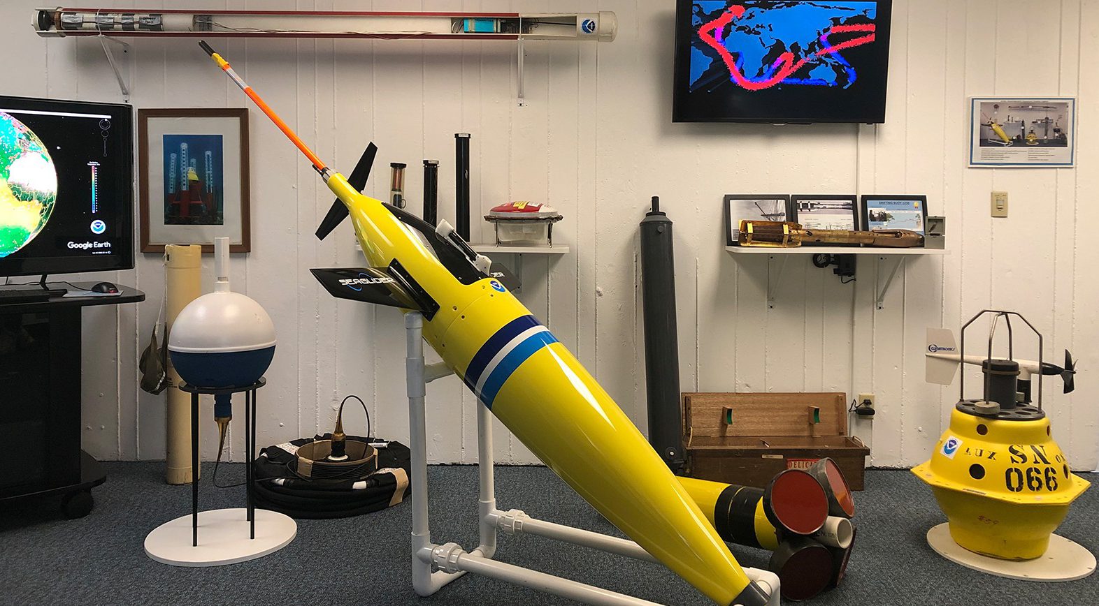
Sampling Instruments.
Our scientists use a variety of methods and variables to draw conclusions about the state and history of our global oceans. In order to measure these variables, AOML scientists have implemented several types of instruments and technologies. Hover over our photo below to learn more about each instrument.
Components of a Global Ocean Observing System
Non-Stationary Instrumentation
Hurricane Gliders, Global Drifters, and Argo Floats
AOML scientists use a variety of instrumentation to detect changes in the ocean and atmosphere. Moving platforms are ideal for collecting data around the globe. Each instrument type has a unique contribution to the Global Ocean Observing System. Drifters were the first completed component of the system, while Argo floats allow us to understand how much sea level rise is due to ocean heating and expanding. Our Hurricane Gliders have contributed data that greatly improve hurricane intensity forecasts. See details below on how AOML and its partners use non-stationary instrumentation in their research.
Long-Term Monitoring
Western Boundary Time Series, Atlantic Meridional Overturning Circulation Array, and PIRATA Northeast Extension
Our work with the Western Boundary Time Series, Atlantic Meridional Overturning Circulation Array, and PIRATA Northeast Extension has provided critical data needed to discover predictors for extreme weather events, detect changes in the ocean and atmosphere over time, and improve forecasts. AOML scientists work with partners around the globe to efficiently maintain these observing systems. The interdisciplinary uses of this data are shown in the stakeholders we provide data for: NOAA fisheries, the National Weather Service, international shipping and cargo operations, and others.
Commercial Partnerships
XBT Network, Ships of Opportunity Program, Thermosalinograph Operations
In an effort to strengthen our private sector partnerships and reduce ship time, AOML works with a growing network of commercial ships that help to collect data by deploying instrumentation while at sea. This Ship of Opportunity program capitalizes on citizen science capability by providing automatic deployment devices. The instrumentation deployed through this network has significantly contributed to the global ocean observing system.
Lightning Presentation:
The Global Ocean Observing System By Rick Lumpkin, Former Director of Physical Oceanography
Innovative Analysis of Deep and Abyssal Temperatures from Bottom-Moored Instruments
The ocean plays a major role in the distribution of heat in the climate system, however direct observations of temperature variability in the deep ocean are very sparse. A recent study (Meinen et al., 2020) led by scientists at NOAA/AOML demonstrated that an innovative use of temperature sensors located within the sphere of a pressure-equipped inverted echo sounder (PIES) mooring can provide hourly near-bottom temperature measurements over extended time periods to detect long-term abyssal temperature changes.
The results of the study led to a new NOAA-funded project entitled “Innovative analysis of deep and abyssal temperatures from bottom-moored instruments.” This project will analyze deep ocean temperature observations being collected by two existing long-term (10-15+ year) arrays of PIES moorings that have been maintained in the North and South Atlantic by NOAA, as well as examine recent and historical observations collected by international partners (e.g., Campos et al., 2021).These observations will help scientists to understand deep temperature variations and forcing mechanisms, predict future deep ocean temperature changes, and serve as a benchmark to validate ocean models. The deep temperature records will also serve as a reference data set for interpreting future deep temperature variations as new deep observational platforms are brought online, such as a global deep Argo array. These observations can be used to quantify deep ocean warming in a manner never before accomplished.
Principal Investigators: Renellys C. Perez (AOML), Shenfu Dong (AOML), Matthieu Le Hénaff (AOML), Denis Volkov (CIMAS, AOML)
Collaborators: Matthew Harrison (NOAA/GFDL), Christopher S. Meinen

Non-Stationary Instrumentation
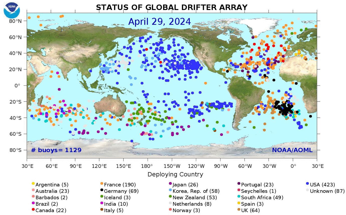
Global Drifter Program
AOML’s contribution to the Global Drifter Program consists of the Drifter Operations Center (DOC) and the Drifter Data Assembly Center (DAC). The DOC manages global drifter deployments, using volunteer ships (Ship Of Opportunity Program), research ships and aircraft. The DAC verifies that the drifters are operational, distributes the data to meteorological services via the GTS, assembles, quality controls and makes the data available on the web, and offers drifter-derived products.
The Global Drifter Program is the principle component of the Global Surface Drifting Buoy Array, a branch of NOAA’s Global Ocean Observing System and a scientific project of the Data Buoy Cooperation Panel (DBCP).
To learn more about the Global Drifter Program at AOML, visit its project page.
Improving Hurricane Forecasts With Upper Ocean Observations
The genesis, path, and intensity of Atlantic Ocean hurricanes are linked to atmospheric and ocean conditions. During the last 20 years, the improvements of hurricane intensity forecasts, and in particular of rapid intensification, have lagged behind those of hurricane track forecasts.
The goal of this work is to enhance our understanding of air-sea interaction processes during hurricane force wind events. In order to accomplish this goal, a pilot network of hurricane underwater gliders is implemented to: Assess the impact of hurricane force winds on upper ocean density structure, and Assess the impact of ocean profile data from underwater gliders in operational hurricane intensity forecasts.

Global Array of Temperature & Salinity Profiling Floats
Argo, the broad-scale global array of temperature/salinity profiling floats, is a major component of the ocean observing system. Deployment of floats began in 2000. Conceptually, Argo builds on the existing upper-ocean thermal networks, extending their spatial and temporal coverage, their depth range and accuracy, and enhancing measurements with the addition of salinity and velocity measurements. The name Argo is chosen to emphasize the strong complementary relationship of the global float array with the Jason altimeter mission.
The objective of the Argo program is to provide a quantitative description of the evolving state of the upper 2000 meters of the ocean by collecting profiles of temperature and salinity from the surface to 2000 meters. Argo data is used for initialization of ocean and coupled (ocean atmosphere) forecast models, data assimilation and dynamical model testing. It has been demonstrated that the assimilation of Argo data in the models improved weather and climate forecasts. Profiling float data have an enormous range of applications for education, operations and research.

The Prediction and Research Moored Array in the Tropical Atlantic (PIRATA)
The Prediction and Research Moored Array in the Tropical Atlantic (PIRATA) is a multinational network of ocean buoys that serves as the backbone of the integrated tropical Atlantic observing system. PIRATA allows for the collection of scientific data to improve our knowledge and understanding of ocean-atmosphere variability in the tropical Atlantic, validate satellite observations, and provide data for weather and ocean models. PIRATA is a joint project between Brazil, France, and the United States of America.
The Tropical Atlantic Current Observations Study (TACOS) is a pilot study focused on advancing understanding of ocean circulation and mixing and its impact on sea surface temperatures and the atmosphere. Using acoustic current meters augmented to the existing NOAA PIRATA Northeast Extension 4°N 23°W mooring, TACOS provides a novel time series of a horizontal velocity and its vertical shear in regions with strong ocean-atmosphere coupling on weather and climate timescales.
To learn more about the PIRATA Northeast Extension or TACOS at AOML, visit their project pages.

Western Boundary Time Series
The Western Boundary time series project monitors the Deep Western Boundary Current (DWBC) in the subtropical Atlantic Ocean. These observations monitor and assess rapid climatic change using transport and property measurements of the Florida and Western Boundary Currents. Measurements are obtained using shipboard and mooring observations.

Florida Current Transport Time Series and Cruises
Since 1982, the Florida Current transport has been measured using submerged telephone cables. Additional observations taken from research cruises have also contributed to this long-term monitoring. This multi-decade time series is unique in duration and helps us understand the impacts of climate fluctuations on ocean transport and sea level along the US east coast.

Deep Western Boundary Current Hydrography
AOML studies the Deep Western Boundary Current east of Abaco to monitor and assess rapid climate change. Measurements of water mass properties and transports are taken during two hydrographic cruises each year. An established transport section uses repeated water property samples to provide a high-resolution record. These observations provide data about direct velocity, salinity and oxygen. The data is unique because it is not only a transport section, but a nearly decade-long time series.
")
Deep Western Boundary Current Transport Time Series
This program, deployed in September 2004, monitors the flow of the Deep Western Boundary Current in near-real-time using acoustic measurement devices. Scientists have adapted technology such as inverted echo sounders, bottom pressure gauges, deep current meters to take these observations. Data from these submerged moorings is acoustically collected by passing research vessels every 6 months and taken back to the lab to be processed.
Atlantic Meridional Overturning Circulation
These projects monitor and investigate the variability of the South Atlantic Meridional Overturning Circulation in the western South Atlantic Ocean using shipboard and moored buoys. In order to monitor this, measurements of the full-water-column, full-basin-width, meridional velocity, temperature, and salinity are taken along a line of latitude in the South Atlantic. Monitoring the Meridional Overturning Circulation is important in tracking changes in the climate, such as precipitation and surface air temperatures.
- South Atlantic Meridional Overturning Circulation Initiative
- Southwest Atlantic Meridional Overturning Circulation
- South Atlantic Meridional Overturning Circulation Altimetry
- Argo Altimetry
- Atlantic Heat Transport Quarterly Reports
- Observing Methods for the Meridional Overturning Circulation and Meridional Heat Transport in the South Atlantic
- Assessing the Sensitivity of Northward Heat Transport/Atlantic Meridional Overturning Circulation to Forcing in Existing Numerical Model Simulations
- Assessment of the Meridional Overturning Circulation and Meridional Heat Transport and Their Meridional Variability in the South Atlantic Ocean
- South Atlantic Meridional Overturning Circulation: Pathways and Modes of Variability
Tropical Atlantic Observations for Climate and Weather
The Prediction and Research Moored Array in the Tropical Atlantic (PIRATA) is an observation network run by the United States of America, Brazil, and France aiming to improve our knowledge and understanding of climate variability in the tropical Atlantic using shipboard and moored buoy observations. PIRATA is motivated by the need for improved climate variability predictions and its impact on the countries surrounding the tropical Atlantic basin.
The project was started with a range of backbone moored buoys in 1997, and began extending in 2005 to regions like the Tropical North Atlantic, an extension led by the US. This region is known for its strong climate variations that affect rainfall rates and storm strikes. The Tropical Atlantic is a great place to study how oceanic processes drive global climate because of its relationship with the Intertropical Convergence Zone (ITCZ), its affect on West African Monsoons, and it’s role in overturning-related ventilation of the oxygen minimum zone.

Commercial Partnerships
XBT Network
EXpendable BathyThermographs (XBTs) are probes used to measure water column temperatures. They are deployed four times a year along established transects throughout all ocean basins from an international network of research vessels and volunteer ships from the Ship of Opportunity Program (SOOP). These probes operate within the upper 850 meters. AOML maintains 12 Atlantic Ocean transects along with governments and establishments from Argentina, Australia, Brazil, China, France, Germany, Italy, Japan, South Africa, and England. Temperature measurements are taken to monitor surface current changes, study meridional heat transport, and offer ways in which to assess variability of upper ocean heat content. These measurements are collected by way of a thin wire inside the probe that transmits temperature data to the ship for analysis. XBTs are significant because they provide some of the longest time series in existence, and collect important data for weather and climate forecast models and scientific applications.
To learn more about the XBT Network, visit its project page.

Ship of Opportunity Monitoring Program
The Ship of Opportunity Monitoring Program is an international program that supports a network of volunteer merchant ships and other vessels like cruises and ice breakers that deploy scientific instruments. Ships of Opportunity take measurements of oceanographic data, like temperature and acidity, in various regions of the global ocean. They can do this by recording the amount of plankton in a given area. The data obtained from this program is vital, especially for seasonal to interannual climate forecasts and predictions, studying meridional heat transfer, and understanding the effects of ocean acidification.
To learn more about the Ship of Opportunity Monitoring Program, read its brochure.

Thermosalinograph Operations
The Thermosalinograph (TSG) Operations is another measuring system that uses the Ship of Opportunity Program. These operations continuously gather data about sea surface temperature and sea surface salinity. Observations from these systems are taken from various areas in the global ocean. Long time series data is taken from underway ships of the NOAA fleet and Ship of Opportunity Program. Conductivity and thermistor cells are used to take measurements of the conductivity and temperature, which together provide measurements of salinity. Thermosalinograph data has contributed to global data collections for around two decades and is important in understanding long-term marine environment changes, determining ocean current boundary regions, and deepening our understanding climate to improve weather forecasts.
To learn more about Thermosalinograph Operations, visit its page.

We Drive Innovative Science.
Autonomous Data Pods.
Some ocean instruments such as the Pressure Inverted EchoSounder (PIES) sit on the seafloor, measuring how ocean properties change over time. One of the major challenges facing the oceanographic community is the difficulty in maintaining long-term ocean measurement systems in an era of reduced research vessel availability. Presently data from most subsurface moored instruments must be collected via research vessels. However, ship time is expensive and can be difficult to obtain.
To solve this problem, AOML engineers developed a data pod system that is able to periodically download the data from the PIES, transfer them to a pod, and release the pod to float to the ocean surface where the data are transmitted to shore using satellites. The first operational data pod system was deployed in March 2020 in the eastern North Atlantic, to monitor long-term changes in the ocean’s meridional overturning circulation.
Key Accomplishments
OceanObs’19 held in Honolulu, HI, with goal to improve governance of the Global Ocean Observing System by improving advocacy, funding, and alignment with best practices.
September 2019
An Argo float collects the two millionth profile of ocean heat and salinity.
December 2018
Deployment of 25,000th GDP drifter, from a sailing ship of The Ocean Race (formerly Volvo Ocean Race).
May 2018
An Argo float collects the one millionth profile of ocean heat and salinity.
November 2012
OceanObs’09 held in Venice, Italy; community vision expressed for the Global Ocean Observing System.
September 2009
Argo float array completed with the deployment of float #3000.
November 2007
Expansion of the PIRATA array into the main development region of tropical Atlantic hurricanes.
June 2006
The Global Drifter Program becomes the first completed component of the Global Ocean Observing System with the deployment of drifter #1250.
September 2005
OceanObs’99 held in St. Raphael, France; inception of the Argo float program.
October 1999
Deployment of the first 12 PIRATA moorings.
1997
Daily transport measurements of the Florida Current initiated.
1982
The first deployment of drifters in an effort that will evolve into the Global Drifter Program.
1979
Development of the first expendable bathythermograph (XBT).
Early 1960s