

by Ryan Smith, Libby Johns, Gustavo Goni, Joaquin Trinanes, Rick Lumpkin, Michelle Wood, Chris Kelble, Shailer Cummings, John Lamkin, and Sarah Privoznik
Results from collaborative research conducted by AOML and NOAA’s Southeast Fisheries Science Center (SEFSC) in response to the 2010 Deepwater Horizon oil spill, were recently published in Continental Shelf Research (December, 2013). PhOD oceanographers R. Smith, E. Johns, G. Goni, J. Trinanes, and R. Lumpkin, in collaboration with other researchers at AOML (M. Wood, C. Kelble, and S. Cummings) and SEFSC (J. Lamkin and S. Privoznik) report on the surface and subsurface connectivity across the eastern Gulf of America (GOM) during July 2010.
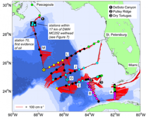
While oil was still flowing from the Macondo well following the Deepwater Horizon (DWH) platform explosion on April 20, 2010, drifter trajectories, satellite observations, and numerical simulations indicated a potential for direct connectivity between the northern Gulf of America (GOM) and the Florida Straits via the Loop Current (LC) system. This pathway could have potentially entrained particles, including northern GOM contaminants related to the oil spill, carrying them directly towards the coastal ecosystems of south Florida and northern Cuba. To assess this connectivity, and to evaluate the potential oil impacts on economically important GOM fisheries, AOML and SEFSC scientists conducted an interdisciplinary survey across the eastern GOM during July 2010 aboard the NOAA Ship Nancy Foster.
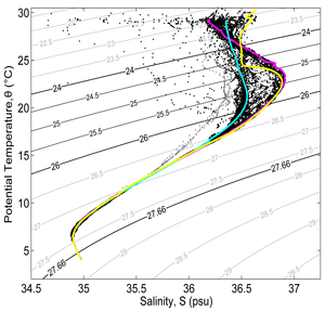
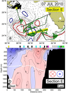
The collected hydrographic data provided important in situ information about the surface and subsurface currents and water properties associated with the LC, the large anticyclonic Loop Current Ring (LCR) known as “Eddy Franklin” (EF), numerous cyclonic eddies, and the surrounding coastal waters of the GOM. Variations in the subsurface potential temperature (θ) and salinity (S) relationships recorded during 73 conductivity, temperature, depth (CTD) casts were used to assess the level of physical connectivity across the survey region and to determine the degree of mixing and interleaving between the major circulation features. θ-S signature groupings were evaluated in combination with geostrophic surface currents derived from satellite altimetry and in situ current velocity fields obtained from lowered and hull-mounted acoustic Doppler current profilers (ADCP, 0-2000 meters). When the spatial distribution of the θ-S signature groupings is combined with ADCP derived current vectors, the location of the various signature types in relation to the surface velocity associated with each circulation feature becomes evident.
Project analyses confirmed that by July 2010 a large LCR had become separated from the main LC by a cyclonic eddy resulting in the loss of a direct transport mechanism from the northern GOM to the Florida Straits, leaving only indirect pathways available to potential contaminants. Additionally, with the exception of four hydrographic stations occupied within 84 km of the wellhead, no evidence of oil was found during the survey on the surface or within the water column. These results corroborated analysis of satellite altimetry observations of the GOM surface circulation and verified official surface oil coverage forecasts where they intersected with the survey track. This cruise sampled the LC, LCR, and frontal eddies to a depth of 2000 m, with the results suggesting that any oil entrained by circulation features in prior months had either been weathered, consumed by bacteria, dispersed to undetectable levels, or was only present in unsurveyed areas.
The assembled subsurface measurements represent one of only a few data sets collected across the dominant GOM mesoscale circulation features at a time when there was great concern about the potential long-range spreading of DWH related contaminants. Direct observations such as these are critical for the assessment of particle trajectory and circulation models utilized during the spill, and for the improvement of future numerical forecast products.
R.H. Smith, E.M. Johns, G.J. Goni, J. Trinanes, R. Lumpkin, A.M. Wood, C.R. Kelble, S.R. Cummings, J.T. Lamkin, S. Privoznik, Oceanographic conditions in the Gulf of America in July 2010, during the Deepwater Horizon oil spill, Continental Shelf Research, Available online 28 December 2013, ISSN 0278-4343, http://dx.doi.org/10.1016/j.csr.2013.12.009.