by Dilon Amaya, and Gregory Foltz
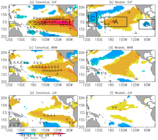
Results from research performed by Dillon Amaya, an undergraduate Hollings Scholar from Texas A&M University, were published recently in Journal of Geophysical Research. Dillon’s work was carried out in the Physical Oceanography Division of AOML during the summer of 2013 and focused on understanding the impacts of different types of El Niño events (“canonical” and “Modoki”) on sea surface temperatures in the tropical Atlantic. The main result from the research is that Modoki El Niño;s fail to produce significant warming in the tropical North Atlantic, in contrast to the well known warming following canonical events.
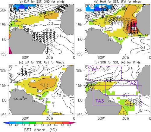
El Niño is a pattern of anomalously warm sea surface temperature (SST) in the equatorial Pacific that impacts global weather and climate through atmospheric teleconnections. Strong El Niño events have been linked to a strengthening of the Pacific/North American (PNA) pattern, namely a deepening of the Aleutian Low, above-average geopotential heights over the intermountain region of North America, and below-average heights over the southeastern United States. Anomalously low heights over the southeastern United States, forced by the PNA pattern, act to weaken the semi-permanent subtropical high over the North Atlantic, reducing evaporative cooling of the ocean’s surface and increasing SST . The anomalously warm SST in the tropical North Atlantic tends to peak in boreal spring, approximately one season after the typical peak of an El Niño event in boreal winter.
In recent years, a growing body of research has emphasized the existence of noncanonical or “nontraditional” flavors of El Niño. These noncanonical El Niño events are referred to as dateline, central Pacific, warmpool, or Modoki in the literature. Noncanonical El Niño;s, including Modoki, are characterized by the warmest SST anomalies in the central equatorial Pacific, whereas the traditional El Niño events peak in the eastern equatorial Pacific.
In this study, the impacts of canonical and Modoki El Niño on tropical Atlantic SST were quantified using composite analysis. Results show that El Niño Modoki fails to produce significant warming in the tropical Atlantic, in contrast to the well known warming following canonical El Niño events. El Niño Modoki instead induces significant cooling in the northeastern tropical Atlantic and near-neutral conditions elsewhere in the tropical Atlantic. The difference in SST response stems primarily from a much stronger PNA teleconnection pattern and stronger atmospheric Kelvin wave response during canonical events compared to Modoki. The stronger PNA pattern and Kelvin waves during canonical events generate anomalously weak surface winds in the tropical North Atlantic, driving anomalously weak evaporative cooling and warmer SSTs. Past research has shown significant decadal variability in the frequency of noncanonical El Niño;s relative to canonical events. If such variability continues, it is likely that the impact of El Niño on tropical Atlantic SST will also fluctuate from one decade to the next.