
by Renellys C. Perez, Verena Hormann, Rick Lumpkin, Peter Brandt, William. E. Johns, Fabrice Hernandez, Claudia Schmid, and Bernard Bourles
In an article recently published in Climate Dynamics (Perez et al., 2013) , scientists in PhOD (R. Perez, R. Lumpkin, C. Schmid) described for the first time the mean vertical and cross-equatorial structure of the upper-ocean meridional currents in the Atlantic cold tongue region, using in situ observations including drifters, Argo, shipboard/lowered ADCP, and moored ADCP. This study involves collaborations with scientists from the University of Miami, Scripps Institution of Oceanography, and several international institutions and makes use of data from several major tropical Atlantic field programs including NOAA’s PIRATA Northeast Extension.
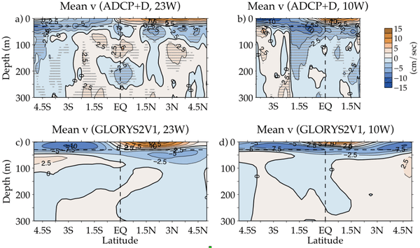
Ship-based acoustic Doppler current profiler (ADCP) velocity measurements collected in the tropical Atlantic were averaged and combined with estimates of the mean near-surface velocity derived from drifters and Argo float surface drifts (ADCP+D) to describe the mean cross-equatorial and vertical structure of the meridional currents along 23°W and 10°W. Data from moored ADCPs and fixed-depth current meters, a satellite-derived velocity product, and a global ocean reanalysis were additionally used to evaluate the mean ADCP+D meridional velocity. The dominant circulation features in the long-term mean ADCP+D meridional velocity in the upper 100 m are the tropical cells (TCs) located approximately between 5°S and 5°N, with near-surface poleward flow and subsurface equatorward flow that is stronger and shallower in the northern cell compared to the southern cell (Figure 1). From the central to the eastern Atlantic, the thickness of the TC surface limb decreases. In addition, the northern cell shifts further south of the equator from 23°W to 10°W. Seasonal means at 23°W were also estimated from the ship-based ADCP, near-surface drift, and moored velocity data, as well as the simulated fields. Details of the seasonal analysis can be found in Perez et al., (2013).
Perez, R. C., V. Hormann, R. Lumpkin, P. Brandt, W. E. Johns, F. Hernandez, C. Schmid, and B. Bourles, 2013. Mean meridional currents in the central and eastern equatorial Atlantic, Clim. Dyn., doi:10.1007/s00382-013-1968-5.