

Research cruises are essential for scientists to collect data, deploy instrumentation, and maintain ocean observing systems. NOAA regularly conducts research at sea to study the ocean and atmosphere, advancing our understanding of the ocean, monitoring ocean conditions, and ensuring sustainable fisheries and healthy marine habitats. These expeditions provide essential data for weather prediction, ocean acidification research, and fisheries management, supporting NOAA’s mission to protect marine resources and understand the interconnectedness of ocean systems.

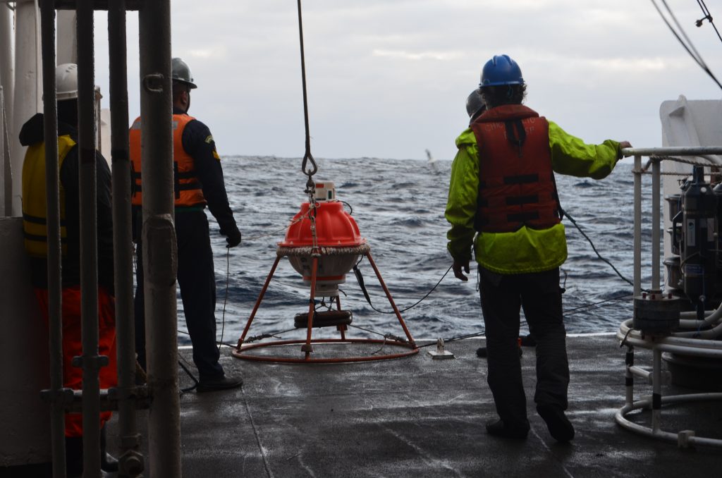
During research cruises, the ships are equipped with a CTD (Conductivity, Temperature, and Depth) to collect data. On most exploration vessels, a CTD is attached to a larger metal water sampling array known as a rosette that is lowered into the water via a cable. Multiple water sampling, or Niskin, bottles are attached to the rosette. These bottles are open when the rosette is deployed and can be triggered to close, collecting water samples at specific depths for later analysis. CTDs often include additional instruments, such as sensors to measure oxygen, water pH, nutrients, and more. All of these measurements are looked at side-by-side in relation to depth.
Here at NOAA’s Atlantic Oceanographic & Meteorological Laboratory (AOML), fieldwork is a regular part of the science being conducted at the lab. Our scientists go out on research cruises in support of various projects, some of which are highlighted below.
Western Boundary Times Series Project
As part of the Western Boundary Time Series project, cruises are used to monitor western boundary currents in the subtropical North Atlantic Ocean: the Florida Current, east of Florida in the Florida Straits, and the North Atlantic Deep Western Boundary Current east of the Bahamas. These western boundary currents are important parts of the Atlantic Meridional Overturning Circulation (AMOC) and are some of the strongest ocean currents in the world, carrying with them large amounts of heat, fresh water, nutrients, and other chemicals that alter the global and regional weather, our environment, sea level, and marine ecosystems.
Click here to read more
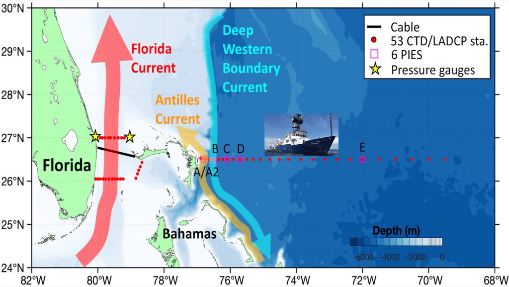
Approximately every 9 months, an 18-day hydrographic cruise is carried out east of Abaco Island to measure water mass properties and transports of the currents. The repeated sampling has established a high-resolution record of water mass properties in the Deep Western Boundary Current at a latitude of 26N.
During these expeditions, time series moorings are also serviced. The project’s pressure-equipped inverted echo sounders (PIES) or deepwater moorings provide scientists with continuous measurements of ocean conditions. These moored instruments must be recovered and replaced so that data may be recovered from them – cruises are the only way to do this. Once an old mooring is recovered, a new one, with fresh batteries, is deployed in its place to continue the time series record.
In addition to the surveys conducted every nine months, the WBTS research team leads 2-day cruises in the Florida Straits aboard the R/V F.G. Walton Smith approximately six times a year. These surveys focus on the 27°N section between West Palm Beach, Florida and the Bahamas. This fieldwork helps to quantify Florida Current volume transport and water mass changes.
PIRATA Northeast Extension
Another project that relies on ship time for its research is the PIRATA Northeast Extension project. PIRATA is a collaborative effort between Brazil, France, and the United States to study and improve predictability of ocean-atmosphere interactions in the tropical Atlantic ocean. Air-sea interactions in this region have a large impact on weather and climate variability for surrounding countries and can be a determining factor in the prediction of extreme weather and ocean changes.
Click here to read more
PIRATA Northeast Extension (PNE) is an expansion of PIRATA and is a joint project between AOML and NOAA’s Pacific Marine Environmental Laboratory (PMEL) to expand the set of tropical moored buoys into the northern and northeastern sectors of the tropical Atlantic Ocean. AOML contributes to the PIRATA program by leading cruises, collecting shipboard measurements, and deploying Argo floats and surface drifters. PIRATA buoys provide critical data that are used to develop and improve models of the Atlantic climate system, as well as used for ocean and weather prediction.

During PIRATA research cruises, scientists accomplish much more than just servicing buoys. Ship time is used wisely, and other institutions are invited on board to collect data for a variety of research projects, such as Sargassum sampling, which benefits the fields of meteorology, ocean physics, ocean ecosystems, and more.
Global Ocean Ship-Based Hydrographic Investigation (GO-SHIP)
AOML scientists also regularly participate in Global Ocean Ship-Based Hydrographic Investigation (GO-SHIP) cruises. GO-SHIP is an internationally coordinated effort to perform transects of all major ocean basins to decadally study changes in the ocean.
Click here to read more
These expeditions follow predetermined transects that monitor multiple ocean parameters. With these cruises, it is important to maintain the same cruise tracks (i.e. “transects”) and return to predetermined stations with marked coordinates where scientists can repeatedly collect samples in the same area, tracking major changes in ocean physics and chemistry over years and decades. Data gathered on GO-SHIP cruises address critical questions regarding ocean circulation and the ocean’s uptake of heat and carbon dioxide.
These GO-SHIP cruises crossing entire oceans have been performed by scientists across different countries since the 1980s, monitoring major environmental changes across decades and providing crucial insight to ocean conditions driving weather patterns.
Gulf and Ocean Monitoring Ecosystems and Carbon Cruises (GOMECC) and East Coast Ocean Acidification (ECOA)
Scientists at AOML also lead the Gulf and Ocean Monitoring Ecosystems and Carbon Cruises (GOMECC) and East Coast Ocean Acidification (ECOA) cruises every four years to assess the impacts of ocean acidification on crucial marine ecosystems across the Gulf region and greater south Atlantic.
South Florida Ecosystem Restoration Program (SFER)
In South Florida, scientists at AOML with the Ecosystem Assessment team perform seven-day South Florida Ecosystem Restoration Program (SFER) cruises from Biscayne Bay to the Florida Keys and up along the West Florida Shelf as far north as Tampa Bay collecting profiles of nutrients, salinity, temperature, chlorophyll a, dissolved inorganic carbon and total alkalinity – key parameters used to investigate the ocean carbonate system chemistry across depth.
Click here to read more
The goal of these expeditions is to investigate regional processes driving hydrographic conditions, water quality, ocean chemistry, Harmful Algal Blooms (HABs), and the associated impacts on marine habitats and marine life, from microbes to vertebrates.
Learn more here: NOAA cruises set the foundation for restoring crucial Florida ecosystems
Southwest Atlantic Meridional Overturning Circulation (SAM)
Now let’s take a deeper dive into the Southwest Atlantic Meridional Overturning Circulation (SAM) cruise that just returned from its mission earlier this month. The cruise aboard the Brazilian N. Oc. Antares departed on June 2nd from Rio de Janeiro, Brazil to collect 2.5 years of data from four AOML and four Brazilian deepwater moorings, as well as service the moorings by recovering and redeploying them with fresh batteries. These moorings are the same as used in the WBTS project, and can collect data for up to four and a half years with those batteries. CTD casts were performed at each mooring site to collect water samples for analysis. CTD measurements are used to help calibrate measurements made by the moorings.
Click here to read more

SAM seeks to observe the daily variability of key components of the AMOC in the subtropical South Atlantic Ocean, a relatively undersampled region. Variability in the AMOC, an important system of ocean currents that circulates water within the Atlantic Ocean, drives precipitation and surface temperature patterns, sea level, and extreme weather events (e.g., droughts, heat waves, hurricane intensification) across the US and the rest of the globe.
The South Atlantic Meridional Overturning Circulation (SAM) project, which began in 2009, involves an array of four pressure-equipped inverted echo sounders (PIES) along 34.5°S. Data from these instruments are used to monitor the Brazil Current and the Deep Western Boundary Current as they carry components of the AMOC, and most recently have been used to detect changes in deep and abyssal water properties (temperature, salinity, and oxygen concentration). Coupled with CTD observations collected on Argentine or Brazilian research vessels, these data are providing scientists a better understanding of the processes involved in AMOC, boundary currents, and water property changes in the South Atlantic ocean.
Leveraging the SAM array (four pressure-equipped inverted echo sounders (PIES) along 34.5°S), collaborations with Argentine, Brazilian, French, German, South African, and Spanish partners have resulted in mooring deployments across the Atlantic (South Atlantic MOC Basin-wide Array – SAMBA). These observations are used to produce continuous time series of the AMOC and assess the dynamics and variability of water properties across the South Atlantic basin.
Research cruises are an essential part of the field work we conduct in our lab to improve and advance our understanding of ocean science. By deploying and servicing ocean instruments, collecting data, and collaborating with international partners around the world, these expeditions help scientists monitor key ocean processes. The insights gained from these efforts are critical for improving weather prediction, managing marine resources, and understanding the changing state of our ocean.