
In a recent study published in AGU’s Journal of Geophysical Research – Oceans, scientists at AOML identified key ocean features that supported the rapid intensification of Hurricane Michael (2018), despite unfavorable atmospheric conditions for development. The study demonstrates the importance of using realistic ocean conditions for coupled (ocean-atmosphere) hurricane models in order to achieve the most accurate hurricane intensity forecasts.
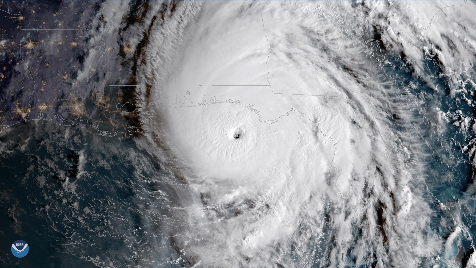
Hurricane Michael formed on October 7, 2018, in the Northwestern Caribbean Sea, and quickly travelled northward through the Gulf of America (GoM), making landfall on the Florida panhandle as a Category 5 hurricane only 3 days later. Hurricane Michael was the most intense tropical cyclone of the 2018 Atlantic hurricane season, and it was the first Category 5 hurricane to hit the continental U.S. since Hurricane Andrew in 1992. The hurricane-force winds, storm surge, and rainfall from Michael led to the death of 74 people and caused ∼$25 billion in damages in the region.
Early in its development, Hurricane Michael was exposed to vertical wind shear in the Caribbean Sea and in the southeastern GoM, which usually prevents hurricane formation or limits their intensification. Despite this unfavorable environment, Michael spent most of its trajectory prior to landfall undergoing several stages of rapid intensification, indicating that the ocean played an important role in sustaining Michael’s strength.
Using ocean observations, scientists were able to characterize the key ocean features encountered by Michael along its track, which are known for favoring hurricane intensification: high sea surface temperatures and high heat content in the Loop Current (the main current flowing through the Gulf of America) and associated eddies, and in the Mississippi River plume (seen below).
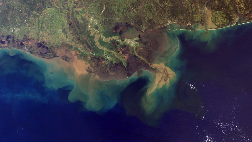
Two hurricane gliders were ideally positioned in the northeastern GoM and one of them observed the brackish waters within the Mississippi River plume. The very intense density gradient between the fresher river waters in the surface layer and the saltier ocean waters below inhibited the mixing of these two water masses. As a result, the waters in the surface layer remained warm, even under hurricane wind conditions, maintaining high sea surface temperatures and providing conditions favorable to hurricane intensification.
Numerical experiments demonstrated that the integration of satellite and in situ observations into the ocean model led to a more realistic forecast from the coupled hurricane model (see figure). In particular, it led to a 56% error reduction in the wind intensity forecast prior to Michael’s landfall.
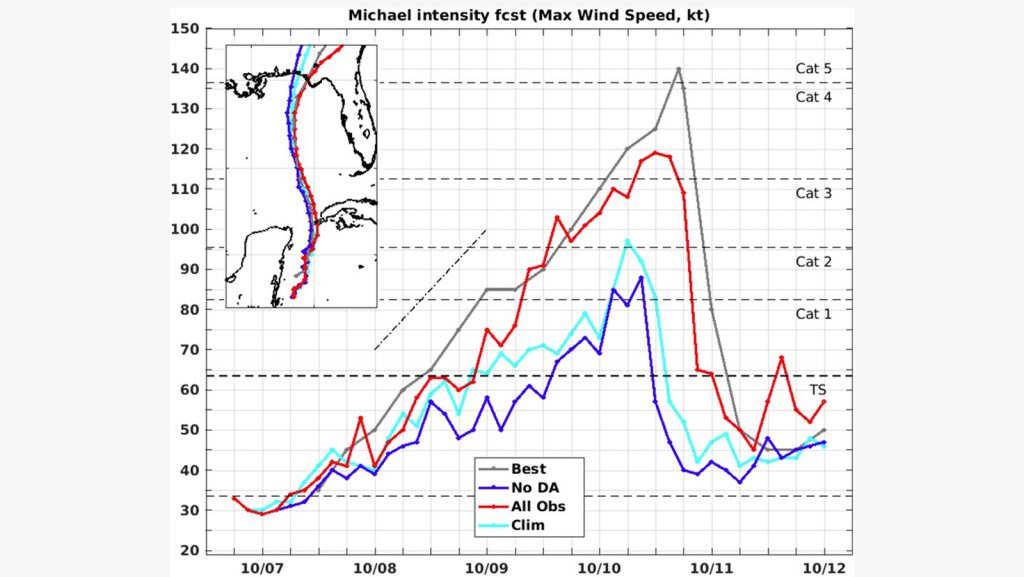
Scientists found that sea surface temperature data and vertical profiles assimilated in the ocean model were the main contributors to the intensity error reduction in the coupled model. The coupled hurricane-ocean forecasts showed that upper ocean conditions, especially the high sea surface temperatures in the northeastern Gulf, were essential to the intensification of Michael.
This study reveals how achieving realistic ocean conditions requires the combined assimilation of field and remote observations. Moreover, it shows the importance of ocean observations (Gliders, XBTs, Argo floats, and ALAMO floats) to improve real-time analyses of ocean conditions, and thus to improve operational models that provide guidance to hurricane forecasters, allowing them to better warn the public.
Reference:
Le Hénaff, M., Domingues, R., Halliwell, G., Zhang, J. A., Kim, H. S., Aristizabal, M., … & Goni, G. (2021). The role of the Gulf of America ocean conditions in the intensification of Hurricane Michael (2018). Journal of Geophysical Research: Oceans, e2020JC016969.