
Rob Rogers discusses Hurricane Sandy in Science News
http://www.sciencenews.org/view/generic/id/346130/description/How_the_Frankenstorm_came_to_life
http://www.sciencenews.org/view/generic/id/346130/description/How_the_Frankenstorm_came_to_life
Here are some pictures from the NOAA aircraft missions into Hurricane Sandy, 26-28 October 2012.

The full article can be seen at http://spectrum.ieee.org/tech-talk/telecom/internet/hurricane-sandy-water-water-everywhere

You can listen to the show at http://onpoint.wbur.org/2012/10/30/the-wrath-of-sandy
As Hurricane Sandy continued to move northward up the east coast east of the Carolinas (coast is visible as black line in left of image) a NOAA G-IV mission collected airborne Doppler radar data to use in initializing and evaluating model guidance in conjunction with a NOAA P-3 mission. A secondary objective of the mission was to […]
As Hurricane Sandy continued to move northward up the east coast east of the Carolinas NOAA P-3 missions collected airborne Doppler radar data to use in initializing and evaluating model guidance. Included here you see images of the horizontal winds within the inner core of Sandy sampled from the tail Doppler radar on the P-3 […]
As Hurricane Sandy continued to move northward up the east coast east of the Carolinas NOAA P-3 missions collected airborne Doppler radar data to use in initializing and evaluating model guidance. Included here you see images of the horizontal winds within the inner core of Sandy sampled from the tail Doppler radar on the P-3 […]
OPERATIONS Sunday, Oct. 28, 2012 NOAA42: Is tasked for a mission into Hurricane Sandy. The flight will take off around 0400 UTC from MacDill Air Force Base. NOAA42 is flying a P-3 TDR mission. Three HRD scientists will be on this flight. NOAA42: Is tasked for a mission into Hurricane Sandy. The flight will take off around 2000 UTC […]
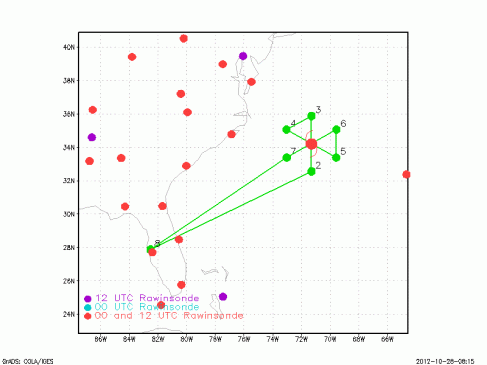
NOAA42 is now conducting its seventh and final mission into Hurricane Sandy to continue to gather Doppler radar and other data for assimilation into numerical models. The P3 will follow a butterfly pattern before returning to base for well-needed rest.
As Hurricane Sandy continued to move northward up the east coast east of the Carolinas (coast is visible as black line in upper left of image) a NOAA G-IV mission collected airborne Doppler radar data to use in initializing and evaluating model guidance in conjunction with a NOAA P-3 mission. A secondary objective of the mission was to […]