A new study from scientists at NOAA’s Atlantic Oceanographic & Meteorological Laboratory (AOML) and the University of Miami’s Cooperative Institute of Marine & Atmospheric Studies (CIMAS) investigates Hurricane Dorian’s track forecast uncertainties.
The paper, published today in Monthly Weather Review, examined a collection (ensemble) of hurricane model runs for Hurricane Dorian to learn why some models performed better than others. This analysis included two objectives: (1) determining the usefulness of ensembles for understanding how hurricanes move, and (2) correctly examining what is happening around the tropical cyclone to accurately predict its track 5 to 7 days later.
“This study shows how the newly-developed Hurricane Analysis and Forecast System (HAFS) model can be used as a research tool to understand the complexities involved with hurricane forecasting, and also shows the power of large ensembles to predict and understand the large-scale weather patterns that steer hurricanes.”
Andy Hazelton, the study’s lead author and a CIMAS Assistant Scientist at NOAA AOML.
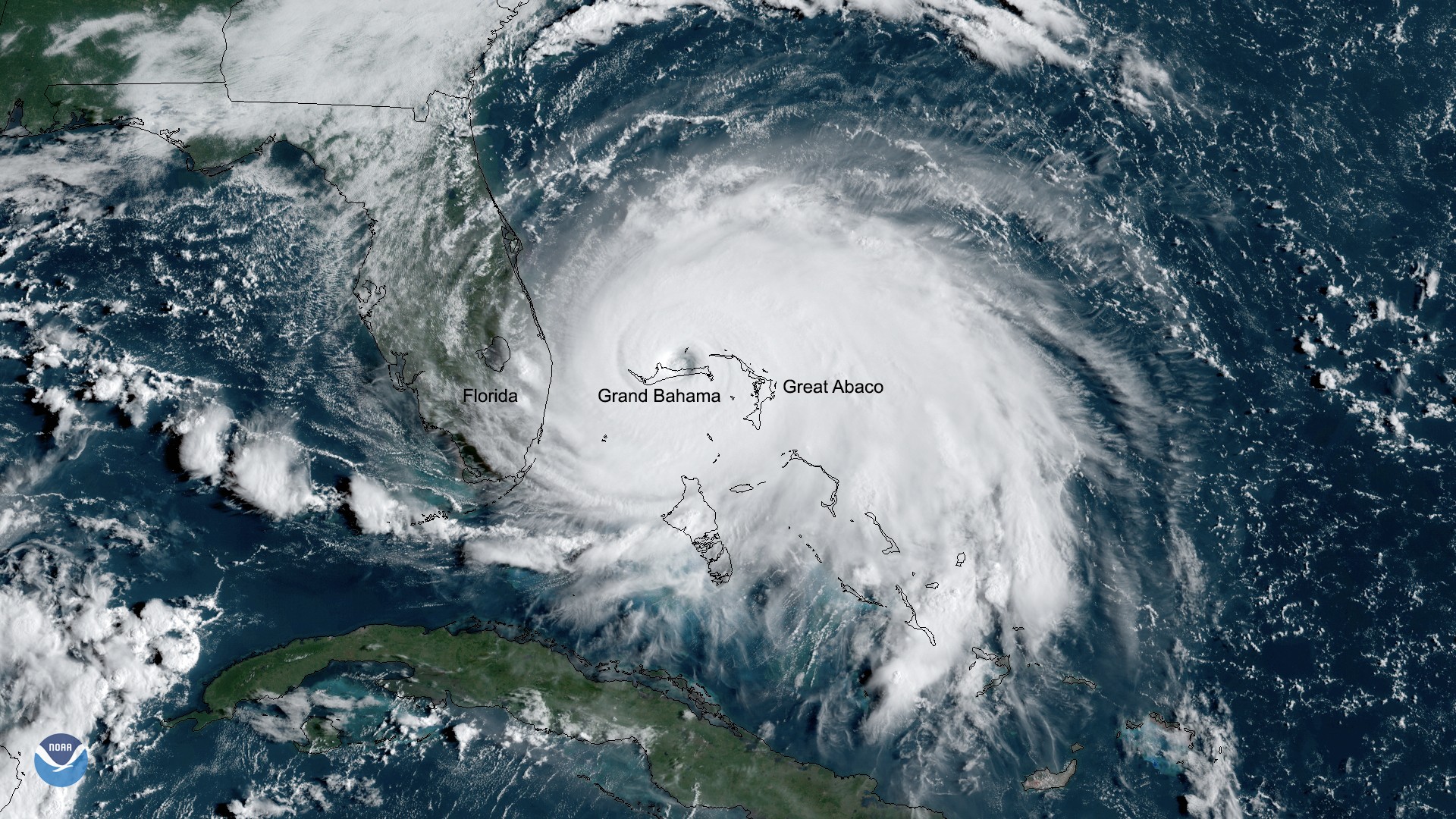
Hurricane Dorian made landfall in The Bahamas as a Category 5 hurricane in September 2019. The catastrophic storm was characterized by a large spread in track forecasts. To better understand this uncertainty, scientists studied an ensemble of 80 runs of the HAFS, which all started at the same time. Since scientists can’t measure what is happening in the atmosphere everywhere, each ensemble member started with slightly different weather, or initial conditions, that agreed with the observations they had.

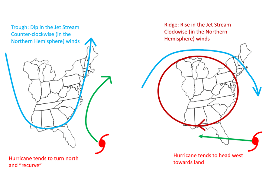
Figure 1: Tropical cyclones are “pushed” by the flow around them. This schematic shows how troughs and ridges affect their motion.
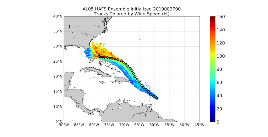
Because weather features around the storm steer hurricanes (Figure 1), scientists examined the differences between the ensemble members to determine which ones caused the track to differ. Some of the ensemble members accurately predicted Dorian’s forecast track, while others did not, as they did not accurately account for the large-scale weather features at play (Figure 2).

Figure 2: Tracks of Hurricane Dorian from all 80 HAFS ensemble members, colored by Dorian’s maximum sustained wind speed. The diamonds show the observed position and intensity.
Scientists also applied a special sensitivity analysis to determine which large-scale weather features at different time periods in the forecast were most important for the final track of Dorian. This sensitivity analysis showed that the strength of a ridge of high pressure over the western Atlantic, as well as a trough of low pressure over the eastern U.S., were critical weather features that determined Dorian’s track over The Bahamas.
Accurate hurricane track modeling over 5 and 7 day periods provides important information for researchers, decision makers, and the public. The results of this study demonstrated the effectiveness of ensemble datasets for studying tropical cyclone track forecasts, and highlighted the importance of large-scale steering features, both of which greatly improve modeling efforts. Improving modeling efforts is critical as it results in more accurate forecasts.
This analysis was led by Andy Hazelton (CIMAS), Gus Alaka (AOML), Michael Fischer (CIMAS), Sundararaman Gopalakrishnan (AOML), and Ryan Torn (SUNY-Albany). Visit the Hurricane Modeling and Prediction Program website to learn more about AOML’s efforts to develop and advance NOAA’s hurricane research and forecast modeling systems. For experimental and tropical cyclone model guidance from HAFS, HWRF, and other numerical weather prediction models, visit the AOML Hurricane Model Viewer.
Citation: Hazelton, A., G.J. Alaka Jr., M. Fischer, R. Torn, and S. Gopalakrishnan, 2022: Factors influencing the track of Hurricane Dorian (2019) in the west Atlantic: Analysis of a HAFS ensemble. Monthly Weather Review. https://doi.org/10.1175/MWR-D-22-0112.1
