Scientists at NOAA’s Atlantic Oceanographic & Meteorological Laboratory (AOML) and the University of Miami’s Cooperative Institute of Marine & Atmospheric Studies (CIMAS) examine the challenges of accurately predicting when a tropical cyclone will begin a quick and sudden increase in intensity (called rapid intensification or RI) in a new study published in Monthly Weather Review.
The paper analyzes a group (ensemble) of computer model forecasts during an actual rapid intensification event to better understand the process. In order to accurately forecast tropical cyclone intensity change and when rapid intensification may begin, it is crucial that the computer models start with the correct tropical cyclone intensity and structure so the storm’s interaction with its environment is properly predicted.

One important factor that controls how intense a tropical cyclone will get is the environmental vertical wind shear, or the difference in wind velocity between the top and bottom of the storm. High wind shear limits the ability of thunderstorms to organize around the center of the tropical cyclone and intensify the system like it can when the wind shear is low. When the wind shear is moderate, the tropical cyclone may intensify, sometimes rapidly, but may also weaken, making forecasting these systems very challenging.
“This project began as the last part of my PhD thesis back in 2018 at the University at Albany. Once I started working at AOML after graduate school, this study significantly benefited from new analyses performed in collaboration with my AOML co-authors, as we were able to perform a multifaceted examination of how vertical wind shear influences tropical cyclone intensity change.”
– Michael Fischer, the study’s lead author and a CIMAS Assistant Scientist at NOAA AOML.
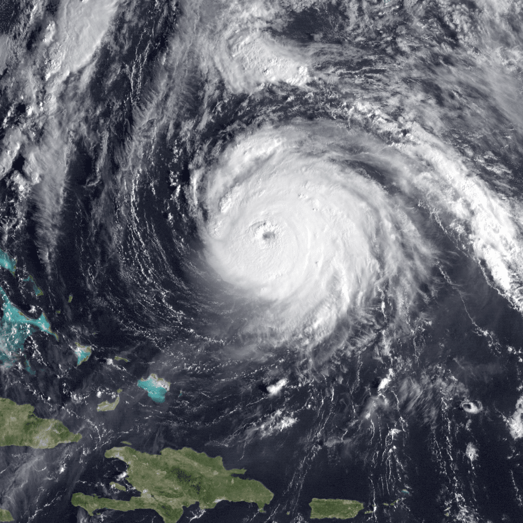
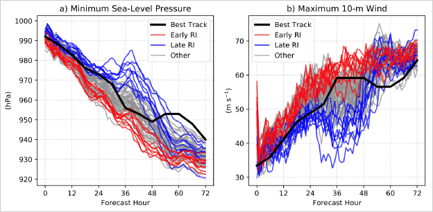
To better understand why some tropical cyclones experience rapid intensification in environments of moderate wind shear while others do not, researchers analyzed an ensemble of 60 computer model forecasts of Hurricane Gonzalo in 2014, which experienced rapid intensification [Figure 1]. Since scientists are not able to measure the precise values of temperature, pressure, moisture or wind velocity everywhere, they made small tweaks to the initial structure of Gonzalo and its environment in each ensemble member that were of the same scale as the uncertainty in the observations.

To identify why the spread in forecast intensity of Hurricane Gonzalo was so large, the study focused on two different groups of simulations. One group immediately experienced rapid intensification so Gonzalo remained very intense. This group was named the “early-RI” group (red lines in Figure 1). The second group intensified gradually at first, before experiencing a brief period of weakening due to dry air, and then finally began to undergo rapid intensification. This group was named the “late-RI” group (blue lines in Figure 1). Researchers then compared characteristics of the two groups of forecasts to learn why the differences occurred.
The key difference between early-RI and late-RI groups were traced back to differences in the initial intensity and structure of Gonzalo. At the beginning of the forecasts, storms in the early-RI group were slightly more intense and had circulating winds that were more vertically aligned than storms in the late-RI group. These differences grew with time, ultimately resulting in significantly different forecasts.
Despite recent advances, hurricane specialists struggle to accurately predict rapid intensification events. This study showed that ensemble forecasts are helpful in demonstrating the range of potential intensity outcomes for tropical cyclones. These ensemble forecasts also provided valuable insight into the processes through which environmental wind shear and dry air can interact with the tropical cyclone and modify the intensity of the storm.
This analysis was led by Michael Fischer (AOML/CIMAS), Paul Reasor (AOML), Brian H. Tang (SUNY-Albany), Kristen L. Corbosiero (SUNY-Albany), Ryan D. Torn (SUNY-Albany) and Xiaomin Chen (AOML/NGI). Visit the Hurricane Modeling and Prediction Program website to learn more about AOML’s efforts to improve the prediction of rapid intensification events.
Citation: Fischer, M.S., P.D. Reasor, B.H. Tang, K.L. Corbosiero, R.D. Torn, and X. Chen. A tale of two vortex evolutions: Using a high-resolution ensemble to assess the impacts of ventilation on a tropical cyclone rapid intensification event. Monthly Weather Review. https://doi.org/10.1175/MWR-D-22-0037.1
