

Join us as we celebrate and learn about our world ocean throughout National Ocean Month.
June 1st not only marks the start of National Ocean Month, it also is the first day of hurricane season. To kick off this year’s Ocean Month, we are looking at the major role the ocean plays in the formation of hurricanes and their evolution.
Tropical cyclones form over the tropical ocean sucking up heat and energy from the warm waters below to fuel the storm. Because of this strong interaction between the ocean and the atmosphere during a hurricane, improved representation of the ocean in hurricane forecast models has been shown to lead to more accurate hurricane intensity forecasts.
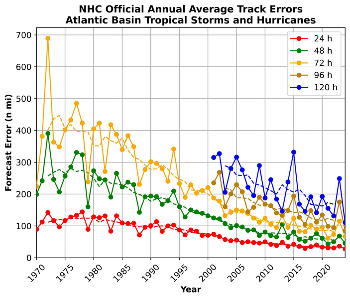
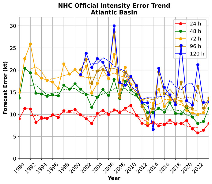
Early and accurate forecasts of storm tracks and intensity are vital for protecting life and property from hurricane impacts. During the past two decades, however, the accuracy of hurricane track predictions have generally outpaced those for storm intensity, until recently. Storm intensity is influenced by transfers of heat and momentum across the ocean surface during tropical cyclone development. Models are getting better at knowing where the storms will go, but need to continue to improve predicting how strong the storms will be.
Scientists at NOAA’s Atlantic Oceanographic and Meteorological Laboratory (AOML) work across both the physical oceanography and hurricane research divisions to combine expertise to holistically capture this crucial interaction and advance hurricane intensity forecasts.
One area that remains a challenge is the prediction of rapid intensification of tropical cyclones. Rapid intensification (RI) is the increase in the maximum sustained winds of a tropical cyclone of at least 30 kt (34 mph) in a 24 hour period. Storms that undergo RI can cause extensive damage and loss of life because of the lack of warning time for residents. Every category 5 hurricane that has ever hit the United States was a tropical storm or less 3 days prior. These quick changes in hurricane intensity are often associated with specific ocean conditions, such as high ocean temperatures, under tropical cyclones.
Real-time, in-situ observing systems are crucial for predicting these rapid changes. Sea surface temperature data has long been used as a statistical predictor of intensity, but subsurface and salinity observations are also key to better predictions. Studies have shown that the inclusion of ocean observations in models can reduce the error in wind intensity forecasts by up to 30 to 50% at landfall. Scientists at AOML play a key role in collecting observations of the ocean conditions relevant to hurricanes using a suite of ocean observing instruments.
Some observing platforms, such as drifters and Argo floats, are already in place, monitoring the ocean year-round. During hurricane season, additional systems are strategically deployed to capture key observations.
Since 2014, AOML and partners have deployed and operated underwater gliders every hurricane season to monitor ocean conditions during storms. These battery-powered ocean robots collect data down to 1000 meters (over half a mile). They are remotely operated and deployed at the beginning of hurricane season to gather information in areas where storms often form but ocean data is limited. Gliders are equipped with sensors to measure salinity, temperature, and other environmental parameters as they travel through the ocean making regular dives along set courses, surfacing several times a day, and transmitting data via satellite for immediate use in scientific analysis and hurricane forecast models.
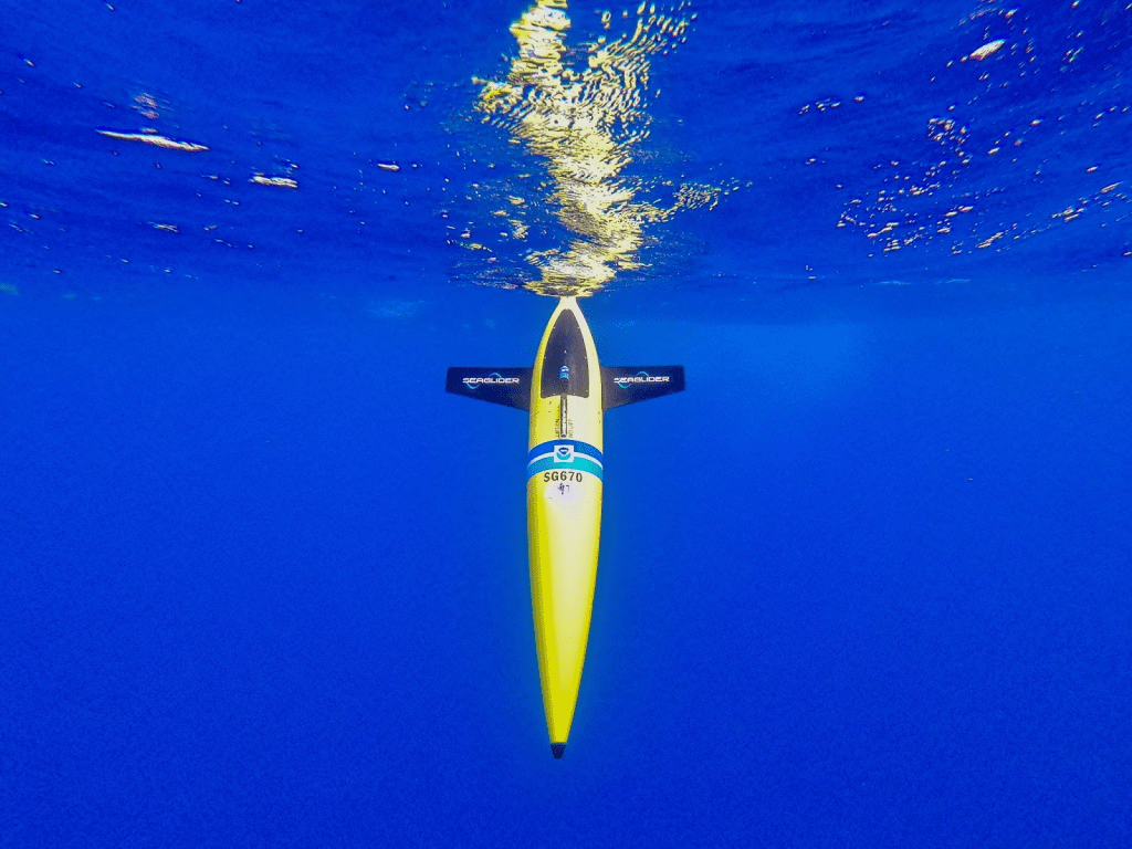
The locations surveyed by the gliders include some of the essential ocean features that can affect the intensity of a hurricane, such as eddies, warm currents, or freshwater from rivers. As a hurricane travels over the ocean, warm surface water mixes with cooler water below, which can weaken the storm. But freshwater on the surface can impede this mixing, allowing the storm to remain strong. This is why salinity data in the upper ocean is important for improving forecasts. Gliders are especially adapted to observe these freshwater layers, which satellites can’t see well, allowing this ocean feature to be better represented in hurricane forecast models. AOML’s gliders are a critical component to NOAA’s Integrated Ocean Observing System Hurricane Glider Coordination efforts.
Additionally, AOML scientists are a key leader in NOAA’s Global Ocean Monitoring and Observing Program’s Extreme Events Program. Together, they lead the Coordinated Hurricane Atmosphere-Ocean Sampling (CHAOS) Experiment: a coordinated multi-platform, multi-institutional approach utilizing a diverse suite of innovative observing platforms (i.e., autonomous, uncrewed, expendable) and conventional ones (e.g., aircraft) focused on targeted observations through the atmosphere and into the ocean as it relates to hurricane predictions and modeling. While the ocean provides the energy needed for storms to intensify, until recently, collocated measurements across the air-sea interface remained limited. AOML and partners are at the forefront of this progress. In addition to improving our understanding of the air-sea interactions, especially in extreme conditions, these collocated observations are pivotal for calibration and co-validation of various sensors and platforms, including both in-situ and remote sensing platforms.
One instrument used for targeted observations are Airborne eXpendable BathyThermographs (AXBTs). AXBTs are deployed from NOAA aircrafts before and during the passage of a hurricane. They are small probes that measure ocean temperature as a function of depth as they travel through the water column.

Improving NOAA’s hurricane intensity forecasts in the future will require closing existing gaps in oceanic and atmospheric observations. This season, NOAA will work with numerous partners to gather oceanic and atmospheric observations using a suite of platforms to monitor the conditions that play a role in hurricane intensity changes. Some of these observations improve today’s forecasts, while others capture the air-sea interaction processes needed to better understand and improve future weather and ocean models.