
Tropical Storm Fiona H*Wind surface wind analyses
H*Wind surface wind analyses for Tropical Storm Fiona are available at http://tinyurl.com/34dqvoh
H*Wind surface wind analyses for Tropical Storm Fiona are available at http://tinyurl.com/34dqvoh
OPERATIONS NOAA P-3s Wednesday September 1 NOAA-42: Completed its mission, landing at McDill AFB/Tampa at 11:00 AM EDT (1500 UTC). NOAA 43: N43 is sheduled to fly an IFEX Rapid Intensification and 3D Doppler missions in H. Earl with a 2000 UTC takeoff Wednesday, September 1, starting in Barbados, returning to McDill AFB/Tampa. Thursday, September […]
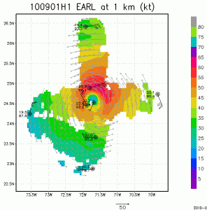
As Earl undergoes major track, but minor intensity changes as it passes just east of the Bahamas NOAA P-3 missions continue to collect airborne Doppler radar data to use in initializing and evaluating model guidance. Included here you will see images of the horizontal winds within the inner core of Hurricane Earl sampled from the […]
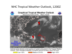
Forecast Discussion for August 30, 2010 Large-scale features The primary features of interest in the Atlantic basin are Hurricanes Danielle and Earl, and an area of disturbed weather in the central Atlantic. These features are identified on the NHC web site (Fig. 1). These features are also evident at areas of high total precipitable water. […]
OPERATIONS NOAA P-3s Tuewsday, August 31 No missions – DOWN Day Wednesday September 1 The next two P-3 flights (N42 0800 UTC Wednesday September 1) and (N43 2000 UTC Wednesday September 1) will start in Barbados, recovering at McDill AFB/Tampa. NOAA-42: N42 is scheduled for a 0800 UTC Wednesday September 1 takeoff for an IFEX […]
Mission synopsis: August 31, 2010 NOAA/IFEX NOAA has no P-3 missions planned for today. The next P-3 mission will be a take-off at 08 UTC 1 September with N42RF. The aircraft will depart Barbados, fly a mission enroute in Hurricane Earl, and recover at Macdill AFB in Tampa. N43RF will takeoff from Barbados at 20 […]
HRD scientist Michael Black and NASA scientist Gerry Heymsfield helped conduct a first ever high-altitude flyover of Tropical Storm Frank with the NASA Global Hawk unmanned aerial system (UAS). The Global Hawk flew a 13-hour mission from Edwards AFB, California to the Eastern Pacific basin to fly the low pressure system that was Hurricane Frank a couple […]

The paper can be downloaded from http://link.aip.org/link/nhrefo/v11/i3/p102/s1/html.
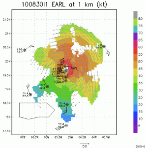
As Earl continues intensification to a major hurricane and passes just north of Puerto Rico (visible outlined in black at the bottom left of the images) NOAA P-3 missions continue to collect airborne Doppler radar data to use in initializing and evaluating model guidance. Included here you will see images of the horizontal winds within […]
OPERATIONS NOAA P-3s NOAA-42: Tuesday, August 31, 2010 is a down day. NOAA-42: Wednesday, September 1, 2010, NOAA-42 is scheduled to fly an IFEX Rapid Intensification and 3D Doppler mission in Hurricane Earl. Take-off from Barbados at 4 AM AST (0800 UTC). This mission will recover at MacDill AFB/Tampa. NOAA-43: Tuesday is a down day. […]

