NOAA42 completes first TDR mission into Arthur
Here’s the track of NOAA42 as it heads home to Tampa after completing the first in a series of Tail Doppler Radar missions into Arthur.
Here’s the track of NOAA42 as it heads home to Tampa after completing the first in a series of Tail Doppler Radar missions into Arthur.

The NOAA42 aircraft is scheduled to fly a Tail Doppler Radar Experiment into Tropical Storm Arthur at 0600 UTC (2AM Eastern) this morning. NOAA42 will take off from MacDill AFB and recover eight hours later. Below is the proposed flight pattern. The numbers on the figure represent the turn points that the aircraft will make. The red dots in the figure […]

The G-IV jet is scheduled to fly around the first storm of the 2014 Atlantic Hurricane season – Tropical Storm Arthur. The flight will take off at 1:30 PM Eastern. Below is the flight track. The dots represent the GPS dropwindsonde launch locations.
OPERATIONS Tuesday, July 1, 2014 G-IV: Is tasked by NHC to fly a synoptic surveillance mission around TS Arthur taking off at 1730 UTC (1:30PM Eastern) from MacDill and recover back at MacDill. No HRDers will be on this flight. Wednesday, July 2, 2014 NOAA42: Is tasked by EMC for a TDR mission into TS Arthur. Take off will be at 0600 […]

Aviation building with a radome on top (NWS Miami) On June 26, 1959 the first operational Weather Surveillance Radar version 1957 (WSR-57) was commissioned at Miami’s Weather Bureau office. Because of the devastating 1954 hurricane season, Congress authorized funds for the Weather Bureau to build a network of advanced weather radars, concentrating on coastal sites […]
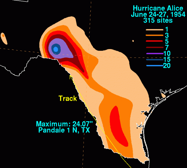
NOAA Hydrological Prediction Center’s rainfall analysis for Hurricane Alice On June 25, 1954, Hurricane Alice made landfall in northern Mexico just south of Brownsville, Texas. While the winds and storm surge were not exceptional, Alice brought heavy rains to the Pecos and Rio Grande river valleys that had been sustaining a prolonged drought. The resultant […]

Prof. Mohanty presented a seminar on “Numerical Modeling of Land Surface Processes for Improved-Simulation of Extreme Weather Events over the Indian Region” Abstract The Indian monsoon region (IMR) is recognized as one of the major ‘hot spots’ for soil moisture variations that significantly influence precipitation. During pre-monsoon season (April- May), due to land falling tropical […]
June’s Science meeting had 3 presentations: Gopal: Idealized Study of Land Surface Impacts on Tropical Cyclone Intensity Predictions Using the HWRF Modeling System Michael Maier-Gerber: Use of Spline Analysis at Mesoscale Utilizing Radar and Aircraft Instrumentation (SAMURAI) for analysis of aircraft data in Hurricane Ingrid (2013) Robert Nystrom: Use of storm-relative correlation structures in ensembles […]

On June 15, 1974, one of the largest meteorological experiments ever carried out began. The GARP* Atlantic Tropical Experiment (GATE) stretched across the tropical Atlantic, from western Africa to Barbados. This international effort used resources from 20 different countries, including 40 ocean-going vessels, a dozen research aircraft, buoys, balloons, and weather stations on land and […]

HRD is hosting four students this summer as part of various NOAA programs and collaborations with research partners. Robert Nystrom is a NOAA Hollings Scholar from the University of Illinois at Urbana-Champaign. He is working with Altug Aksoy to investigate storm-relative correlation structures in ensembles of idealized hurricane simulations. Joseph Patton is also a NOAA Hollings Scholar, and […]