Frank Marks talks about observing and predicting hurricanes with the Jamaica Observer
You can read the discussion at http://www.jamaicaobserver.com/news/Data-improves-hurricane-forecasts–but-uncertainties-remain——-_76485.
You can read the discussion at http://www.jamaicaobserver.com/news/Data-improves-hurricane-forecasts–but-uncertainties-remain——-_76485.
OPERATIONS Sunday, 9 Oct. 2016 G-IV: No flights scheduled. NOAA43: Was scheduled to fly Tail Doppler Radar missions into Matthew with take off times of 0600 UTC (2:00AM) and 1800 UTC (2:00PM). These flights are cancelled. Global Hawk: Is scheduled to land at NASA’s Armstrong Research Flight Facility, Edwards, CA around 0300 UTC (11:00PM Eastern). Monday, 10 Oct. 2016 G-IV: No […]


Read the article at http://qz.com/803994/a-lightweight-drone-is-investigating-hurricane-matthew-by-flying-into-the-eye-of-the-storm/.
OPERATIONS Saturday, 8 Oct. 2016 G-IV: No flights scheduled. NOAA43: Flew a Tail Doppler Radar mission into Matthew. They took off around 0600 UTC (2:00AM) from MacDill Air Force Base, Tampa, FL. Three HRD scientists were on this flight. NOAA43: Is scheduled fly a Tail Doppler Radar mission into Matthew. Take off is scheduled for 1800 UTC (2:00PM Eastern) to […]

The NOAA43 hurricane hunter aircraft continues to track Matthew. The P2 will conduct two flights today. The first flight takes off at 2AM Eastern (0600 UTC) from MacDill Air Force Base, Tampa, FL. Later this afternoon NOAA43 will take off at 3PM Eastern (1900 UTC). These back to back flights help us gather data in a continuous cycle. Here are […]


Read what Shirley said at http://www.dailymail.co.uk/news/article-3826697/Flying-eye-storm-Dramatic-video-shows-NOAA-pilots-enduring-turbulence-head-center-Hurricane-Matthew.html.
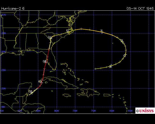
On October 8, 1946, a minimal hurricane stuck the Tampa Bay area. It was the last recorded hurricane strike in that area. The storm was first formed at the end of a cold front in the western Caribbean Sea, near British Honduras, on the evening of Oct. 5th. It moved northeastward and organized into a […]

Summary: Special radars on satellites, known as scatterometers, use the relationship between the conditions on the ocean surface and surface wind speed and direction to provide a view of the surface winds in and around tropical cyclones (hurricanes in the Atlantic and east Pacific oceans). This manuscript is an initial study of the tropical […]

Read the article at http://www.japantimes.co.jp/news/2016/10/07/world/data-improve-hurricane-forecasts-uncertainties-remain/#.V_fbaDKZMi4.


Read the article at http://www.dailymail.co.uk/sciencetech/article-3826445/Data-improves-hurricane-forecasts-uncertainties-remain.html.