Category: Physical Oceanography

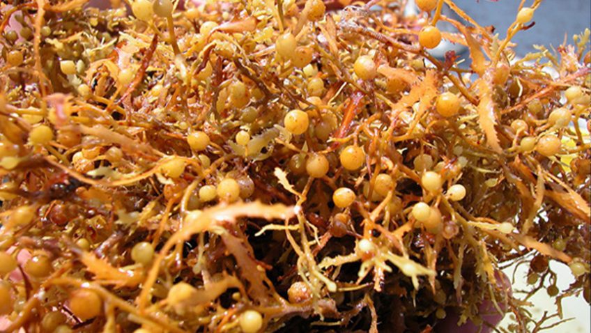
Tracking Sargassum Inundation Potential for Coastal Communities

A recently published paper presents the Sargassum Inundation Report (SIR), a product that uses a satellite-based methodology to monitor from space areas with coastal inundation of pelagic Sargassum in the tropical Atlantic Ocean, Caribbean Sea, and Gulf of Mexico. The SIR was created as a response to the need to improve the monitoring and management of Sargassum influxes (e.g., coordinate clean-up), which have major economic, social, environmental, and public health impacts.

Read Full Article

Come Sail Away: Take a Look into a Scientist’s Life Aboard a 6 Week Cruise in the Tropical Atlantic

On February 24, researchers with NOAA’s Atlantic Oceanographic and Meteorological Laboratory returned to land, docking in Key West after nearly six weeks aboard the NOAA ship Ronald H. Brown. The scientists were at sea for the PIRATA (Prediction and Research Moored Array in the Tropical Atlantic) Northeast Extension (PNE) cruise, a joint effort between AOML and NOAA’s Pacific Marine Environmental Laboratory to maintain an expansion of the PIRATA array of surface moorings into the northern and northeastern sectors of the tropical Atlantic.

Read Full Article

AOML Tests New Hurricane Ocean Profilers for Deployment in 2021 Hurricane Season

In January 2021, AOML in partnership with NOAA’s Aircraft Operations Center (AOC) completed the air launch testing of the Air-Launched Autonomous Micro-Observer (ALAMO) profiling float. This testing cleared the ALAMO floats for flight and deployed from the NOAA P3 Hurricane Hunter aircraft during their hurricane reconnaissance missions. The data collected and transmitted by the ALAMO floats will be used to understand the ocean’s interaction with tropical cyclones and improve coupled hurricane forecasting models.

Read Full Article

Scientists Discover New Current Structure in Gulf of Mexico off Cuban Coast

Scientists at AOML in collaboration with partners at the University of Miami’s Rosenstiel School of Marine and Atmospheric Science (RSMAS) have identified Loop Current related anticyclonic eddies along the northwest coast of Cuba in the southern Gulf of Mexico, named “CubAns” (“Cuba anticyclones”). These eddies play an important role in the ocean circulation associated with the Loop Current. This team of scientists is the first to study CubANs.

Read Full Article

An Experimental Outlook Model Shows a Useful Skill for Predicting Seasonal US Tornado Activity

A new paper published in Monthly Weather Review shows some promise for predicting subseasonal to seasonal tornado activity based on how key atmospheric parameters over the US respond to various climate signals, including El Niño and La Niña activity in the Pacific. In this study, a team of researchers from NOAA’s Atlantic Oceanographic and Meteorological Laboratory, Geophysical Fluid Dynamics Laboratory, and Climate Prediction Center presented an experimental seasonal tornado outlook model, named SPOTter (Seasonal Probabilistic Outlook for Tornadoes), and evaluated its prediction skill.

Read Full Article

Scientists at AOML Awarded Ocean Observing Team Award for Western Boundary Time Series Project

NOAA’s Western Boundary Time Series (WBTS) project, alongside partner projects RAPID and MOCHA, have been awarded the inaugural “Ocean Observing Team Award” by The Oceanography Society (TOS). This award recognizes innovation and excellence in sustained ocean observing for scientific and practical applications. The WBTS/RAPID/MOCHA team is recognized for significantly improving our understanding of Atlantic circulation through the breakthrough design of a basin-wide observing system using endpoint measurements to measure the variability of the overturning circulation across wide areas of the ocean. This design provided continuous, cost-effective measurements that led to a transformation in ocean observing and advances in scientific knowledge.

Read Full Article

The Global Drifter Program Launches a New Interactive Map Tool

The Global Drifter Program’s (GDP) Drifter Data Assembly Center (DAC) at AOML has launched a new interactive map of the global drifter array. This new tool features the ability to zoom and scroll, hover the cursor over drifters to get their identification numbers, and click to see data and metadata including deployment information, manufacturer, and drifter type in an ID card that can be viewed as a high-resolution image with an additional click.

Read Full Article

Hurricane Gliders Return Home from 2020 Season

NOAA’s hurricane gliders are returning home after a successful journey during the 2020 hurricane season. These gliders were deployed off the coasts of Puerto Rico, Dominican Republic, the U.S. Virgin Islands, the Gulf of Mexico, and the eastern U.S. to collect data for scientists to use to improve the accuracy of hurricane forecast models.

Read Full Article

The Argo Program: Two Decades of Ocean Observations

In a recent article published in Frontiers in Marine Science, the history of the Argo program is examined and discussed. The Argo program began in 1998 when a team of international scientists, known as the “Argo Science Team,” proposed the idea for a global array of autonomous floats to obtain temperature and salinity measurements of the upper 2,000 meters of the global ocean. The new array of floats, called Argo, would go on to be endorsed as a pilot program of the Global Ocean Observing System and be used to fill in the large data gaps in ocean observations.

Read Full Article