

The ability to predict whether and when a tropical cyclone will become vertically aligned is critical for intensity change forecasts, as storms can intensify quickly after achieving an aligned structure. A recent study from researchers at NOAA’s Atlantic Oceanographic and Meteorological Laboratory and the University of Miami’s Cooperative Institute for Marine and Atmospheric Studies shows how weak, disorganized tropical cyclones containing different center locations with height, called misalignment, can develop a vertically aligned structure. This study works to improve forecasts of when this alignment might occur by identifying key times of the day and other tropical cyclone characteristics when alignment is likely.
When the center of a tropical cyclone is in roughly the same location throughout the atmosphere, the system is said to be vertically aligned. This alignment allows thunderstorms to develop completely around the center, protecting the system from the surrounding environment and therefore can be important for future tropical cyclone intensification.
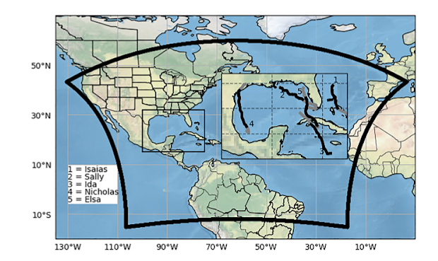
To learn how tropical cyclones become aligned, researchers used NOAA’s next-generation hurricane forecast model, the Hurricane Analysis and Forecast System (HAFS), to simulate five different tropical cyclones from the 2020 and 2021 Atlantic hurricane seasons: Elsa, Ida, Isaias, Nicholas, and Sally [Figure 1]. These model runs were compared with radar and airborne observations to identify the model cycles that most accurately portrayed the observed tilt evolution. In all but one of these simulations, the tropical cyclone achieved a successful alignment of centers, which is what happened in reality. The results of this study can be used to better understand the processes leading to alignment and intensification of tropical cyclones.
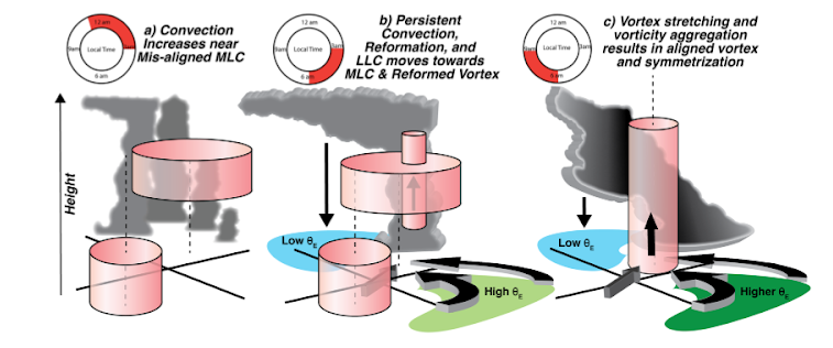
Thunderstorms prefer to develop near the mid-level center of a misaligned tropical cyclone during the early morning hours [Figure 2, Panel A], which can help to start an alignment of the centers.
If thunderstorms persist for a long enough period of time, as air rises in these thunderstorms, it is replaced by inflow, which is air flowing toward the storm center from regions surrounding the storm that have greater heat and moisture [Figure 2, Panel B]. This causes the instability, or the ability of warm, moist air to rise and create thunderstorms, to increase.
Cool air from thunderstorm downdrafts flows outward when it hits the surface, creating boundaries with the warm, unstable air that was already there. These boundaries then push the warm, unstable air upward and initiate new thunderstorms that can grow and eventually form a new tropical cyclone center. This new center develops upward with the help of the thunderstorm growth and eventually “pulls in” the old, misaligned low-level center, which results in a vertically aligned tropical cyclone.
Citation: Alvey, G. R. III, & Hazelton, A. (2022). How do weak, misaligned tropical cyclones evolve toward alignment? A multi-case study using the Hurricane Analysis and Forecast System. Journal of Geophysical Research: Atmospheres, 127, e2022JD037268. https://doi.org/10.1029/2022JD037268