Flight Logs
2021 Hurricane Field Program
Mission Summary 20210702H1
|
Tasking ID |
0205A |
Aircraft |
NOAA42 |
|
Tasked by |
EMC |
Planned pattern |
|
|
Takeoff time |
1431 Z |
Landing time |
2049 Z |
|
Takeoff Location |
Aruba |
Landing Location |
Aruba |
|
Flight Time |
6.3 hours |
Block Tine |
6.6 hours |
Expendables
| Real-time Radar Analyses: Total/Transmitted |
3/3 | Dropsondes: Total/Good/Transmitted |
16/15/15 |
|
Ocean Expendables |
0 |
sUAS |
0 |
Experiments & Modules
|
APHEX Experiments & Modules |
Data & Forms
| Flight Director Log |
Flight Director Summary |
Crew Lists
Science Crew
| Science Crew Manifest | |||
| Onboard | Ground | ||
|
Lead Scientist(s) |
None |
Lead Scientist(s) |
Dunion |
|
Radar Scientist(s) |
None |
Radar Scientist(s) |
Gamache, Reasor |
|
Sonde Scientist(s) |
None |
Sonde Scientist(s) |
Sellwood, Hazelton |
|
NESDIS Scientist(s) |
None |
||
|
Guests (Affiliation) |
None |
||
Aircraft Crew
| Aircraft Crew Manifest | |
|
Pilot(s) |
Didier, Legidakes, Rannenberg, Copare |
|
Navigator(s) |
Utama |
|
Flight Engineer(s) |
Sanchez |
|
Flight Director(s) |
Carpenter |
|
Data Technician(s) |
T. Richards |
|
AVAPS Tech(s) |
C. Lynch |
Flight Log
Pre-Flight

Mission Summary 20210703H1
|
Tasking ID |
0605A |
Aircraft |
NOAA42 |
|
Tasked by |
EMC |
Planned pattern |
|
|
Takeoff time |
1538 Z |
Landing time |
2242 Z |
|
Takeoff Location |
Aruba |
Landing Location |
Lakeland |
|
Flight Time |
7.0 hours |
Block Tine |
7.3 hours |
Expendables
| Real-time Radar Analyses: Total/Transmitted |
4/4 | Dropsondes: Total/Good/Transmitted |
18/17/17 |
|
Ocean Expendables |
0 |
sUAS |
0 |
Experiments & Modules
|
APHEX Experiments & Modules |
Data & Forms
| Flight Director Log |
Flight Director Summary |
Crew Lists
Science Crew
| Science Crew Manifest | |||
| Onboard | Ground | ||
|
Lead Scientist(s) |
None |
Lead Scientist(s) |
Zawislak |
|
Radar Scientist(s) |
None |
Radar Scientist(s) |
Gamache, Reasor, Fischer |
|
Sonde Scientist(s) |
None |
Sonde Scientist(s) |
Sellwood, Aberson |
|
NESDIS Scientist(s) |
None |
||
|
Guests (Affiliation) |
None |
||
Aircraft Crew
| Aircraft Crew Manifest | |
|
Pilot(s) |
Abitbol, Shaw, Stateler |
|
Navigator(s) |
Urato |
|
Flight Engineer(s) |
Darby, Heysteck |
|
Flight Director(s) |
Parrish, Hathaway |
|
Data Technician(s) |
Mascaro |
|
AVAPS Tech(s) |
Warnecke |
Flight Log
Mission Summary 20210704H1
|
Tasking ID |
0905A |
Aircraft |
NOAA42 |
|
Tasked by |
NHC/EMC |
Planned pattern |
|
|
Takeoff time |
0828 Z |
Landing time |
1623 Z |
|
Takeoff Location |
Lakeland |
Landing Location |
Lakeland |
|
Flight Time |
8.0 hours |
Block Tine |
8.2 hours |
Expendables
| Real-time Radar Analyses: Total/Transmitted |
3/3 | Dropsondes: Total/Good/Transmitted |
14/13/13 |
|
Ocean Expendables |
0 |
sUAS |
0 |
Experiments & Modules
|
APHEX Experiments & Modules |
Data & Forms
Crew Lists
Science Crew
| Science Crew Manifest | |||
| Onboard | Ground | ||
|
Lead Scientist(s) |
None |
Lead Scientist(s) |
Dunion |
|
Radar Scientist(s) |
None |
Radar Scientist(s) |
Gamache, Reasor |
|
Sonde Scientist(s) |
None |
Sonde Scientist(s) |
Sellwood, Aberson |
|
NESDIS Scientist(s) |
None |
||
|
Guests (Affiliation) |
None |
||
Aircraft Crew
| Aircraft Crew Manifest | |
|
Pilot(s) |
Didier, Legidakes, Rannenberg, Copare |
|
Navigator(s) |
Freeman |
|
Flight Engineer(s) |
Sanchez |
|
Flight Director(s) |
Carpenter |
|
Data Technician(s) |
T. Richards |
|
AVAPS Tech(s) |
C. Lynch |
Flight Log
Mission Summary 20210705H1
|
Tasking ID |
1105A |
Aircraft |
NOAA42 |
|
Tasked by |
NHC/EMC |
Planned pattern |
|
|
Takeoff time |
0853 Z |
Landing time |
1545 Z |
|
Takeoff Location |
Lakeland |
Landing Location |
Lakeland |
|
Flight Time |
6.9 hours |
Block Tine |
7.1 hours |
Expendables
| Real-time Radar Analyses: Total/Transmitted |
4/4 | Dropsondes: Total/Good/Transmitted |
11/11/11 |
|
Ocean Expendables |
0 |
sUAS |
0 |
Experiments & Modules
|
APHEX Experiments & Modules |
Data & Forms
Crew Lists
Science Crew
| Science Crew Manifest | |||
| Onboard | Ground | ||
|
Lead Scientist(s) |
None |
Lead Scientist(s) |
Dunion |
|
Radar Scientist(s) |
None |
Radar Scientist(s) |
Gamache, Reasor |
|
Sonde Scientist(s) |
None |
Sonde Scientist(s) |
Sellwood, Aberson |
|
NESDIS Scientist(s) |
None |
||
|
Guests (Affiliation) |
None |
||
Aircraft Crew
| Aircraft Crew Manifest | |
|
Pilot(s) |
Didier, Legidakes, Rannenberg, Copare |
|
Navigator(s) |
Freeman |
|
Flight Engineer(s) |
Sanchez |
|
Flight Director(s) |
Carpenter |
|
Data Technician(s) |
T. Richards |
|
AVAPS Tech(s) |
C. Lynch |
Flight Log
Pre-Flight
Mission Summary 20210810I1
|
Tasking ID |
0106A |
Aircraft |
NOAA43 |
|
Tasked by |
NHC |
Planned pattern |
Alpha |
|
Takeoff time |
0839 Z |
Landing time |
1645 Z |
|
Takeoff Location |
Lakeland |
Landing Location |
Aruba |
|
Flight Time |
8.3 hours |
Block Tine |
8.1 hours |
Expendables
| Real-time Radar Analyses: Total/Transmitted |
3/3 | Dropsondes: Total/Good/Transmitted |
3/3/3 |
|
Ocean Expendables |
0 |
sUAS |
0 |
Experiments & Modules
|
APHEX Experiments & Modules |
|
Data & Forms
Crew Lists
Science Crew
| Science Crew Manifest | |||
| Onboard | Ground | ||
|
Lead Scientist(s) |
Marks |
Lead Scientist(s) |
Dunion |
|
Radar Scientist(s) |
Marks |
Radar Scientist(s) |
Reasor |
|
Sonde Scientist(s) |
Wadler |
Sonde Scientist(s) |
None |
|
NESDIS Scientist(s) |
Chang, Jelenak |
||
|
Guests (Affiliation) |
None |
||
Aircraft Crew
| Aircraft Crew Manifest | |
|
Pilot(s) |
Abitol, Stateler, Shaw |
|
Navigator(s) |
Brian Richards |
|
Flight Engineer(s) |
Sanchez, Stokes |
|
Flight Director(s) |
Lundry, Hathaway |
|
Data Technician(s) |
Todd Richards |
|
AVAPS Tech(s) |
Warnecke |
Flight Log
Pre-Flight
Mission Summary 20210811I1
|
Tasking ID |
0306A |
Aircraft |
NOAA43 |
|
Tasked by |
EMC |
Planned pattern |
|
|
Takeoff time |
0837 Z |
Landing time |
1557 Z |
|
Takeoff Location |
Aruba |
Landing Location |
Lakeland |
|
Flight Time |
7.3 hours |
Block Tine |
7.5 hours |
Expendables
| Real-time Radar Analyses: Total/Transmitted |
3/0 | Dropsondes: Total/Good/Transmitted |
17/16/12 |
|
Ocean Expendables |
0 |
sUAS |
0 |
Experiments & Modules
|
APHEX Experiments & Modules |
Data & Forms
Crew Lists
Science Crew
| Science Crew Manifest | |||
| Onboard | Ground | ||
|
Lead Scientist(s) |
Marks |
Lead Scientist(s) |
Hazelton |
|
Radar Scientist(s) |
Marks |
Radar Scientist(s) |
Reasor |
|
Sonde Scientist(s) |
Wadler |
Sonde Scientist(s) |
None |
|
NESDIS Scientist(s) |
Chang, Jelenak |
||
|
Guests (Affiliation) |
None |
||
Aircraft Crew
| Aircraft Crew Manifest | |
|
Pilot(s) |
Abitol, Sateher |
|
Navigator(s) |
Shaw |
|
Flight Engineer(s) |
Sanchez |
|
Flight Director(s) |
Lundry, Hathaway |
|
Data Technician(s) |
Todd Richards |
|
AVAPS Tech(s) |
Warnecke |
|
Deadhead(s) |
Stokes, Kregelka |
Flight Log
Mission Summary 20210811H1
|
Tasking ID |
0406A |
Aircraft |
NOAA42 |
|
Tasked by |
EMC/NHC |
Planned pattern |
|
|
Takeoff time |
1946 Z |
Landing time |
0315 Z |
|
Takeoff Location |
Lakeland |
Landing Location |
Lakeland |
|
Flight Time |
7.5 hours |
Block Tine |
7.9 hours |
Expendables
| Real-time Radar Analyses: Total/Transmitted |
2/2 | Dropsondes: Total/Good/Transmitted |
22/20/20 |
|
Ocean Expendables |
0 |
sUAS |
0 |
Experiments & Modules
|
APHEX Experiments & Modules |
Data & Forms
Crew Lists
Science Crew
| Science Crew Manifest | |||
| Onboard | Ground | ||
|
Lead Scientist(s) |
Zawislak |
Lead Scientist(s) |
Rogers |
|
Radar Scientist(s) |
Sellwood |
Radar Scientist(s) |
Gamache, Alvey |
|
Sonde Scientist(s) |
None |
Sonde Scientist(s) |
None |
|
NESDIS Scientist(s) |
None |
||
|
Guests (Affiliation) |
None |
||
Aircraft Crew
| Aircraft Crew Manifest | |
|
Pilot(s) |
Mitchell, Rannenberg, Copare |
|
Navigator(s) |
Urato |
|
Flight Engineer(s) |
Darby, Wysinger |
|
Flight Director(s) |
Carpenter |
|
Data Technician(s) |
Underwood |
|
AVAPS Tech(s) |
|
Flight Log
Mission Summary 20210812H1
|
Tasking ID |
0506A |
Aircraft |
NOAA42 |
|
Tasked by |
EMC/NHC |
Planned pattern |
|
|
Takeoff time |
0805 Z |
Landing time |
1448 Z |
|
Takeoff Location |
Lakeland |
Landing Location |
Lakeland |
|
Flight Time |
6.7 hours |
Block Tine |
7.0 hours |
Expendables
| Real-time Radar Analyses: Total/Transmitted |
3/3 | Dropsondes: Total/Good/Transmitted |
14/14/14 |
|
Ocean Expendables |
0 |
sUAS |
0 |
Experiments & Modules
|
APHEX Experiments & Modules |
Data & Forms
Crew Lists
Science Crew
| Science Crew Manifest | |||
| Onboard | Ground | ||
|
Lead Scientist(s) |
Marks |
Lead Scientist(s) |
Bucci |
|
Radar Scientist(s) |
Wadler |
Radar Scientist(s) |
Fischer, Reasor |
|
Sonde Scientist(s) |
None |
Sonde Scientist(s) |
None |
|
NESDIS Scientist(s) |
None |
||
|
Guests (Affiliation) |
None |
||
Aircraft Crew
| Aircraft Crew Manifest | |
|
Pilot(s) |
Abitol, Stateler, Shaw |
|
Navigator(s) |
Brian Richard, Utama |
|
Flight Engineer(s) |
Sanchez, Stokes |
|
Flight Director(s) |
Lundry, Hataway |
|
Data Technician(s) |
Todd Richards |
|
AVAPS Tech(s) |
Warnecke |
Flight Log
Mission Summary 20210812H2
|
Tasking ID |
0706A |
Aircraft |
NOAA42 |
|
Tasked by |
EMC/NWS |
Planned pattern |
|
|
Takeoff time |
2004 Z |
Landing time |
0119 Z |
|
Takeoff Location |
Lakeland |
Landing Location |
Lakeland |
|
Flight Time |
5.3 hours |
Block Tine |
5.6 hours |
Expendables
| Real-time Radar Analyses: Total/Transmitted |
2/2 | Dropsondes: Total/Good/Transmitted |
11/10/10 |
|
Ocean Expendables |
0 |
sUAS |
0 |
Experiments & Modules
|
APHEX Experiments & Modules |
Data & Forms
Crew Lists
Science Crew
| Science Crew Manifest | |||
| Onboard | Ground | ||
|
Lead Scientist(s) |
Zawislak |
Lead Scientist(s) |
Rogers |
|
Radar Scientist(s) |
Sellwood |
Radar Scientist(s) |
Gamache, Alvey |
|
Sonde Scientist(s) |
None |
Sonde Scientist(s) |
None |
|
NESDIS Scientist(s) |
None |
||
|
Guests (Affiliation) |
None |
||
Aircraft Crew
| Aircraft Crew Manifest | |
|
Pilot(s) |
Mitchell, Rannenberg, Copare |
|
Navigator(s) |
Urato |
|
Flight Engineer(s) |
Darby, Wysinger |
|
Flight Director(s) |
Carpenter |
|
Data Technician(s) |
Mascaro |
|
AVAPS Tech(s) |
Underwood |
Flight Log
Mission Summary 20210813H1
|
Tasking ID |
0906A |
Aircraft |
NOAA42 |
|
Tasked by |
EMC/NHC |
Planned pattern |
|
|
Takeoff time |
0807 Z |
Landing time |
1248 Z |
|
Takeoff Location |
Lakeland |
Landing Location |
Lakeland |
|
Flight Time |
4.7 hours |
Block Tine |
4.9 hours |
Expendables
| Real-time Radar Analyses: Total/Transmitted |
3/3 | Dropsondes: Total/Good/Transmitted |
11/11/11 |
|
Ocean Expendables |
0 |
sUAS |
0 |
Experiments & Modules
|
APHEX Experiments & Modules |
Data & Forms
Crew Lists
Science Crew
| Science Crew Manifest | |||
| Onboard | Ground | ||
|
Lead Scientist(s) |
Aberson |
Lead Scientist(s) |
Dunion, Holbach |
|
Radar Scientist(s) |
Aberson |
Radar Scientist(s) |
Reasor |
|
Sonde Scientist(s) |
Xuejin Zhang |
Sonde Scientist(s) |
None |
|
NESDIS Scientist(s) |
None |
||
|
Guests (Affiliation) |
None |
||
Aircraft Crew
| Aircraft Crew Manifest | |
|
Pilot(s) |
Abitol, Stateler, Shaw |
|
Navigator(s) |
Brian Richard, Utama |
|
Flight Engineer(s) |
Sanchez, Stokes |
|
Flight Director(s) |
Lundry, Hataway |
|
Data Technician(s) |
Todd Richards |
|
AVAPS Tech(s) |
Warnecke, Greene |
Flight Log
Mission Summary 20210814I1
|
Tasking ID |
0107A |
Aircraft |
NOAA43 |
|
Tasked by |
NHC |
Planned pattern |
Alpha |
|
Takeoff time |
1442 Z |
Landing time |
2108 Z |
|
Takeoff Location |
Aruba |
Landing Location |
Aruba |
|
Flight Time |
6.5 hours |
Block Tine |
6.7 hours |
Expendables
| Real-time Radar Analyses: Total/Transmitted |
2/2 | Dropsondes: Total/Good/Transmitted |
7/7/7 |
|
Ocean Expendables |
0 |
sUAS |
0 |
Experiments & Modules
|
APHEX Experiments & Modules |
|
Data & Forms
Crew Lists
Science Crew
| Science Crew Manifest | |||
| Onboard | Ground | ||
|
Lead Scientist(s) |
Zawislak |
Lead Scientist(s) |
None |
|
Radar Scientist(s) |
Zawislak |
Radar Scientist(s) |
Reasor |
|
Sonde Scientist(s) |
Sellwood |
Sonde Scientist(s) |
None |
|
NESDIS Scientist(s) |
None |
||
|
Guests (Affiliation) |
None |
||
Aircraft Crew
| Aircraft Crew Manifest | |
|
Pilot(s) |
Mitchell, Ranneneberg, Copare, Legidakes |
|
Navigator(s) |
Freeman |
|
Flight Engineer(s) |
Darby, Wysinger |
|
Flight Director(s) |
Carpenter |
|
Data Technician(s) |
Mascaro |
|
AVAPS Tech(s) |
Underwood |
Flight Log
Mission Summary 20210814N1
|
Tasking ID |
WA07A |
Aircraft |
NOAA49 |
|
Tasked by |
HRD |
Planned pattern |
|
|
Takeoff time |
1634 Z |
Landing time |
0018 Z |
|
Takeoff Location |
Aruba |
Landing Location |
Aruba |
|
Flight Time |
7.7 hours |
Block Tine |
7.9 hours |
Expendables
| Real-time Radar Analyses: Total/Transmitted |
2/2 | Dropsondes: Total/Good/Transmitted |
36/33/33 |
|
Ocean Expendables |
0 |
sUAS |
0 |
Experiments & Modules
|
APHEX Experiments & Modules |
Data & Forms
Crew Lists
Science Crew
| Science Crew Manifest | |||
| Onboard | Ground | ||
|
Lead Scientist(s) |
None |
Lead Scientist(s) |
Alaka |
|
Radar Scientist(s) |
None |
Radar Scientist(s) |
Reasor |
|
Sonde Scientist(s) |
Hwnning |
Sonde Scientist(s) |
None |
|
NESDIS Scientist(s) |
None |
||
|
Guests (Affiliation) |
None |
||
Aircraft Crew
| Aircraft Crew Manifest | |
|
Pilot(s) |
Waddington, De Triquet |
|
Navigator(s) |
|
|
Flight Engineer(s) |
|
|
Flight Director(s) |
Kalen, Henning |
|
Data Technician(s) |
Miller |
|
AVAPS Tech(s) |
Patel |
Flight Log
Mission Summary 20210815I1
|
Tasking ID |
0207A |
Aircraft |
NOAA43 |
|
Tasked by |
NHC |
Planned pattern |
Alpha |
|
Takeoff time |
1553 Z |
Landing time |
2031 Z |
|
Takeoff Location |
Aruba |
Landing Location |
Aruba |
|
Flight Time |
4.6 hours |
Block Tine |
4.9 hours |
Expendables
| Real-time Radar Analyses: Total/Transmitted |
3/3 | Dropsondes: Total/Good/Transmitted |
4/4/4 |
|
Ocean Expendables |
0 |
sUAS |
0 |
Experiments & Modules
|
APHEX Experiments & Modules |
|
Data & Forms
Crew Lists
Science Crew
| Science Crew Manifest | |||
| Onboard | Ground | ||
|
Lead Scientist(s) |
Zawislak |
Lead Scientist(s) |
None |
|
Radar Scientist(s) |
Zawislak |
Radar Scientist(s) |
Reasor |
|
Sonde Scientist(s) |
Sellwood |
Sonde Scientist(s) |
None |
|
NESDIS Scientist(s) |
None |
||
|
Guests (Affiliation) |
None |
||
Aircraft Crew
| Aircraft Crew Manifest | |
|
Pilot(s) |
Mitchell, Ranneneberg, Copare, Legidakes |
|
Navigator(s) |
Freeman |
|
Flight Engineer(s) |
Darby, Wysinger |
|
Flight Director(s) |
Carpenter |
|
Data Technician(s) |
Mascaro |
|
AVAPS Tech(s) |
Underwood |
Flight Log
Mission Summary 20210815N1
|
Tasking ID |
WB07A |
Aircraft |
NOAA49 |
|
Tasked by |
HRD |
Planned pattern |
|
|
Takeoff time |
1505 Z |
Landing time |
2121 Z |
|
Takeoff Location |
Aruba |
Landing Location |
Aruba |
|
Flight Time |
6.3 hours |
Block Tine |
6.5 hours |
Expendables
| Real-time Radar Analyses: Total/Transmitted |
5/5 | Dropsondes: Total/Good/Transmitted |
32/27/27 |
|
Ocean Expendables |
0 |
sUAS |
0 |
Experiments & Modules
|
APHEX Experiments & Modules |
Data & Forms
Crew Lists
Science Crew
| Science Crew Manifest | |||
| Onboard | Ground | ||
|
Lead Scientist(s) |
None |
Lead Scientist(s) |
Hazelton |
|
Radar Scientist(s) |
None |
Radar Scientist(s) |
Gamache |
|
Sonde Scientist(s) |
Hwnning |
Sonde Scientist(s) |
None |
|
NESDIS Scientist(s) |
None |
||
|
Guests (Affiliation) |
None |
||
Aircraft Crew
| Aircraft Crew Manifest | |
|
Pilot(s) |
Waddington, De Triquet |
|
Navigator(s) |
|
|
Flight Engineer(s) |
|
|
Flight Director(s) |
Kalen, Henning |
|
Data Technician(s) |
Miller |
|
AVAPS Tech(s) |
Patel |
Flight Log
Mission Summary 20210816H1
|
Tasking ID |
0507A |
Aircraft |
NOAA42 |
|
Tasked by |
EMC |
Planned pattern |
|
|
Takeoff time |
0753 Z |
Landing time |
1527 Z |
|
Takeoff Location |
Lakeland |
Landing Location |
Lakeland |
|
Flight Time |
7.6 hours |
Block Tine |
7.8 hours |
Expendables
| Real-time Radar Analyses: Total/Transmitted |
2/2 | Dropsondes: Total/Good/Transmitted |
14/12/12 |
|
Ocean Expendables |
0 |
sUAS |
0 |
Experiments & Modules
|
APHEX Experiments & Modules |
|
Data & Forms
Crew Lists
Science Crew
| Science Crew Manifest | |||
| Onboard | Ground | ||
|
Lead Scientist(s) |
Aberson |
Lead Scientist(s) |
Holbach |
|
Radar Scientist(s) |
Aberson |
Radar Scientist(s) |
Fischer, Reasor |
|
Sonde Scientist(s) |
Aberson |
Sonde Scientist(s) |
None |
|
NESDIS Scientist(s) |
None |
||
|
Guests (Affiliation) |
None |
||
Aircraft Crew
| Aircraft Crew Manifest | |
|
Pilot(s) |
Abitbol, Shaw, Stateler |
|
Navigator(s) |
Utama, Brian Richards |
|
Flight Engineer(s) |
Sanchez, Stokes |
|
Flight Director(s) |
Hathaway, Lundry |
|
Data Technician(s) |
Todd Richards |
|
AVAPS Tech(s) |
Warnecke |
Flight Log
Mission Summary 20210817H1
|
Tasking ID |
0807A |
Aircraft |
NOAA42 |
|
Tasked by |
EMC |
Planned pattern |
|
|
Takeoff time |
0757 Z |
Landing time |
1514 Z |
|
Takeoff Location |
Lakeland |
Landing Location |
Lakeland |
|
Flight Time |
7.3 hours |
Block Tine |
7.6 hours |
Expendables
| Real-time Radar Analyses: Total/Transmitted |
2/3 | Dropsondes: Total/Good/Transmitted |
14/14/14 |
|
Ocean Expendables |
0 |
sUAS |
0 |
Experiments & Modules
|
APHEX Experiments & Modules |
|
Data & Forms
Crew Lists
Science Crew
| Science Crew Manifest | |||
| Onboard | Ground | ||
|
Lead Scientist(s) |
Aberson |
Lead Scientist(s) |
Wadler |
|
Radar Scientist(s) |
Aberson |
Radar Scientist(s) |
Fischer, Reasor |
|
Sonde Scientist(s) |
None |
Sonde Scientist(s) |
Dunion |
|
NESDIS Scientist(s) |
None |
||
|
Guests (Affiliation) |
None |
||
Aircraft Crew
| Aircraft Crew Manifest | |
|
Pilot(s) |
Abitbol, Shaw, Stateler |
|
Navigator(s) |
Utama, Brian Richards |
|
Flight Engineer(s) |
Sanchez, Stokes. Greene |
|
Flight Director(s) |
Lundry |
|
Data Technician(s) |
Todd Richards |
|
AVAPS Tech(s) |
Warnecke |
Flight Log
Mission Summary 20210817I1
|
Tasking ID |
1007A |
Aircraft |
NOAA43 |
|
Tasked by |
EMC |
Planned pattern |
|
|
Takeoff time |
1953 Z |
Landing time |
0337 Z |
|
Takeoff Location |
Aruba |
Landing Location |
Lakeland |
|
Flight Time |
7.7 hours |
Block Tine |
8.3 hours |
Expendables
| Real-time Radar Analyses: Total/Transmitted |
4/4 | Dropsondes: Total/Good/Transmitted |
30/24/24 |
|
Ocean Expendables |
3 AXBTs |
sUAS |
0 |
Experiments & Modules
|
APHEX Experiments & Modules |
|
Data & Forms
Crew Lists
Science Crew
| Science Crew Manifest | |||
| Onboard | Ground | ||
|
Lead Scientist(s) |
Zawislak |
Lead Scientist(s) |
Alaka |
|
Radar Scientist(s) |
Zawislak |
Radar Scientist(s) |
Alvey, Gamache |
|
Sonde Scientist(s) |
Sellwood |
Sonde Scientist(s) |
None |
|
NESDIS Scientist(s) |
None |
||
|
Guests (Affiliation) |
None |
||
Aircraft Crew
| Aircraft Crew Manifest | |
|
Pilot(s) |
Mitchell, Ranneneberg, Copare, Legidakes |
|
Navigator(s) |
Freeman, Urato |
|
Flight Engineer(s) |
Darby, Wysinger |
|
Flight Director(s) |
Carpenter |
|
Data Technician(s) |
Mascaro |
|
AVAPS Tech(s) |
Underwood |
Flight Log
Mission Summary 20210818I1
|
Tasking ID |
1207A |
Aircraft |
NOAA43 |
|
Tasked by |
EMC |
Planned pattern |
|
|
Takeoff time |
0813 Z |
Landing time |
1526 Z |
|
Takeoff Location |
Lakeland |
Landing Location |
Lakeland |
|
Flight Time |
7.2 hours |
Block Tine |
7.5 hours |
Expendables
| Real-time Radar Analyses: Total/Transmitted |
3/2.5 | Dropsondes: Total/Good/Transmitted |
17/16/13 |
|
Ocean Expendables |
2 ALAMOs |
sUAS |
0 |
Experiments & Modules
|
APHEX Experiments & Modules |
Data & Forms
Crew Lists
Science Crew
| Science Crew Manifest | |||
| Onboard | Ground | ||
|
Lead Scientist(s) |
Aberson |
Lead Scientist(s) |
Bucci |
|
Radar Scientist(s) |
Aberson |
Radar Scientist(s) |
Fischer, Reasor |
|
Sonde Scientist(s) |
None |
Sonde Scientist(s) |
Dunion, Jun Zhang |
|
NESDIS Scientist(s) |
None |
||
|
Guests (Affiliation) |
None |
||
Aircraft Crew
| Aircraft Crew Manifest | |
|
Pilot(s) |
Abitbol, Stateler, Shaw |
|
Navigator(s) |
Utama |
|
Flight Engineer(s) |
Sanchez, Stokes, Greene |
|
Flight Director(s) |
Lundry |
|
Data Technician(s) |
Todd Richards |
|
AVAPS Tech(s) |
Warnecke |
Flight Log
Mission Summary 20210818H1
|
Tasking ID |
1407A |
Aircraft |
NOAA42 |
|
Tasked by |
EMC |
Planned pattern |
|
|
Takeoff time |
1954 Z |
Landing time |
0217 Z |
|
Takeoff Location |
Lakeland |
Landing Location |
Lakeland |
|
Flight Time |
6.4 hours |
Block Tine |
6.7 hours |
Expendables
| Real-time Radar Analyses: Total/Transmitted |
3/3 | Dropsondes: Total/Good/Transmitted |
26/25/25 |
|
Ocean Expendables |
5 NRL AXBTs/3 Good |
sUAS |
0 |
Experiments & Modules
|
APHEX Experiments & Modules |
|
Data & Forms
Crew Lists
Science Crew
| Science Crew Manifest | |||
| Onboard | Ground | ||
|
Lead Scientist(s) |
Zawislak |
Lead Scientist(s) |
Hazelton |
|
Radar Scientist(s) |
Zawislak |
Radar Scientist(s) |
Alvey, Gamache |
|
Sonde Scientist(s) |
Sellwood |
Sonde Scientist(s) |
None |
|
NESDIS Scientist(s) |
None |
||
|
Guests (Affiliation) |
None |
||
Aircraft Crew
| Aircraft Crew Manifest | |
|
Pilot(s) |
Mitchell, Ranneneberg, Copare, Legidakes |
|
Navigator(s) |
Freeman, Hough |
|
Flight Engineer(s) |
Darby, Wysinger |
|
Flight Director(s) |
Carpenter |
|
Data Technician(s) |
Mascaro |
|
AVAPS Tech(s) |
Underwood |
Flight Log
Mission Summary 20210819H1
|
Tasking ID |
1607A |
Aircraft |
NOAA42 |
|
Tasked by |
EMC |
Planned pattern |
|
|
Takeoff time |
1957 Z |
Landing time |
0230 Z |
|
Takeoff Location |
Lakeland |
Landing Location |
Lakeland |
|
Flight Time |
6.5 hours |
Block Tine |
6.9 hours |
Expendables
| Real-time Radar Analyses: Total/Transmitted |
3/3 | Dropsondes: Total/Good/Transmitted |
19/19/19 |
|
Ocean Expendables |
3 ONR AXBTs/2 Good |
sUAS |
0 |
Experiments & Modules
|
APHEX Experiments & Modules |
|
Data & Forms
Crew Lists
Science Crew
| Science Crew Manifest | |||
| Onboard | Ground | ||
|
Lead Scientist(s) |
Zawislak |
Lead Scientist(s) |
Hazelton |
|
Radar Scientist(s) |
Zawislak |
Radar Scientist(s) |
Alvey, Gamache |
|
Sonde Scientist(s) |
Sellwood |
Sonde Scientist(s) |
None |
|
NESDIS Scientist(s) |
None |
||
|
Guests (Affiliation) |
None |
||
Aircraft Crew
| Aircraft Crew Manifest | |
|
Pilot(s) |
Mitchell, Ranneneberg, Copare, Legidakes |
|
Navigator(s) |
Freeman, Hough |
|
Flight Engineer(s) |
Darby, Wysinger |
|
Flight Director(s) |
Carpenter |
|
Data Technician(s) |
Mascaro |
|
AVAPS Tech(s) |
Underwood |
Flight Log
Mission Summary 20210820H1
|
Tasking ID |
0608A |
Aircraft |
NOAA42 |
|
Tasked by |
EMC |
Planned pattern |
|
|
Takeoff time |
2003 Z |
Landing time |
0232 Z |
|
Takeoff Location |
Lakeland |
Landing Location |
Lakeland |
|
Flight Time |
6.5 hours |
Block Tine |
6.8 hours |
Expendables
| Real-time Radar Analyses: Total/Transmitted |
3/3 | Dropsondes: Total/Good/Transmitted |
22/20/20 |
|
Ocean Expendables |
7 NRL AXBTs/6 good |
sUAS |
0 |
Experiments & Modules
|
APHEX Experiments & Modules |
Data & Forms
Crew Lists
Science Crew
| Science Crew Manifest | |||
| Onboard | Ground | ||
|
Lead Scientist(s) |
None |
Lead Scientist(s) |
Zawislak |
|
Radar Scientist(s) |
None |
Radar Scientist(s) |
Alvey, Gamache |
|
Sonde Scientist(s) |
None |
Sonde Scientist(s) |
Sellwood |
|
NESDIS Scientist(s) |
None |
||
|
Guests (Affiliation) |
None |
||
Aircraft Crew
| Aircraft Crew Manifest | |
|
Pilot(s) |
Mitchell, Copare, Legidakes, Doremus |
|
Navigator(s) |
Freeman, Hough |
|
Flight Engineer(s) |
Darby, Wysinger |
|
Flight Director(s) |
Carpenter |
|
Data Technician(s) |
Mascaro |
|
AVAPS Tech(s) |
Underwood |
Flight Log
Mission Summary 20210821H1
|
Tasking ID |
0908A |
Aircraft |
NOAA42 |
|
Tasked by |
EMC |
Planned pattern |
|
|
Takeoff time |
0757 Z |
Landing time |
1540 Z |
|
Takeoff Location |
Lakeland |
Landing Location |
Lakeland |
|
Flight Time |
7.7 hours |
Block Tine |
8.0 hours |
Expendables
| Real-time Radar Analyses: Total/Transmitted |
3/3 | Dropsondes: Total/Good/Transmitted |
19/19/19 |
|
Ocean Expendables |
6 AXBTs/4 good/1 partial/1 bad |
sUAS |
0 |
Experiments & Modules
|
APHEX Experiments & Modules |
Data & Forms
Crew Lists
Science Crew
| Science Crew Manifest | |||
| Onboard | Ground | ||
|
Lead Scientist(s) |
Aberson |
Lead Scientist(s) |
Holbach |
|
Radar Scientist(s) |
Aberson |
Radar Scientist(s) |
Fischer, Reasor |
|
Sonde Scientist(s) |
None |
Sonde Scientist(s) |
Jun Zhang, Dunion |
|
NESDIS Scientist(s) |
None |
||
|
Guests (Affiliation) |
None |
||
Aircraft Crew
| Aircraft Crew Manifest | |
|
Pilot(s) |
Rossi, Shaw, Keith |
|
Navigator(s) |
Utama |
|
Flight Engineer(s) |
Sanchez, Stokes |
|
Flight Director(s) |
Lundry |
|
Data Technician(s) |
Todd Richards |
|
AVAPS Tech(s) |
S. Paul |
Flight Log
Mission Summary 20210821H2
|
Tasking ID |
1208A |
Aircraft |
NOAA42 |
|
Tasked by |
EMC |
Planned pattern |
|
|
Takeoff time |
1942 Z |
Landing time |
0452 Z |
|
Takeoff Location |
Lakeland |
Landing Location |
Lakeland |
|
Flight Time |
9.2 hours |
Block Tine |
9.4 hours |
Expendables
| Real-time Radar Analyses: Total/Transmitted |
3/3 | Dropsondes: Total/Good/Transmitted |
21/21/21 |
|
Ocean Expendables |
7 ONR AXBTs/7 good |
sUAS |
0 |
Experiments & Modules
|
APHEX Experiments & Modules |
Data & Forms
Crew Lists
Science Crew
| Science Crew Manifest | |||
| Onboard | Ground | ||
|
Lead Scientist(s) |
None |
Lead Scientist(s) |
Zawislak |
|
Radar Scientist(s) |
None |
Radar Scientist(s) |
Alvey, Gamache |
|
Sonde Scientist(s) |
None |
Sonde Scientist(s) |
Sellwood |
|
NESDIS Scientist(s) |
None |
||
|
Guests (Affiliation) |
None |
||
Aircraft Crew
| Aircraft Crew Manifest | |
|
Pilot(s) |
Mitchell, Copare, Legidakes, Doremus |
|
Navigator(s) |
Freeman, Hough |
|
Flight Engineer(s) |
Darby, Greene |
|
Flight Director(s) |
Carpenter |
|
Data Technician(s) |
Mascaro |
|
AVAPS Tech(s) |
Underwood |
Flight Log
Pre-Flight
Mission Summary 20210827I1
|
Tasking ID |
0309A |
Aircraft |
NOAA43 |
|
Tasked by |
EMC |
Planned pattern |
|
|
Takeoff time |
0747 Z |
Landing time |
1549 Z |
|
Takeoff Location |
Lakeland |
Landing Location |
Lakeland |
|
Flight Time |
8.0 hours |
Block Tine |
8.3 hours |
Expendables
| Real-time Radar Analyses: Total/Transmitted |
4/4 | Dropsondes: Total/Good/Transmitted |
28/27/27 |
|
Ocean Expendables |
5 ONR AXBTx |
sUAS |
0 |
Experiments & Modules
|
APHEX Experiments & Modules |
Data & Forms
Crew Lists
Science Crew
| Science Crew Manifest | |||
| Onboard | Ground | ||
|
Lead Scientist(s) |
Alaka |
Lead Scientist(s) |
Bucci |
|
Radar Scientist(s) |
Alaka |
Radar Scientist(s) |
Reasor |
|
Sonde Scientist(s) |
Hazelton |
Sonde Scientist(s) |
None |
|
NESDIS Scientist(s) |
Chang |
||
|
Guests (Affiliation) |
None |
||
Aircraft Crew
| Aircraft Crew Manifest | |
|
Pilot(s) |
Mitchell, Doremus, Copare |
|
Navigator(s) |
Hough, Freeman |
|
Flight Engineer(s) |
Darby, Greene |
|
Flight Director(s) |
Carpenter |
|
Data Technician(s) |
Mascaro |
|
AVAPS Tech(s) |
Warnecke |
Flight Log
Mission Summary 20210827H1
|
Tasking ID |
WA09A |
Aircraft |
NOAA42 |
|
Tasked by |
HRD/ONR |
Planned pattern |
|
|
Takeoff time |
0747 Z |
Landing time |
1549 Z |
|
Takeoff Location |
Lakeland |
Landing Location |
Lakeland |
|
Flight Time |
8.3 hours |
Block Tine |
8.6 hours |
Expendables
| Real-time Radar Analyses: Total/Transmitted |
4/4 | Dropsondes: Total/Good/Transmitted |
25/25/25 |
|
Ocean Expendables |
5 ONR AXBTx |
sUAS |
0 |
Experiments & Modules
|
APHEX Experiments & Modules |
Early Stage Experiments: |
Data & Forms
Crew Lists
Science Crew
| Science Crew Manifest | |||
| Onboard | Ground | ||
|
Lead Scientist(s) |
Rogers |
Lead Scientist(s) |
Holbach |
|
Radar Scientist(s) |
Rogers |
Radar Scientist(s) |
Gamache, Alvey |
|
Sonde Scientist(s) |
Jun Zhang |
Sonde Scientist(s) |
None |
|
NESDIS Scientist(s) |
None |
||
|
Guests (Affiliation) |
None |
||
Aircraft Crew
| Aircraft Crew Manifest | |
|
Pilot(s) |
Rossi, Shaw, Keith |
|
Navigator(s) |
Utama |
|
Flight Engineer(s) |
Sanchez, Stokes |
|
Flight Director(s) |
Hathaway, Lundry |
|
Data Technician(s) |
Todd Richards |
|
AVAPS Tech(s) |
McAllister |
Flight Log
Mission Summary 20210905N1
|
Tasking ID |
WA12A |
Aircraft |
NOAA49 |
|
Tasked by |
HRD |
Planned pattern |
|
|
Takeoff time |
0851 Z |
Landing time |
1604 Z |
|
Takeoff Location |
St. Croix |
Landing Location |
St. Croix |
|
Flight Time |
7.2 hours |
Block Tine |
7.4 hours |
Expendables
| Real-time Radar Analyses: Total/Transmitted |
3/3 | Dropsondes: Total/Good/Transmitted |
38/36/36 |
|
Ocean Expendables |
0 |
sUAS |
0 |
Experiments & Modules
|
APHEX Experiments & Modules |
Data & Forms
Crew Lists
Science Crew
| Science Crew Manifest | |||
| Onboard | Ground | ||
|
Lead Scientist(s) |
None |
Lead Scientist(s) |
Dunion, O’Neill, Wing |
|
Radar Scientist(s) |
None |
Radar Scientist(s) |
Reasor, Gamache |
|
Sonde Scientist(s) |
Parrish |
Sonde Scientist(s) |
None |
|
NESDIS Scientist(s) |
None |
||
|
Guests (Affiliation) |
None |
||
Aircraft Crew
| Aircraft Crew Manifest | |
|
Pilot(s) |
Mansour, Varwig |
|
Navigator(s) |
None |
|
Flight Engineer(s) |
None |
|
Flight Director(s) |
Kalen, Parrish |
|
Data Technician(s) |
DeFeo |
|
AVAPS Tech(s) |
Greene |
Flight Log
Lead Scientist Log
NOAA / AOML / Hurricane Research Division
Hurricane Field Program
Advancing the Prediction of Hurricanes Experiment (APHEX)
FLIGHT LOG – 20210906I1
Contents |
||||
| Pre-Flight | In-Flight | Post-Flight | ||
|
MISSION PLAN |
|||
|
FLIGHT ID |
20210906I1 |
STORM |
AL12 / LARRY |
|
MISSION ID |
WB12A |
TAIL NUMBER |
NOAA43 |
|
TASKING |
HRD |
PLANNED PATTERN |
Butterfly |
|
MISSION SUMMARY |
|||
|
TAKEOFF [UTC] |
1447 |
LANDING [UTC] |
2330 |
|
TAKEOFF LOCATION |
St. Croix |
LANDING LOCATION |
St. Croix |
|
FLIGHT TIME |
8.7 |
BLOCK TIME |
8.9 |
|
TOTAL REAL-TIME RADAR ANALYSES (Transmitted) |
3 (3) |
TOTAL DROPSONDES (Good/Transmitted) |
21 (20/20) |
|
OCEAN EXPENDABLES (Type) |
8 ONR AXBT, 2 AOML/PhOD ALAMO |
sUAS (Type) |
None |
|
APHEX EXPERIMENTS / MODULES |
Mature Stage Experiment: Eye-eyewall Mixing; Ocean Observing: Sustained and Targeted Ocean Observations |
||
|
HRD CREW MANIFEST |
|||
|
LPS ONBOARD |
Holbach |
LPS GROUND |
Wadler |
|
TDR ONBOARD |
Holbach |
TDR GROUND |
Gamache |
|
ASPEN ONBOARD |
Hazelton |
ASPEN GROUND |
None |
|
NESDIS SCIENTISTS |
Chang, Jelenak, Sapp |
||
|
GUESTS (Affiliation) |
None |
||
|
AOC CREW MANIFEST |
|||
|
PILOTS |
Didier, Copare, Stateler |
||
|
NAVIGATOR |
Hough, Richards |
||
|
FLIGHT ENGINEERS |
Darby, Bennet |
||
|
FLIGHT DIRECTOR |
Holmes |
||
|
DATA TECHNICIAN |
Mascaro |
||
|
AVAPS |
Warnecke |
||
|
Flight Plan |
Plan is to target the Eye-eyewall Mixing Module for either the second or third pass, if time allows. Plan would be to fly upwind around the eye to get more radar scans since we would be flying a little slower
|
|
Expendable Distribution |
Flight plan described in previous section. In addition, fixes each pass and NHC also requested RMW sondes in the NE and NW.
|
|
Preflight Weather Briefing |
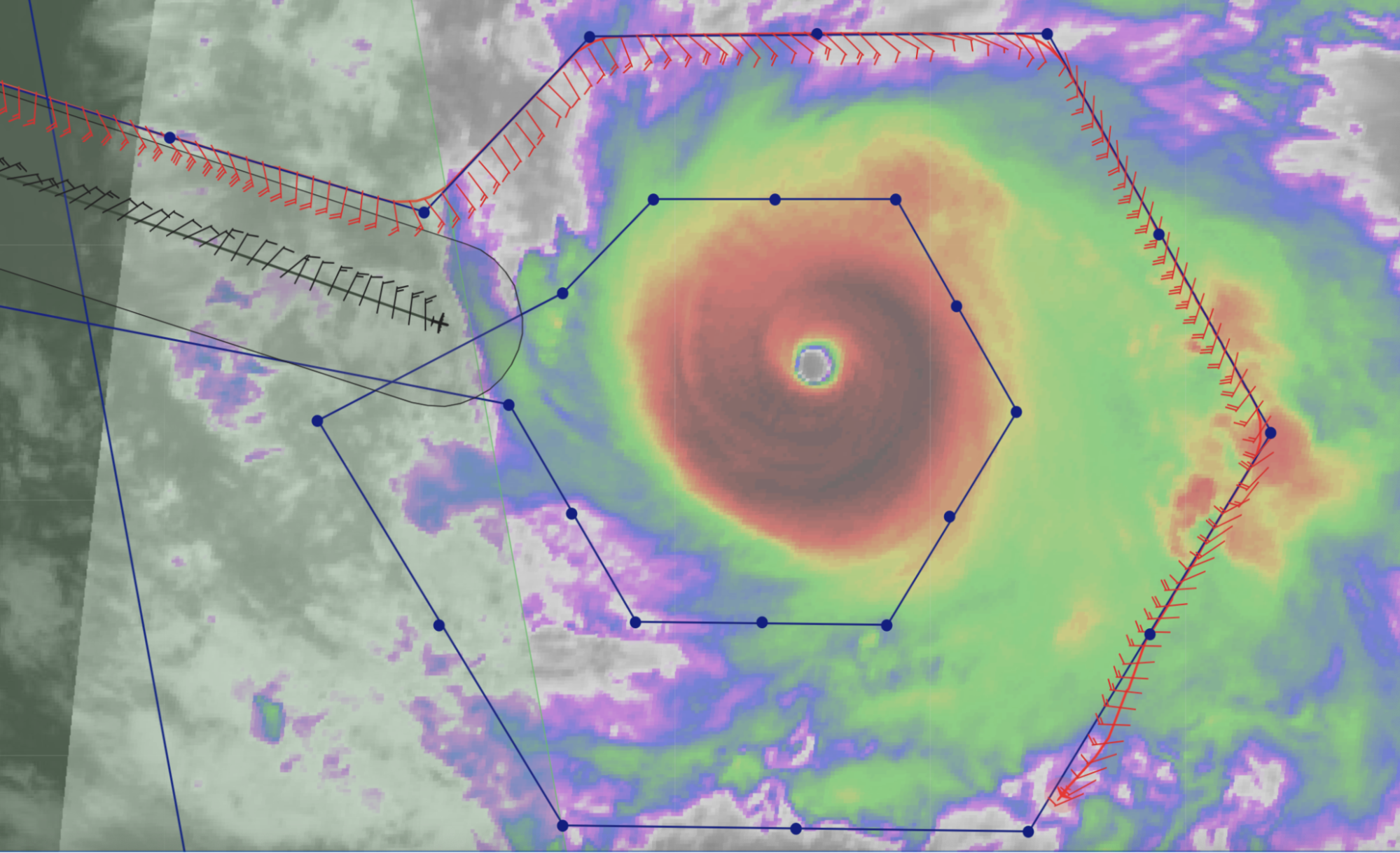
From NHC discussion: “Larry currently has an annular structure, with a 60 n-mi diameter eye and a relatively thick eyewall. High-resolution visible imagery shows several meso-vortices rotating within the eye, which is typically observed in strong hurricanes. The upper-level outflow has become better defined over the western portion of the circulation, indicative of decreased shear in comparison to yesterday. The advisory intensity is kept at 105 kt, in reasonable agreement with the latest Dvorak estimates from TAFB and SAB.” Current satellite imagery:
|
|
Instrument Notes |
[Notes about instrument status prior to the mission] |


|
Time [UTC] |
Event |
|
1448 |
Takeoff from St. Croix |
|
1513 |
En route to Larry… |
|
1618 |
Data comms issues. Everyone on N43 logged off of x-chat. Also, no flight-level wind data showing up in MTS |
|
1630 |
Comms is back. Heather reported that they can see some pretty decent swells propagating towards us (outward from Larry) |
|
1644 |
Crew reported that they can see the curvature in the outer banding as we’re approaching the outer edge of Larry |
|
1654 |
Started descent |
|
1659 |
Quite a few visuals of whitecaps before starting the pattern. SFMR reports ~24 m/s |
|
1703 |
Starting pattern at 10 kft. Combo drop 1 out. SST is 27.5°C which was questioned by the flight crew. It is possible since the storm is near a SST gradient |
|
1709 |
Heading towards the eye |
|
1718 |
Sonde 2, Midpoint inbound pass 1 (2nd sonde) |
|
1722 |
Penetration through the eyewall reported different. Not as defined as usual |
|
1725 |
Hunting the center in the eye (marked at 1326) Gamache gave center fix for radar analyses: 172607, 22.06N, 53.45W |
|
1726 |
Center sonde, pressure of 957.5 mb (3rd sonde) |
|
1731 |
Echo tops are only showing to ~ 5-6 km on the edge of the scans (as going into northern eyewall) |
|
1738 |
Heather reported much broader area of moderate precip on the N side |
|
1744 |
Midpoint outbound sonde. Leg 1 (4th sonde) |
|
1754 |
EP combo drop out (5th sonde), 28.31°C SST. Interesting comparison to SHIPS which has 28.8°C, though there might be a gradient with higher SSTs ahead of storm motion |
|
1821 |
1st ALAMO float released
|
|
1831 |
2nd ALAMO float released |
|
|
Radar analyses from 1st pass
|
|
1853 |
Combo sonde, inbound pass 2 (sonde 6) |
|
1905 |
MP sonde inbound pass 2 (sonde 7) |
|
1912 |
RMW sonde inbound pass 2 (sonde 8, NW eyewall) |
|
|
Once we were inside the reflectivity eye, we hit our worst turbulence of the flight. They wonder if that was one of our mesovortices |
|
1918 |
Center sonde (sonde 9) |
|
1933 |
Midpoint sonde outbound pass 2 (sonde 10) |
|
1940 |
Close overlap between P-3 and G-IV |
|
|
Snapshot from tidbits to highlight the “bounce” the aircraft took during the pass (bottom right plot)
|
|
1945 |
EP combo sonde pass 2 (sonde 11) (26.92°C SST) |
|
|
Last hour of vertical velocities. Very turbulent on the outbound of the previous pass
|
|
1959 |
Midpoint sonde on downwind leg (sonde 12) |
|
2011 |
Initial point (IP) combo drop pass 3 (27.96°SST) – sonde died (sonde 13) |
|
2015 |
Backup IP sonde (sonde 14) |
|
2023 |
Midpoint sonde Inbound leg 3 (sonde 15) |
|
2028 |
RMW sonde inbound leg 3, NW eyewall (sonde 16) |
|
2036 |
Center sonde (sonde 17) |
|
2039 |
Begin Eye-eyewall Mixing Module. Circling eye clockwise |
|
2053 |
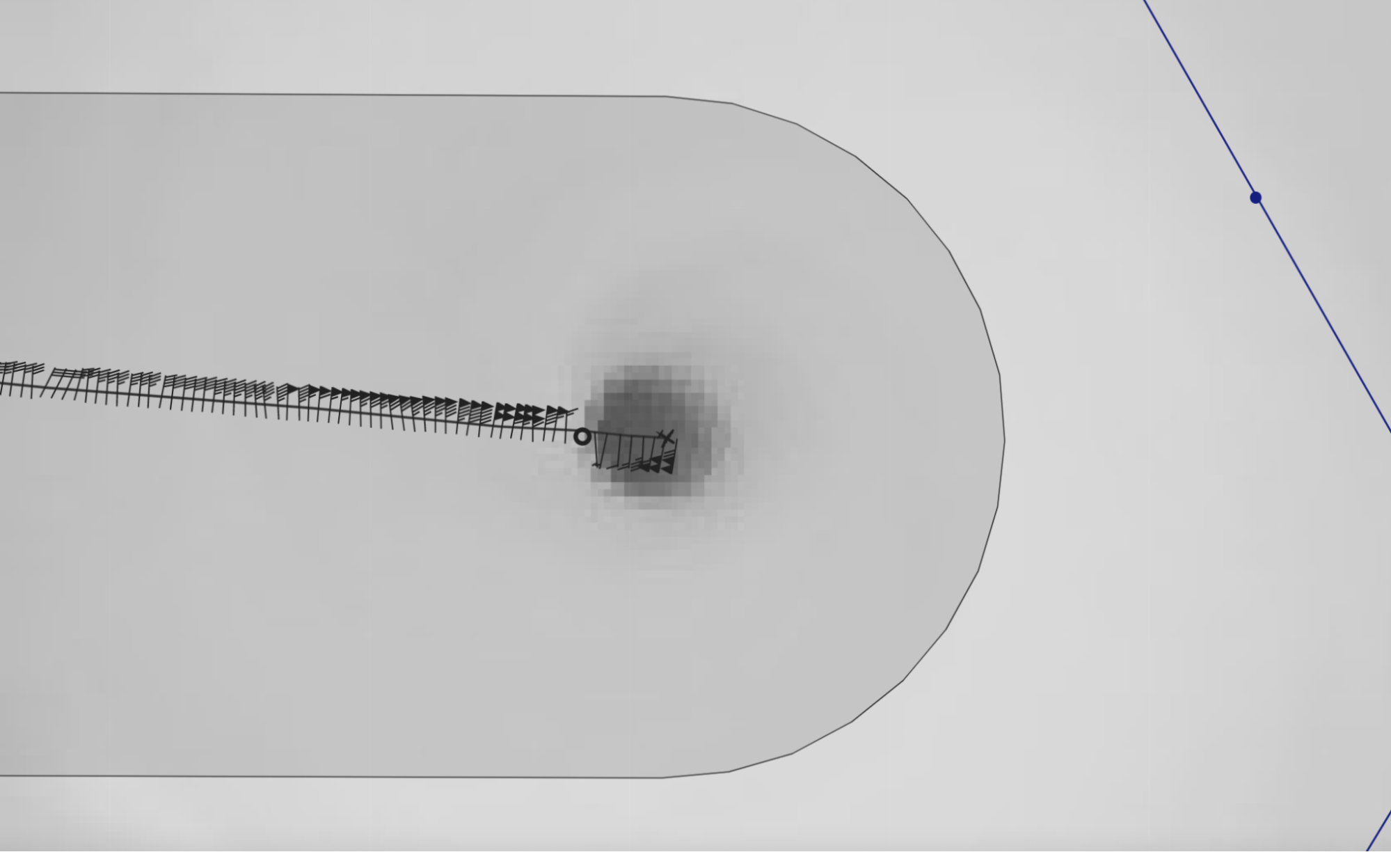
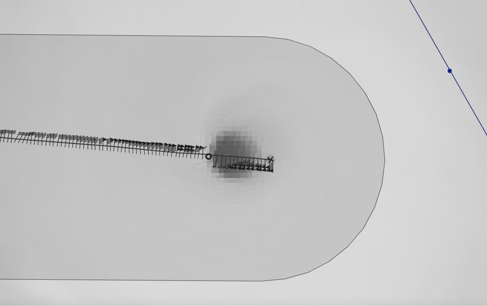
Image captured orbiting the eye |
|
2107 |
Sonde (#18) in mesovortex for Eye-eyewall Mixing Module. Visible imagery is fading, so hard to see where it was
|
|
2116 |
RMW sonde outbound pass 3 (SW eyewall) (sonde 19) |
|
2122 |
Midpoint sonde outbound pass 3 (sonde 20) |
|
2136 |
Endpoint combo sonde (sonde 21) |
|
|
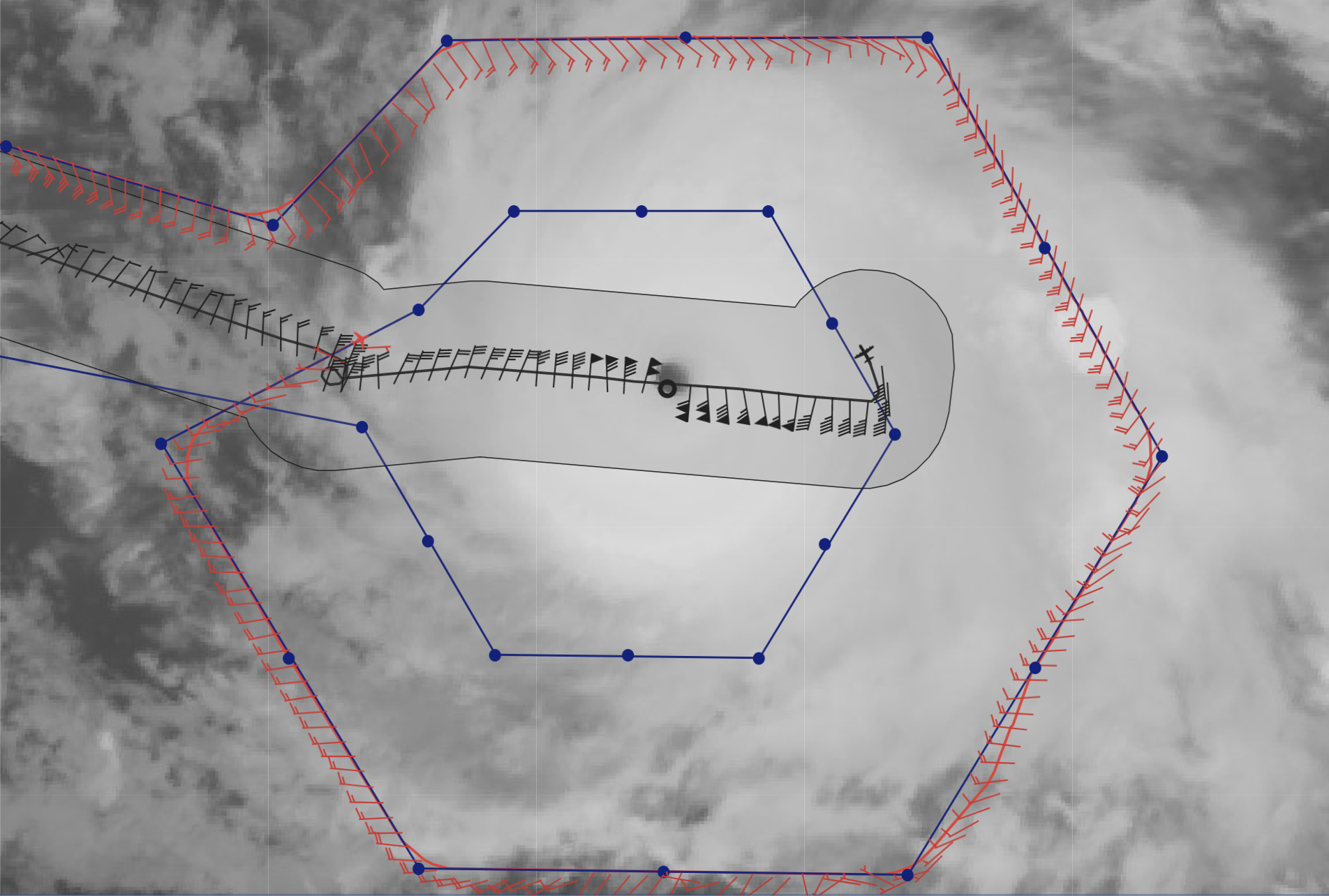
Updated satellite loops at the end of mission |
|
|
KAIA Significant Wave Height from mission
|


|
Mission Summary |
This was a highly successful mission. A butterfly pattern was flown with two ALAMO floats released ahead of the motion after the 1st pass through the center. On the third pass, an Eye-Eyewall Mixing Module was flown which consisted of a clockwise circumnavigation of the eye and a dropsonde in a potential mesovortex. In addition to the standard pattern, three RMW sondes were launched and a center fix was made for each pass for NHC. The radar data was used for the 5 PM ET NHC forecast discussion to discuss surface winds, which we believe is a first. “During that pass through the hurricane, the aircraft tail Doppler radar measured winds of 121 kt at a height of 3 km in the northeastern eyewall, which equate to about 109 kt at the surface. Therefore, the initial intensity has been adjusted up to 110 kt for this advisory. A pair of dropsondes into the eye of Larry measured a minimum central pressure of 956 mb.” 21 total dropsondes were released (14 for EMC, 2 for NHC, 4 for HRD, 1 for ONR), as well as 2 AOML/PhOD ALAMO floats (both failed) and 8 NRL AXBTs (1 bad) |
|
Actual Standard Pattern Flown |
Butterfly + Eye-eyewall Mixing Module |
|
APHEX Experiments / Modules Flown |
Released 2 AOML PhOD ALAMO floats ahead of storm motion, part of the Ocean Observing Experiment: Targeted and Sustained Ocean Observations and flew an Eye-eyewall Mixing Module, part of the Mature Stage Experiment; mission flown in collaboration with ONR TCRI.
|
|
Plain Language Summary |
|
|
Instrument Notes |
An issue with the MMR on N43. The Flight Director said that the one on N43 is worse than on N42. Surface roughness field is ok, but HWX and NAW are bad — lower than expected reflectivity on the MMR. |
|
|
|
|
Mission Flight Data |
|


Mission Summary 20210906I1
|
Tasking ID |
WB12A |
Aircraft |
NOAA43 |
|
Tasked by |
HRD |
Planned pattern |
|
|
Takeoff time |
1447 Z |
Landing time |
2330 Z |
|
Takeoff Location |
St. Croix |
Landing Location |
St. Croix |
|
Flight Time |
8.7 hours |
Block Tine |
8.9 hours |
Expendables
| Real-time Radar Analyses: Total/Transmitted |
3/3 | Dropsondes: Total/Good/Transmitted |
21/20/20 |
|
Ocean Expendables |
|
sUAS |
0 |
Experiments & Modules
|
APHEX Experiments & Modules |
Data & Forms
Crew Lists
Science Crew
| Science Crew Manifest | |||
| Onboard | Ground | ||
|
Lead Scientist(s) |
Holbach |
Lead Scientist(s) |
Wadler |
|
Radar Scientist(s) |
Holbach |
Radar Scientist(s) |
Gamache |
|
Sonde Scientist(s) |
Hazelton |
Sonde Scientist(s) |
None |
|
NESDIS Scientist(s) |
Chang, Jelenak, Sapp |
||
|
Guests (Affiliation) |
None |
||
Aircraft Crew
| Aircraft Crew Manifest | |
|
Pilot(s) |
Didier, Copare, Stateler |
|
Navigator(s) |
Hough, Brian Richards |
|
Flight Engineer(s) |
Darby, Bennet |
|
Flight Director(s) |
Holmes |
|
Data Technician(s) |
Mascaro |
|
AVAPS Tech(s) |
Warnecke |
Flight Log
Mission Summary 20210906N1
|
Tasking ID |
WC12A |
Aircraft |
NOAA49 |
|
Tasked by |
HRD |
Planned pattern |
|
|
Takeoff time |
1545 Z |
Landing time |
2253 Z |
|
Takeoff Location |
St. Croix |
Landing Location |
St. Croix |
|
Flight Time |
6.6 hours |
Block Tine |
6.8 hours |
Expendables
| Real-time Radar Analyses: Total/Transmitted |
3/3 | Dropsondes: Total/Good/Transmitted |
35/35/35 |
|
Ocean Expendables |
0 |
sUAS |
0 |
Experiments & Modules
|
APHEX Experiments & Modules |
Data & Forms
Crew Lists
Science Crew
| Science Crew Manifest | |||
| Onboard | Ground | ||
|
Lead Scientist(s) |
None |
Lead Scientist(s) |
Dunion, O’Neill, Wing |
|
Radar Scientist(s) |
None |
Radar Scientist(s) |
Reasor, Gamache |
|
Sonde Scientist(s) |
Parrish |
Sonde Scientist(s) |
None |
|
NESDIS Scientist(s) |
None |
||
|
Guests (Affiliation) |
None |
||
Aircraft Crew
| Aircraft Crew Manifest | |
|
Pilot(s) |
Mansour, Varwig |
|
Navigator(s) |
None |
|
Flight Engineer(s) |
None |
|
Flight Director(s) |
Kalen, Parrish |
|
Data Technician(s) |
DeFeo |
|
AVAPS Tech(s) |
Greene |
Flight Log
Mission Summary 20210907I1
|
Tasking ID |
WC12A |
Aircraft |
NOAA43 |
|
Tasked by |
NESDIS |
Planned pattern |
Alpha |
|
Takeoff time |
1709 Z |
Landing time |
0108 Z |
|
Takeoff Location |
St. Croix |
Landing Location |
St. Croix |
|
Flight Time |
8.0 hours |
Block Tine |
8.2 hours |
Expendables
| Real-time Radar Analyses: Total/Transmitted |
4/4 | Dropsondes: Total/Good/Transmitted |
5/4/4 |
|
Ocean Expendables |
0 |
sUAS |
0 |
Experiments & Modules
|
APHEX Experiments & Modules |
Data & Forms
Crew Lists
Science Crew
| Science Crew Manifest | |||
| Onboard | Ground | ||
|
Lead Scientist(s) |
Holbach |
Lead Scientist(s) |
Zawislak |
|
Radar Scientist(s) |
Holbach |
Radar Scientist(s) |
Gamache |
|
Sonde Scientist(s) |
Hazelton |
Sonde Scientist(s) |
None |
|
NESDIS Scientist(s) |
Chang, Jelenak, Sapp |
||
|
Guests (Affiliation) |
None |
||
Aircraft Crew
| Aircraft Crew Manifest | |
|
Pilot(s) |
Didier, Copare, Stateler |
|
Navigator(s) |
Hough, Brian Richards |
|
Flight Engineer(s) |
Darby, Bennet |
|
Flight Director(s) |
Holmes |
|
Data Technician(s) |
Mascaro |
|
AVAPS Tech(s) |
Warnecke |
Flight Log
Mission Summary 20210907N1
|
Tasking ID |
WD12A |
Aircraft |
NOAA49 |
|
Tasked by |
HRD |
Planned pattern |
|
|
Takeoff time |
1442 Z |
Landing time |
2155 Z |
|
Takeoff Location |
St. Croix |
Landing Location |
St. Croix |
|
Flight Time |
7.2 hours |
Block Tine |
7.4 hours |
Expendables
| Real-time Radar Analyses: Total/Transmitted |
3/3 | Dropsondes: Total/Good/Transmitted |
35/33/33 |
|
Ocean Expendables |
0 |
sUAS |
0 |
Experiments & Modules
|
APHEX Experiments & Modules |
Data & Forms
Crew Lists
Science Crew
| Science Crew Manifest | |||
| Onboard | Ground | ||
|
Lead Scientist(s) |
None |
Lead Scientist(s) |
Dunion |
|
Radar Scientist(s) |
None |
Radar Scientist(s) |
Reasor |
|
Sonde Scientist(s) |
Parrish |
Sonde Scientist(s) |
None |
|
NESDIS Scientist(s) |
None |
||
|
Guests (Affiliation) |
None |
||
Aircraft Crew
| Aircraft Crew Manifest | |
|
Pilot(s) |
Mansour, Varwig |
|
Navigator(s) |
None |
|
Flight Engineer(s) |
None |
|
Flight Director(s) |
Kalen, Parrish |
|
Data Technician(s) |
DeFeo |
|
AVAPS Tech(s) |
Greene |
Flight Log
Mission Summary 20210925N1
|
Tasking ID |
WA18A |
Aircraft |
NOAA49 |
|
Tasked by |
HRD |
Planned pattern |
|
|
Takeoff time |
1824 Z |
Landing time |
0150 Z |
|
Takeoff Location |
St. Croix |
Landing Location |
St. Croix |
|
Flight Time |
7.4 hours |
Block Tine |
7.6 hours |
Expendables
| Real-time Radar Analyses: Total/Transmitted |
2/2 | Dropsondes: Total/Good/Transmitted |
32/29/29 |
|
Ocean Expendables |
0 |
sUAS |
0 |
Experiments & Modules
|
APHEX Experiments & Modules |
Data & Forms
Crew Lists
Science Crew
| Science Crew Manifest | |||
| Onboard | Ground | ||
|
Lead Scientist(s) |
None |
Lead Scientist(s) |
None |
|
Radar Scientist(s) |
None |
Radar Scientist(s) |
Reasor |
|
Sonde Scientist(s) |
Flaherty |
Sonde Scientist(s) |
None |
|
NESDIS Scientist(s) |
None |
||
|
Guests (Affiliation) |
None |
||
Aircraft Crew
| Aircraft Crew Manifest | |
|
Pilot(s) |
Norman, de Triquet |
|
Navigator(s) |
None |
|
Flight Engineer(s) |
None |
|
Flight Director(s) |
Paul Flaherty, Kalen |
|
Data Technician(s) |
Gabe Defeo |
|
AVAPS Tech(s) |
Patel |
Flight Log
Pre-Flight
Post-Flight
| POST-FLIGHT 20210927H1 |
|||||||||||||
|
|||||||||||||
Mission Summary 20210925H1
|
Tasking ID |
WB18A |
Aircraft |
NOAA42 |
|
Tasked by |
HRD/ONR/TCRI |
Planned pattern |
|
|
Takeoff time |
1848 Z |
Landing time |
0311 Z |
|
Takeoff Location |
St. Croix |
Landing Location |
St. Croix |
|
Flight Time |
8.4 hours |
Block Tine |
8.6 hours |
Expendables
| Real-time Radar Analyses: Total/Transmitted |
3/3 | Dropsondes: Total/Good/Transmitted |
34/31/31 |
|
Ocean Expendables |
8 ONR AXBT 2 Navy ALAMO |
sUAS |
None |
Experiments & Modules
|
APHEX Experiments & Modules |
Data & Forms
Crew Lists
Science Crew
| Science Crew Manifest | |||
| Onboard | Ground | ||
|
Lead Scientist(s) |
Bucci |
Lead Scientist(s) |
Zawislak |
|
Radar Scientist(s) |
Bucci |
Radar Scientist(s) |
Gamache |
|
Sonde Scientist(s) |
J. Zhang |
Sonde Scientist(s) |
None |
|
NESDIS Scientist(s) |
None |
||
|
Guests (Affiliation) |
None |
||
Aircraft Crew
| Aircraft Crew Manifest | |
|
Pilot(s) |
Legidakes, Keith, Rannenberg |
|
Navigator(s) |
Hough, Utama |
|
Flight Engineer(s) |
Sanchez, Levine |
|
Flight Director(s) |
Hathaway, Lundry |
|
Data Technician(s) |
T. Richards |
|
AVAPS Tech(s) |
McAllister |
Flight Log
Pre-Flight
| PRE-FLIGHT 20210925H1 |
|
|
Flight Plan |
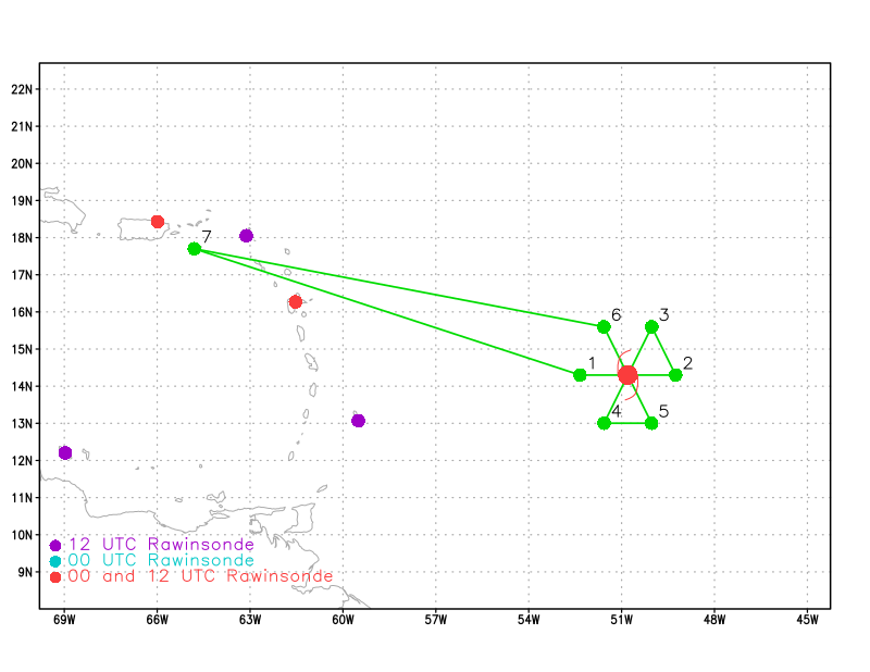
The planned pattern is for a 70 nmi butterfly with a brief module northwest of the storm to release 2 Navy ALAMO floats (at a location 24 hours in advance of the passage of the storm center track). Altitude in pattern and for ALAMO releases will be 10 kft.
|
|
Expendable Distribution |
Dropsondes to be released at the endpoints (EMC), midpoints (EMC), center (EMC), and RMWs on each inbound and outbound (6 charged to EMC, the remainder to ONR TCRI). Another sonde will be released in combo with an ONR AXBT between the ALAMO releases. ONR AXBTs will be released at each endpoint, once in the center (if possible), and once between the 2 Navy ALAMO releases.
|
|
Preflight Weather Briefing |
As of the 2 PM EDT NHC advisory, Hurricane Sam is located near 12.9N / 47.6W, has an estimated max sustained winds of 105 kt, MSLP of 960 mb, and is moving west-northwest at 9 kt. Over the past 24 hours, Sam has continued to rapidly intensify. The inner core continues to gain symmetry as it is no longer somewhat constricted on the west side of the storm and there is a complete ring of deep convection around the center. The eye has also been progressively clearing over the past few hours. It’s possible the storm is continuing to intensify, though this mission will collect the first in-situ data from the center of the storm. The environment remains very favorable for rapid intensification, with possibly only a slight cool ocean eddy and eyewall replacement cycles being the limiting factor for further intensification today.
|
|
Instrument Notes |
None notable |


In-Flight
| IN-FLIGHT 20210925H1 |
|
|
Time [UTC] |
Event |
|
1848 |
Takeoff from St. Croix |
|
2057 |
Potential fortuitous Aeolus overpass validation as Aeolus will be passing just west of the storm at 2121Z. The G-IV dropsondes on the W and SW side of the inner circumnav will be after the satellite passes overhead by 45 min – 1 hour, but will be in the footprint of the satellite.
|
|
2105 |
Will attempt to work in an Aeolus validation sonde near 50.5W on their ferry, which would be released just inside 125 nmi from the Aeolus footprint about 15 min after the satellite comes over head:
|
|
2121 |
ADM-Aeolus passed the storm (green cross in screenshot)
|
|
2130 |
In the 5 PM EDT advisory, NHC upgraded Sam to 120 kt, 943 mb, and is located near 13.3N/48.5W. |
|
2135 |
Sonde #1 [HRD1] released for ADM-Aeolus validation just inside of the 125 nmi edge of the descending footprint of the satellite. Still with thinnish cirrus overhead before getting under the thicker dense overcast. Screenshot below near time of release…
|
|
2143 |
Descending to get to IP to do first inbound from the west |
|
2149 |
Combo drop / Arrive at IP / Released ahead of convective line (Sonde #2 [EMC1], ONR AXBT #1). SST 28.5 sfc 17 kts dir 025 |
|
2201 |
SMRF values look suspect |
|
2159 |
West mid pt drop (Sonde #3 [EMC2]) |
|
2204 |
First RMW W (Sonde #4 [EMC3]) |
|
2206 |
Second RMW W (Sonde #5 [ONR1]) |
|
2207 |
Third RMW W (Sonde #6 [ONR2]) |
|
2207 |
Center Combo (Sonde #7 [EMC4]; ONR AXBT #2). No SST from center BT. |
|
2209 |
As expected, very tight wind gradient!
|
|
2209 |
First RMW E (Sonde #8 [EMC5]) |
|
2210 |
Second RMW E (Sonde #9 [ONR3]) |
|
2215 |
East mid pt drop (Sonde #10 [EMC6]) |
|
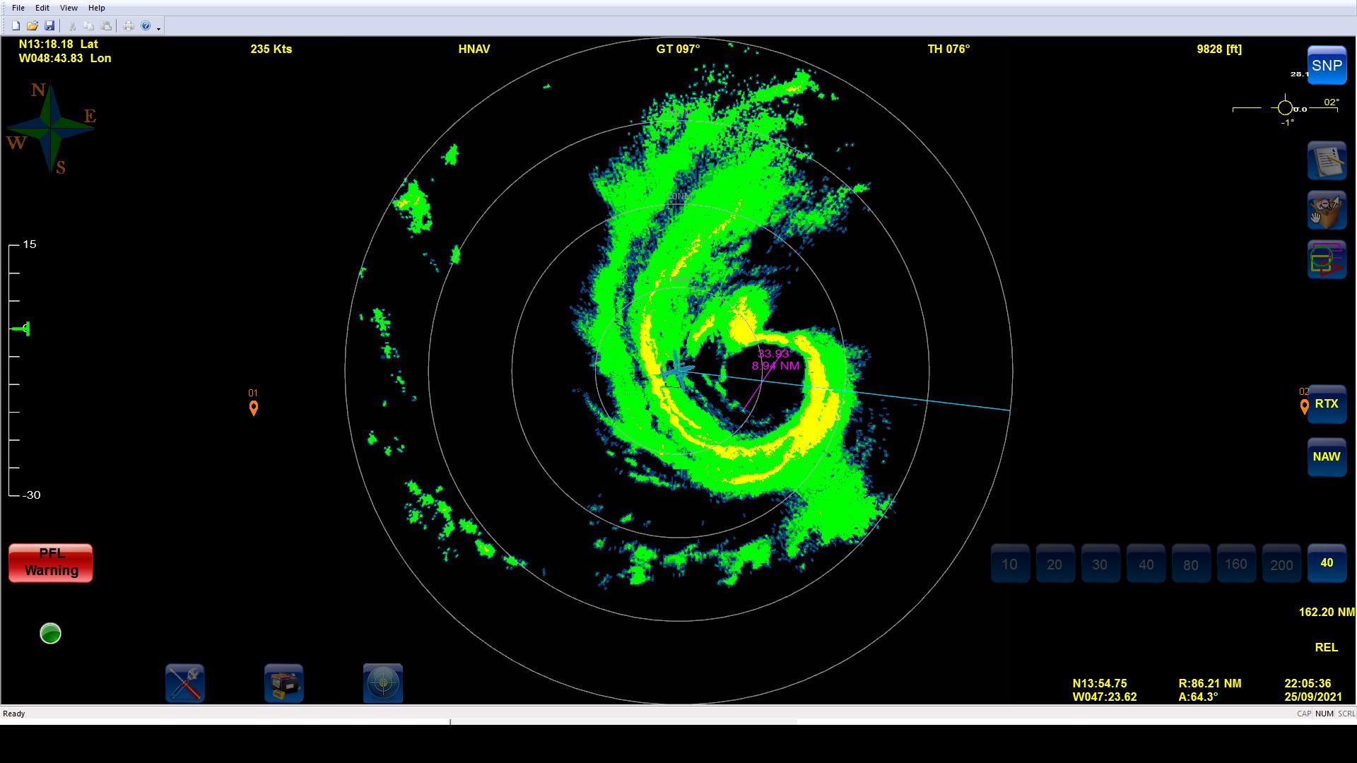
2221 |
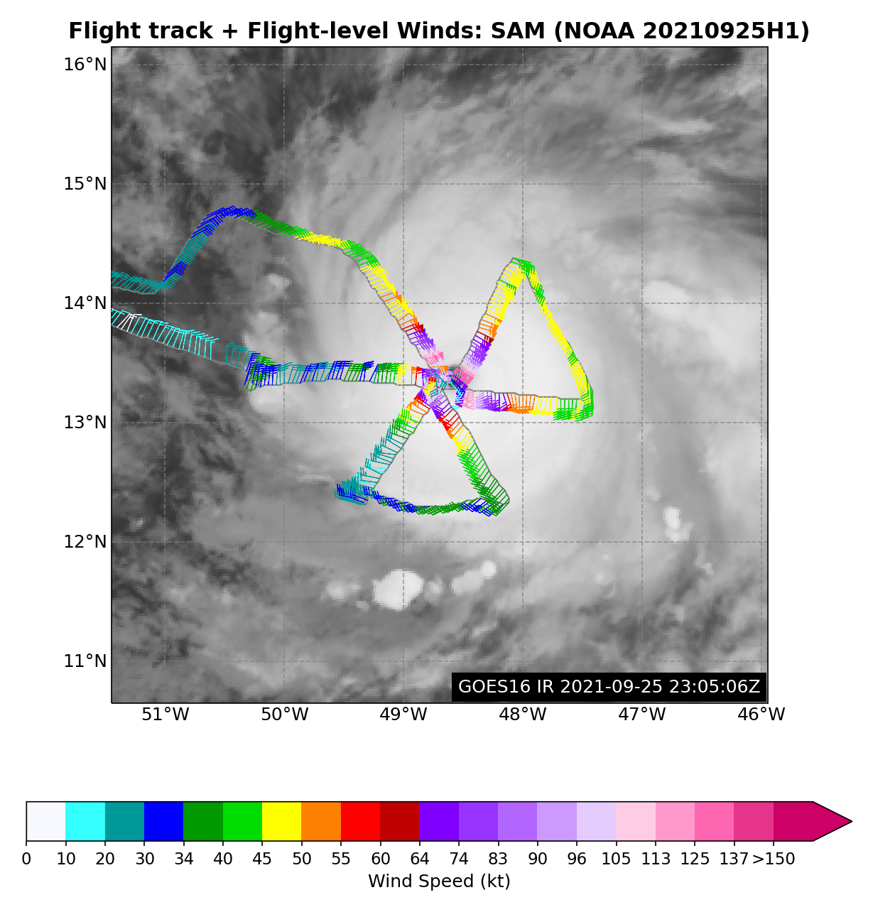
Extrapolated MSLP was 942 mb and the 10-sec SFMR winds peak outbound were 133 kt, although there was an instantaneous measurement of 140 kt. Center sonde splash at 945 with 9 kt of wind. |
|
2223 |
Endpoint east (Sonde #11 [EMC7]; ONR AXBT #3). SST 27.8C |
|
2227 |
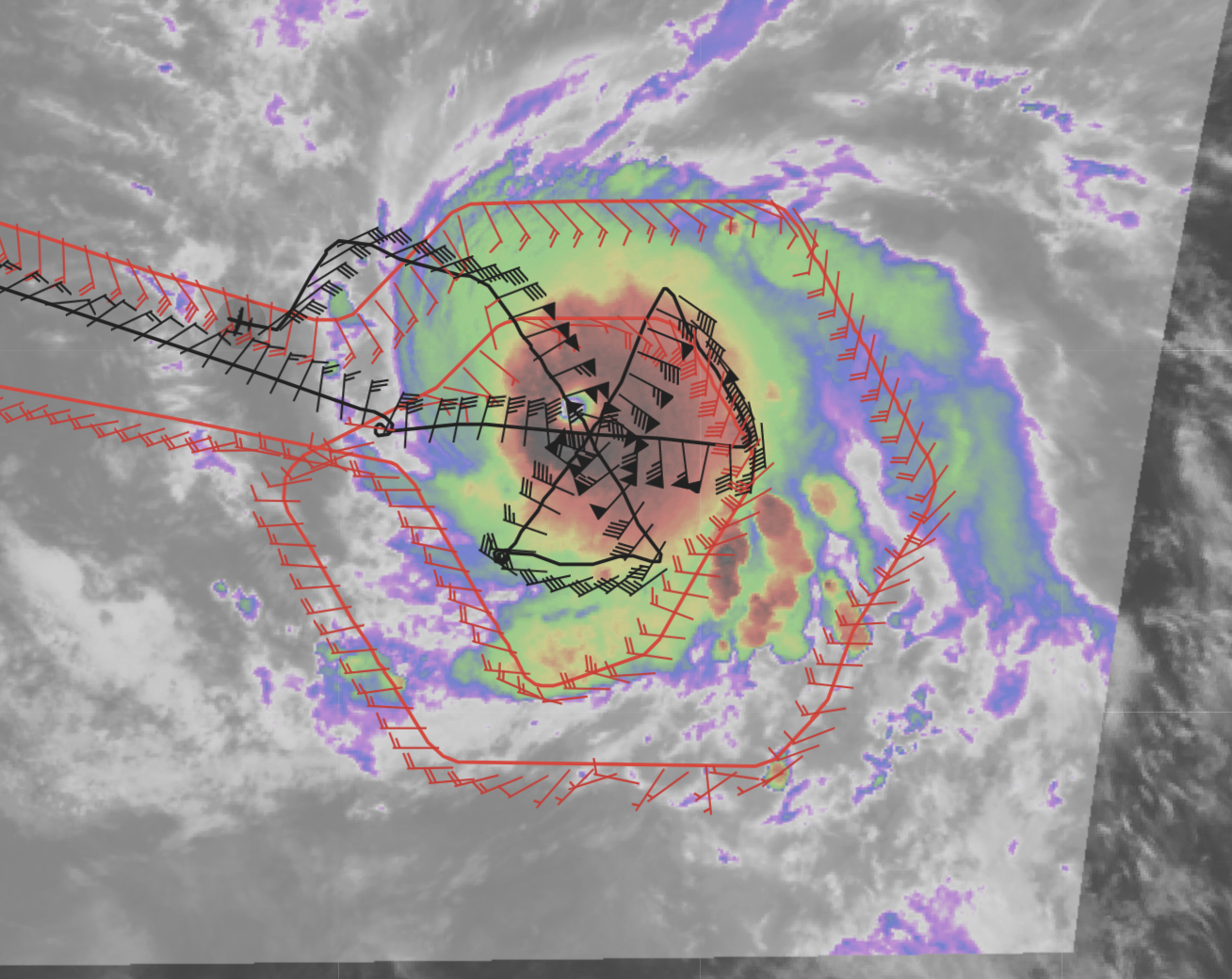
A look at the first pass as the G-IV arrives into the inner circumnavigation
|
|
2237 |
New points for the Navy ALAMO releases: 14.66N / 50.73W and 14.15N / 51.05W |
|
2245 |
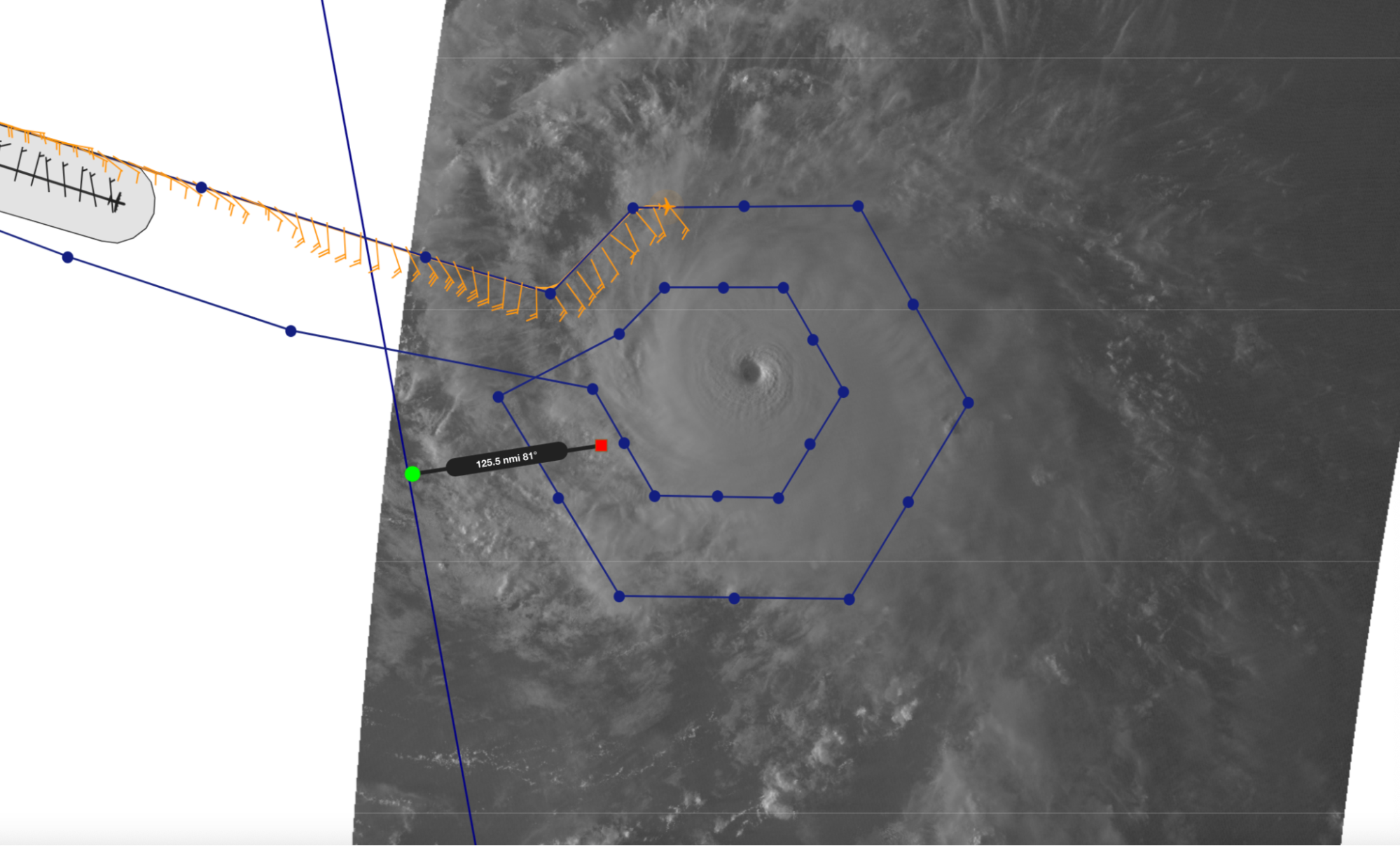
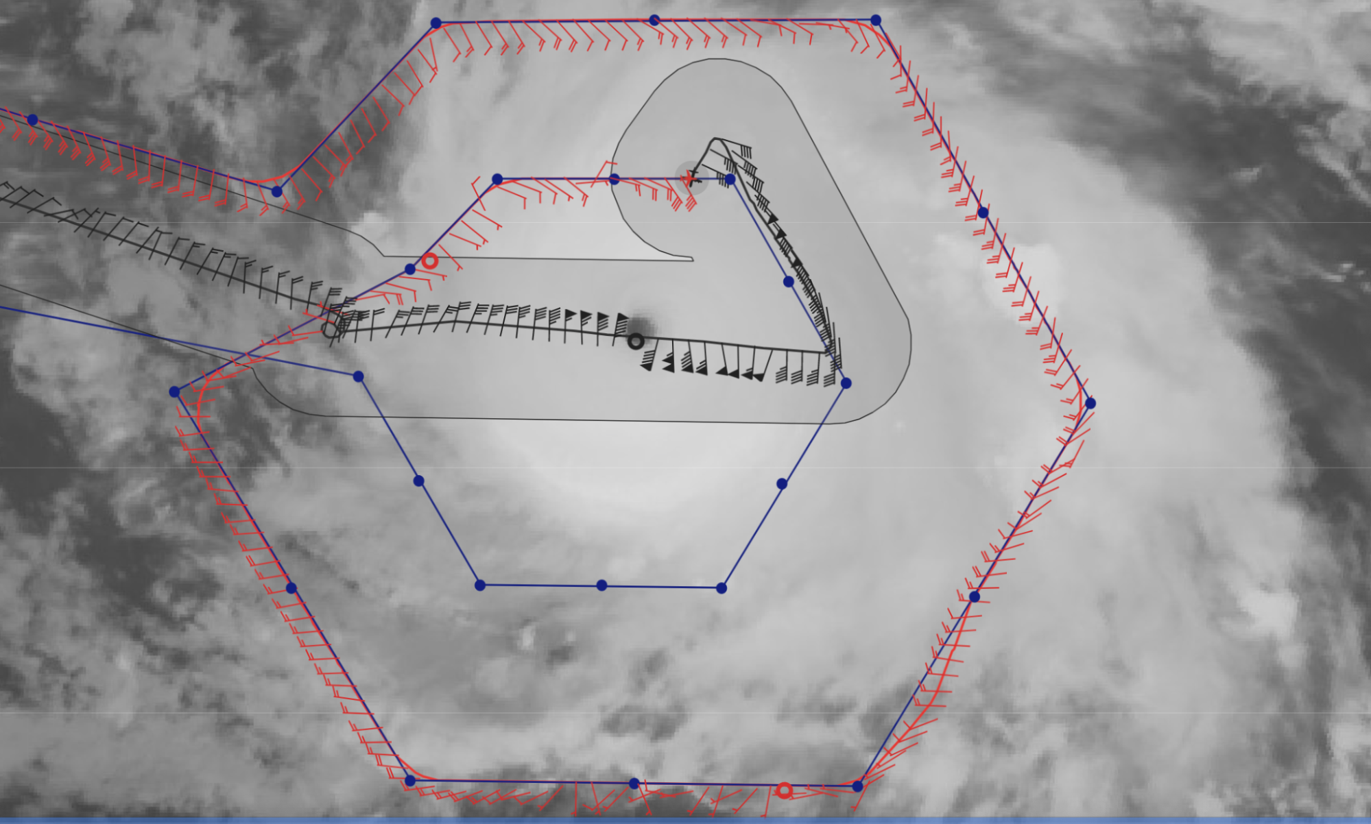
The G-IV and P-3 are right on top of one another as the P-3 heads inbound to the center from the NE and the G-IV is on the northern portion of its inner circumnav.
|
|
2242 |
IP northeast (Sonde #12 [EMC8]; ONR AXBT #4). SST 27.9C |
|
2251 |
Northeast mid pt (Sonde #13 [EMC9]) — No launch detect, but there are data that can be reprocessed |
|
2255 |
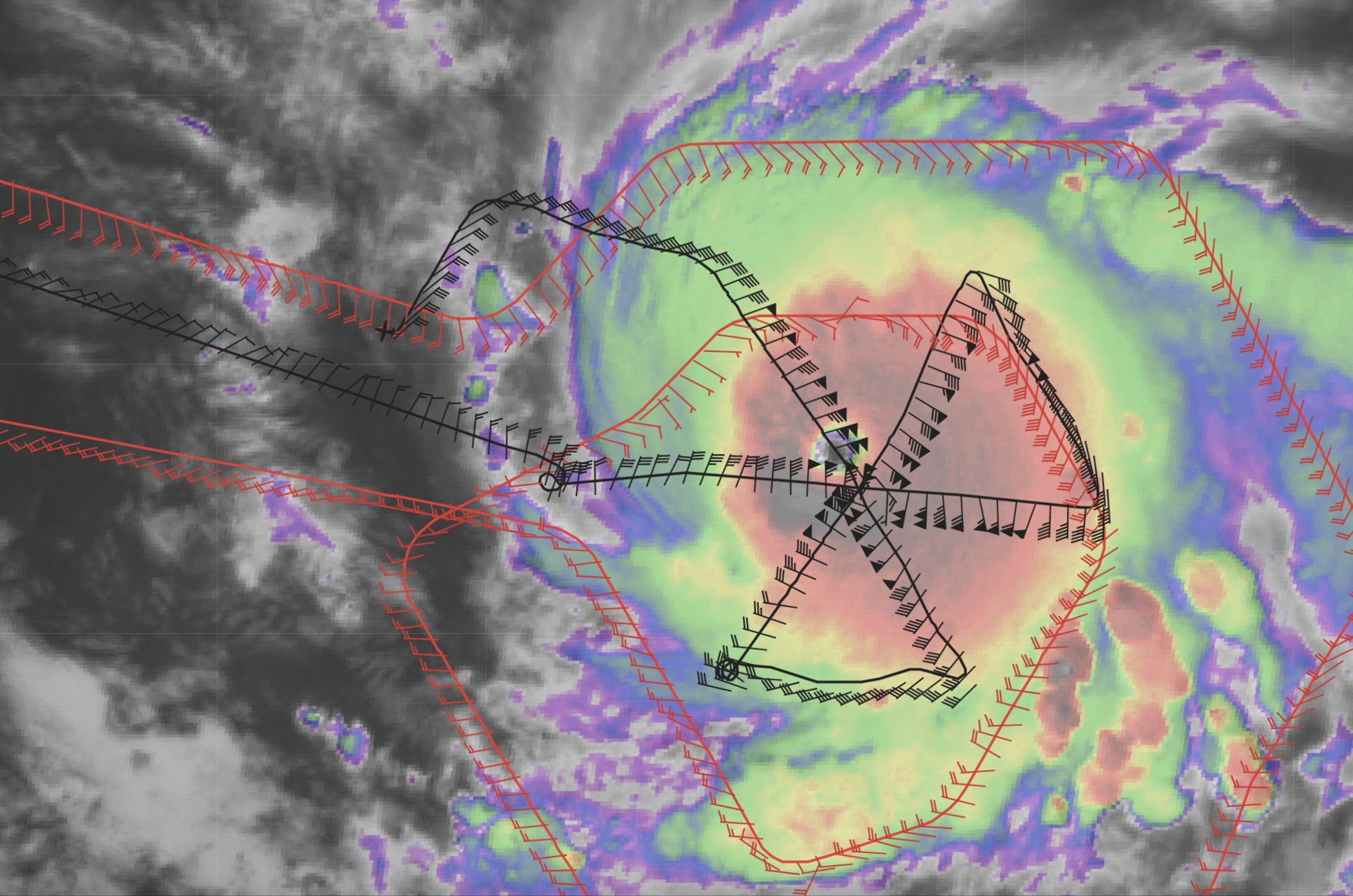
A look at the MMR inbound from the west on the first pass. Reports from the plane were significant turbulence outbound with graupel. Lots of lightning, as well, so pretty significant convection as seen in the satellite imagery below from the first pass.
|
|
2257 |
First RMW NE (Sonde #14 [EMC10]), Second RMW NE (Sonde #15 [ONR4]), Third RMW NE (Sonde #16 [ONR5]) |
|
2259 |
Center #2 (Sonde #17 [EMC11]) |
|
2301 |
First RMW SW (Sonde #18 [EMC12]), Second RMW SW (Sonde #19 [ONR6]), Third RMW SW (Sonde #20 [ONR7]) |
|
2307 |
A look at the 2nd pass of the center from NE to SW
|
|
2308 |
SW midpoint (Sonde #21 [EMC13]) |
|
2312 |
The maximum inbound surface wind was 136 kt! Still extrapolated MSLP of 942 mb. |
|
2322 |
Circling to give AVAPS a moment to reset |
|
2323 |
SW endpoint combo (Sonde #22 [EMC14]; ONR AXBT #5) |
|
2330 |
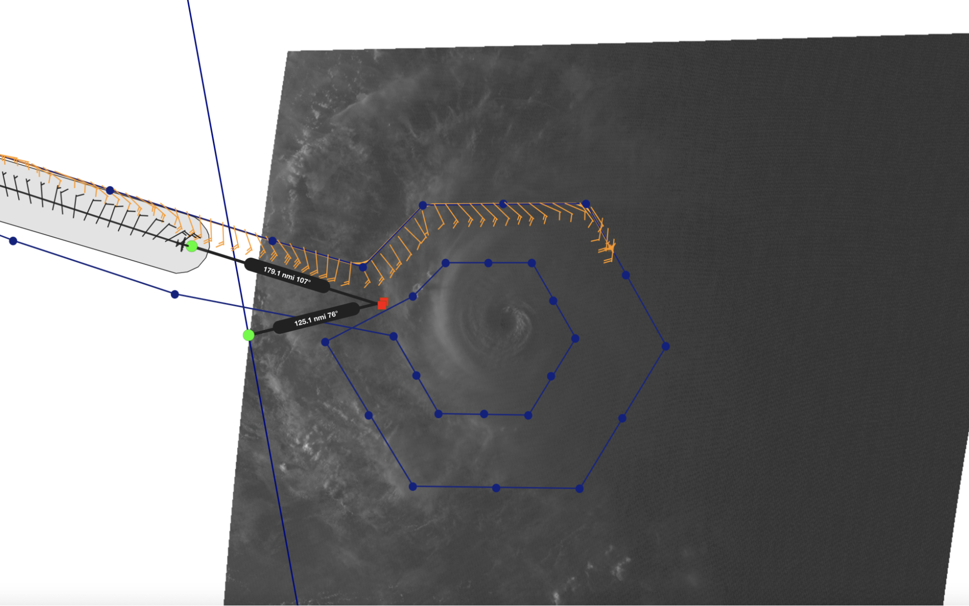
P-3 now downwind headed towards its last pass as the G-IV is on the SW side in close vicinity to the P-3 as it nears completion of the inner circumnav.
|
|
2333 |
Looks like the storm has about a 7-8 n mi RMW |
|
2337
|
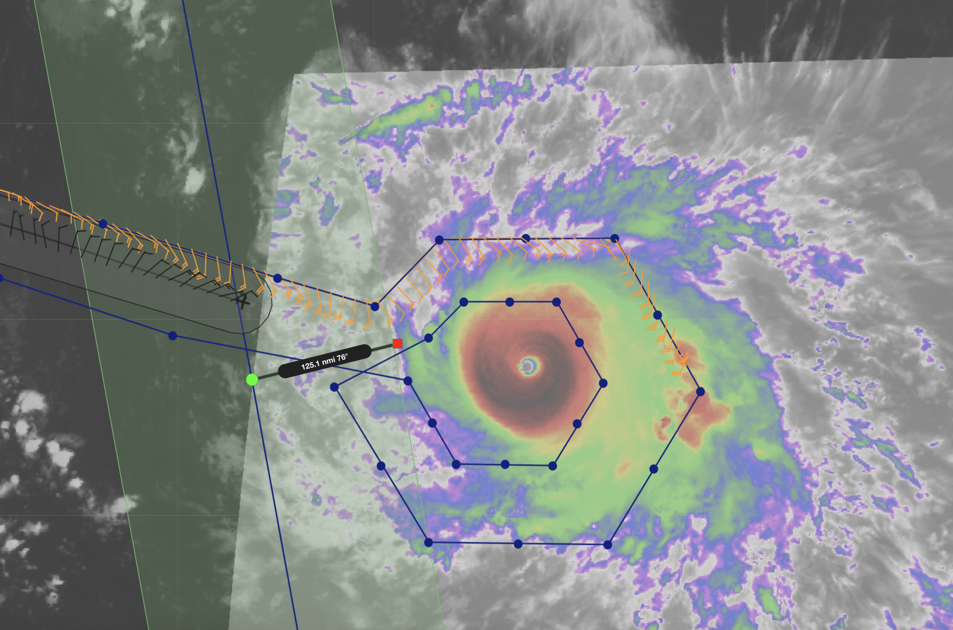
G-IV has completed the inner circumnav as the P-3 heads downwind for its final pass.
|
|
2340 |
SE IP (Sonde #23 [EMC15]; ONR AXBT #6) |
|
2349 |
SE midpoint (Sonde #24 [EMC16]) |
|
2355-2356 |
First RMW SE (Sonde #25 [EMC17]), Second RMW SE (Sonde #26 [ONR8]), Third RMW SE (Sonde #27 [ONR9]) |
|
2357 |
Center #3 (Sonde #28 [EMC18]) |
|
2358 |
First RMW NW (Sonde #29 [EMC19]), Second RMW NW (Sonde #30 [ONR10]), Third RMW NW (Sonde #31 [ONR11]) |
|
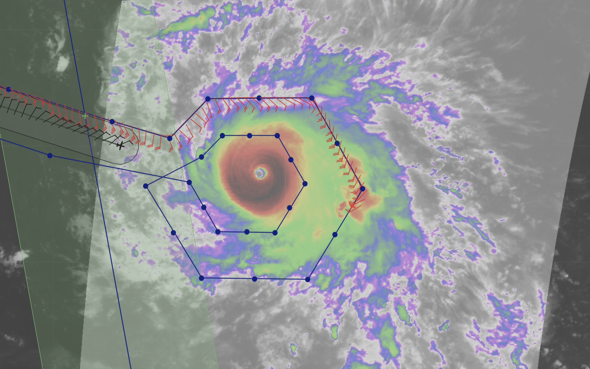
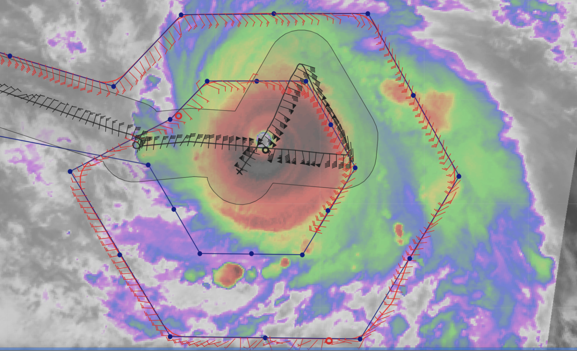
0002 |
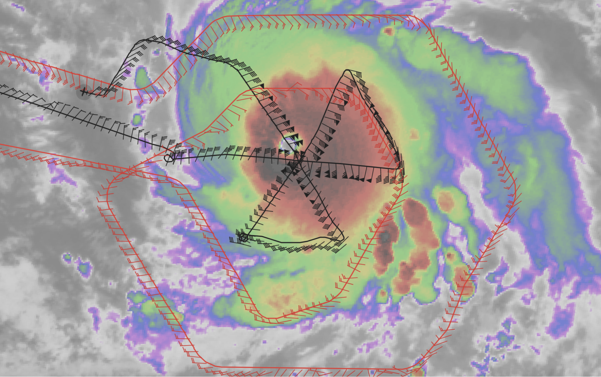
A look at the third and final pass of the center as reports from the P-3 were that they once again hit graupel. There has been plenty of inner core lightning during the flight.
|
|
0005 |
NW midpoint (Sonde #32 [EMC20]), at the edge of the precip shield |
|
0012 |
The P-3 has completed the butterfly pattern and is now headed towards the ALAMO and AXBT deployments.
|
|
0012 |
NW Endpoint (Sonde #33 [EMC21]; ONR AXBT #7) |
|
0031 |
Navy ALAMO 1 out — 14 39.9’N 50 43.6’W, true air speed (TAS) 250 kt, FL wind 30 kt
|
|
|
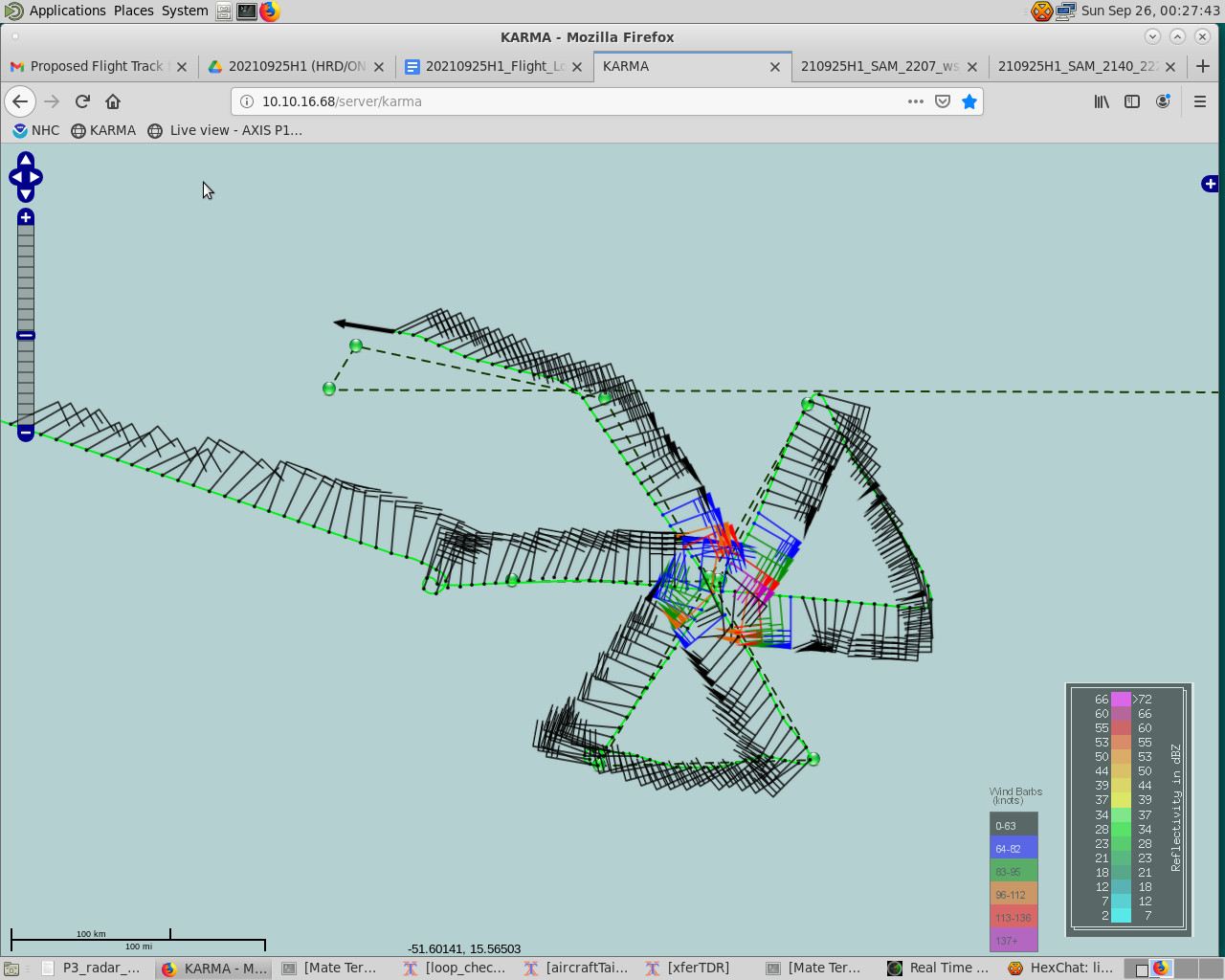
Test screenshot upload from Karma — it worked!
|
|
0035 |
Between ALAMO releases, Sonde #34 [ONR12]; ONR AXBT #8 |
|
0038 |
Navy ALAMO 2 out — 14 8.0’N 51 3.6’W, TAS 251 kt, FL wind 27 kt
|
|
0039 |
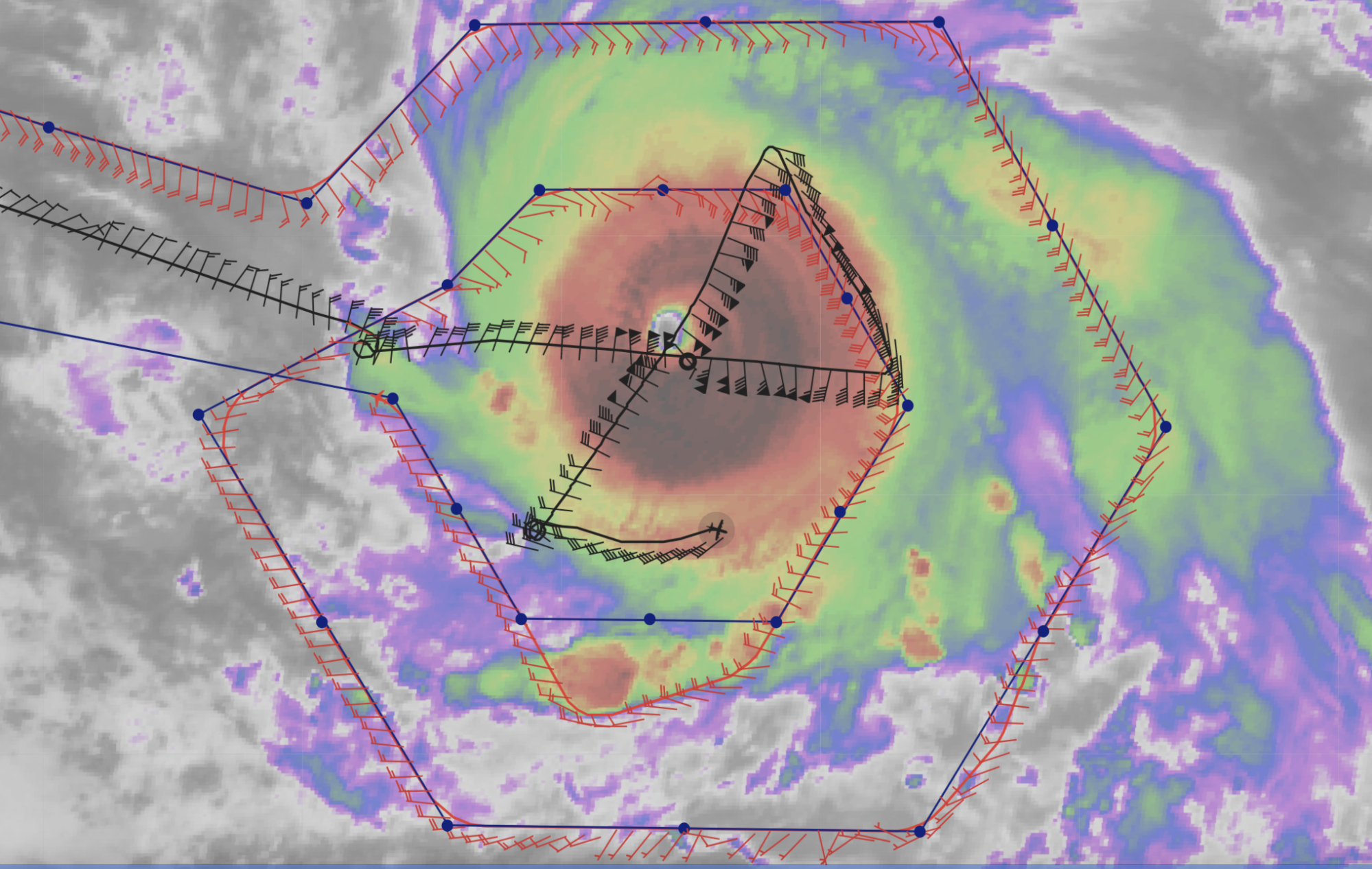
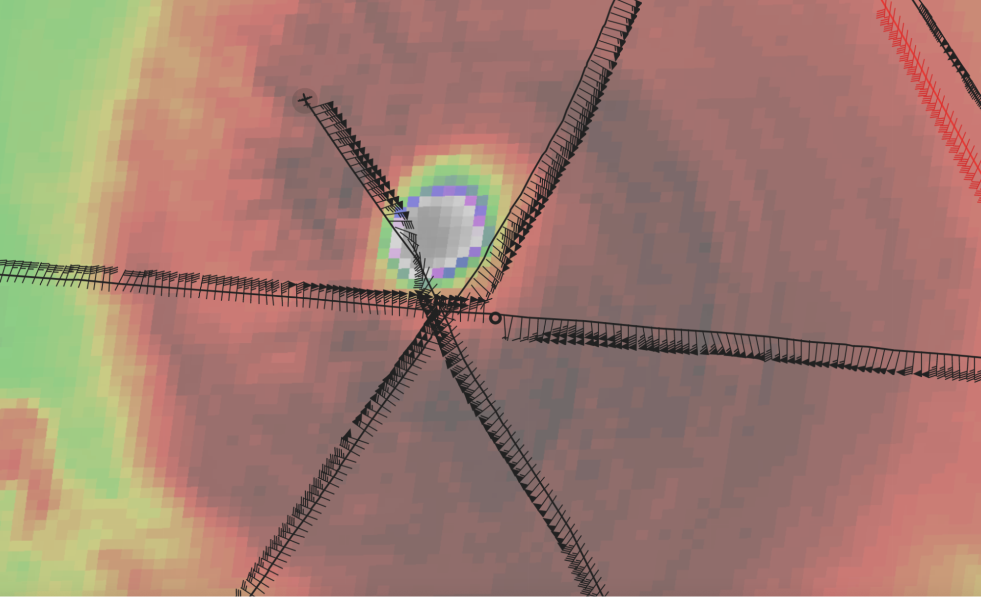
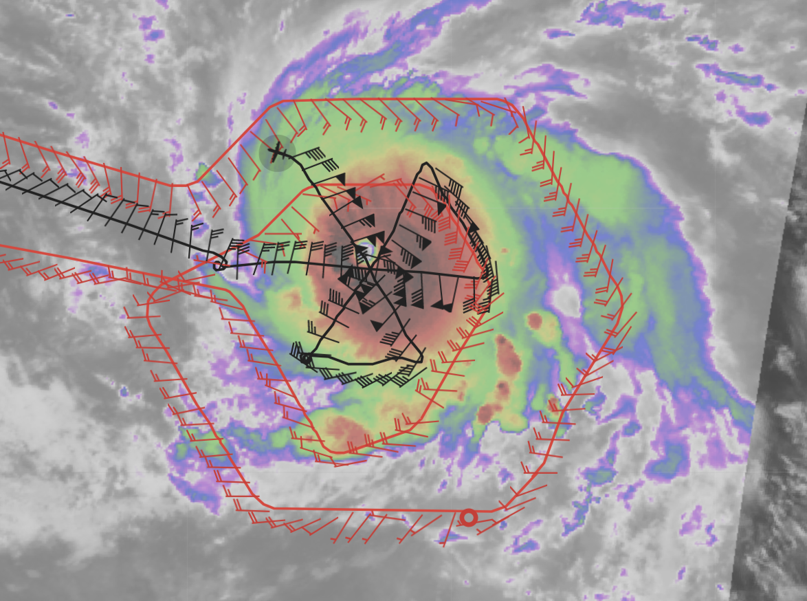
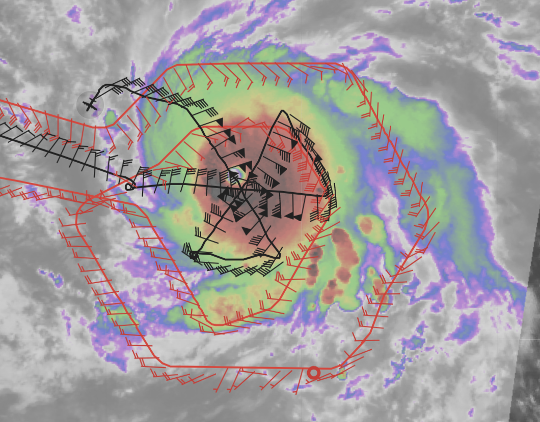
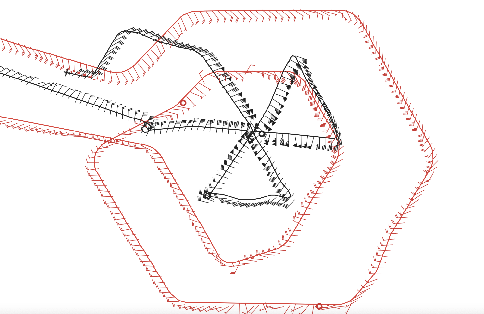
Pattern complete:
The final satellite loops encompassing the mission:
And the final TDR composites from the mission:
|


Post-Flight
| POST-FLIGHT 20210925H1 |
|
|
Mission Summary |
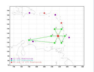
This flight perhaps captured the end of what has been a very impressive period of rapid intensification for Sam as the MSLP was consistently 943-945 mb. The peak surface winds were up above 140 kt (observed on the NE inbound and NW outbound), with some impressive dropsondes showing up to nearly 200 kt winds at 900 mb, and 162 kt surface winds in a SE eyewall sonde that translated to the NE quadrant. Convection was vigorous throughout the mission, with plenty of inner core lightning and graupel and turbulence reported by the crew. Dry air appears to be ~40 n mi outside of the core in the northwest quadrant which could be limiting convection. The mission successfully dropped almost all planned sondes, all planned ONR AXBTs, and the two Navy ALAMO floats, meeting all of the APHEX-AIPEX and ONR TCRI goals. An additional ADM-Aeolus validation module was planned on the fly as Aeolus passed just west of the storm around 2121Z; an improvised sonde was released from the P-3 at 2135Z in the Aeolus footprint, about 15 min after its passage. 34 total dropsondes released (31 of them good and transmitted; 21 charged to NWS, 12 charged to ONR, and 1 charged to HRD) 8 ONR AXBTs released; all good 2 Navy ALAMO floats deployed
|
|
Actual Standard Pattern Flown |
Butterfly with 70 n mi radial legs at 10 kft |
|
APHEX Experiments / Modules Flown |
Ocean Observing: Sustained and Targeted Observations; Satellite Validation: ADM-Aeolus; flown in collaboration with ONR TCRI |
|
Plain Language Summary |
|
|
Instrument Notes |
|
|
Final Mission Track |
P3 track
P3 + G-IV tracks
|


Mission Summary 20210926H1
|
Tasking ID |
0218A |
Aircraft |
NOAA42 |
|
Tasked by |
EMC/ONR/TCRI |
Planned pattern |
|
|
Takeoff time |
1942 Z |
Landing time |
0414 Z |
|
Takeoff Location |
St. Croix |
Landing Location |
St. Croix |
|
Flight Time |
8.1 hours |
Block Tine |
8.5 hours |
Expendables
| Real-time Radar Analyses: Total/Transmitted |
3/3 | Dropsondes: Total/Good/Transmitted |
34/34/34 |
|
Ocean Expendables |
None |
sUAS |
None |
Experiments & Modules
|
APHEX Experiments & Modules |
Data & Forms
Crew Lists
Science Crew
| Science Crew Manifest | |||
| Onboard | Ground | ||
|
Lead Scientist(s) |
Bucci |
Lead Scientist(s) |
Zawislak |
|
Radar Scientist(s) |
Bucci |
Radar Scientist(s) |
Gamache |
|
Sonde Scientist(s) |
J. Zhang |
Sonde Scientist(s) |
None |
|
NESDIS Scientist(s) |
None |
||
|
Guests (Affiliation) |
None |
||
Aircraft Crew
| Aircraft Crew Manifest | |
|
Pilot(s) |
Legidakes, Keith, Rannenberg |
|
Navigator(s) |
Hough, Utama |
|
Flight Engineer(s) |
Sanchez, Levine |
|
Flight Director(s) |
Hathaway, Lundry |
|
Data Technician(s) |
T. Richards |
|
AVAPS Tech(s) |
McAllister |
Flight Log
Pre-Flight
| PRE-FLIGHT 20210926H1 |
|
|
Flight Plan |
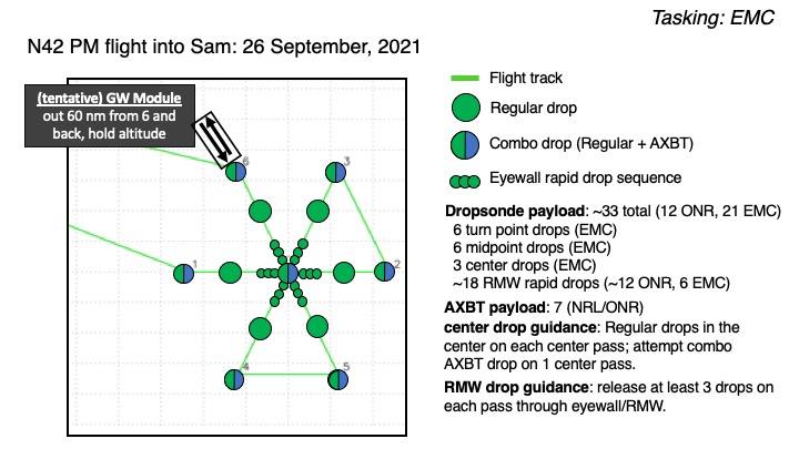
The planned pattern is for a 90 n mi butterfly with an additional Gravity Wave Module to the NW at the completion of the pattern. Altitude will be 10 kft.
|
|
Expendable Distribution |
Dropsondes to be released at the endpoints (EMC), midpoints (EMC), center (EMC), and RMWs on each inbound and outbound (6 charged to EMC, the remainder to ONR TCRI). ONR AXBTs will be released at each endpoint, and once in the center (if possible).
|
|
Preflight Weather Briefing |
As of the 11 AM EDT NHC Advisory, Hurricane Sam was located near 13.9N / 50.2W, had an estimated max wind of 125 kt, MSLP of 943 mb, and was moving west-northwest at 7 kt. Since yesterday, it appears that the storm has more or less been in a steady state, though the inner core continues to exhibit an impressive ring of deep convection and clear eye. The environment continues to be favorable for the storm to maintain its intensity, and perhaps strengthen some (though it is fairly close to its maximum potential intensity), though eyewall replacement cycles are certainly possible and could temporarily weaken the storm. It’ll be interesting to see whether this flight observes secondary eyewall formation.
|
|
Instrument Notes |
All instruments up and functioning. WSRA received a software update to potentially fix a bad data processing from yesterday’s flight. |

In-Flight
| IN-FLIGHT 20210926H1 |
|
|
Time [UTC] |
Event |
|
1941 |
Take off from STIX / 2 h until begin pattern |
|
2045 |
5 PM NHC Advisory: 14.2N / 50.5W, 130 kt, 938 mb, moving northwest at 6 kt: “Sam has found a way to strengthen some more today. The ring of intense convection surrounding the 15-n-mi-diameter eye has expanded in size over the past several hours, while cloud tops colder than -70C still completely surround the center. An earlier GMI microwave overpass revealed very strong eyewall convection tightly wrapped around the small eye, a feature oftentimes seen with intense hurricanes. The latest Dvorak intensity estimates from TAFB and SAB |
|
2053
|
Screenshot below shows the Aeolus track, which will pass by the storm around 2134 UTC. The P-3 will reach the 125 n mi eastern edge about 184 n mi from the center. G-IV has had to deviate around an outer band to target their sondes to the south of the storm.
|
|
2133 |
Aeolus just passed near the P-3 and just west of the storm.
|
|
2159 |
Pattern shifted a little east to center it on the eye (from SS mode on MMR)
|
|
2215 |
IP West (Sonde #1 [EMC1]; ONR AXBT #1). SST 28.4°C Sonde incorrectly processed. |
|
2225 |
G-IV now in the inner circumnav as the P-3 approaches the midpoint of the inbound from the west. Precipitation only extends to about that midpoint on the west side.
|
|
2226 |
MP West (Sonde #2 [EMC2]) |
|
2235 |
First RMW West (Sonde #3 [EMC3]) |
|
2235 |
Second RMW West (Sonde #4 [ONR1]) |
|
2236 |
Third RMW West (Sonde #5 [ONR2]) |
|
2237 |
Center #1 (Sonde #6 [EMC4]; ONR AXBT #2); 937 mb splash, 110deg./41 kt surface winds |
|
2238 |
First RMW East (Sonde #7 [EMC5]) |
|
2239 |
Second RMW East (Sonde #8 [ONR3]) |
|
2239 |
Third RMW East (Sonde #9 [ONR4]) |
|
2242 |
A look at the first pass of the center. MSLP was extrapolated to 932 mb, with 134 kt inbound (west side) maximum surface wind, though oddly the outbound to the east in the VDM only said 98 kt.
|
|
2249 |
MP E (Sonde #10 [EMC6]) |
|
2252 |
Looks like secondary eyewall formation is in progress based on MMR imagery! Interestingly the flight level wind speeds are symmetric on the east and west sides, but the surface winds were much higher on the west side than east. |
|
2259 |
EP E (Sonde #11 [EMC7]; ONR AXBT #3) |
|
2307 |
P-3 and G-IV passing next to each other — opportunity for TDR intercomparison. P-3 showing straiform on the MMR and TDR returns up to 10 km
|
|
2329 |
IP NE (Sonde #12 [EMC8]; ONR AXBT #4). Now inbound from the NE; G-IV on the southern portion of the inner circumnav.
|
|
2339 |
MP NE (Sonde #13 [EMC9]) |
|
2342 |
The first TDR analysis (below) shows an outer ring of vorticity at 2 and 5 km at 30 km from the center, suggesting that the SEF is forming. So we decided to drop the first RMW sonde on this inbound from the NE at 15 nmi (where the SEF may be) from the center, then keep the 2 RMW sondes. LPS is reporting an SEF feature on the MMR.
|
|
2347 |
SEF NE (Sonde #14 [ONR5]) |
|
2349 |
First RMW NE (Sonde #15 [EMC10]) |
|
2349 |
Second RMW NE (Sonde #16 [ONR6]) |
|
2351 |
Center #2 (Sonde #17 [EMC11]); 943 mb splash pressure and 155 deg./23 kt winds |
|
2352 |
First RMW SW (Sonde #18 [EMC12]) |
|
2353 |
Second RMW SW (Sonde #19 [ONR7]) |
|
2353 |
Third RMW SW (Sonde #20 [ONR8]) |
|
0003 |
MP SW (Sonde #21 [EMC13]) |
|
0012
|
G-IV has completed their inner circumnavigation and the P-3 is nearing the end of its first pass.
|
|
0013 |
EP SW (Sonde #22 [EMC14]; ONR AXBT #5) |
|
0027 |
MMR image from the inbound of the previous pass suggesting where the SEF could be. The eyewall is still well defined, but the SEF is showing up in almost all quadrants, even in the surface roughness mode.
|
|
0036 |
IP SE (Sonde #23 [EMC15]; ONR AXBT #6) |
|
0045 |
Inbound to the center on the last pass, from the southeast. Sondes on this pass will once again target the SEF location with one of the 3 RMW sondes (the other 2 will still be released in the RMW).
|
|
0047 |
MP SE (Sonde #24 [EMC16]) |
|
0051 |
A look at the 2nd TDR analyses showing continued SEF development. On the first pass, the low-level reflectivity was more of spiral outer eyewall structure; the 2nd pass shows more of an outer ring: The image below is the composite relative vorticity from the first two passes:
Then tangential wind profile from the 2nd pass:
The 1st pass at 2 km:
The 2nd pass at 2 km:
|
|
0053 |
SEF SE (Sonde #25 [ONR9]) |
|
0055 |
First RMW SE (Sonde #26 [EMC17]) |
|
0056 |
Second RMW SE (Sonde #27 [ONR10]) |
|
0057 |
Center #3 (Sonde #28 [EMC18]) |
|
0058 |
First RMW NW (Sonde #29 [ONR11]) |
|
0059 |
Second RMW NW (Sonde #30 [ONR12]) |
|
0059 |
Third RMW NW (Sonde #31 [EMC19]) |
|
0103 |
SEF NW (Sonde #32 [ONR13]) IR satellite loop shows warming cloud tops and trending towards weakening of the original inner eye.
|
|
0111 |
MP NW (Sonde #33 [EMC20]) |
|
0120 |
Nearing the completion of the butterfly; about time to do the Gravity Wave Module — looks nice and clear ahead to do the module.
|
|
0119 |
EP NW (Sonde #34 [EMC21]; ONR AXBT #7) |
|
0119 |
Start of Gravity Wave Module to the NW; nice and straight and level outbound, which is ideal for the GW module.
|
|
0133 |
Turning around for return leg of Gravity Wave Module |
|
0153 |
Gravity Wave Module completed very successfully.
|
|
|
Mission Complete. The final track:
|
|
|
|
|
|
The final satellite loops from the mission:
The third TDR analysis at 2 km showing how very little is left of the inner eyewall:
The final TDR composite analyses (keep in mind there is a lot of evolution in these structures being averaged together):
|
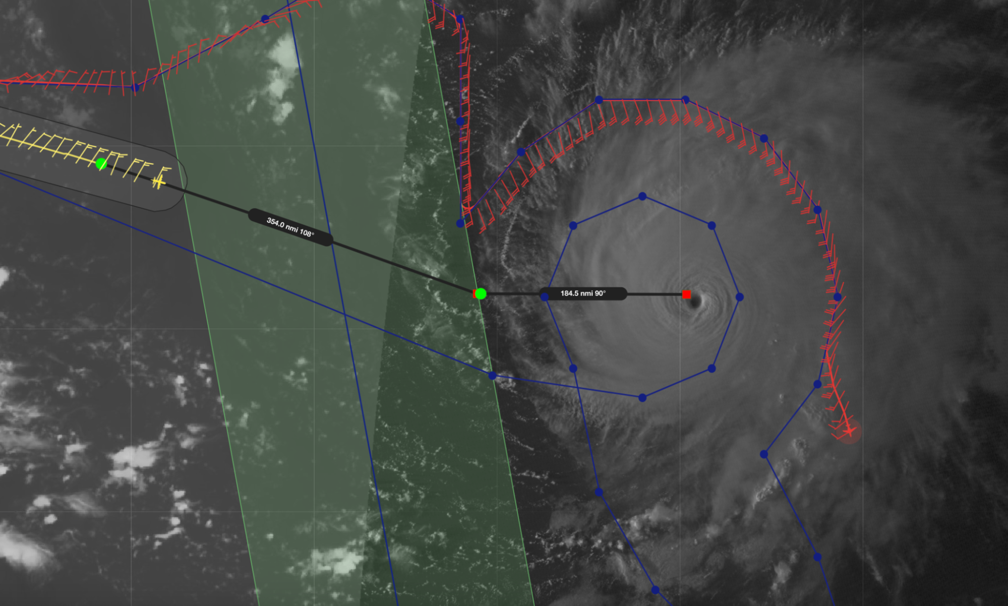
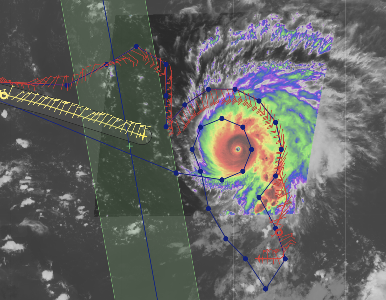
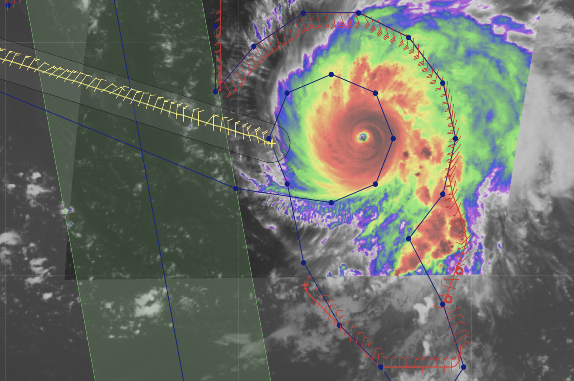
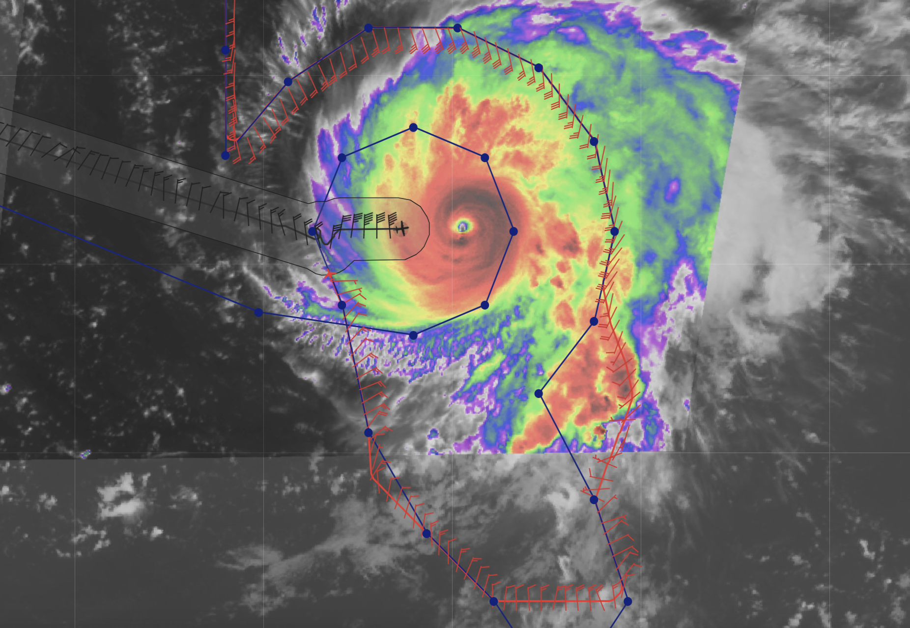
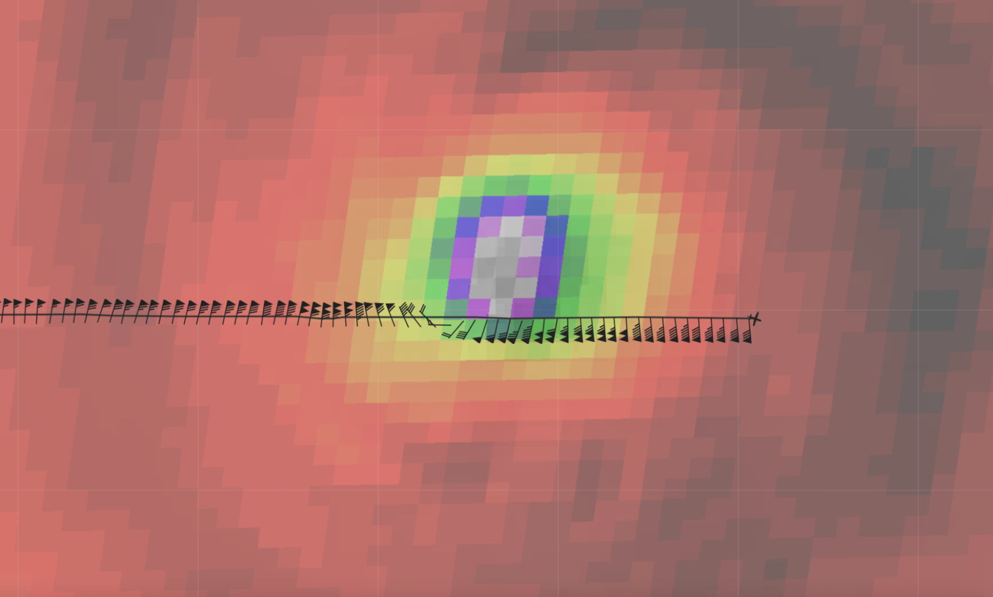
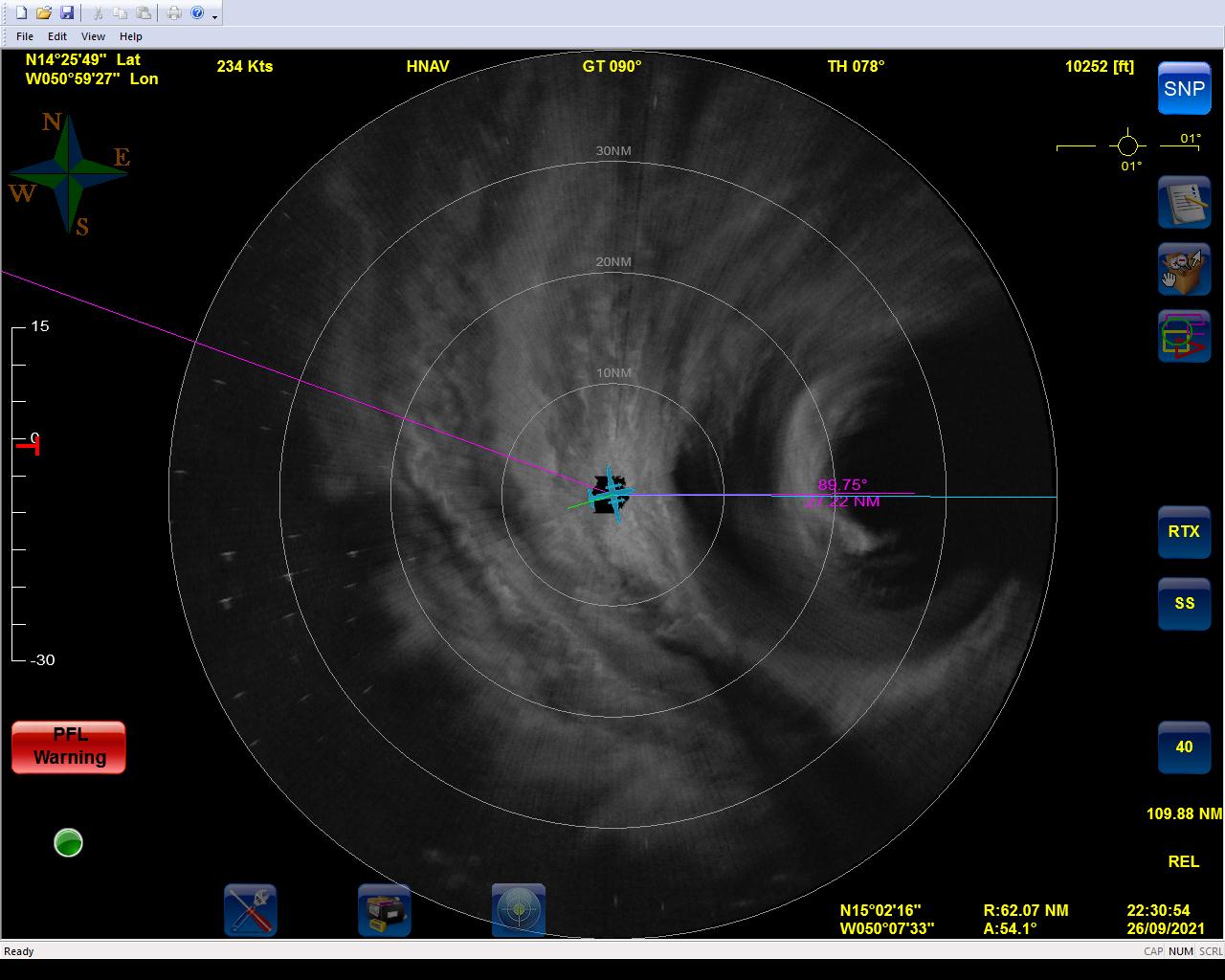
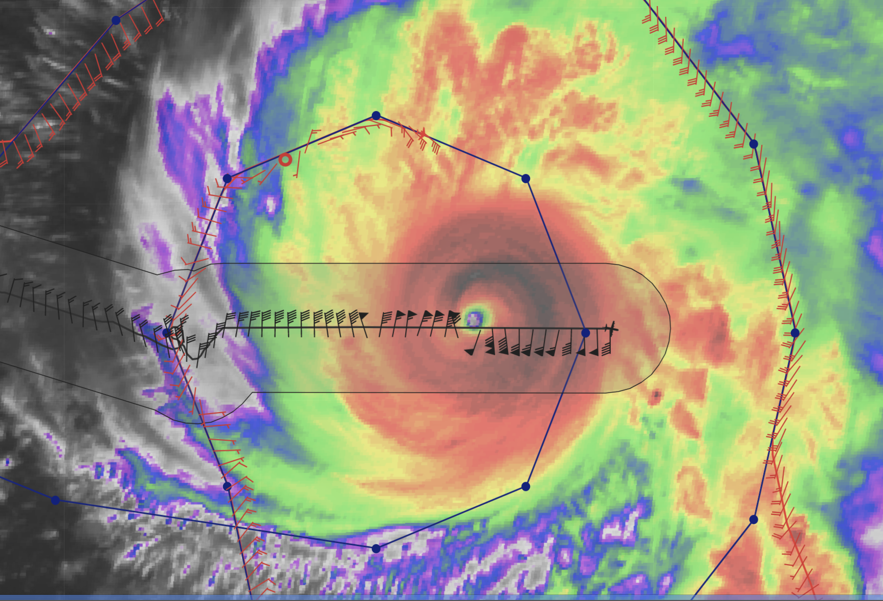
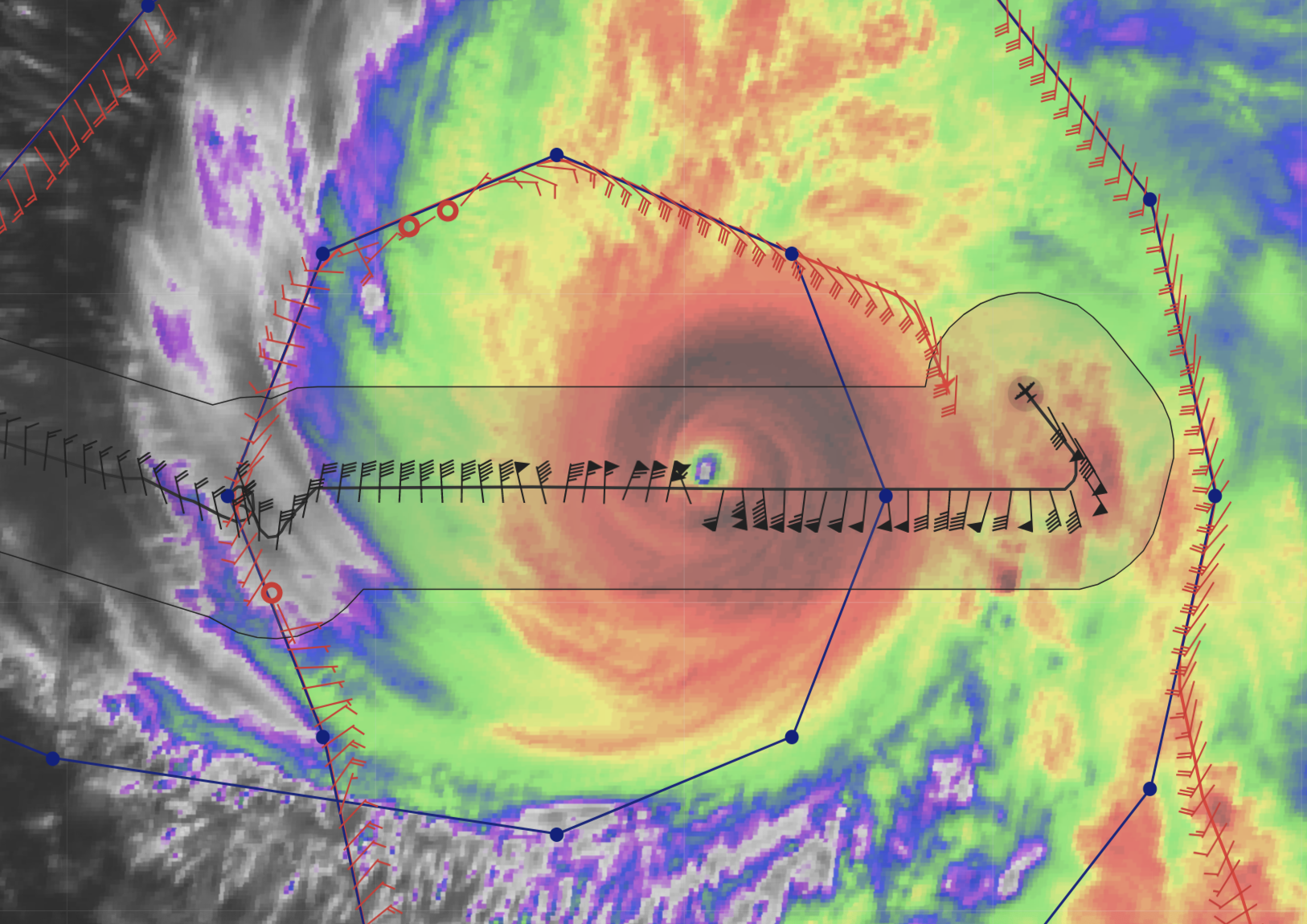
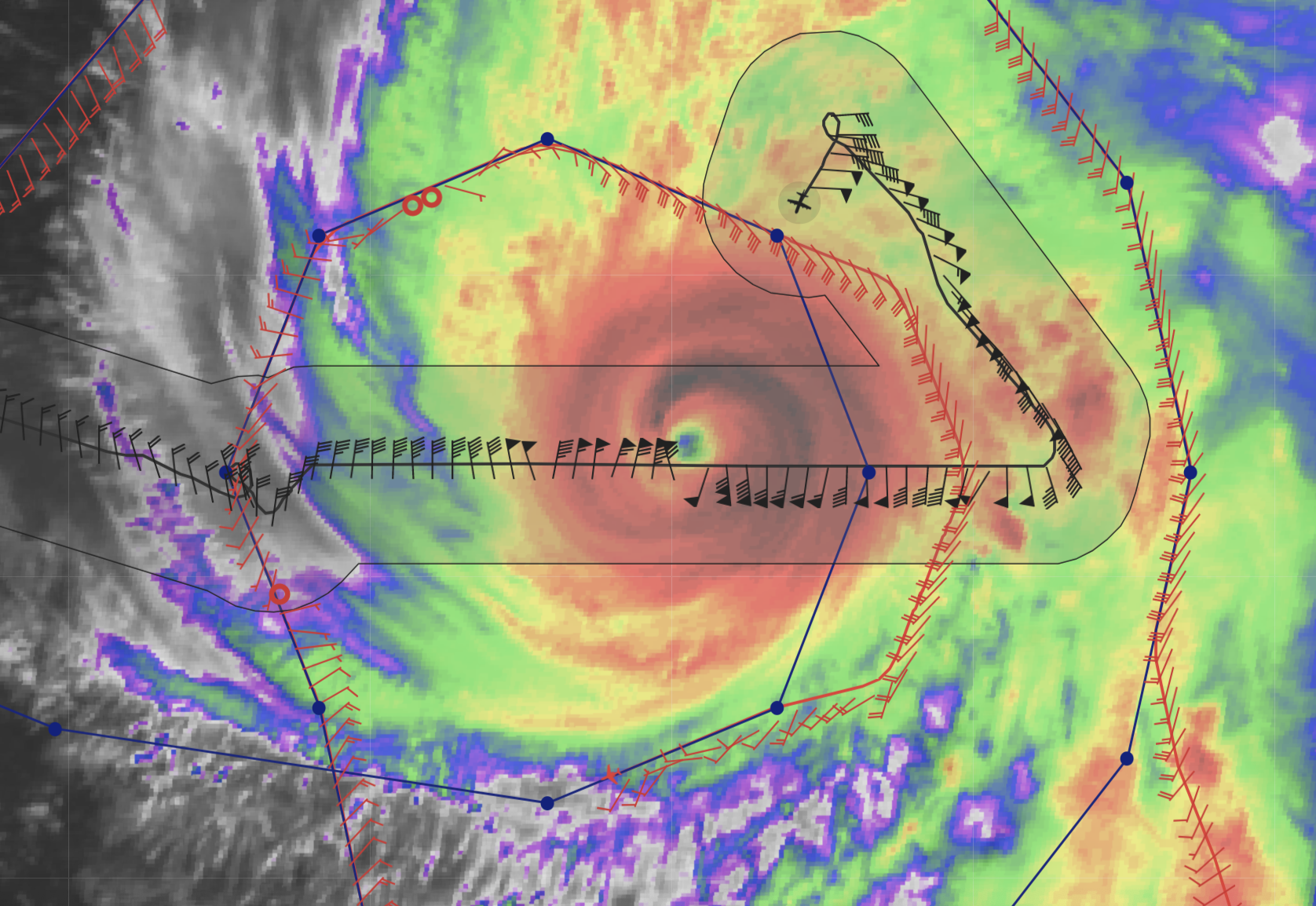
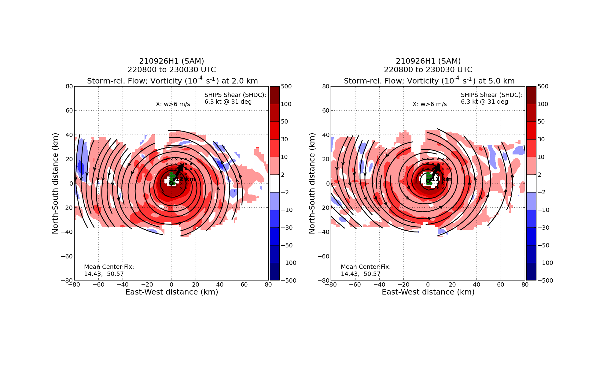
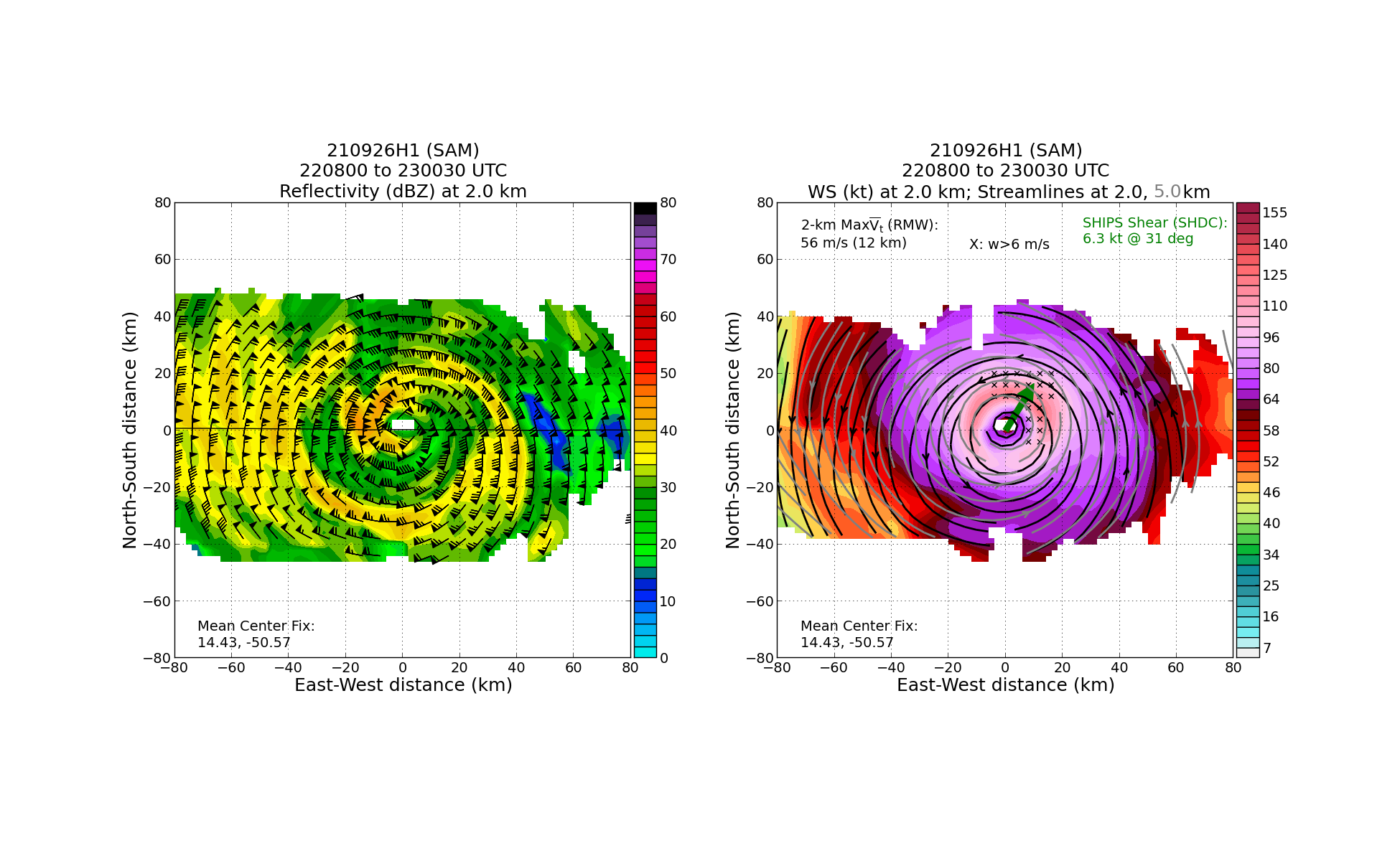


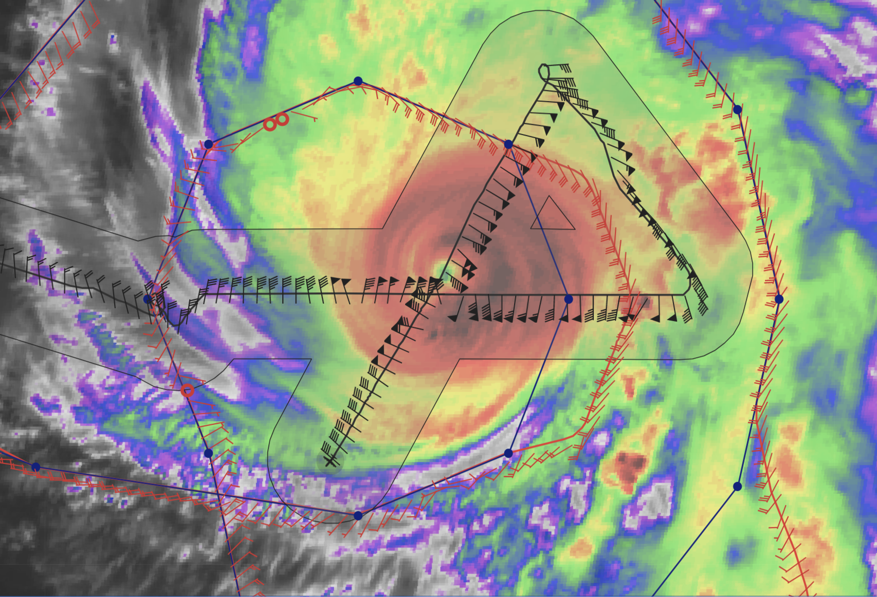
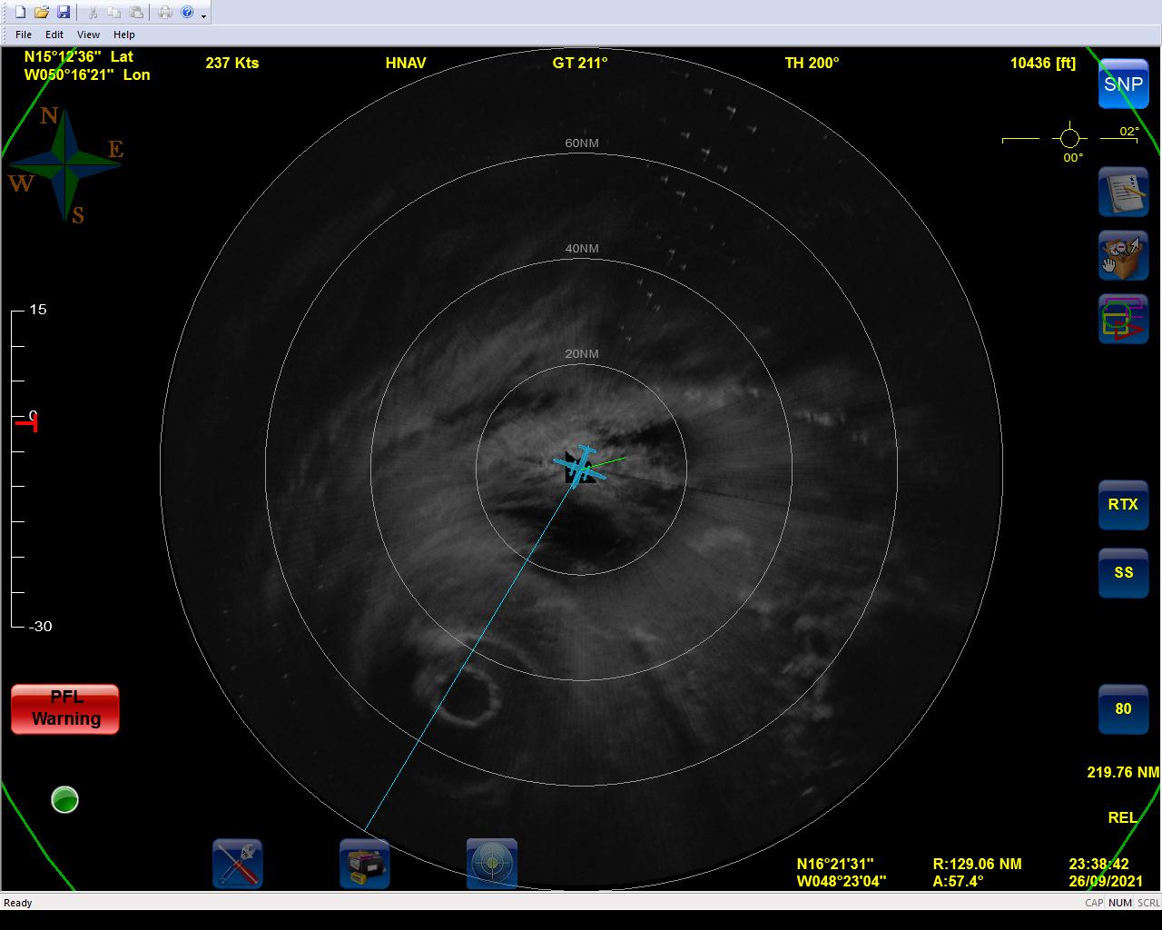
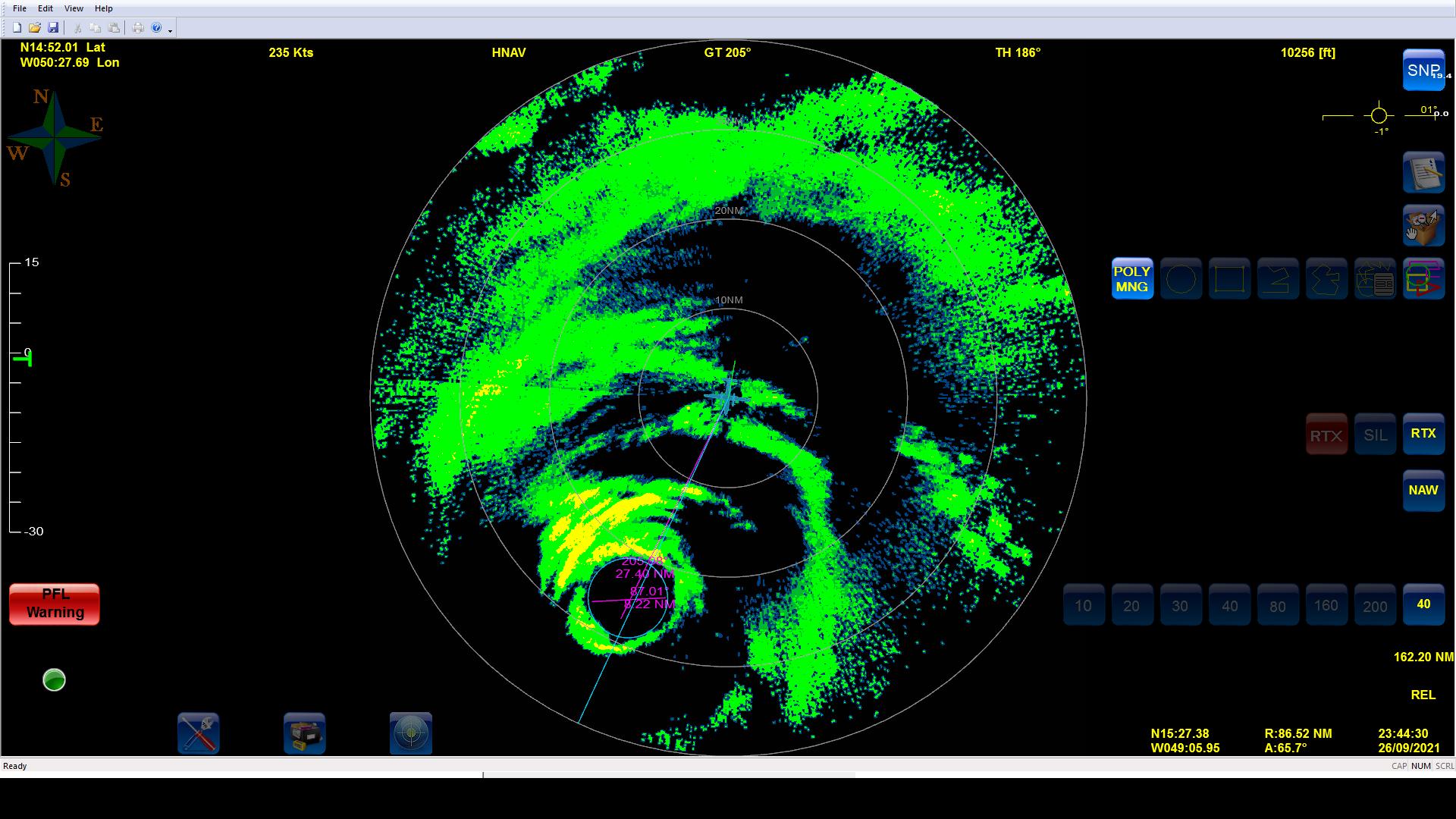


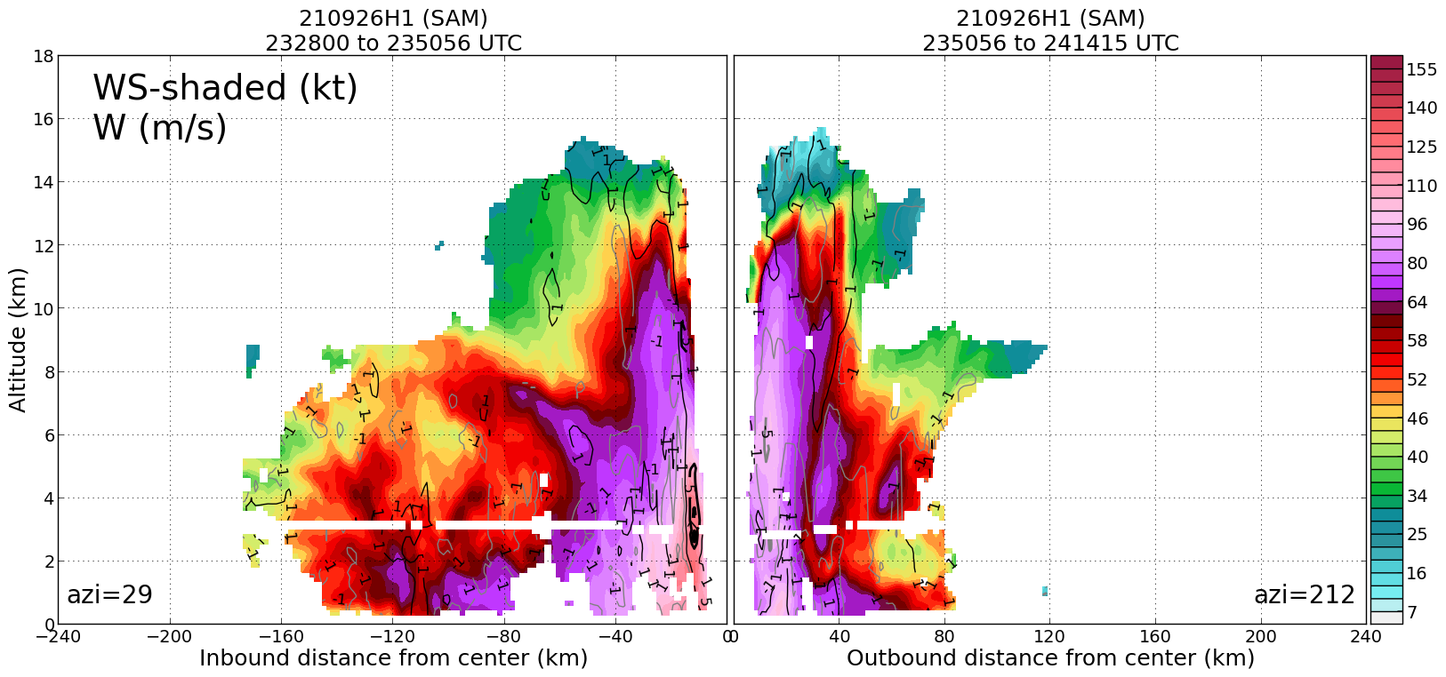
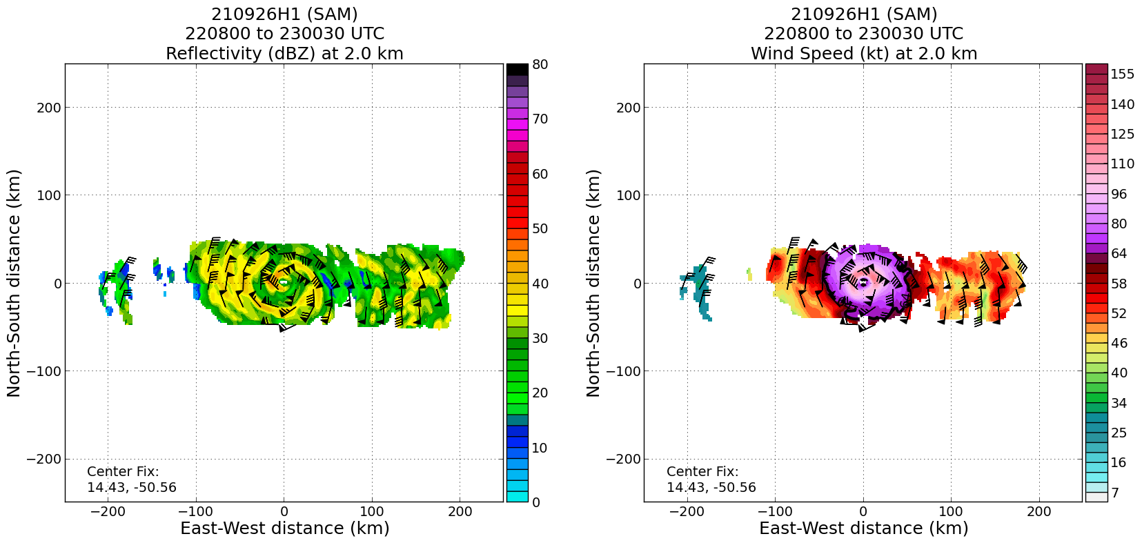
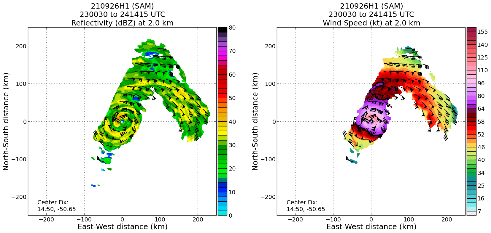


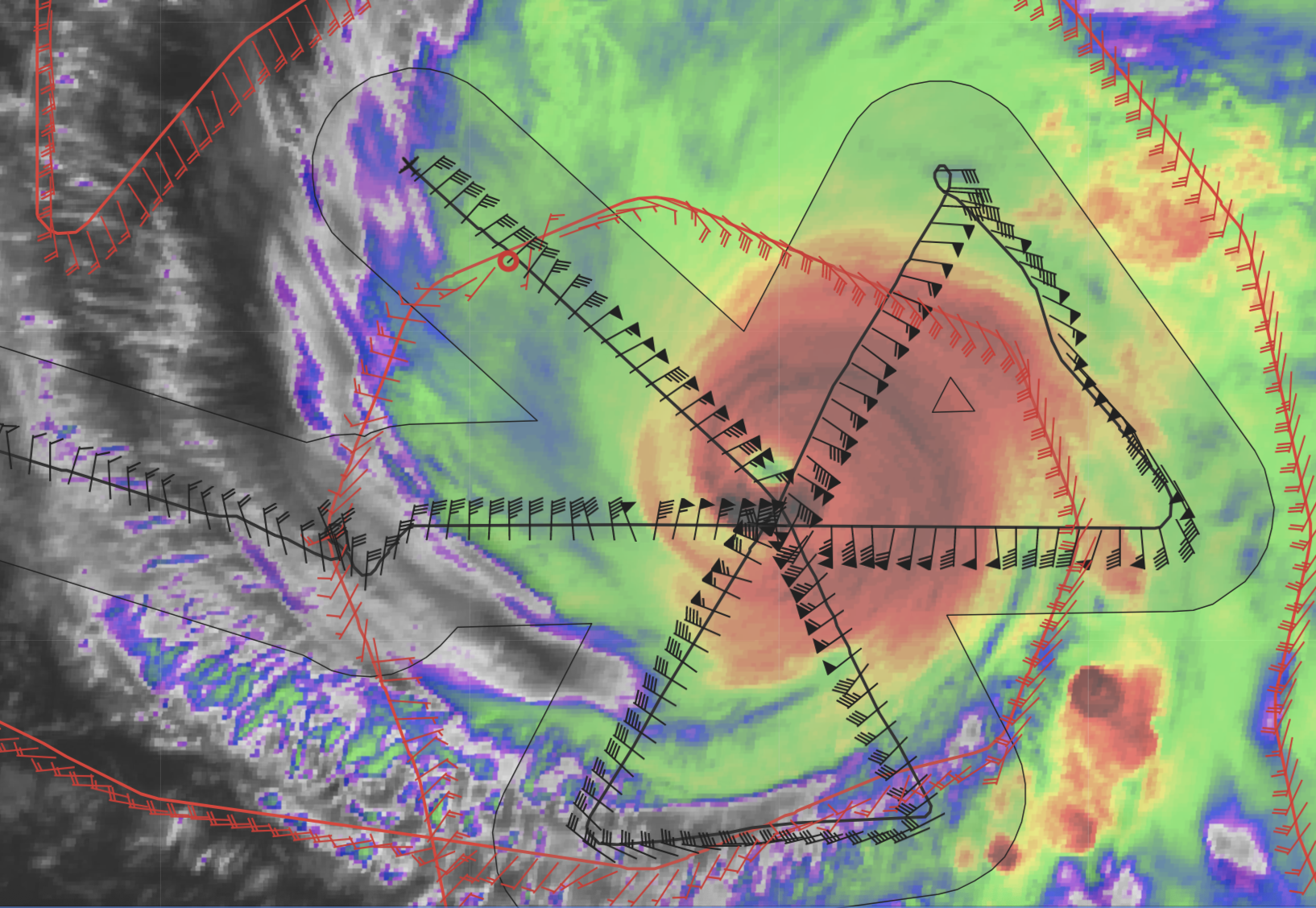
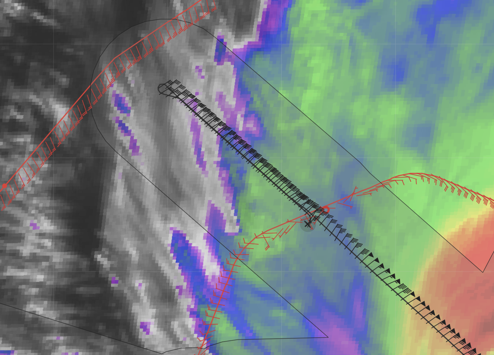

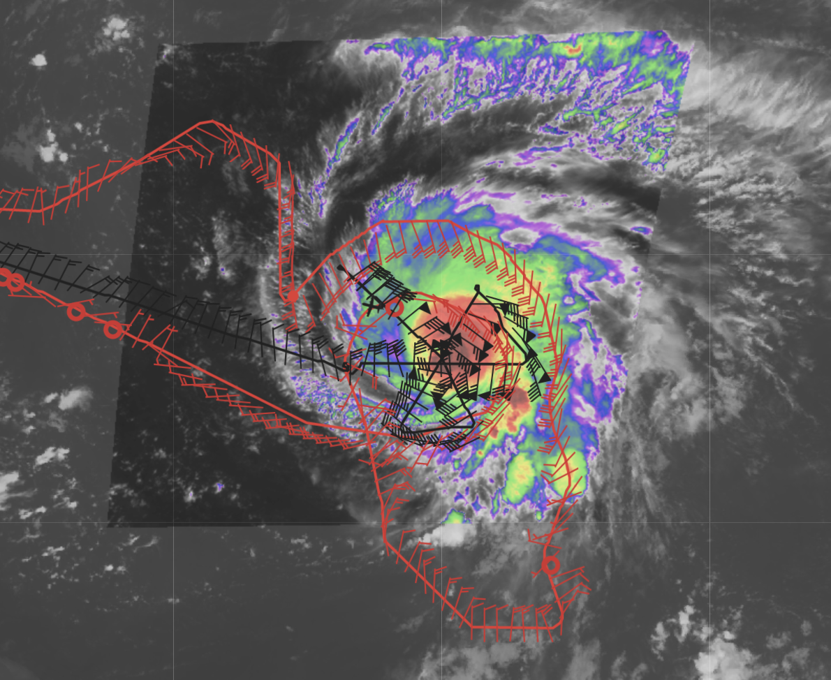
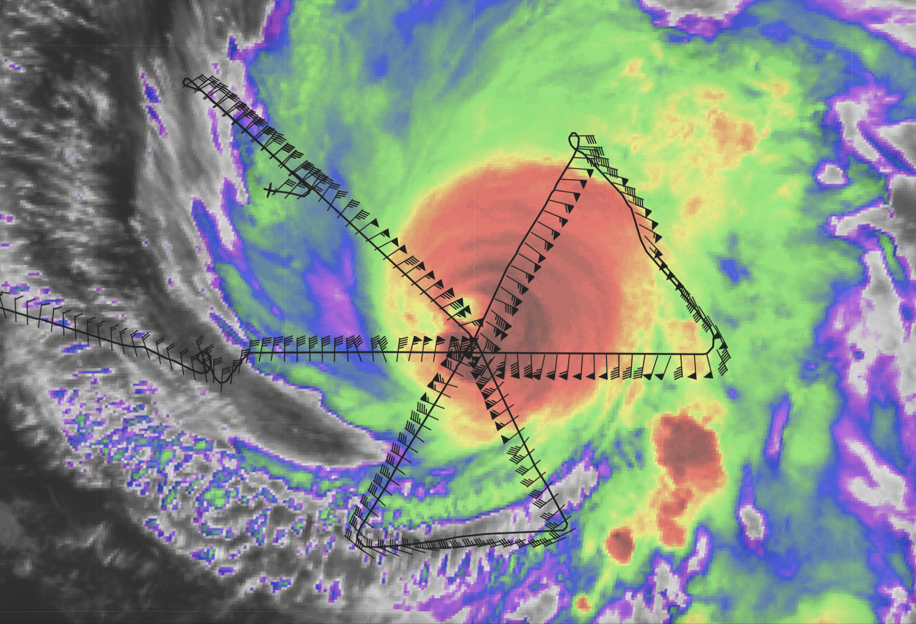

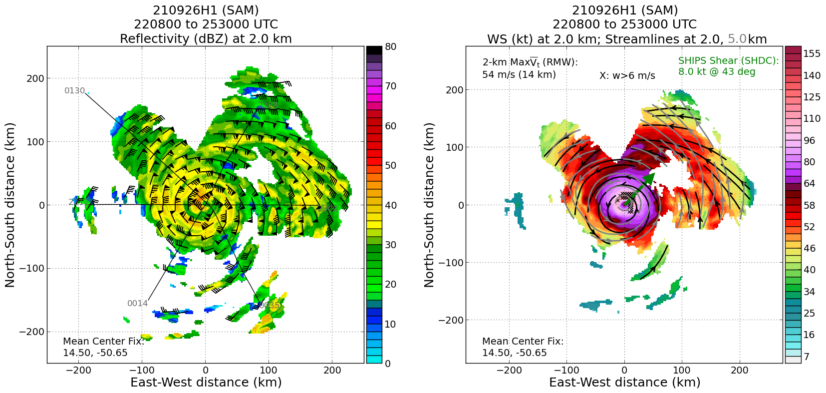
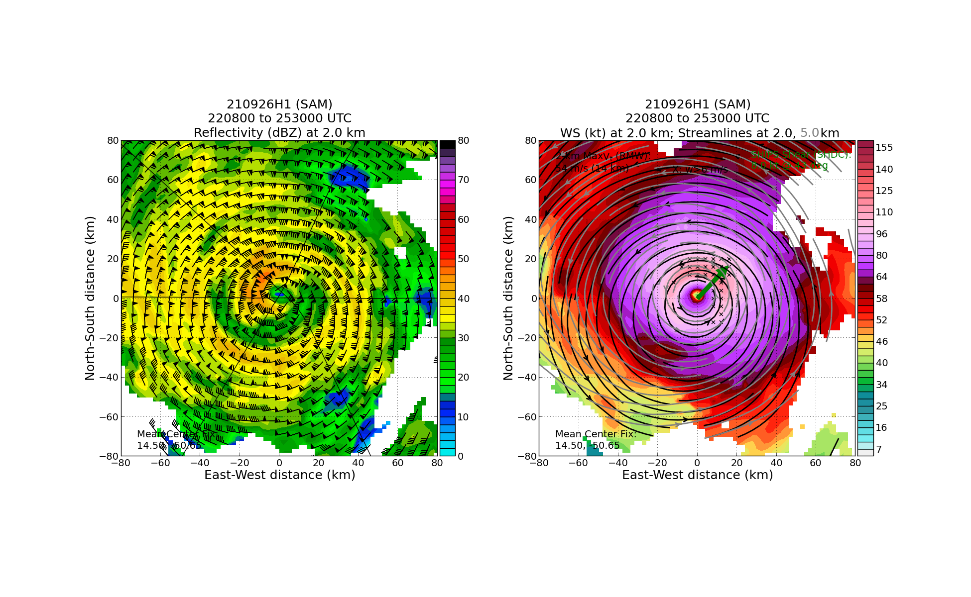
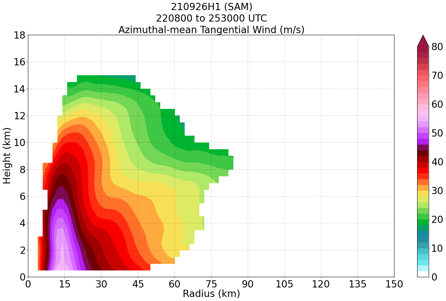

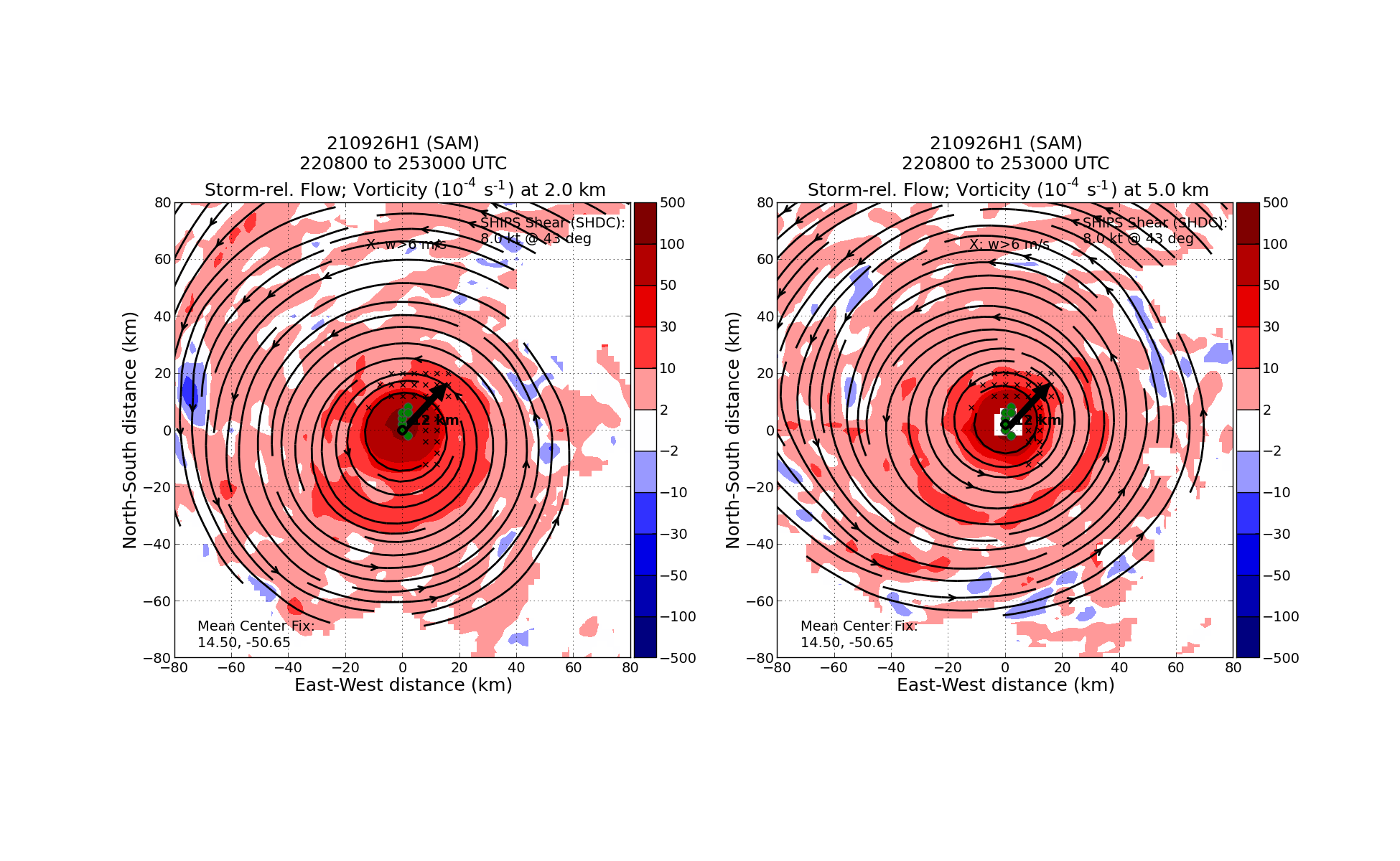
Post-Flight
| POST-FLIGHT 20210926H1 |
|
|
Mission Summary |
This mission captured secondary eyewall formation (SEF) as the storm was coming out of peak intensity (the 11 PM EDT NHC forecast discussion suggested an intensity of 135 kt, 929 mb based on the initial data from the first pass of the mission). The observations from the TDR, MMR, and flight level winds clearly indicated SEF formation at about 15-20 n mi from the center (though possibly already had started by the time the P-3 arrived in the storm). The storm is now on a weakening trend (perhaps as much as 14 mb increase in the central pressure, 943 mb by the end). The final satellite loops show the impact of the SEF and pending potential eyewall replacement cycle (ERC). There has been a dramatic warming of the inner central dense overcast (CDO) during the mission, especially on the western side of the inner core, and the eye that was so impressive earlier is filling in. By the second pass, one of the three planned RMW dropsonde releases were changed to be dropped near the radius of the SEF, which was of great interest to the ONR TCRI program, as well. One of the unique aspects of this flight versus other flights that have sampled SEFs is that the inner core was so small that the original eyewall and secondary eyewall were in range of the TDR on each pass; that will allow us to look in detail at the time evolution of the SEF process during the mission. So, overall, excellent data collection and now the question will be: does Sam complete an ERC? 34 dropsondes released (34 transmitted; 21 charged to NWS; 13 charged to ONR); 7 ONR AXBTs (all good; SSTs 27-28.5C)
|
|
Actual Standard Pattern Flown |
Butterfly with 90 n mi radial legs |
|
APHEX Experiments / Modules Flown |
Mature Experiment: Gravity Wave Module; flown in collaboration with ONR TCRI
|
|
Plain Language Summary |
|
|
Instrument Notes |
|
|
Final Mission Track |
P3 track
P3 + G-IV tracks
|
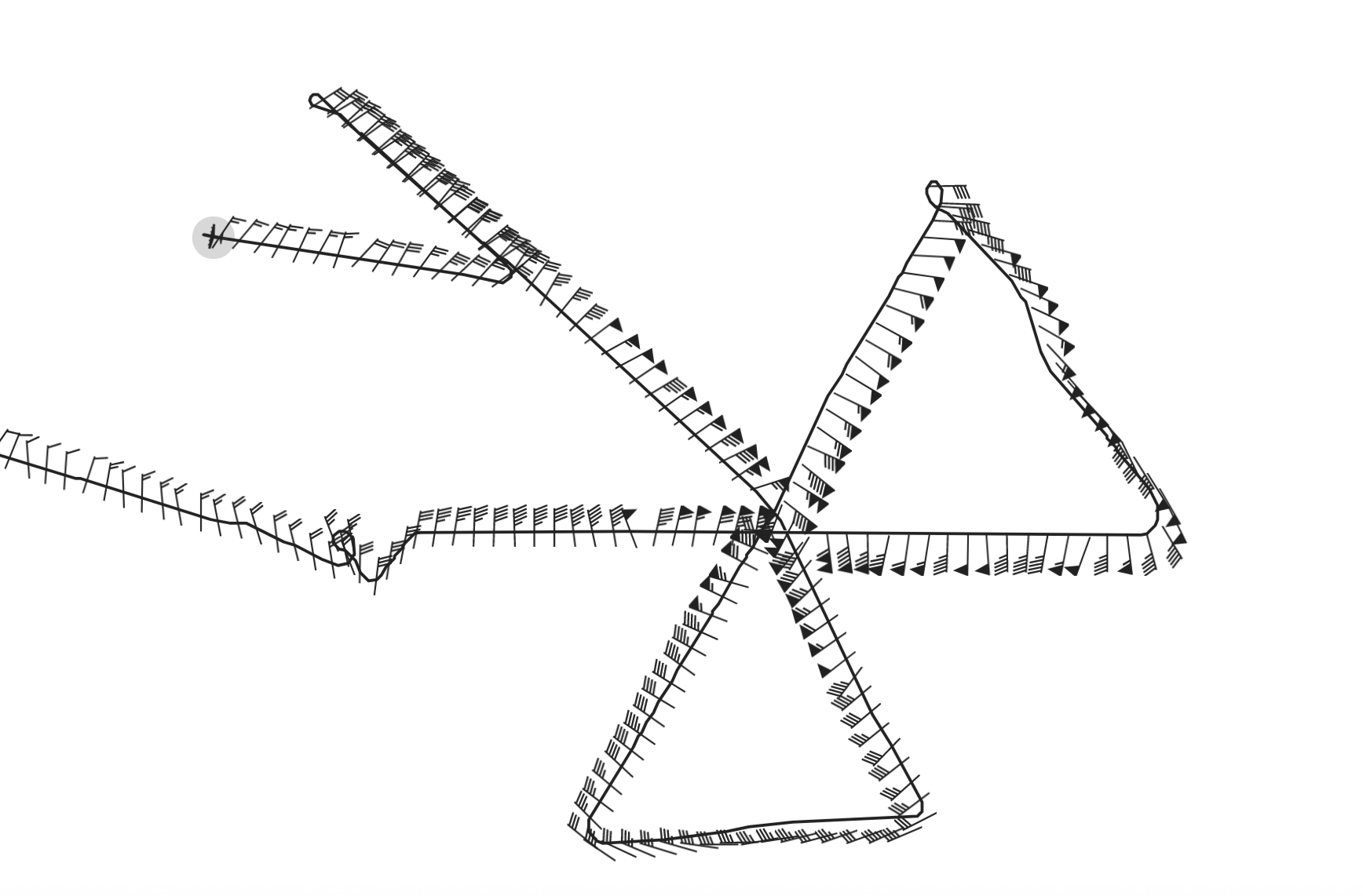

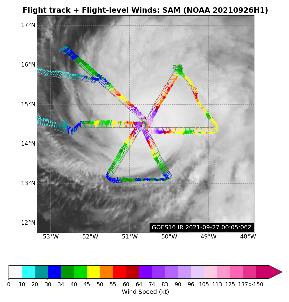
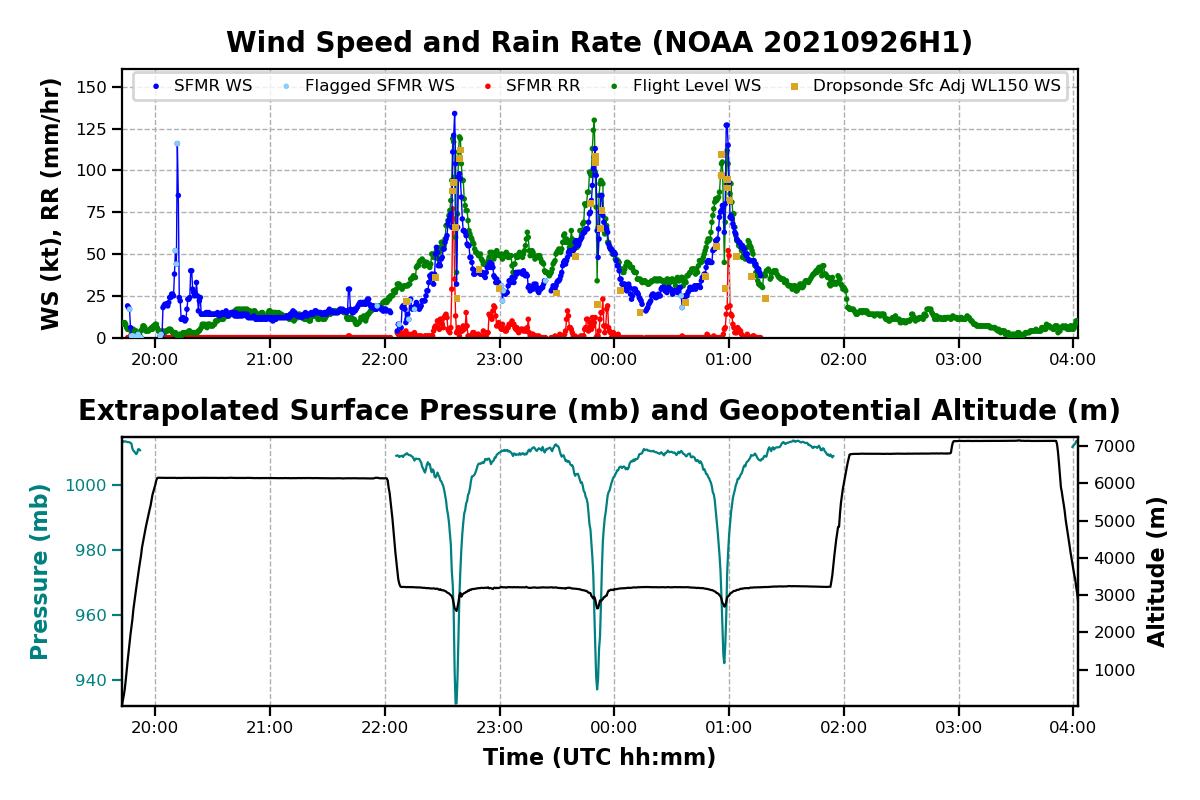
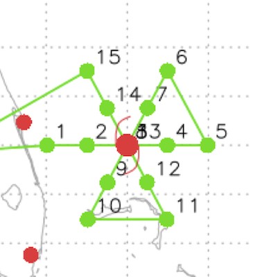
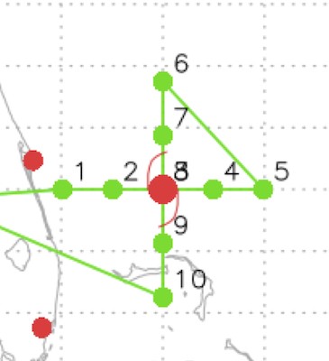
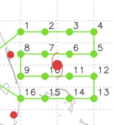
Mission Summary 20210926H1
|
Tasking ID |
0218A |
Aircraft |
NOAA42 |
|
Tasked by |
EMC/ONR/TCRI |
Planned pattern |
|
|
Takeoff time |
1942 Z |
Landing time |
0414 Z |
|
Takeoff Location |
St. Croix |
Landing Location |
St. Croix |
|
Flight Time |
8.1 hours |
Block Tine |
8.5 hours |
Expendables
| Real-time Radar Analyses: Total/Transmitted |
3/3 | Dropsondes: Total/Good/Transmitted |
34/34/34 |
|
Ocean Expendables |
None |
sUAS |
None |
Experiments & Modules
|
APHEX Experiments & Modules |
Data & Forms
Crew Lists
Science Crew
| Science Crew Manifest | |||
| Onboard | Ground | ||
|
Lead Scientist(s) |
Bucci |
Lead Scientist(s) |
Zawislak |
|
Radar Scientist(s) |
Bucci |
Radar Scientist(s) |
Gamache |
|
Sonde Scientist(s) |
J. Zhang |
Sonde Scientist(s) |
None |
|
NESDIS Scientist(s) |
None |
||
|
Guests (Affiliation) |
None |
||
Aircraft Crew
| Aircraft Crew Manifest | |
|
Pilot(s) |
Legidakes, Keith, Rannenberg |
|
Navigator(s) |
Hough, Utama |
|
Flight Engineer(s) |
Sanchez, Levine |
|
Flight Director(s) |
Hathaway, Lundry |
|
Data Technician(s) |
T. Richards |
|
AVAPS Tech(s) |
McAllister |
Flight Log
Pre-Flight
| PRE-FLIGHT 20210926H1 |
|
|
Flight Plan |
The planned pattern is for a 90 n mi butterfly with an additional Gravity Wave Module to the NW at the completion of the pattern. Altitude will be 10 kft.
|
|
Expendable Distribution |
Dropsondes to be released at the endpoints (EMC), midpoints (EMC), center (EMC), and RMWs on each inbound and outbound (6 charged to EMC, the remainder to ONR TCRI). ONR AXBTs will be released at each endpoint, and once in the center (if possible).
|
|
Preflight Weather Briefing |
As of the 11 AM EDT NHC Advisory, Hurricane Sam was located near 13.9N / 50.2W, had an estimated max wind of 125 kt, MSLP of 943 mb, and was moving west-northwest at 7 kt. Since yesterday, it appears that the storm has more or less been in a steady state, though the inner core continues to exhibit an impressive ring of deep convection and clear eye. The environment continues to be favorable for the storm to maintain its intensity, and perhaps strengthen some (though it is fairly close to its maximum potential intensity), though eyewall replacement cycles are certainly possible and could temporarily weaken the storm. It’ll be interesting to see whether this flight observes secondary eyewall formation.
|
|
Instrument Notes |
All instruments up and functioning. WSRA received a software update to potentially fix a bad data processing from yesterday’s flight. |
In-Flight
| IN-FLIGHT 20210926H1 |
|
|
Time [UTC] |
Event |
|
1941 |
Take off from STIX / 2 h until begin pattern |
|
2045 |
5 PM NHC Advisory: 14.2N / 50.5W, 130 kt, 938 mb, moving northwest at 6 kt: “Sam has found a way to strengthen some more today. The ring of intense convection surrounding the 15-n-mi-diameter eye has expanded in size over the past several hours, while cloud tops colder than -70C still completely surround the center. An earlier GMI microwave overpass revealed very strong eyewall convection tightly wrapped around the small eye, a feature oftentimes seen with intense hurricanes. The latest Dvorak intensity estimates from TAFB and SAB |
|
2053
|
Screenshot below shows the Aeolus track, which will pass by the storm around 2134 UTC. The P-3 will reach the 125 n mi eastern edge about 184 n mi from the center. G-IV has had to deviate around an outer band to target their sondes to the south of the storm.
|
|
2133 |
Aeolus just passed near the P-3 and just west of the storm.
|
|
2159 |
Pattern shifted a little east to center it on the eye (from SS mode on MMR)
|
|
2215 |
IP West (Sonde #1 [EMC1]; ONR AXBT #1). SST 28.4°C Sonde incorrectly processed. |
|
2225 |
G-IV now in the inner circumnav as the P-3 approaches the midpoint of the inbound from the west. Precipitation only extends to about that midpoint on the west side.
|
|
2226 |
MP West (Sonde #2 [EMC2]) |
|
2235 |
First RMW West (Sonde #3 [EMC3]) |
|
2235 |
Second RMW West (Sonde #4 [ONR1]) |
|
2236 |
Third RMW West (Sonde #5 [ONR2]) |
|
2237 |
Center #1 (Sonde #6 [EMC4]; ONR AXBT #2); 937 mb splash, 110deg./41 kt surface winds |
|
2238 |
First RMW East (Sonde #7 [EMC5]) |
|
2239 |
Second RMW East (Sonde #8 [ONR3]) |
|
2239 |
Third RMW East (Sonde #9 [ONR4]) |
|
2242 |
A look at the first pass of the center. MSLP was extrapolated to 932 mb, with 134 kt inbound (west side) maximum surface wind, though oddly the outbound to the east in the VDM only said 98 kt.
|
|
2249 |
MP E (Sonde #10 [EMC6]) |
|
2252 |
Looks like secondary eyewall formation is in progress based on MMR imagery! Interestingly the flight level wind speeds are symmetric on the east and west sides, but the surface winds were much higher on the west side than east. |
|
2259 |
EP E (Sonde #11 [EMC7]; ONR AXBT #3) |
|
2307 |
P-3 and G-IV passing next to each other — opportunity for TDR intercomparison. P-3 showing straiform on the MMR and TDR returns up to 10 km
|
|
2329 |
IP NE (Sonde #12 [EMC8]; ONR AXBT #4). Now inbound from the NE; G-IV on the southern portion of the inner circumnav.
|
|
2339 |
MP NE (Sonde #13 [EMC9]) |
|
2342 |
The first TDR analysis (below) shows an outer ring of vorticity at 2 and 5 km at 30 km from the center, suggesting that the SEF is forming. So we decided to drop the first RMW sonde on this inbound from the NE at 15 nmi (where the SEF may be) from the center, then keep the 2 RMW sondes. LPS is reporting an SEF feature on the MMR.
|
|
2347 |
SEF NE (Sonde #14 [ONR5]) |
|
2349 |
First RMW NE (Sonde #15 [EMC10]) |
|
2349 |
Second RMW NE (Sonde #16 [ONR6]) |
|
2351 |
Center #2 (Sonde #17 [EMC11]); 943 mb splash pressure and 155 deg./23 kt winds |
|
2352 |
First RMW SW (Sonde #18 [EMC12]) |
|
2353 |
Second RMW SW (Sonde #19 [ONR7]) |
|
2353 |
Third RMW SW (Sonde #20 [ONR8]) |
|
0003 |
MP SW (Sonde #21 [EMC13]) |
|
0012
|
G-IV has completed their inner circumnavigation and the P-3 is nearing the end of its first pass.
|
|
0013 |
EP SW (Sonde #22 [EMC14]; ONR AXBT #5) |
|
0027 |
MMR image from the inbound of the previous pass suggesting where the SEF could be. The eyewall is still well defined, but the SEF is showing up in almost all quadrants, even in the surface roughness mode.
|
|
0036 |
IP SE (Sonde #23 [EMC15]; ONR AXBT #6) |
|
0045 |
Inbound to the center on the last pass, from the southeast. Sondes on this pass will once again target the SEF location with one of the 3 RMW sondes (the other 2 will still be released in the RMW).
|
|
0047 |
MP SE (Sonde #24 [EMC16]) |
|
0051 |
A look at the 2nd TDR analyses showing continued SEF development. On the first pass, the low-level reflectivity was more of spiral outer eyewall structure; the 2nd pass shows more of an outer ring: The image below is the composite relative vorticity from the first two passes:
Then tangential wind profile from the 2nd pass:
The 1st pass at 2 km:
The 2nd pass at 2 km:
|
|
0053 |
SEF SE (Sonde #25 [ONR9]) |
|
0055 |
First RMW SE (Sonde #26 [EMC17]) |
|
0056 |
Second RMW SE (Sonde #27 [ONR10]) |
|
0057 |
Center #3 (Sonde #28 [EMC18]) |
|
0058 |
First RMW NW (Sonde #29 [ONR11]) |
|
0059 |
Second RMW NW (Sonde #30 [ONR12]) |
|
0059 |
Third RMW NW (Sonde #31 [EMC19]) |
|
0103 |
SEF NW (Sonde #32 [ONR13]) IR satellite loop shows warming cloud tops and trending towards weakening of the original inner eye.
|
|
0111 |
MP NW (Sonde #33 [EMC20]) |
|
0120 |
Nearing the completion of the butterfly; about time to do the Gravity Wave Module — looks nice and clear ahead to do the module.
|
|
0119 |
EP NW (Sonde #34 [EMC21]; ONR AXBT #7) |
|
0119 |
Start of Gravity Wave Module to the NW; nice and straight and level outbound, which is ideal for the GW module.
|
|
0133 |
Turning around for return leg of Gravity Wave Module |
|
0153 |
Gravity Wave Module completed very successfully.
|
|
|
Mission Complete. The final track:
|
|
|
|
|
|
The final satellite loops from the mission:
The third TDR analysis at 2 km showing how very little is left of the inner eyewall:
The final TDR composite analyses (keep in mind there is a lot of evolution in these structures being averaged together):
|
Post-Flight
| POST-FLIGHT 20210926H1 |
|
|
Mission Summary |
This mission captured secondary eyewall formation (SEF) as the storm was coming out of peak intensity (the 11 PM EDT NHC forecast discussion suggested an intensity of 135 kt, 929 mb based on the initial data from the first pass of the mission). The observations from the TDR, MMR, and flight level winds clearly indicated SEF formation at about 15-20 n mi from the center (though possibly already had started by the time the P-3 arrived in the storm). The storm is now on a weakening trend (perhaps as much as 14 mb increase in the central pressure, 943 mb by the end). The final satellite loops show the impact of the SEF and pending potential eyewall replacement cycle (ERC). There has been a dramatic warming of the inner central dense overcast (CDO) during the mission, especially on the western side of the inner core, and the eye that was so impressive earlier is filling in. By the second pass, one of the three planned RMW dropsonde releases were changed to be dropped near the radius of the SEF, which was of great interest to the ONR TCRI program, as well. One of the unique aspects of this flight versus other flights that have sampled SEFs is that the inner core was so small that the original eyewall and secondary eyewall were in range of the TDR on each pass; that will allow us to look in detail at the time evolution of the SEF process during the mission. So, overall, excellent data collection and now the question will be: does Sam complete an ERC? 34 dropsondes released (34 transmitted; 21 charged to NWS; 13 charged to ONR); 7 ONR AXBTs (all good; SSTs 27-28.5C)
|
|
Actual Standard Pattern Flown |
Butterfly with 90 n mi radial legs |
|
APHEX Experiments / Modules Flown |
Mature Experiment: Gravity Wave Module; flown in collaboration with ONR TCRI
|
|
Plain Language Summary |
|
|
Instrument Notes |
|
|
Final Mission Track |
P3 track
P3 + G-IV tracks
|
Mission Summary 20210927I1
|
Tasking ID |
0318A |
Aircraft |
NOAA43 |
|
Tasked by |
EMC |
Planned pattern |
|
|
Takeoff time |
1138 Z |
Landing time |
1812 Z |
|
Takeoff Location |
St. Croix |
Landing Location |
St. Croix |
|
Flight Time |
6.6 hours |
Block Tine |
6.7 hours |
Expendables
| Real-time Radar Analyses: Total/Transmitted |
2/2 | Dropsondes: Total/Good/Transmitted |
19/17/17 |
|
Ocean Expendables |
5 ONR AXBT |
sUAS |
None |
Experiments & Modules
|
APHEX Experiments & Modules |
|
Data & Forms
Crew Lists
Science Crew
| Science Crew Manifest | |||
| Onboard | Ground | ||
|
Lead Scientist(s) |
Holbach |
Lead Scientist(s) |
Hazelton |
|
Radar Scientist(s) |
Holbach |
Radar Scientist(s) |
Fischer |
|
Sonde Scientist(s) |
Alaka |
Sonde Scientist(s) |
None |
|
NESDIS Scientist(s) |
Chang, Jelanak, Sapp |
||
|
Guests (Affiliation) |
None |
||
Aircraft Crew
| Aircraft Crew Manifest | |
|
Pilot(s) |
Didier, Doremus, Copare |
|
Navigator(s) |
Freeman |
|
Flight Engineer(s) |
Darby, Stokes |
|
Flight Director(s) |
Holmes |
|
Data Technician(s) |
Mascaro |
|
AVAPS Tech(s) |
Warnecke |
Flight Log
Mission Summary 20210927H1
|
Tasking ID |
WA09A |
Aircraft |
NOAA42 |
|
Tasked by |
HRD/ONR TCRI |
Planned pattern |
|
|
Takeoff time |
1955 Z |
Landing time |
0413 Z |
|
Takeoff Location |
Lakeland |
Landing Location |
Lakeland |
|
Flight Time |
8.3 hours |
Block Tine |
8.6 hours |
Expendables
| Real-time Radar Analyses: Total/Transmitted |
4/4 | Dropsondes: Total/Good/Transmitted |
25/25/25 |
|
Ocean Expendables |
5 ONR AXBT |
sUAS |
0 |
Experiments & Modules
|
APHEX Experiments & Modules |
Early Stage Experiments: |
Data & Forms
Crew Lists
Science Crew
| Science Crew Manifest | |||
| Onboard | Ground | ||
|
Lead Scientist(s) |
Rogers |
Lead Scientist(s) |
Holbach |
|
Radar Scientist(s) |
Rogers |
Radar Scientist(s) |
Gamache/Alvey |
|
Sonde Scientist(s) |
J. Zhang |
Sonde Scientist(s) |
None |
|
NESDIS Scientist(s) |
None |
||
|
Guests (Affiliation) |
None |
||
Aircraft Crew
| Aircraft Crew Manifest | |
|
Pilot(s) |
Rossi, Shaw, Keith |
|
Navigator(s) |
Utama |
|
Flight Engineer(s) |
Sanchez, Stokes |
|
Flight Director(s) |
Hathaway, Lundry |
|
Data Technician(s) |
Todd Richards |
|
AVAPS Tech(s) |
McAlister |
Flight Log
Pre-Flight
| PRE-FLIGHT 20210925H1 |
|
| Flight Plan | This is an HRD-tasked research mission into Hurricane Ida in collaboration with ONR/TCRI. The planned flight track calls for flying a rotated figure-4 with possible additions of a microphysical spiral module in stratiform precipitation between points 2 and 3 along with a convective burst module. |
| Expendable Distribution | Endpoint, midpoint, eyewall/RMW drops, center drops. AXBTs planned at points 1, 3, 6, and 7 along with one center pass as shown above. |
| Preflight Weather Briefing | Ida has strengthened into a hurricane through the day as it approaches the western tip of Cuba. As of the 1900 UTC advisory, NHC has Ida at 65 kt with a minimum central pressure of 987 mb and moving NW at 13 kt. Ida is currently passing over the Isle of Youth and will be approaching the southern coast of the Cuban mainland near the time that the P-3 is reaching the storm.
The NHC forecast calls for Ida to maintain hurricane strength as it passes over Cuba and potentially rapidly intensify over the Gulf of America before making landfall along the northern Gulf coast. |
| Instrument Notes | None |
In-Flight
| IN-FLIGHT 20210925H1 |
|
|
Time [UTC] |
Event |
| 1955 | Takeoff from Lakeland |
| 2030 | Interesting evolution in the cloud structure on IR as Ida’s central dense overcast (CDO) approached the northern edge of Cuba. It appears to go from a well organized CDO to being very ragged on the northern half of the storm. Curious if the mountains along the northern coast of Cuba disrupted the circulation enough to cause this collapse. |
| 2103 | Discussing possible targets for microphysics spiral. There is a potential that stratiform precip is present on the SE side (outbound leg 1) that could be a target. Another option is between pts 2 and 3, likely on the N side of Cuba. Plan is to assess on the outbound pass to determine if it’s worth backtracking for the spiral near the center on the SE side. |
| 2106 | Arrived at initial point (IP) |
| 2114 | Rob noted stratiform precip present on TDR off their left wing |
| 2122 | Slight deviation around convection |
| 2124 | Jun noted RMW sonde hasd 66 kt surface wind |
| 2130 | Rob noted that they broke out into the clear with a stratus deck below and above them. This coincides with them exiting the region of coldest cloud tops. |
| 2133 | TDR Xchat channel reported antenna packet communication dead. |
| 2136 | No RMW or 50 km drops since they would have been over land |
| 2137 | Todd is rebooting the TDR |
| 2139 | TDR back up |
| 2140 | 2-min HRD center: 22.41N, 83.85W (6.66 nmi SE of marked center). Lowest extrap pressure of 988 mb and min wind speed 14.641 kt. |
| 2158 | EP leg 1 (pt 2). Turning back inbound to target the region of stratiform precip for the microphysics spiral. |
| 2159 | John had Rob close the loop_check_sweeps window to see if that was causing a backlog that was disrupting the xchat/comms with the radar workstations ability to sync files. |
| 2217 | Beginning microphysics spiral in region east of the center |
| 2232 | Top of the microphysics spiral at 22 kft. Rob noted that there wasn’t much precip at the higher altitudes. We had discussions about doing a second microphysics spiral to the NW of this location, but decided to proceed to pt3 to allow for more options as the flight progresses and to get the second pass in and hopefully catch a convective burst (CB) as it comes offshore on the W side of the eye. |
| 2249 | Finished descending back to 10 kft and proceeding to pt 3 |
| 2301 | Some lightning showing up in the CB that has been occurring to the W of the eye. It’s definitely bursting! |
| 2310 | Inbound at pt 3 |
| 2316 | Tracking slightly right of planned track on leg 2 due to Havana air space |
| 2328 | No RMW, quarter pt, or center due to land on this inbound leg |
| 2335 | Rob noted a closed eyewall, almost on MMR. Kind of a banded structure. |
| 2337 | Marked center. 2-min HRD center: 22.48N 83.41W. 5.74 n mi NW of marked center. Lowest extrap pressure: 987 mb minimum wind speed: 11.687 kt No RMW drop outbound as they were still over land |
| 2343 | Rob noted the flight level winds were very asymmetric on this pass. About a 25-30 kt difference between NE and SW |
| 2347 | We will not be able to drop a BT in the center, so we are trying to decide where we want to drop the 5th BT. Rob’s suggestion was midpoint outbound to the N. Jun thought that was a good plan |
| 2349 | Rob said we will have about 20 mins for a CB module. Trying to determine potential targets. Discussion about the south side of the eyewall. Cold cloud tops on IR imagery have expanded quite a bit so it’s hard to tell from the ground where a good CB target would be anymore. Will have to rely on MMR on this pass to see if there is anything to target. |
| 2359 | Rob talked to Nikki and they were wondering if we could fly parallel to the CB in the SW eyewall inside the eye. The legs would be pretty short ~8-10 n mi. John G. said that you probably want at least ~30 n mi to get enough overlap between the fore and aft beams. You need 2 mins on each side of the length that you want. |
| 0006 | End of leg 2, pt 4 |
| 0009 | Rob is thinking about doing radial pennies, 30 n mi in length on the N side outbound. So, go out initially 30 n mi from the start of the leg, turn around and come back 30 n mi and then resume outbound and the remainder of the pattern. Right now there isn’t much showing on Cuba radar or IR imagery to indicate a good target on the N side. |
| 0020 | Pt 5, begin leg 3 |
| 0033 | Midpoint sonde |
| 0034 | Approaching southern eyewall |
| 0036 | Rob noted that there is nothing showing up on this inbound leg in terms of convection. Just a thin line of returns on the nose, broken on the MMR. Stratiform east of them over Cuba. Seeing some more on the east side further north. |
| 0040 | Latest frame of Cuba radar looks like there might be something bursting on the N side. |
| 0042 | Rob noted a feature showing up on the MMR ~40 n mi N of them, which is the distance I was noting as well for the feature on Cuban radar. Rob noted another feature ~30 n mi NNE of their position. The feature to their N looks like a better target for a CB module. Can also do drops on that one since it is farther offshore. |
| 0045 | The CB on the N side looks like it might be trying to wrap into the eyewall. |
| 0046 | Mark center |
| 0050 | Turning to 315 degree heading to start the CB module on the N side of the eye just off the N shore of Cuba. Will go for 30 n mi outbound then back, then resume pattern |
| 0052 | Rob noted that this feature is pretty narrow. He said it does look like it might be trying to wrap into the eyewall, but it’s kind of localized on the MMR right now. They are seeing red on the nose radar. |
| 0054 | Rob noted echo tops ~8-12 km, so moderately deep convection. |
| 0055 | Some echo tops up to 14-15 km now. |
| 0057 | Rob is wondering if we should do a third pass back out through this feature on the same radial then resume pattern. |
| 0059 | Turning back inbound for a second pass through CB. |
| 0100 | Climbing to 12 kft because AF is entering the storm |
| 0101 | Trying to decide if it’s better to get TDR coverage back on the S-N radial or more beneficial to get the 3rd pass through the CB. Cold cloud tops are starting to show up in IR imagery near this CB that we are targeting. Rob thinks the CB is growing, so we decided that since this was a research mission it would be more beneficial to do the 3rd pass through the CB. |
| 0104 | Rob noted that the CB looks more impressive on nose radar |
| 0105 | Having some comms dropouts |
| 0110 | Turned back outbound to 315 degree heading for 3rd pass through CB. |
| 0114 | Just noticed HDOBs are delayed coming off the plane. Last message on the ground is from 2314Z. TDR is also not coming off plane |
| 0119 | End of 3rd pass through CB |
| 0125 | Paralleling the CB somewhat while heading to pt 6 |
| 0129 | Midpoint sonde, combo drop |
| 0130 | GOES-16 IR imagery showing cold cloud tops developing in region of CB sampling |
| 0132 | Rob checked the WMM app and said there are a lot of messages pending being sent off the plane, so it seems like comms are just being very slow |
| 0133 | Todd made a change to a config file and messages should be coming off now. |
| 0140 | Turning downwind at pt 6 |
| 0142 | Turning right a little for avoidance |
| 0212 | Turning inbound at pt 7 |
| 0224 | HDOBs appear to have caught up arriving on the ground |
| 0234 | They are approaching the CB that they flew earlier. Rob said they have the surface roughness mode on right now, but it doesn’t look that threatening on the nose radar. Just yellows. The tail looks mostly stratiform. Cuba radar was indicating it may have become stratiform, but we weren’t sure if that was just because of it being at the edge of the radar range. |
| 0237 | TDR data trickling off slowly. John G. said we will probably only get TDR data from two passes off the plane. |
| 0238 | Rob noted expansive echos up to 15 km on TDR to their right. |
| 0239 | Winds are sending them south. They are doing some “light” hunting. Rob noted this storm has been difficult to fix the whole flight. |
| 0241 | Rob said that the MMR surface roughness is really interesting. Almost two centers, one behind and one in front of them. Seems like a new eye might be trying to form. MMR shows interesting structure. |
| 0248 | Rob said the MMR looks more reasonable now, like they’re in the center just barely offshore |
| 0251 | Rob notes that that it’s almost like it’s getting better organized as it emerges offshore |
| 0253 | RMW sonde on the E side |
| 0259 | Just noticed that after they climbed to 12 kft, the SFMR was being /// in the HDOBs. The altitude threshold has not been removed and they were exceeding the 12.5 kft radar altitude threshold. After chatting with Ashley, we will try to go to 8 kft when necessary rather than 12 kft on future flights into Ida. |
| 0309 | Endpoint, pt 8. Heading back to LAL |
| 0341 | TDR turned off |
Post-Flight
| POST-FLIGHT 20210925H1 |
|
| Mission Summary | We successfully flew a rotated figure-4 pattern along with a microphysics spiral module on the east side of the storm south of Cuba and a convective burst module during the third leg on the N side of Cuba. Throughout the flight, we sampled the storm before making landfall on the south coast of Cuba, while it was over Cuba, and after it emerged off the north coast of Cuba. The evolution of the structure throughout this flight was quite interesting as the interactions with Cuba seemed to disrupt the low level circulation, but the convection and upper levels seemed to be maintained well enough that it did not hinder the storm’s evolution significantly. The 0300 UTC NHC advisory had Ida at a minimum SLP of 989 mb and max sustained winds of 70 kts.
IR imagery throughout the flight showed the CDO collapse on the north side as Ida approached Cuba and began to redevelop as it crossed over Cuba. Another interesting observation is that in all of the TDR analyses, the strongest inflow was depicted as occurring on the north side of the circulation. However, I wonder if this could be an artifact of land in the TDR data. Final plot of HDOBs: Expendables deployed: 25 dropsondes (10 HRD, 15 ONR); 5 NRL AXBTs |
| Actual Standard Pattern Flown | Rotated Figure-4 |
| APHEX Experiments / Modules Flown | Early Stage Experiment: AIPEX; Early Stage Experiment: Convective Burst Structure and Evolution Module; Early Stage Experiment: Stratiform Spiral Module; was flown in collaboration with ONR TCRI |
| Plain Language Summary |
|
| Instrument Notes | Several issues with data transmission, especially during the second half of the flight. We also had problems with the TDR radarsync throughout the flight. |
| Final Mission Track | |
Mission Summary 20210929H1
|
Tasking ID |
WC09A |
Aircraft |
NOAA42 |
|
Tasked by |
HRD |
Planned pattern |
|
|
Takeoff time |
1703 Z |
Landing time |
2320 Z |
|
Takeoff Location |
Lakeland |
Landing Location |
Lakeland |
|
Flight Time |
6.3 hours |
Block Tine |
6.6 hours |
Expendables
| Real-time Radar Analyses: Total/Transmitted |
3/3 | Dropsondes: Total/Good/Transmitted |
18/18/18 |
|
Ocean Expendables |
7 UM AXBT |
sUAS |
0 |
Experiments & Modules
|
APHEX Experiments & Modules |
End Stage Experiments:
Mature Stage Experiments: Ocean Observing: |
Data & Forms
Crew Lists
Science Crew
| Science Crew Manifest | |||
| Onboard | Ground | ||
|
Lead Scientist(s) |
Rogers |
Lead Scientist(s) |
Holbach |
|
Radar Scientist(s) |
Rogers |
Radar Scientist(s) |
Gamache |
|
Sonde Scientist(s) |
Jun Zhang |
Sonde Scientist(s) |
None |
|
NESDIS Scientist(s) |
None |
||
|
Guests (Affiliation) |
None |
||
Aircraft Crew
| Aircraft Crew Manifest | |
|
Pilot(s) |
Rossi, Shaw, Keith |
|
Navigator(s) |
Utama |
|
Flight Engineer(s) |
Sanchez, Stokes |
|
Flight Director(s) |
Hathaway, Lundry, Flaherty |
|
Data Technician(s) |
Todd Richards |
|
AVAPS Tech(s) |
|
Flight Log
Mission Summary 20210929H2
|
Tasking ID |
1218A |
Aircraft |
NOAA42 |
|
Tasked by |
EMC |
Planned pattern |
|
|
Takeoff time |
1938 Z |
Landing time |
0344 Z |
|
Takeoff Location |
Lakeland |
Landing Location |
Lakeland |
|
Flight Time |
6.3 hours |
Block Tine |
6.6 hours |
Expendables
| Real-time Radar Analyses: Total/Transmitted |
4/4 | Dropsondes: Total/Good/Transmitted |
30/28/28 |
|
Ocean Expendables |
0 |
sUAS |
0 |
Experiments & Modules
|
APHEX Experiments & Modules |
End Stage Experiments:
Mature Stage Experiments: Ocean Observing: |
Data & Forms
Crew Lists
Science Crew
| Science Crew Manifest | |||
| Onboard | Ground | ||
|
Lead Scientist(s) |
Bucci |
Lead Scientist(s) |
Hazelton/Sellwood |
|
Radar Scientist(s) |
Bucci |
Radar Scientist(s) |
Gamache |
|
Sonde Scientist(s) |
Jun Zhang |
Sonde Scientist(s) |
None |
|
NESDIS Scientist(s) |
None |
||
|
Guests (Affiliation) |
None |
||
Aircraft Crew
| Aircraft Crew Manifest | |
|
Pilot(s) |
Legidakes, Keith, Rannenberg |
|
Navigator(s) |
Hough, Utama |
|
Flight Engineer(s) |
Sanchez, Levine |
|
Flight Director(s) |
Hathaway, Lundry |
|
Data Technician(s) |
Todd Richards |
|
AVAPS Tech(s) |
McAlister |