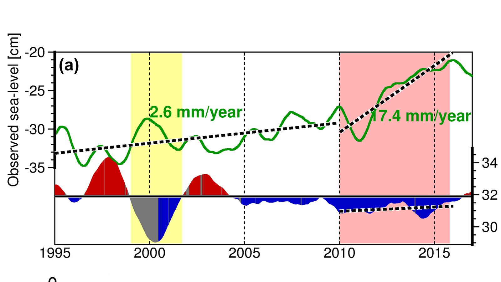
Tag: Gustavo Goni

New Research Showing Link between Florida Current and Pacific Ocean could Improve Sea Level, Climate Prediction

A recent study by scientists at NOAA’s Atlantic Oceanographic and Meteorological Laboratory (AOML) is the first to demonstrate that El Niño-Southern Oscillation (ENSO) temperature variations in the equatorial Pacific Ocean can help predict Florida Current transport anomalies three months later. The connection between Florida Current transport and ENSO is through ENSO’s impact on sea level on the eastern side of the Florida Straits, which plays a dominant role in the Florida Current transport variability on interannual time scales.

Read Full Article

Ocean Conditions Played a Major Role in the Intensification of Hurricane Michael (2018)

In a recent study published in AGU’s Journal of Geophysical Research – Oceans, scientists at AOML identified key ocean features that supported the rapid intensification of Hurricane Michael (2018), despite unfavorable atmospheric conditions for development. The study demonstrates the importance of using realistic ocean conditions for coupled (ocean-atmosphere) hurricane models in order to achieve the most accurate hurricane intensity forecasts.

Read Full Article

AOML Scientists Monitor How Heat and Water are Transported Through the Atlantic Ocean Using Field and Satellite Observations

In a recently published study, scientists at AOML present 28-year long (1993-2020) estimates of the Atlantic Meridional Overturning Circulation (AMOC) volume and heat transports at multiple latitudes by merging in-situ oceanographic and satellite observations. By combining ocean observations with satellite data, they were able to estimate the AMOC volume and heat transports in near real time. These data can be used to validate ocean models, to detect climate variability, and to investigate their impact on extreme weather events.

Read Full Article

Tracking Sargassum Inundation Potential for Coastal Communities

A recently published paper presents the Sargassum Inundation Report (SIR), a product that uses a satellite-based methodology to monitor from space areas with coastal inundation of pelagic Sargassum in the tropical Atlantic Ocean, Caribbean Sea, and Gulf of Mexico. The SIR was created as a response to the need to improve the monitoring and management of Sargassum influxes (e.g., coordinate clean-up), which have major economic, social, environmental, and public health impacts.

Read Full Article

Hurricane Gliders Return Home from 2020 Season

NOAA’s hurricane gliders are returning home after a successful journey during the 2020 hurricane season. These gliders were deployed off the coasts of Puerto Rico, Dominican Republic, the U.S. Virgin Islands, the Gulf of Mexico, and the eastern U.S. to collect data for scientists to use to improve the accuracy of hurricane forecast models.

Read Full Article

Robots Probe Ocean Depths in Mission to Fine-Tune Hurricane Forecasts

Four ocean gliders set off to sea this week to bring back data that scientists hope will improve the accuracy of hurricane forecast models.The robotic, unmanned gliders are equipped with sensors to measure the salt content (salinity) and temperature as they move through the ocean at different depths.  The gliders, which can operate in hurricane conditions, collect data during dives down to a half mile below the sea surface, and transmit the data to satellites when they surface.  

Read Full Article

Increasing water temperature tied to rapid sea level rise along the U.S. East Coast during 2010-2015

In a new article accepted for publication in the Geophysical Research Letters, Ricardo Domingues (CIMAS University of Miami & NOAA/AOML) and his coauthors explored the observed rapid sea level rise along the U.S. East Coasts during 2010-2015, which is linked to extensive flooding and “sunny day” flooding (or nuisance flooding) events in large urban areas including Norfolk, Baltimore, Charleston, and Miami, among others.

Read Full Article

Unmanned Ocean Gliders Help Improve Hurricane Forecasts

NOAA will soon launch a fleet of 15 unmanned gliders in the Caribbean Sea and tropical Atlantic Ocean this hurricane season to collect important oceanic data that could prove useful to forecasters. “If you want to improve prediction of how hurricanes gain strength or weaken as they travel over the ocean, it’s critical to take the ocean’s temperature and measure how salty it is,” said Gustavo Goni, an oceanographer at NOAA’s Atlantic Oceanographic and Meteorological Laboratory who is helping lead the glider research. “Not just at the surface, which we measure with satellites, but down into deeper layers of ocean waters.”

Read Full Article