
The Madden-Julian Oscillation is a patch of tropical thunderstorms that form across the Indian Ocean. These storms move slowly eastward across the Pacific Ocean over a period of 30 to 90 days.
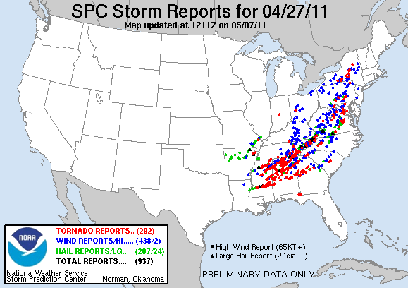
Several studies have found a correlation between an increase in U.S. tornado activity and how the thunderstorms of the Madden-Julian Oscillation pass across certain longitude bands in the tropical Pacific. Recently, scientists at NOAA’s Atlantic Oceanographic and Meteorological Laboratory (AOML) and the Cooperative Institute for Marine and Atmospheric Studies (CIMAS) explored the physical link between U.S. tornado activity and the Madden-Julian Oscillation. In a study recently published in the Journal of Climate (Kim et al., 2020), they showed that a series of key atmosphere-ocean processes are involved in the remote impact of Madden-Julian Oscillation on U.S. tornado activity.
When the moving thunderstorm is passing across Indonesia to the Pacific, the air across Central America becomes very dry due to changes in the Walker circulation that moves upper-level air westward and lower-level air eastward across the tropical Pacific. The drying air across Central America redirects the low-level air flow to enhance the supply of warm and moist air into the U.S. east of the Rockies. This enhanced supply of warm and moist air to the U.S. destabilizes the atmosphere to produce favorable conditions for tornado activity.
This study also showed that the identified link is applicable only during May-June-July season. Supported by a newly funded NOAA project “Subseasonal to Seasonal Severe Weather Prediction”, AOML scientists are currently looking at possible ways to apply this link in operational U.S. long-range weather forecasts. A successful application of this finding could help forecasters at NOAA’s Storm Prediction Center to extend the current forecast beyond the usual weather timescale (~ 8 days ahead) to develop a subseasonal (two to four weeks ahead) forecast model for U.S. tornado activity targeting May-June-July season. This would bolster AOML’s commitment to advancing “Subseasonal and Seasonal Forecasting Innovation”, one of the five focus areas of the Weather Research and Forecasting Innovation Act of 2017 (Weather Act).