
Each year, hurricanes and tropical storms can cause billions in damage and significant causalities around the world. The reduction of losses from hurricanes involves complex computer modeling coupled with observations and expert-decision making. Timely and accurate warnings of storm track and intensity allow people to prepare and evacuate, reducing the potential for catastrophic damage. NOAA’s Atlantic Oceanographic and Meteorological Laboratory (AOML) improves NOAA’s ability to provide timely and accurate warnings with its Hurricane Weather Research and Forecasting Model (HWRF).
AOML drives improvements to hurricane forecasts by leveraging expertise in tropical cyclone observations, research, and modeling. Our numerical weather modeling team uses HWRF to test new technology and advance hurricane prediction through data collection, assimilation, and experimental modeling. We collaborate with NOAA’s Environmental Modeling Center (EMC) to upgrade components of the HWRF model annually to reflect the latest advances in the tropical cyclone research community and provide our best guidance for track and intensity forecasts, which are used by the National Hurricane Center (NHC) every six hours for active tropical systems. Since its inception as an operational model in 2007, and with support of the Hurricane Forecast Improvement Project, the HWRF model continues to improve each year.
Advancing HWRF
AOML contributes to HWRF advancements through an experimental platform, called the Basin-Scale HWRF. AOML developed the Basin-Scale HWRF in collaboration with the University of Miami’s Cooperative Institute for Marine and Atmospheric Studies, NOAA’s Environmental Modeling Center, and the Developmental Testbed Center. With the Basin-Scale HWRF, AOML is able to test improvements such as better representations of storm physics and new observations, and transition them into the operational HWRF system, supporting NOAA’s ability to provide the best forecasts possible.
A key achievement of HWRF is the creation of high-resolution, storm-following “nests.” These nests improve forecasts of the near-storm environment and its inner core, including the capability to resolve thunderstorms and other features that affect storm intensity. The high-resolution, triple-nest approach is a key contributor to the model’s improvements in intensity forecast skill. An important component of the Basin-Scale HWRF is the inclusion of these nests for multiple storms at once, increasing our ability to model how one storm affects another. Basin-Scale HWRF also expanded its outer domain to cover a quarter of the globe. These unique components of Basin-Scale HWRF experiments have shown to improve forecast skill accuracy, especially when it comes to track forecasts at 3-5 days.
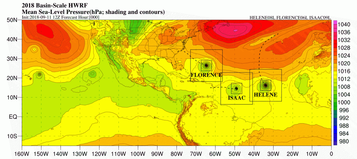
Basin-Scale HWRF animation showing the interaction of three simultaneous hurricanes in the Atlantic basin in 2017 (Irma, Jose, & Katia). Shading and contours show mean sea-level pressure (i.e., surface pressure), black boxes show the telescopic nests (down to 2km) that follow each storm, and black lines (dashed/solid) represent that observed track for each storm. The region shown in this map is approximately the size of the Basin-Scale HWRF outer domain.
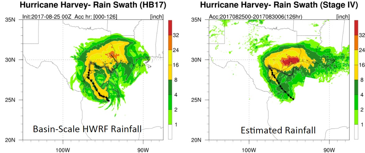
The Basin-Scale HWRF has also shown skill at forecasting precipitation, a hazard that can impact communities greatly as seen during the catastrophic flooding in Texas associated with Hurricane Harvey (2017). Integrating and modeling ocean conditions below the storm provides a better understanding of the nuances of storm behavior, including changes to intensity and rainfall.
Starting in 2018, Basin-Scale HWRF also incorporated the unique data collected in a hurricane environment from instruments such as the GPS dropwindsondes that parachute from hurricane hunter aircraft to the ocean surface measuring temperature, pressure, and wind dynamics. This was a critical upgrade to sync the Basin-Scale HWRF with the operational version of HWRF and to expand the Basin-Scale HWRF’s own operational capabilities. Data are assimilated into the models, and the resulting forecasts are scrutinized to improve the models through collaborations with partners throughout the tropical cyclone community. The results from experimental models (like the Basin-Scale HWRF) are tested rigorously by NOAA’s National Center for Environmental Prediction, with the goal of transitioning such models into operations so that they are available to NHC and NWS Weather Forecast Offices for public benefit. In addition to model developments to improve accuracy, new visual representations of the data are intended to make forecasts easy to understand and interpret.
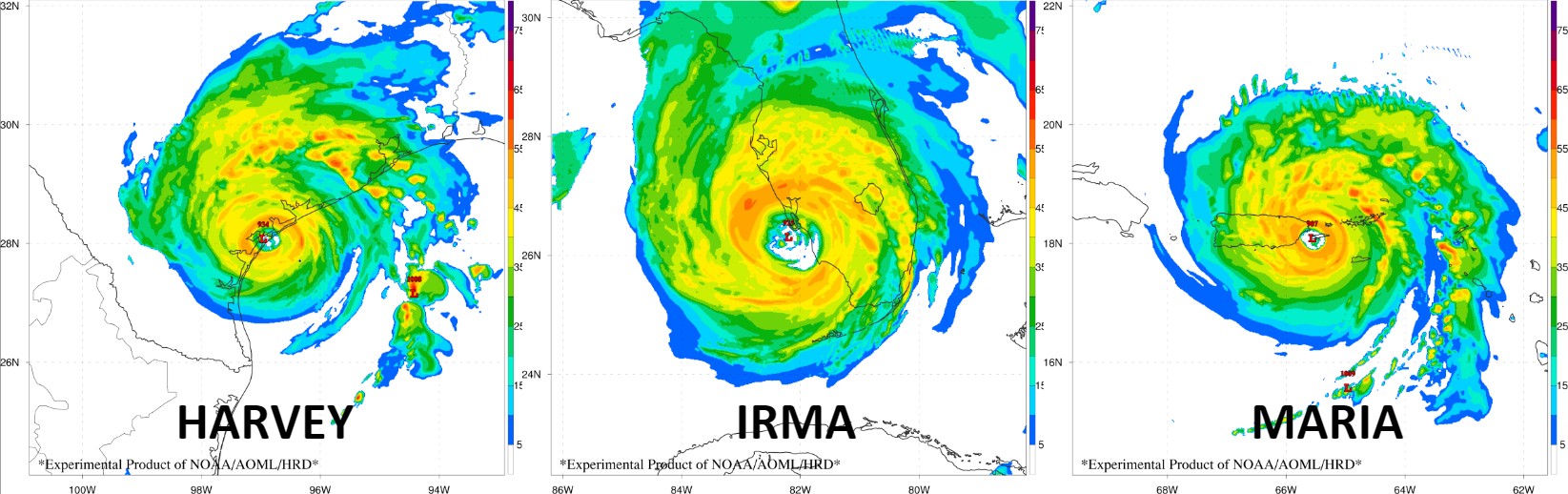
Simulated radar reflectivity from the Basin-Scale HWRF at the time of landfall for Major Hurricanes Harvey, Irma, and Maria.
Next Generation HWRF Goes Global
The improvements achieved by the Basin-scale HWRF model are now being integrated into a unified global model, the Finite Volume Cubed Sphere Global Forecasting System (FV3 GFS). The FV3GFS was created by NOAA’s Geophysical Fluid Dynamics Laboratory with support from NOAA’s Next Generation Global Prediction System (NGGPS) in collaboration with the Environmental Modeling Center, who plans to incorporate high-resolution hurricane forecasting directly in the global model. This approach will marry two important forecast capabilities: accurate track forecasts from the global model, and accurate intensity forecasts from the high-resolution nests developed in HWRF. This state-of-the-art global model is expected to achieve more accurate prediction of all hurricane-related hazards, including winds, rainfall, and storm surge.
Originally Published August 13, 2018 by Kristina Kiest