

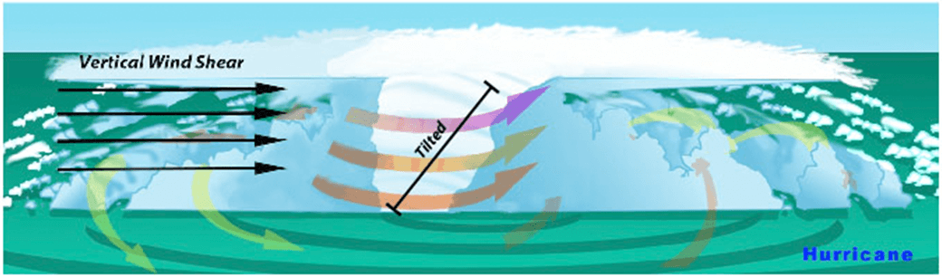
 Wind Shear
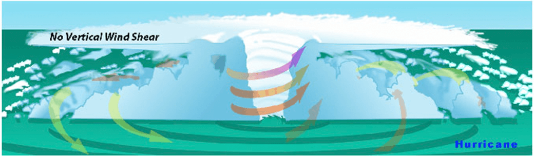 No Wind Shear
In the presence of vertical wind shear, a storm’s core structure will be tilted in relationship to the wind shear. This tilting will disrupt the flow of heat and moisture which inhibits the storm from developing and becoming stronger.
With the 2015 Atlantic hurricane season underway, researchers are pointing to the strong presence of El Niño as the major driver suppressing the development of tropical cyclones in the Atlantic basin. But what specific conditions are associated with El Niño that lead to a less than ideal environment for tropical cyclone development? Through research and observation, hurricane researchers know strong environmental wind shear is a major factor affecting potential hurricane development and growth. This hurricane season, AOML researchers are delving further into the relationship between wind shear and tropical cyclones.
What is wind shear?
Wind shear is the variation of the wind’s speed or direction over a short distance within the atmosphere. For tropical cyclones, wind shear is important primarily in the vertical direction, as these storms occupy a large vertical slice of the atmosphere from sea level to the top of the troposphere, which extends up to about 40,000 feet altitude in the tropics in summer.
How does wind shear affect tropical cyclone development?
Tropical weather systems are vulnerable to changes in the broader atmosphere surrounding them; often influenced by large features such as areas of high and low pressure, and fronts. If there’s too much wind, these weather systems have trouble organizing and developing into a tropical cyclone. As a tropical system forms, heavy thunderstorms build near the center. Given the right environment, these systems can eventually begin turning counter-clockwise (or cyclonically) in the northern hemisphere. With little to no wind shear, the turning within the tropical system is uniform and the storm becomes vertically aligned, helping to keep it intact and, likely, strengthening.
The most favorable condition for tropical cyclone development is the absence of wind shear. When wind shear is present, however, a storm’s core structure becomes vertically tilted in relationship to the wind shear, disrupting the flow of heat and moisture. Tropical cyclones are heat engines powered by the massive heat release associated with water vapor condensing into liquid water. Vertically-tilted systems are less efficient at drawing in warm and moist air from the surrounding ocean and will be less likely to develop and strengthen.
How does El Niño affect the presence or absence of wind shear?
El Niño is a climate phenomenon driven by above average ocean temperatures in the central and eastern tropical Pacific. While that warmth helps boost Pacific storm activity, the extra heat transferred to the atmosphere leads to a domino effect, altering climate around the globe.
Specifically, the instability over the warm equatorial Pacific during El Niño creates changes in the jet stream over the Northern Hemisphere, resulting in decreased wind shear in the Pacific and increased wind shear across much of the Caribbean and Atlantic. El Niño also increases the atmospheric stability, or resistance of the atmosphere to vertical motion, in the Atlantic basin, which suppresses hurricane activity.
Can a storm persist despite the existence of wind shear?
AOML researchers are focusing on particular characteristics of developed tropical cyclones that enable them to persist despite increased levels of wind shear. The theoretical work focuses mainly on how a tropical cyclone’s wind structure is disrupted by wind shear.
Using a simple mathematical model, researchers can estimate the degree to which the center of the storm becomes vertically tilted based on the cloudiness within the eyewall, as well as the structure of the wind outside the eyewall. By modeling the development of storm tilt, a better understanding of a tropical cyclone’s behavior is gained in the presence and absence of wind shear.
Results suggest that tropical cyclones are more likely to resist disruption by vertical wind shear when clouds cover a large portion of the eyewall and when winds decrease less rapidly from the eye. These model simulations show promise in understanding the fundamental physical processes driving intensity and structural changes of tropical cyclones due to environmental factors.
A Doppler wind lidar instrument added to NOAA’s hurricane hunter aircraft this season will assist AOML researchers in collecting observational data to better understand the wind environment around tropical cyclones. The lidar instrument is used to collect, process, and transmit atmospheric data from within a hurricane, enabling NOAA to sample the winds inside the eyewall of storms. By leveraging observational expertise and new data combined with modeling, AOML researchers hope to learn more about the wind environment and the interaction between wind shear and tropical cyclones, allowing them to better predict a hurricane’s future activity and intensity.
Originally Published by Edward Pritchard, AOML
