
Early on the morning of August 29th, 2005, Hurricane Katrina made landfall on the Louisiana delta region and the Mississippi coast. The storm surge brought enormous damage to the Gulf Coast and, when the levees around New Orleans failed, a great number of fatalities. Coming amidst the very busy 2005 hurricane season, Katrina brought death and destruction not seen in a U.S. land-falling hurricane in decades.
Katrina formed out of a complex interaction of a tropical wave, the mid-level remnants of Tropical Depression 10, and an upper-tropospheric trough. The disturbed weather consolidated into a circulation on August 24th over the Bahama Islands. As it moved northward through the archipelago, it strengthened into a Tropical Storm then turned westward toward Florida. As a NOAA P-3 Hurricane Hunter aircraft flew a reconnaissance mission into Katrina, it reached hurricane strength, then swerved to a southwesterly course as it came ashore in south Florida. The hurricane brought drenching rains to the peninsula, up to 14 inches (35.5 cm) in some areas.
Katrina diminished only slightly during its trek across Florida. Once it reached the warm waters of the Gulf of Mexico, it quickly regained hurricane status and began to rapidly intensify. While one of the two NOAA P-3s flew a series of Synoptic Surveillance missions, dropping sondes in an effort to improve the track-forecast models, another aircraft flew two missions into the hurricane during its intensification stage, once on the 27th and another on the 28th when Katrina reached Category 5 status with its winds reaching a peak sustained wind speed of 170 mph (275 km/hr).

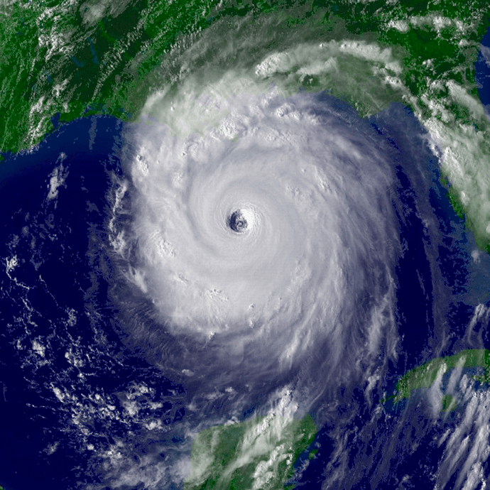
Thankfully, the hurricane began a rapid weakening as it approached the Gulf Coast. A landfall flight by a NOAA P-3 documented this decline and tracked the center as it passed over the Mississippi delta and made final landfall near the Louisiana/Mississippi border. The highest sustained wind speeds at landfall were estimated by the National Hurricane Center at 120 mph (193 km/hr). Even though the top winds were much less than before, the water pushed inland by the storm was great. Pass Christian, Mississippi observed nearly 28 feet of surge, and the Gulf waters intruded six miles inland. Ninety percent of buildings within a half mile of the coast suffered substantial damage, and thousands of structures were completely destroyed.
However, it wasn’t until the hurricane eye had passed well inland that the levees that protected New Orleans began to fail. Over 50 breaches in the defense opened up, flooding large portions of the city that lay below sea level. Homes and businesses were inundated and would remain so for weeks after the storm, and over a thousand people who had not evacuated either drowned in the flood or in the days afterward from exposure or lack of water and food. Katrina caused over US $100 billion in damage and an estimated death toll of almost 1800.
The data collected from the NOAA research flights proved extremely important to researchers. It helped them better understand how storms form, evolve, and change in intensity. This understanding has led to improvements in NOAA’s hurricane models as well as our ability to better prepare communities. The data collected has also contributed to a significant number of papers written by Hurricane Research Division scientists:
- Aberson, S. D., M. L. Black, R. A. Black, J. J. Cione, C. W. Landsea, F. D. Marks Jr., and R. W. Burpee, 2006: Thirty years of tropical cyclone research with the NOAA P-3 aircraft. Bull. Amer. Meteor. Soc., 87, 1039–1055.
- Houze, R. A., S. S. Chen, W.-C. Lee, R. F. Rogers, J. A. Moore, G. J. Stossmeister, M. M. Bell, J. L. Cetrone, W. Zhao, and S. R. Brodzik, 2006: The Hurricane Rainband and Intensity Experiment: Observations and modeling of Hurricanes Katrina, Ophelia, and Rita (2005). Bull. Amer. Met. Soc., 87, 1503-1521
- Rogers, R., S. Aberson, M. Black, P. Black, J. Cione, P. Dodge, J. Gamache, J. Kaplan, M. Powell, J. Dunion, E. Uhlhorn, N. Shay, and N. Surgi, 2006: The Intensity Forecasting Experiment: A NOAA Multiyear Field Program for Improving Tropical Cyclone Intensity Forecasts. Bull. Amer. Meteor. Soc., 87, 1523–1537.
- Powell, M. D., and T. A. Reinhold, 2007: Tropical Cyclone Destructive Potential by Integrated Kinetic Energy. Bull. Amer. Meteor. Soc., 88, 513–526.
- Uhlhorn, E. W., P. G. Black, J. L. Franklin, M. Goodberlet, J. Carswell, and A. S. Goldstein, 2007: Hurricane Surface Wind Measurements from an Operational Stepped Frequency Microwave Radiometer. Mon. Wea. Rev., 135, 3070–3085.
- Halliwell. G. R. Jr., L. K. Shay, S. D. Jacob, O. M. Smedstad, and E. W. Uhlhorn, 2008: Improving Ocean Model Initialization for Coupled Tropical Cyclone Forecast Models Using GODAE Nowcasts. Mon. Wea. Rev., 136, 2576–2591.Powell, M. D., E. W. Uhlhorn, and J. D. Kepert, 2009: Estimating Maximum Surface Winds from Hurricane Reconnaissance Measurements. Wea. Forecasting, 24, 868–883.
- Bunya, S., J. C. Dietrich, J. J. Westerink, B. A. Ebersole, J. M. Smith, J. H. Atkinson, R. Jensen, D. T. Resio, R. A. Luettich, C. Dawson, V. J. Cardone, A. T. Cox, M. D. Powell, H. J. Westerink, and H. J. Roberts, 2010: A High-Resolution Coupled Riverine Flow, Tide, Wind, Wind Wave, and Storm Surge Model for Southern Louisiana and Mississippi. Part I: Model Development and Validation. Mon. Wea. Rev., 138, 345–377.
- Dietrich, J. C., S. Bunya, J. J. Westerink, B. A. Ebersole, J. M. Smith, J. H. Atkinson, R. Jensen, D. T. Resio, R. A. Luettich, C. Dawson, V. J. Cardone, A. T. Cox, M. D. Powell, H. J. Westerink, and H. J. Roberts, 2010: A High-Resolution Coupled Riverine Flow, Tide, Wind, Wind Wave, and Storm Surge Model for Southern Louisiana and Mississippi. Part II: Synoptic Description and Analysis of Hurricanes Katrina and Rita. Mon. Wea. Rev., 138, 378–404.
- Lorsolo, S., J. A. Zhang, F. Marks Jr., and J. Gamache, 2010: Estimation and Mapping of Hurricane Turbulent Energy Using Airborne Doppler Measurements. Mon. Wea. Rev., 138, 3656–3670.Aberson, S. D., 2010: 10 Years of Hurricane Synoptic Surveillance (1997–2006). Mon. Wea. Rev., 138, 1536–1549.
- Guimond, S. R., M. A. Bourassa, and P. D. Reasor, 2011: A Latent Heat Retrieval and Its Effects on the Intensity and Structure Change of Hurricane Guillermo (1997). Part I: The Algorithm and Observations. J. Atmos. Sci., 68, 1549–1567.
- DiNapoli, S. M., M. A. Bourassa, and M. D. Powell, 2012: Uncertainty and Intercalibration Analysis of H*Wind. J. Atmos. Oceanic Technol., 29, 822–833.
- Black, R. A., and J. Hallett, 2012: Rain Rate and Water Content in Hurricanes Compared with Summer Rain in Miami, Florida. J. Appl. Meteor. Climatol., 51, 2218–2235
- Gopalakrishnan, S. G., S. Goldenberg, T. Quirino, X. Zhang, F. Marks Jr., K.-S. Yeh, R. Atlas, and V. Tallapragada, 2012: Toward Improving High-Resolution Numerical Hurricane Forecasting: Influence of Model Horizontal Grid Resolution, Initialization, and Physics. Wea. Forecasting, 27, 647–666.
- Rogers, R., S. Lorsolo, P. Reasor, J. Gamache, and F. Marks, 2012: Multiscale Analysis of Tropical Cyclone Kinematic Structure from Airborne Doppler Radar Composites. Mon. Wea. Rev., 140, 77–99.
- Li, X., J. A. Zhang, X. Yang, W. G. Pichel, M. DeMaria, D. Long, and Z. Li, 2013: Tropical Cyclone Morphology from Spaceborne Synthetic Aperture Radar. Bull. Amer. Meteor. Soc., 94, 215–230.
- Klotz, B. W., and E. W. Uhlhorn, 2014: Improved Stepped Frequency Microwave Radiometer Tropical Cyclone Surface Winds in Heavy Precipitation. J. Atmos. Oceanic Technol., 31, 2392–2408.
- Uhlhorn, E. W., B. W. Klotz, T. Vukicevic, P. D. Reasor, and R. F. Rogers, 2014: Observed Hurricane Wind Speed Asymmetries and Relationships to Motion and Environmental Shear. Mon. Wea. Rev., 142, 1290–1311.
- Wang, J., K. Young, T. Hock, D. Lauritsen, D. Behringer, M. Black, P. G. Black, J. Franklin, J. Halverson, J. Molinari, L. Nguyen, T. Reale, J. Smith, B. Sun, Q. Wang, and J. A. Zhang, 2015: A Long-Term, High-Quality, High-Vertical-Resolution GPS Dropsonde Dataset for Hurricane and Other Studies. Bull. Amer. Meteor. Soc., 96, 961–973.Powell, M .D., S. T. Murillo, P. P. Dodge, E. W. Uhlhorn, J. F. Gamache, V. Cardone, A. Cox, S. Otero, N. Carrasco, B. Annane, and R. St. Fleur. Reconstruction of Hurricane Katrina’s wind fields for storm surge and wave hindcasting. Ocean Engineering, 37, 26-36.