
Tropical Atlantic Current Observations Study
Advancing Our Understanding of Ocean Circulation and Mixing
JUMP TO DATA
OR SCROLL TO LEARN MORE
Who We Are
The Tropical Atlantic Current Observations Study (TACOS) is a pilot study focused on advancing understanding of ocean circulation and mixing and its impact on sea surface temperatures and the atmosphere. Using acoustic current meters augmented to the existing NOAA PIRATA Northeast Extension 4°N 23°W mooring, TACOS provides a novel time series of a horizontal velocity and its vertical shear in regions with strong ocean-atmosphere coupling on weather and climate timescales. Future deployments will target the hurricane main development region and the Atlantic oxygen minimum zone.
Our Objectives
1. Improve our understanding of how ocean currents vary over time, from subdiurnal to interannual.
2. Improve our understanding of how ocean currents impact sea surface temperatures and the atmosphere in key regions of change observed by PIRATA moorings, such as the intertropical convergence zone (ITCZ), the Atlantic main hurricane development region, and the Atlantic oxygen minimum zone.
3. Develop new long-term time-series data of horizontal velocity and vertical shear observations in key under-sampled regions.
4. Provide ocean current data that can be used for validation of numerical models and marine weather forecasts. Propose future enhancements to the PIRATA network, which presently only observes velocity near the surface at most moorings.


| Renellys Perez, Ph.D.
AOML Lead Principal Investigator
| Gregory Foltz, Ph.D.
Co-Principal Investigator
Top News
Ocean Month: Exploring and understanding our ocean through research cruises
June 25, 2025
Research cruises are essential for scientists to collect data, deploy instrumentation, and maintain ocean observing systems. NOAA regularly conducts research at sea to study the ocean and atmosphere, advancing our understanding of the ocean, monitoring ocean conditions, and ensuring sustainable fisheries and healthy marine habitats. These expeditions provide essential data for weather prediction, ocean acidification […]


Read More News
Research Impacts & Key Findings
On January 12, 2020, the Tropical Atlantic Current Observations Study (TACOS) recorded its 25,000th hourly upper-ocean velocity profile.
As of March 2020, TACOS has been measuring upper-ocean velocity profiles for 3 years.
Background
Introduction
The Tropical Atlantic Current Observations Study (TACOS) is a pilot study aimed to further the understanding of how the upper ocean circulation impacts ocean advection and mixing, sea surface temperatures (SSTs), and atmospheric processes. Ocean current velocity—both zonal (east-west) and meridional (north-south)—varies with depth and time. These fluctuations are driven by winds near the surface and density differences throughout the water column, and as a result, the current speed and direction can change.
As density changes drive currents, the moving water tends to mix with its new surroundings and change its properties. For example, diurnal to seasonal fluctuations of ocean currents strongly influence SST distributions in the tropical Atlantic. These fluctuations can be accomplished through horizontal motion (advection) and vertical motion (upwelling or downwelling).
Certain atmospheric processes are affected by surface ocean conditions. Warm sea surface temperatures provide energy for atmospheric convection, which creates thunderstorms and rain. In certain circumstances, warm sea surface temperatures can provide excess energy that strengthens the atmospheric circulation of hurricanes.
About TACOS
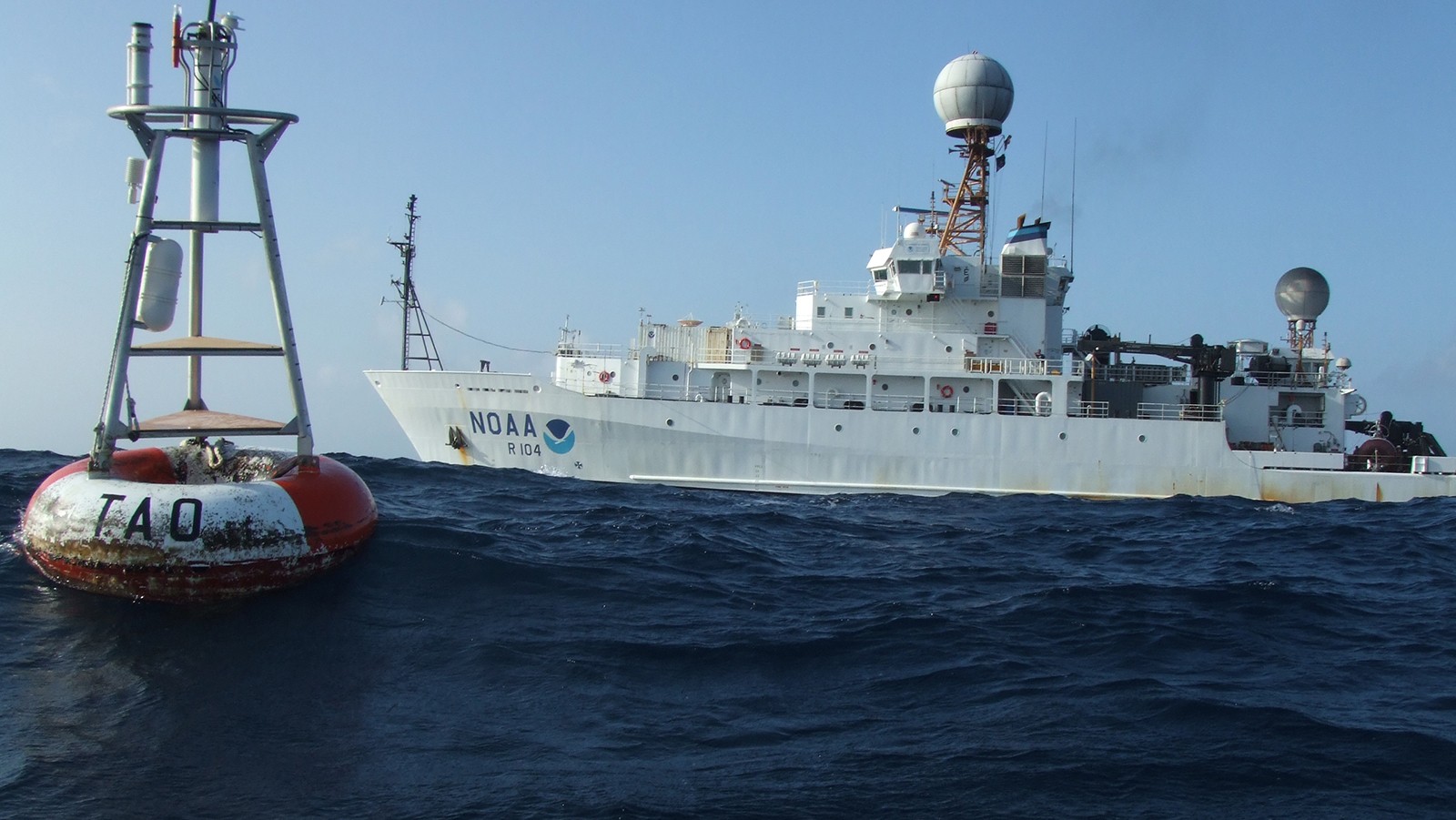
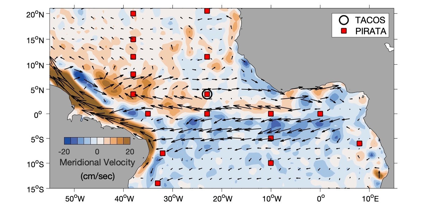
TACOS uses 10 acoustic current meter sensors to augment the 4°N 23°W PIRATA mooring with additional sensors between 7 and 87 m depth. Prior to TACOS, there was a lack of vertical high resolution ocean current measurements north of the equator, specifically in the Intertropical Convergence Zone (ITCZ); the ITCZ is a key region influencing tropical weather and climate.
With the implementation of TACOS, we now have prolonged observations of current and vertical shear measurements that were previously nonexistent in this location. By establishing a long-term time series of current observations at 4°N 23°W, we can better understand how ocean currents, vertical shear, advection, and mixing can modify SSTs and overlying atmospheric processes. Additionally, we can use TACOS observations to validate tropical weather models and forecasts, which presently rely on lower resolution ocean measurements. Future deployments will take place at 20°N 38°W and 12°N 38°W.
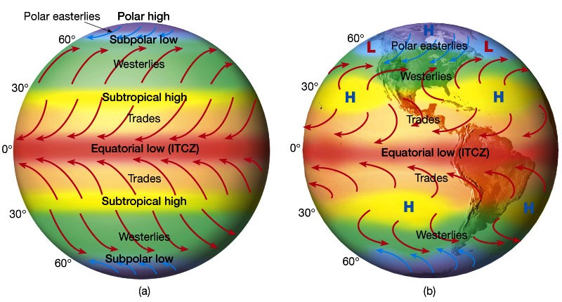
Inter-Tropical Convergence Zone
The Inter-tropical convergence zone (ITCZ) is a region near the equator, where the trade winds of the Northern and Southern Hemispheres come together. The northeast trade winds in the northern hemisphere converge with southeast winds from the Southern Hemisphere (shown below). Due to the intense solar heating near the equator, the warm, moist air is forced up into the atmosphere. As the air rises it expands and cools, releasing the moisture in a persistent series of showers and thunderstorms around the Earth’s midsection.
Seasonal shifts in the location of the ITCZ drastically affects rainfall in many equatorial regions, resulting in the wet and dry seasons of the tropics rather than the cold and warm seasons of higher latitudes.
History of the Project
PIRATA is an ongoing joint project between Brazil, France, and the United States that uses moored sensors to measure upper ocean temperature, salinity, velocity, and near-surface atmospheric parameters. By increasing the number of velocity sensors at the 4°N 23°W PIRATA Northeast Extension mooring, TACOS is helping us develop a more complete understanding of the mechanisms driving upper ocean heat advection and vertical mixing. To learn more about PIRATA you can visit NOAA’s PIRATA Northeast Extension page.
TACOS sensors were first deployed on the 4°N 23°W PIRATA Northeast Extension mooring on March 6 2017 and recovered on March 26 2018. Since the first deployment, two other deployments have occurred (2018 and 2019) and the next is being prepared for an anticipated late fall 2021 deployment at the 20°N 38°W PIRATA Northeast Extension mooring. The 20°N 38°W mooring was chosen to expand our understanding of ocean current and vertical shear fluctuations in the Atlantic main hurricane development region.
How Does TACOS Work?
TACOS acoustic current meters add to the measurements being made at the 4°N 23°W PIRATA mooring. By default, the PIRATA mooring at this location has only one current sensor that measures near-surface velocity (at 12 m depth). With the additional TACOS sensors, we get a vertical profile from the near surface to a depth of almost 90 m. The acoustic current meters measure both zonal and meridional components of the currents every hour in near-real-time, and are combined with thermistors that provide concurrent temperature measurements. Higher temporal resolution data are recorded internally and obtained when the instrument is recovered. Watch the video to the right to see an animation of TACOS sensors deployed on a mooring line.
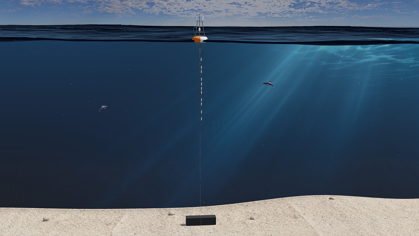
TACOS schematic and video courtesy of Bertrand Dano, AOML scientist.
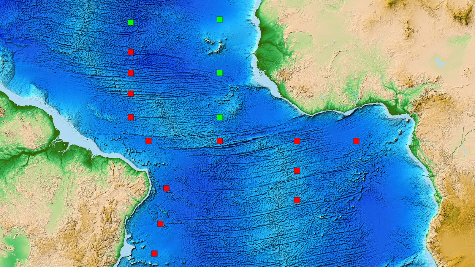
Mooring Array
Multi-year time series from TACOS have been collected at the 4°N 23°W mooring in the PIRATA Northeast Extension mooring array. Future deployments will target the hurricane main development region and the Atlantic oxygen minimum zone. In the image below, the TACOS mooring is denoted by a yellow hotspot amongst the PIRATA and PIRATA Northeast Extension mooring arrays.
pnedata anchor
Data
March 1 - March 29, 2019*
PNE2019 began on March 1, 2019 in Charleston, South Carolina on the NOAA R/V Ronald H. Brown, and ended early on March 29, 2019 in Charleston, South Carolina. Renellys Perez (NOAA/AOML) was the chief scientist. Science conducted during PNE2019 was greatly curtailed due to a reduction of almost two weeks at sea due to a series of delays/issues. Three moorings were serviced (20N, 38W; 20.5N, 23W; and 11.5N, 23W). The final mooring (4N, 23W) was serviced in May 2019 aboard the UNOLS R/V Thomas G. Thompson. Only 12 CTD casts were conducted due to limited time, and 14 surface drifters for NOAA’s Global Drifter program and 22 profiling floats for the Argo program were also deployed in areas with limited data coverage. AEROSE deployed 101 radiosondes and 8 ozonesondes during the cruise. Sargassum sightings were recorded by student volunteers.
*Report & Data Links Forthcoming
Sharing Resources Delivers Results.
Expanding Reach Through Partnerships.
TACOS is funded by AOML with additional support provided by the Global Ocean Monitoring and Observation (GOMO) program through the PIRATA Northeast Extension (PNE) program. TACOS deployments are made possible through collaboration with NOAA’s Pacific Marine Environmental Laboratory (PMEL) and the multi-national PIRATA program. Data from all of the PIRATA moorings can be obtained here.
Featured Publication

Perez, R. C., Foltz, G. R., Lumpkin, R., & Schmid, C. (2019). Direct measurements of upper ocean horizontal velocity and vertical shear in the tropical North Atlantic at 4 Ν, 23 W. Journal of Geophysical Research: Oceans, 124(6), 4133-4151.
Abstract: The Tropical Atlantic Current Observations Study measured upper ocean horizontal velocity from a mooring at 4°N, 23°W, at discrete depths between 7 and 87 m, in order to observe the temporal and vertical structure of the currents. Between March 2017 and March 2018, mean zonal velocity and vertical shear were strongest between 32 and 37 m. Near‐surface mean eastward currents during this period were weaker than the long‐term mean but within the range of previously observed values given the high interannual variability. Interannual variability of the zonal velocity exceeded that of the meridional velocity, was primarily geostrophically driven, and was strongly influenced by the large‐scale currents. Energetic tropical instability waves (TIWs) were observed in early summer and late fall of 2017…
Read Full Paper.
Direct Measurements of Upper Ocean Horizontal Velocity and Vertical Shear in the Tropical North Atlantic at 4°Ν, 23°W
Perez, R. C., Foltz, G. R., Lumpkin, R., & Schmid, C. (2019). Direct measurements of upper ocean horizontal velocity and vertical shear in the tropical North Atlantic at 4 Ν, 23 W. Journal of Geophysical Research: Oceans, 124(6), 4133-4151.
Abstract: The Tropical Atlantic Current Observations Study measured upper ocean horizontal velocity from a mooring at 4°N, 23°W, at discrete depths between 7 and 87 m, in order to observe the temporal and vertical structure of the currents. Between March 2017 and March 2018, mean zonal velocity and vertical shear were strongest between 32 and 37 m. Near‐surface mean eastward currents during this period were weaker than the long‐term mean but within the range of previously observed values given the high interannual variability. Interannual variability of the zonal velocity exceeded that of the meridional velocity, was primarily geostrophically driven, and was strongly influenced by the large‐scale currents. Energetic tropical instability waves (TIWs) were observed in early summer and late fall of 2017…
Read Full Paper.

Related Publications
2022
Tuchen, F. P., Brandt, P., Hahn, J., Hummels, R., Krahmann, G., Bourlès, B., … & Toole, J. M. (2022). Two decades of full-depth current velocity observations from a moored observatory in the central equatorial Atlantic at 0 N, 23 W. Frontiers in Marine Science, 9:9109792021
Specht, M. S., Jungclaus, J., & Bader, J. (2021). Identifying and characterizing subsurface tropical instability waves in the Atlantic Ocean in simulations and observations. Journal of Geophysical Research: Oceans, 126, e2020JC017013.2020
Foltz, G. R., Hummels, R., Dengler, M., Perez, R. C., & Araujo, M. (2020). Vertical turbulent cooling of the mixed layer in the Atlantic ITCZ and trade wind regions. Journal of Geophysical Research: Oceans, 125(2), e2019JC015529.2019
Perez, R. C., Foltz, G. R., Lumpkin, R., & Schmid, C. (2019). Direct measurements of upper ocean horizontal velocity and vertical shear in the tropical North Atlantic at 4 Ν, 23 W. Journal of Geophysical Research: Oceans, 124(6), 4133-4151.