Argo Program
An Array of Profiling Floats Observing the Ocean in Real-Time
Who We Are
What We Do
Argo is an international program that collects information from inside the ocean using free drifting profiling floats. These floats drift with the ocean currents and move up and down between the surface and a mid-water level. The floats are distributed over the global ocean to measure temperature and salinity in the upper 2,000 meters. They annually provide 100,000 temperature/ salinity profiles and reference velocity measurements per year. Argo data are used to initialize ocean and coupled (i.e., ocean-atmosphere) forecast models and for dynamical model testing. This broad-scale global array of temperature/salinity profiling floats is a major component of the global ocean observing system.
Our Objectives
1. Provide a quantitative description of the evolving state of the upper ocean by collecting temperature and salinity profiles from the surface to 2,000 meters depth.
2. Improve weather and climate forecasts through the assimilation of Argo data in ocean and coupled (ocean and atmosphere) forecast models.

| Candice Hall
Principal Investigator of the AOML Argo Program and Manager of the US Argo Data Assembly Center
| Jodi Brewster
Software Developer, Quality Control and BGC-Argo

| Abdallah Daher
Software developer and Quality Control

| Cedrick Estelhomme
Data Processing and Quality Control


| Jennifer McWhorter
Biogeochemical-Argo co- Principal Investigator

| Jaya Nair
Software developer and Quality Control

| Brandon Navarro
Quality Control, DMQC, BGC-Argo and Web Graphics

Top News
In the wake of hurricanes: satellites and robots reveal an altered biogeochemical landscape
February 23, 2026
On August 30, 2023, Hurricane Idalia made landfall as a major Hurricane in Florida’s Big Bend after meandering through the northwestern Caribbean and intensifying over the warm waters of the Gulf of America. In its aftermath, damage on land was immediately visible, but observations from satellites and ocean-going robots revealed that the ocean was also […]


Read More News
Research Findings
From its inception, Argo has made its data freely available to the operational and research communities, as well as the general public. This open-data policy, coupled with the exceptional data coverage, has driven an explosion in ocean and climate research with over 4,000 papers and 250 PhD theses using Argo data.
Source: Argo Data 1999–2019: Two Million Temperature-Salinity Profiles and Subsurface Velocity Observations From a Global Array of Profiling Floats (here)
Argo data have shown the upper 2,000 meters has captured roughly ~90% of the anthropogenic change in ocean heat content over the last two decades. Temperatures in the upper ~600 m fluctuate with shorter-term climate events like El Niño-Southern Oscillation, while deeper waters display a more consistent warming trend. The 700–2,000 m ocean layer accounts for approximately one-third of the warming of the 0–2000 m layer of the World Ocean.
Source: World ocean heat content and thermosteric sea level change (0–2000 m), 1955–2010 (here)
Key Operational Impacts
Argo Operational Uses
National Oceanic and Atmospheric Administration
Real Time Weather Forecasting
• The NWS uses Argo float data to improve the accuracy of ocean-atmosphere interaction models. This data helps enhance short-term weather forecasts, especially for regions influenced by ocean currents and sea surface temperatures
Marine and Coastal Forecasts
• Argo data supports marine weather forecasting, including predicting conditions for shipping, fishing, and recreational boating. This information is crucial for issuing advisories and warnings for maritime operations in coastal zones
Severe Weather Prediction
• Argo float data, particularly near real time ocean temperature, is vital for improving forecasting capabilities for tropical storms, cyclones, and other ocean-driven weather events.
National Hurricane Center (NHC)
Validate and Refine Hurricane Forecasts
• Evaluate and calibrate ocean current models, which improves predictions of hurricane paths and intensities.
• Utilize Argo floats to improve our understanding of oceanic conditions that influence storm development and behavior.
United States Navy and other naval forces
• Route Optimization: Supports efficient fuel usage and speed adjustments based on ocean currents and water density variations.
• Hurricane Prediction: Assists in predicting storm intensity and paths, aiding in fleet protection.
• Arctic & Deep-Sea Operations: Helps in strategic planning for operations in changing environments, such as the Arctic.
• Thermocline Detection: Knowing the depth of the thermocline helps submarines hide from and detect enemy vessels.
United States Coast Guard and other maritime agencies
• Survivability Estimates: Temperature and salinity data help assess hypothermia risks for individuals lost at sea.
• Iceberg and Sea Ice Monitoring: Assists in Arctic and Antarctic operations by tracking changes in ocean temperature that influence ice formation.
• Chemical and Hazardous Spill Response: Supports modeling the dispersion of pollutants in the ocean.
• Tsunami Monitoring: While not directly a tsunami detection system, Argo data contributes to models that predict sea level changes.
• Marine Ecosystem Monitoring: Helps monitor changes in ocean health, including temperature shifts that affect fish populations.
• Maritime Domain Awareness: Supports broader ocean surveillance for national security and law enforcement.
United States Army and other armed forces
• Environmental Monitoring: For long-term planning, the Army may use Argo data to understand shifting ocean temperatures, which can have indirect impacts on global and regional security concerns related to environmental changes.
• Resupply Missions: In remote or harsh environments, understanding ocean conditions can aid the planning of resupply routes across water, ensuring the safety and efficiency of military transport.
United States Department of Agriculture
• Argo floats measure ocean productivity, such as net primary production (NPP), which is influenced by ocean conditions like nutrient availability and light. These factors can affect atmospheric moisture and precipitation patterns, impacting agricultural productivity. For example, a study using BGC Argo floats provided year-round NPP estimates in the western North Atlantic, highlighting how ocean conditions influence atmospheric patterns that can affect crop yields. The USDA integrates this oceanic data into crop models to assess potential impacts on crop production, particularly in regions sensitive to ocean-driven climate variations.
• Argo data helps track these ocean phenomena, which are inputs for tools like the U.S. Drought Monitor—a key USDA decision-support system for disaster relief and planning.
• Argo floats provide critical ocean data—especially on temperature, salinity, and ocean currents—which feed into global weather models.
National Aeronautics and Space Administration
NOAA OAR ORF United States National Ice Center (US NIC)
Shipping Industry
– Avoiding strong head currents that increase fuel consumption.
– Using favorable currents to save fuel and time.
– Avoid severe weather systems like cyclones or rough seas.
– Navigate more safely in open ocean routes.
– The International Maritime Organization’s Initial Strategy on the Reduction of Greenhouse Gas (GHG) Emissions from Ships.
– Ballast water management, where understanding salinity layers helps assess ecological risk.
– Safer port approaches.
– Efficient tugboat deployment and docking in challenging currents.
• Argo floats contribute to data lakes used in training AI routing algorithms.
Federal Aviation Administration
United States Geological Survey
Marine Tourism & Recreation
• NCEI provides access to data for global, 12-month forecasts of 13 key variables. NMME data is daily or 6-hourly with a 1º by 1º spatial resolution. Most NMME datasets have 10 realizations for each variable.
• The University of Miami hosts the NMME products that are used by many U.S.-based and international entities, both private and public, for regional or otherwise tailored weather and ocean forecasts. Argo floats are an essential data source for the NMME.
Background
What is Argo?
Argo, the broad-scale global array of temperature/salinity profiling floats, is a major component of the ocean observing system. The Argo program is an international program that began in 1999 to measure temperature and salinty of the upper 2,000 meters of the global ocean. Conceptually, Argo builds on the existing upper-ocean thermal networks, extending their spatial and temporal coverage, depth range and accuracy, and enhancing them through the addition of salinity and velocity measurements. The name Argo was chosen because of the program’s partnership with the Jason earth observing satellites that measure the shape of the ocean surface. In Greek mythology Jason sailed on his ship the Argo.
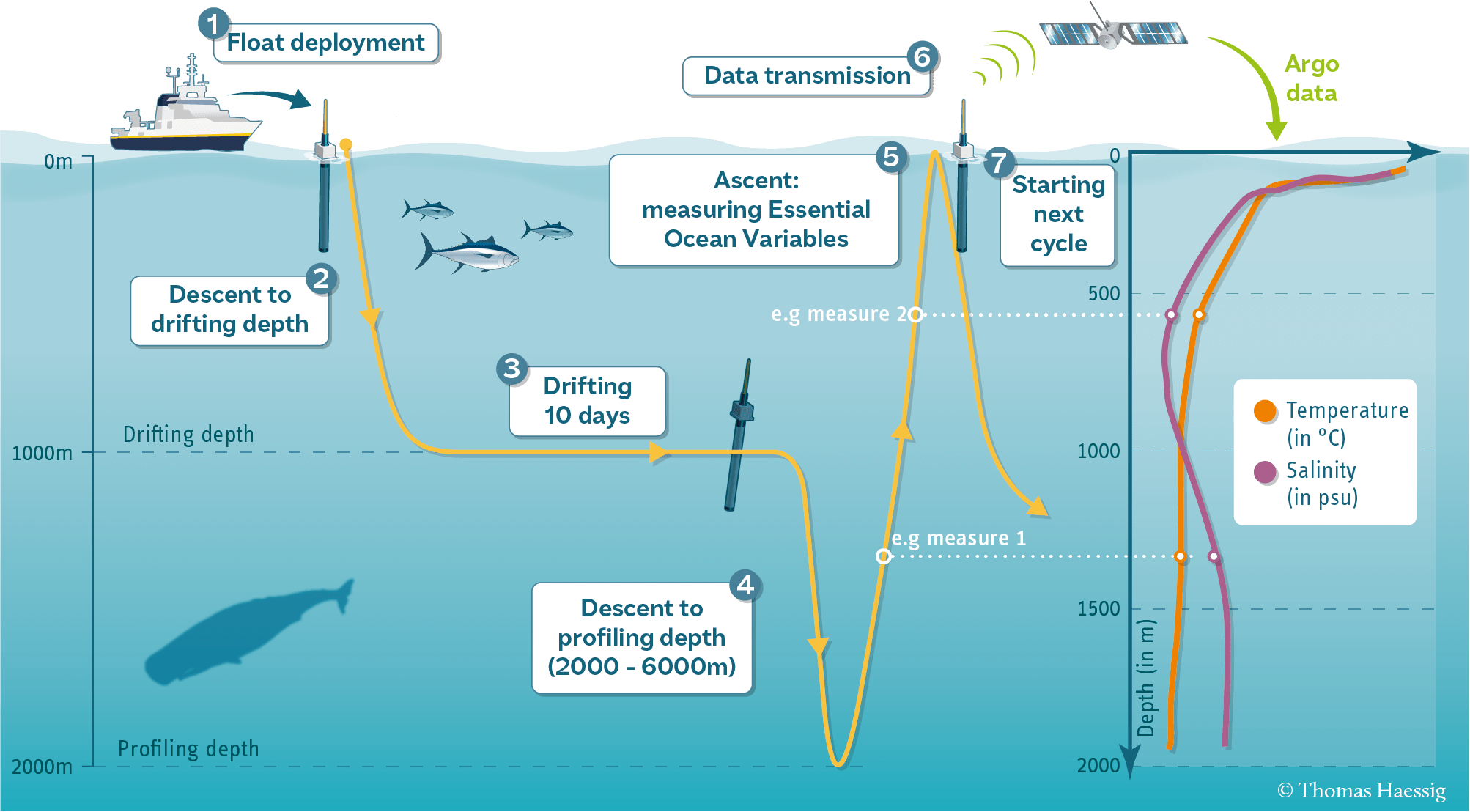
How does it work?
The standard Argo float mission is known as “park-and-profile.” The float descends to a target depth of 1,000 meters to “park” and drift with the ocean currents. Every 10 days the floats descend to 2,000 meters and then collect a vertical profile of temperature and salinity during ascent to the surface. When a float surfaces, the data are transmitted and the float’s position is determined either by GPS or by Système Argos (France).
Motivation for the Argo Program
The data that Argo collects describe the temperature and salinity of the water, and some of the floats measure other properties that describe the biology/chemistry of the ocean. The primary reason for collecting these data is to help us understand the ocean’s role in earth’s climate to make improved estimates of how it will change in the future. Argo float measurements compared with Jason satellite observations continue to provide new insights into how the ocean “works” that can be used to improve climate models.
At present (2021) Argo collects 12,000 data profiles every month (400 per day). Researchers plan to continue collecting Argo data for as long as those data remain a vital tool for a wide range of ocean applications, including the detection of climate change.
Maintaining the Global Array
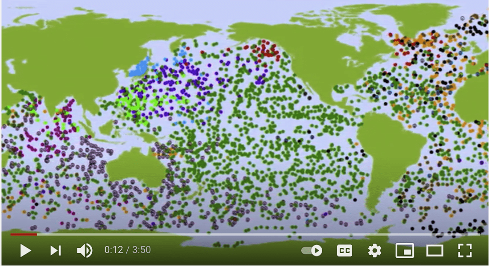
Deployments of Argo floats began in 1999, and the 3,000-float goal was reached in November 2007. Argo collected its one-millionth profile in October 2012, its two-millionth profile in September 2018, and its three-millionth profile in July 2024. The Argo Information Centre (AIC) has created an interactive map of the Argo float array shown below. This map gives you the ability to zoom, scroll, or drag the map, and click on a float to get its ID number.
To view the data for a particular float click on the float and then choose details. The details will display the most recent date the data was collected.
The Argo Program at AOML
AOML is the data processing center for all US Argo data. Argo floats are deployed in the US, the data are collected via satellite, processed and quality controlled by AOML, and then sent to the US Global Data Assembly Center (GDAC) for distribution to the user community. AOML is a full processing center for Core and Deep Argo floats, and is currently setting up a Biogeochemical (BGC) Argo processing system. The data are processed and distributed in real-time, freely available to everyone, and can be used by modelers, scientists, or anyone else who wants to use them. The data reach operational ocean and climate forecast/analysis centers via the Global Telecommunications System (GTS) and the Global Argo Data Assembly Centers (GDACs). These data are used in climate and oceanographic research. Our lab also works to deploy Argo floats through NOAA’s Ship of Opportunity Program (SOOP) and through research cruises. The Argo Program is funded through the NOAA Global Ocean Monitoring and Observing Program (GOMO).
Watch the video to learn more about AOML’s role in the Argo program.
Research at AOML
The Meridional Overturning Circulation (MOC) plays an important role in global heat and salinity budgets and is also believed to be linked with climate parameters such as rainfall and surface air temperatures in the northern hemisphere. There is also increasing evidence the South Atlantic plays a crucial role in the MOC’s variability. However, compared to the North Atlantic Ocean the South Atlantic is poorly sampled. To better understand the variability of the upper branch of the MOC in the South Atlantic, a three-dimensional absolute velocity product has been constructed using sea surface height measurements from satellite altimetry, observations from Argo floats, and wind fields. These velocity fields, along with hydrographic profiles, are then used to estimate meridional volume and heat transport at several latitudes in the South Atlantic. To study the meridional coherence of the Meridional Overturning Circulation in more detail, three-dimensional velocity fields are also derived for the North Atlantic following the same approach as in the South Atlantic. These velocity fields are used to estimate the meridional volume and heat transports at several latitudes in the subtropical North Atlantic.
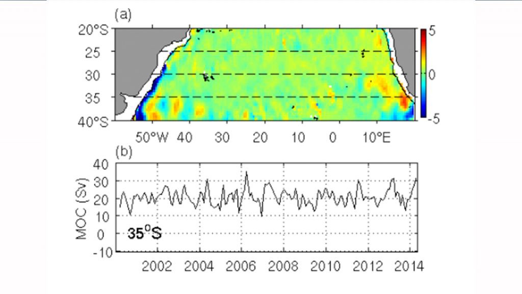
(a) Meridional volume transport in the upper 400m in the South Atlantic using Argo observations and satellite altimetry, the dotted lines mark the sections across 20°S, 25°S, 30°S, and 35°S where the strength of upper branch of the Meridional Overturning Circulation is estimated.
(b) Time series of the strength of the Meridional Overturning Circulation (MOC in Sv = 106 m3 s-1) at 35°S.
Click here to view the time series for the North Atlantic and South Atlantic.
The Benguela Current forms the eastern limb of the subtropical gyre in the South Atlantic and transports a blend of relatively fresh, cool Atlantic water and relatively warm, salty Indian Ocean water northwestward. Therefore, it plays an important role in the overall meridional heat and freshwater transport in the South Atlantic. A new three-dimensional data set of the horizontal velocity in the upper 2,000 m that covers the years 1993 to 2015 is used to analyze the Benguela Current’s variability. This data set was derived using observations from Argo floats, satellite sea surface height, and wind fields. The main features of the horizontal circulation observed in this data set are in good agreement with those from earlier studies based on limited observations. Therefore, it can be used for a more detailed study of the flow pattern, as well as variability in the circulation in this region. In terms of variability, this 23-year long time series at 30 and 35°S reveals phases with large energy densities at periods of 3 to 7 months, which can be attributed to the occurrence of Agulhas rings in this region.
![]()
Climatological transport in the upper 800 m based on Argo and altimetry.
(a) in the Brazil Current Region and (b) the Benguela Current Region. Red (blue) vectors indicate southward (northward) meridional transports. Shading in (b) indicates the magnitude of the transport.
Click here to view the time series for the Benguela Current and Brazil Current.
Core Argo
Core Argo is the temperature / salinity/ pressure operational mission that was the original goal the Argo Program. The basic mission of Argo is to track where heat and salinity are changing across the global ocean, down to a depth of 2,000 meters. The initial goal of the program called for the deployment of 3,000 profiling floats in a 3◦ x 3◦ array in the open ocean between 60◦N and 60◦S. This goal was met in November of 2007. The Argo Program has collected, processed, and distributed over two million vertical profiles of temperature and salinity from the upper ocean in the past two decades. The new array design, Argo2020, is global, full depth and multidisciplinary, and aims to contain 4,000 floats. The picture above shows an example of one core Argo float model. There are many different types of core Argo floats.
Deep Argo
Deep Argo aims to sample temperature and salinity over the full ocean depth up to 6,000 meters. The strength and variability of the large-scale ocean circulation that extends from the sea surface to the ocean bottom plays a significant role in the uptake and transport of heat and freshwater and the melting of sea ice. Since the inception of the Argo program, profiling floats have been limited to the top half of the sea (0-2,000m), and the accuracy of sensors has been similarly limited to upper ocean levels of temperature and salinity variability. The new generation of autonomous Deep Argo floats will sample the full ocean volume. This new array design, Argo2020, aims to deploy 1,200 Deep Argo floats. The picture above shows an example of one deep Argo float model. There are two deep Argo float models that dive to 6,000m depth and two models that dive to 4,000m depth.
BGC Argo
BGC-Argo aims at developing a global network of biogeochemical sensors on Argo profiling floats. Each float carries sensors to measure six core BGC-Argo variables: chlorophyll-a fluorescence, oxygen, nitrate, pH, and suspended particles, in addition to temperature, salinity, and pressure. These variables are the fundamental measurements that are required to address significant scientific and societal ocean/climate-related issues. The BGC-Argo network represents the most promising strategy for collecting temporally and spatially resolved observations of biogeochemical properties throughout the upper 2000 m of the ocean. The Argo2020 array design aims to contain 1,000 BGC-Argo. The picture above shows an example of one BG- Argo float model. Several core Argo floats also have BGC versions which carry dissolved oxygen sensors.
Printable Research Highlights


Ship of Opportunity Program Brochure

Credit: NOAA AOML
The Biogeochemical Argo (BGC-Argo) float array is a part of the internationally coordinated Argo network of robotic ocean profiling floats. BGC-Argo floats carry biological and chemical sensors that collect high-quality, multi-year ocean datasets from the sea surface to a depth of 2,000 meters. The addition of these sensors are expanding the existing Argo array that monitors ocean temperature and salinity. The growing global array of BGC-Argo floats are revolutionizing our ability to observe ocean biogeochemical cycles and understand ocean carbon uptake, acidification, deoxygenation, and marine ecosystem health.
NOAA’s AOML is deploying BGC-Argo floats in the chronically under-observed open Gulf of America, which is an important US fishery region. These floats will measure temperature, salinity, oxygen, nitrate, pH, chlorophyll-a fluorescence, and suspended particles across the upper 2,000 m of the Gulf water column. An initial array of four BGC-Argo floats was deployed in 2021 during NOAA’s fourth GOMECC cruise. Each battery operated BGC-Argo float returns ocean profile data via a satellite network in near-real time every ten days, equating to an estimated 250 total profiles per float over their 6.5 year lifespan. These new in situ observations will support research efforts on ocean acidification, seasonal hypoxia and interactions with freshwater influx, harmful algal bloom initiation, and impacts of extreme weather on ocean biogeochemistry. Our Gulf of America BGC-Argo floats will also provide validation data for regional models and satellite observations of the surface ocean as well as provide critical subsurface ocean data, supplementing scarce and seasonally-biased ship-based Gulf of America observations.

University of Washington Float1173 in Hawaii prior to deployment. The sensor on the left (blue top) is the Aanderaa oxygen optode, the sensor with the red ‘CTD’ label is the SBE63, and the sensor on the right (silver with a gray top) is the new SBE83 oxygen sensor.
ARGO US Data Assembly Center
AOML acts as the US Data Assembly Center (DAC) for the Argo program. The role of the DAC is to collect and quality control all of the Argo data collected by US scientific and governmental institutions. After the required quality for the data is achieved, it is transmitted to the two global data assembly centers (GDAC) in Brest, France and Monterey, California, who are the only two entities entitled to distributes Argo data to the world. The target is for these “real-time” data to be available within approximately 24 hours of their transmission from the float.
Operational Links for US DAC and US Argo Partners
Performance PlotsData Access for US Argo Principal Investigators- ftp://ftp.aoml.noaa.gov/phod/pub/ARGO_FTP/argo
AOML US DAC Monthly Reports
Argo Bibliography
Driving Innovative Science with Data.
Our Contribution to Global Ocean Observing.
This is a bibliography, originally published on Argo’s UCSD webpage, of papers published on Argo floats and their data. While this is an extensive list, papers in which Argo is a secondary source of data (model outputs and reanalyses, profile collection products, gridded products, etc.) are not all included here. Please send argo@ucsd.edu citations for Argo articles to keep this part of the bibliography updated.
Learn how to properly cite data from the Argo program.
View pdf list by year.
Featured Publication
Advancing ocean monitoring and knowledge for societal benefit: the urgency to expand Argo to OneArgo by 2030
Abstract: The ocean plays an essential role in regulating Earth’s climate, influencing weather conditions, providing sustenance for large populations, moderating anthropogenic climate change, encompassing massive biodiversity, and sustaining the global economy. Human activities are changing the oceans, stressing ocean health, threatening the critical services the ocean provides to society, with significant consequences for human well-being and safety, and economic prosperity. Effective and sustainable monitoring of the physical, biogeochemical state and ecosystem structure of the ocean, to enable climate adaptation, carbon management and sustainable marine resource management is urgently needed. The Argo program, a cornerstone of the Global Ocean Observing System (GOOS), has revolutionized ocean observation by providing real-time, freely accessible global temperature and salinity data of the upper 2,000m of the ocean (Core Argo) using cost-effective simple robotics. For the past 25 years, Argo data have underpinned many ocean, climate and weather forecasting services, playing a fundamental role in safeguarding goods and lives…..

Partners
Sharing Resources Delivers Results.
Expanding Reach Through Partnerships.

26
Countries
Participate in Argo’s international program, and NOAA is a leader among them. Through the Global Ocean Monitoring and Observing Program (GOMO), NOAA funds half of the international Argo Program.
Related Site Links
Together with partners around the world, the Argo program has deployed over 15,000 floats throughout the world’s oceans. While not a complete list of Argo partners, below is a list of key contributors:
International Programs
3
Million
The Argo Program has delivered 3 million temperature and salinity profiles in 25 years

Key Accomplishments
25 years of Argo observations! NOAA recently celebrated 25 years of Argo observations with an article entitled, ‘Argo, the ‘crown jewel’ of ocean observing systems, turns 25′ and featured four scientists in this piece.
2025
Argo collected its three-millionth profile in July 2024.
2024
Argo’s OneArgo proposal to expand from core Argo to a global, full depth, interdisciplinary array was endorsed as a project by the UN Ocean Decade. The OneArgo Project is attached to a UN Ocean Decade Program called “Observing Together: Meeting Stakeholder Needs and Making Every Observation Count”.
2021
The Argo program reached its two-decade mark. The program has deployed more than 15,000 floats and collected over 2 million temperature and salinity profiles.
2019
Argo collected its two-millionth profile in September 2018.
September 2018
Argo collected its one-millionth profile in October 2012.
October 2012
The goal of 3,000 active floats was reached in November of 2007.
November 2007
The first Argo float that used Iridium communication was deployed in 2005. Since then, Iridium has become the preferred means of satellite communication for Argo data.
2005
The first argo float was deployed.
1999
The Argo Science Team (later renamed the Argo Steering Team) was constituted at a joint meeting of the CLIVAR UOP and GODAE. The Argo Program was further endorsed as a pilot program by the Global Ocean Observing System (GOOS).
mid 1998
The “Argo Science Team” proposed a design for a global array of autonomous profiling floats to enhance the temperature and salinity measurements of the upper ocean.
1998