Hurricane Blog
This new study follows up on a recently-published study led by Michel Fischer that looked at the relationship between the tilt of tropical cyclone (TC) vortices and intensification. Both studies used a database of airborne tail Doppler radar (TDR) data collected by NOAA’s P-3 aircraft, spanning multiple decades, to examine the wind and rainfall structures of TCs and how they relate to […]
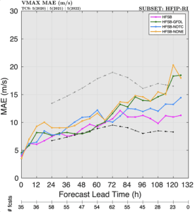
A new forecast model, the Hurricane Analysis and Forecast System (HAFS), was introduced during the 2023 hurricane season. We found that the cloud microphysics (how ice and water behave in clouds) had large impacts on track forecasts and some impacts on structure and intensity forecasts. The boundary layer physics had a notable impact on the […]
At the 75th annual Department of Commerce Awards Ceremony, Joe Cione earned a Gold Medal for Scientific/Engineering Achievement as part of the team that deployed the Altius drone into Hurricane Ian in 2022. The citation reads that the award was for “deploying a small uncrewed aircraft system into the eyewall of Hurricane Ian after a multi-year […]
This study uses a simple chaotic system to show that both model error and initial condition errors have profound impacts on predictability. These findings may have very important ramifications for how to design computer forecast models (and models in other fields where computer simulations are used) to improve their predictability. It is also shown for the first […]
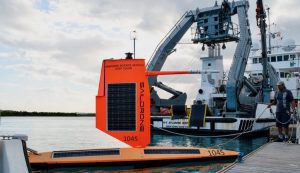
On September 30, 2021, a saildrone uncrewed surface vehicle made history by intercepting the eyewall of Hurricane Sam in the northwestern tropical Atlantic, recording a viral video of what it’s like to be tossed around by 100 mile-per-hour winds and 30-foot high waves. The Guinness Book of World Records later certified that a 126.4 mile-per-hour wind gust recorded […]
This research develops and tests a new approach of mass-flux parameterizations in high-wind-speed conditions like hurricanes. The better scheme has been implemented into NOAA’s Hurricane Analysis and Forecast System-B model to advance its skill in predicting TC structure and impacts such as storm surge and wind damage. The lowest 1-2 km of atmosphere (the planetary boundary layer […]
The story of the beginnings of aircraft reconnaissance of hurricanes has long been mythologized. The truth is more complex and interesting. The story of the first aircraft penetration of the eye of a hurricane by Lt. Colonel Joe Duckworth of the US Army Air Forces (USAAF) on 27 July, 1943, is told, but some myths have arisen concerning this event. There were previous attempts at hurricanereconnaissance, and a rival method (marine […]
This work explores the current state of the science of forecasts that provide a range of possibilities (i.e., probabilistic forecasts) of tropical cyclone (TC) genesis and track. Probabilistic TC forecast products can be an important resource for helping the public manage their level of risk from TC impacts. We examine experimental probabilistic genesis and track […]
Four Cooperative Institute for Marine and Atmospheric Studies employees were recognized on 5 December in a hybrid event held in Silver Spring for their leadership and for personal and professional excellence. Congratulations to Jason, Bill, Andy, and Sarah for their exceptional work to improve hurricane forecasts! For more information, contact aoml.communications@noaa.gov.


