
On March 8, 2014, Malaysian Airlines flight MH370 from Kuala Lumpur, the capital city of Malaysia, to Beijing, China went missing with 239 people aboard. The circumstances surrounding the aircraft’s disappearance led to various hypotheses to explain the event and to suggest the location of where the plane entered the water.
Satellite communications between flight MH370 and the Inmarsat satellite communication network were initially used to provide information about the approximate region where the aircraft might have entered the water. The last ping from flight MH370 to the Inmarsat satellite network delineated a part of the arc in the southeastern Indian Ocean where search activities have been conducted to date (without results).
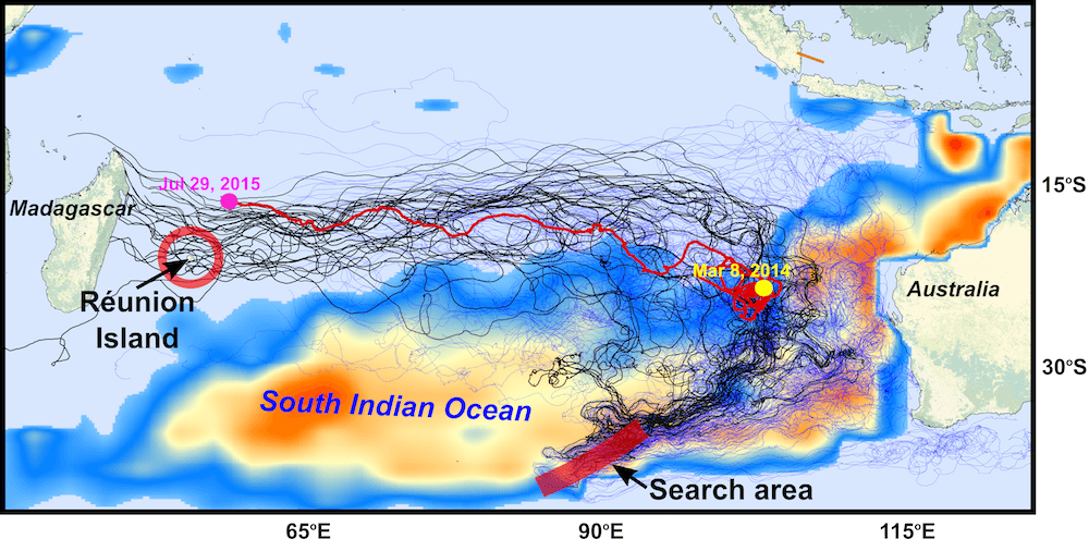
A significant event occurred at the end of July 2015 when a wing flaperon was discovered along the coast of Reunion Island in the western Indian Ocean. It was later confirmed that the flaperon was from flight MH370. The discovery of this piece of debris represented the first solid evidence that the aircraft might have crashed in the Indian Ocean. Other debris linked to the missing aircraft have also since been found in the western Indian Ocean.
In a paper published in the Journal of Operational Oceanography, a team of scientists with the Physical Oceanography Division at AOML, the University of Santiago de Compostela in Spain, the University of Miami, the University of Hawaii, and the Commonwealth Scientific and Industrial Research Organisation (CSIRO) of Australia analyzed possible pathways to link the location of the found debris in the southwestern Indian Ocean with potential crash sites, probably in the eastern Indian Ocean.
Image credit: NOAA
In this study, the research team used the aircraft debris that washed ashore along Reunion Island as a means of identifying potential sites for where flight MH370 could have crashed into the ocean. To accomplish this, they relied upon two main datasets routinely used to investigate the strength and variability of surface ocean currents.
The first dataset was of satellite-tracked surface drifter observations from NOAA’s Global Drifter Array, a component of the in situ global ocean observing system that relies on surface drifting buoys with a sea anchor (a drogue) centered at 15 m depth.
For the Indian Ocean, surface drifter observations began in 1985 and, on average, at any given time approximately 400 drifters provide surface current data on a continuous basis in this region. For the purposes of this study, however, only drifters that lost their drogue (undrogued drifters) were used, as they better simulated the characteristics and behavior of real debris.
The second critical dataset used in the study was the University of Hawaii’s Surface Currents from Diagnostic (SCUD) model of ocean currents, which incorpo- rates hydrographic, satellite altimetry, and wind data. In this model, thousands of synthetic particle drifters were deployed to analyze ocean currents, which was particularly important given the limited spatial and temporal coverage of the undrogued surface drifters.
The research team used both datasets to track the various pieces of aircraft debris backward in time. This allowed them to identify areas with a higher and lower probability of being the crash site. Simi- larly, a study of buoy trajectories forward in time revealed how the real and synthetic drifters moved away from the official search area, providing important information about the spatial and temporal distribution of potential debris.
Individual drifters with trajectories that traveled close to Reunion Island revealed that the official search area in the south- eastern Indian Ocean lies within an area of high probability as being the crash site. An analysis of the locations where aircraft debris was found, and from an analysis of surface currents derived from numerical model output and wind fields, also indicate that a large extension in the southeastern Indian Ocean south of 30ºS and along the east coast of Australia is potentially the most probable site of the crash of flight MH370.
Discoveries of debris linked to Malaysian Airlines flight MH370 that have washed ashore along the coasts of Mozambique, South Africa, Mauritius, and Tanzania are consistent with the results presented in the study and confirm the general westward drift and travel time of the debris from the search area. Results of this study also include the development and implementation of a new methodology that can be used to assess the source of marine debris, both for research and operational purposes.