Observational Instruments
Hurricane observational instruments allow scientists to collect real-time data that improves the accuracy of hurricane forecasts and provides critical information for weather prediction models.
SCROLL TO LEARN MORE
Researchers at the Atlantic Oceanographic and Meteorological Laboratory (AOML) employ an array of instruments to gather data from inside hurricanes. These instruments range from flying drones to deep-diving gliders, and are each uniquely designed to capture a previously inaccessible dataset. The data collected by these instruments are vital for enhancing forecasters’ understanding of a storm’s behavior, and improving hurricane prediction models, leading to better preparedness and response strategies.

Aircraft
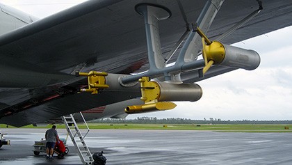
NOAA’s hurricane hunter aircraft are research stations with wings. The planes collect data using onboard instruments, as well as launch dropsondes, uncrewed systems, and other instruments into the storm. The P3-Orion flies directly into the storm, while the Gulfstream IV-SP flies overhead. The P3 flies back and forth across the eye, conducting multiple eyewall penetrations to gather data about wind speed, rain rate, and storm structure. The Gulfstream IV flies above the storm, collecting measurements from the atmosphere. The data gathered on these flights from both onboard and external instruments are crucial in improving hurricane forecasting, analysis, and modeling.
Uncrewed Surface Vehicles
Uncrewed Surface Vehicles (USVs) represent the intersection of atmospheric and oceanic observation instruments; their unique shape allows them to take measurements above and below the water. This data provides scientists with crucial information about the boundary layer where the ocean meets the atmosphere. During a hurricane, the sea surface within the boundary layer is subjected to strong winds and waves, making it inaccessible to crewed boats or planes. Saildrones, Oshen C-Stars, and other USVs can enter tropical cyclones to capture measurements of wind speed, wave action, air temperature, and temperature and salinity just below the ocean’s surface.
Understanding the boundary layer is important because it contains the conditions that will be experienced on the ground when a hurricane makes landfall. Accurate data from the boundary layer enhances storm impact predictions on coastal communities, enabling better preparedness and response efforts to protect lives and property.
Gliders
Gliders are autonomous underwater vehicles (AUVs) deployed during hurricane season to gather data to allow ocean conditions to be more accurately represented in hurricane forecast models. These observation instruments use small changes in buoyancy, along with wings for propulsion, to convert vertical motion into horizontal motion to swim and dive. This capability allows them to perform repetitive dives up to 1,000 meters deep, collecting temperature and salinity data.
Dropsondes
Dropsondes are the oldest hurricane observation instrument, and have been used since 1996. These instruments are launched from the bottom of the hurricane hunter aircraft to gather data inside the storm. After exiting the plane, a parachute deploys to slow its descent. As the dropsonde falls towards the ocean, sensors relay information about temperature, pressure, relative humidity, wind speed, wind direction, and dew point. In a given storm, researchers will release an average of 20-40 dropsondes along the flight track to gather real-time data at various points throughout the storm’s inner core and outer bands.

StreamSondes
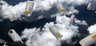
StreamSondes are a new addition to NOAA’s hurricane hunting kit. These ultra lightweight instruments developed by Skyfora are released from the hurricane hunter P-3 aircraft to gather atmospheric data. They are significantly lighter than dropsondes and scientists can deploy multiple sondes at a time, creating a “swarm” inside a tropical cyclone. Streamsondes report pressure, temperature, humidity, and wind data. The 2024 hurricane season marked the first year that Skyfora streamsondes were released operationally in high numbers, and scientists at AOML continue to work with Skyfora to improve the instrument design and software to maximize the high quality data available to researchers and forecasters.
Uncrewed Aircraft System (UAS)
Uncrewed Aircraft Systems (UAS), commonly known as drones, have improved hurricane research by giving scientists the ability to study the boundary layer where the atmosphere directly interacts with the ocean’s surface. UAS released from the NOAA P-3 aircraft stay aloft for hours at a time, collecting vital information on wind speed, humidity, temperature, and atmospheric pressure in the harshest conditions of a hurricane. This turbulent region influences the exchange of heat, moisture, and energy between the ocean and atmosphere. Understanding conditions within the boundary layer improves modeling efforts that forecast hurricane intensity and behavior.

Airborne Expendable BathyThermograph (AXBT)
Airborne Expendable BathyThermographs are another instrument launched from the belly of the hurricane hunter P3. This expendable does nothing until it hits the surface of the water, making it the only aircraft-deployed oceanic observation instrument. Once an AXBT hits the water, it measures ocean temperature as a function of depth. These observations give researchers an idea about how a storm passing overhead cools, mixes, or heats the ocean. AXBT data help scientists better understand the interactions between the ocean and the atmosphere during severe weather events. This information is crucial for improving hurricane intensity forecasts, as the thermal structure of the ocean significantly influences storm strength and development.
Argo Float
Argo floats drift with ocean currents and move up and down between the surface and mid-water level. These floats are distributed all over the global ocean and are in place year-round to measure temperature and salinity in the upper 2,000 meters. During hurricane season, these deep-diving instruments can be caught in storms, offering valuable data about ocean mixing beneath the cyclone. They can travel deeper than gliders, revealing the depths at which the ocean and atmosphere interact, crucial for understanding hurricane formation and development, as well as the impact hurricanes have on the ocean.


Drifters
Drifting surface buoys are tracked by satellites as they float through the ocean. They create a global network of data points that takes measurements year-round. Some observational buoys measure mixed layer currents, sea surface temperature, atmospheric pressure, winds, waves, and salinity. Since the drifters are floating year-round, they can be caught in the ocean below a hurricane if the current pulls them towards a developing storm. When this occurs, researchers seize the opportunity to explore an entirely new data set – the ocean conditions inside a hurricane.
Tail Doppler Radar (TDR)
The TDR system is located at the back end of the P-3 and G-IV aircraft. As the plane flies through a storm, the TDR continuously measures near-vertical cross-sections of precipitation and winds. By piecing together all of these cross-sections, scientists are then able to create a three-dimensional image of the storm. This three-dimensional “CAT scan” can show where the strongest winds are, how far the strong winds extend out from the storm center, and where the most intense rainfall occurs.


Multi-Mode Radar (MMR)
The MMR is located at the belly of the aircraft and features multiple modes available to the radar operator. For hurricane operations and research, the most relevant mode is the Hurricane Weather mode with turbulence identification. MMR uses the reflectivity from the surrounding environment get a signal back to the aircraft that provides researchers snapshots of the tropical cyclone structure.
Stepped-Frequency Microwave Radiometer (SFMR)
SFMR estimates surface wind speed and rain rate by measuring the surface brightness temperature directly below the aircraft. The brightness temperature of the ocean surface is related to the coverage of sea foam due to wave breaking, which increases as surface winds increase.


Cloud Microphysics
The Droplet Measurement Technologies, Inc. Cloud Combination Probe (CCP) includes 2 instruments, the Cloud Droplet Probe and the Cloud Imaging Probe, which measure particles at a wide range of sizes, providing two-dimensional images and precipitation size distributions. The Precipitation Imaging Probe and the Cloud and Aerosol Spectrometer measure hydrometeor sizes not seen by the CCP. These probes image cloud and precipitation particles to create particle-size distributions. All these data are used to study the precipitation composition and structure within the tropical cyclone and to improve the representation of cloud microphysics in numerical models.
Imaging Wind and Rain Profiler (IWRAP)
IWRAP, also known as the Advanced Wind and Rain Airborne Profile, measures the reflectivity velocity of precipitation, as well as ocean surface backscatter. These measurements are vital to understanding the low-level wind and precipitation structures of tropical cyclones that impact the earth’s surface.


Ka-band Interferometric Altimeter (KaIA)
KaIA is a next-generation radar altimeter that provides real-time observations of significant wave height of the ocean surface directly below the aircraft. KaIA can retrieve mean-squared surface slope, relative ocean height, and wind speed estimates at low wind speeds where other instruments are not as accurate.
Wide Swath Radar Altimeter (WSRA)
The ProSensing Inc. WSRA measures sea surface topography and rain rate. It offers real-time information on significant wave height, ocean directional wave spectra, the mean-square slope of the ocean surface, and rain rate. These data are critical to understanding ocean processes and storm surges.


Airborne Radio Occultation (ARO) System
The ARO system uses Global Navigation Satellite System signals, including GPS, to retrieve refractivity profile observations continuously during flight, typically providing 30-45 profiles over a 7-8 hour flight. ARO provides slanted profiles of temperature and moisture with 400 m vertical resolution roughly 400 km to the side of the flight track.