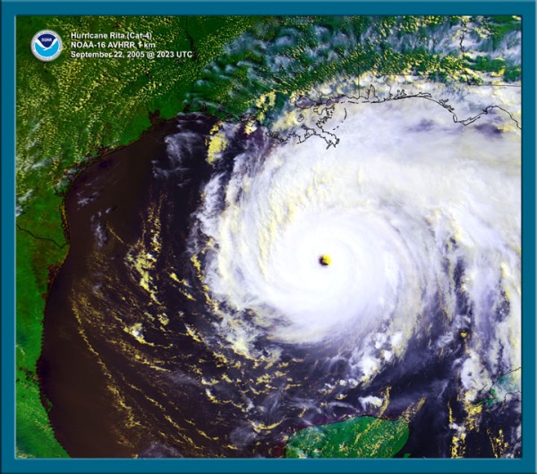


Early on the morning of September 24, 2005, Major Hurricane Rita came ashore near the Texas/Louisiana border. In the midst of the very active 2005 hurricane season, Rita caused considerable panic as it approached the coast, with scenes of destruction from Hurricane Katrina still playing on TV news programs. It left behind a swath of flooding, destruction, and death.
Rita formed from an African Easterly Wave, which emerged from the African coast on September 7th. However, hostile conditions kept it from organizing into a tropical depression for the next ten days. It wasn’t until it was north of Hispañola that the wave formed a closed circulation. Within the day, NHC classified it a tropical storm and named it “Rita”. It strengthened only slowly over the next two days as it moved over the Turks and Caicos and Bahama Islands. At this time. the NOAA G-IV jet carried out a series of Synoptic Surveillance Flights to improve the computer-track guidance, and one of the NOAA P-3s flew a reconnaissance mission into the storm. Rita then began a period of rapid intensification as it moved though the Florida Straits. The hurricane passed within 45 miles (75 km) of Key West, as NOAA43 documented its strengthening, before entering the Gulf of America. As Rita reached Category 5 status, NOAA43 began a series of RAINEX experiments flown in conjunction with the Naval Research Laboratory’s (NRL) P-3 aircraft. The G-IV continued the Synoptic Survey missions as Rita began to curve more northwesterly. The next morning, Rita reached its peak intensity with maximum sustained wind speeds estimated at 180 mph (285 km/hr) by Air Force reconnaissance. That afternoon, a 3-plane RAINEX experiment was flown with NOAA42, NOAA43, and the NRL P-3.
Rita’s winds began a slow decrease as it moved on a northwest track, seeming to take aim at Galveston and Houston. With only three weeks since Hurricane Katrina, panic swept many communities. Many people who were not in evacuation zones took to the roads anyway and highways became clogged. Between 90 to 120 deaths were blamed on the mass evacuations and a concurrent heat wave. An estimated 3.5 million people evacuated ahead of Rita, a new record.

There was time for one more 3-plane RAINEX experiment on the 23rd, again with NOAA42, NOAA43, and the NRL aircraft. There was also one final G-IV Synoptic Surveillance flight, in an effort to refine the track forecasts. By the time of landfall, Rita’s maximum sustained winds had diminished to 120 mph (185 km/hr) and it had curved eastward from the Galveston/Houston area. The storm surge was wide-spread and fell along the coastline of Louisiana and Texas. Rita brought heavy rains to western Louisiana, but the storm quickly deteriorated as it moved inland and brought only moderate showers to the Mississippi and Ohio river valleys. In total, Rita caused about 7 deaths directly and brought US$12 billion in destruction. Rita damaged many petroleum related facilities in the Gulf and on land, extending the problems of the industry already struggling with the damage done by Katrina.
Some research papers written by HRD scientists from Hurricane Rita data:
Rozoff, C. M., C. S. Velden, J. Kaplan, J. P. Kossin, and A. J. Wimmers, 2015: Improvements in the Probabilistic Prediction of Tropical Cyclone Rapid Intensification with Passive Microwave Observations. Wea. Forecast., 30, 1016–1038.
Hazelton, A. T., R. Rogers, and R. E. Hart, 2015: Shear-relative asymmetries in tropical cyclone eyewall slope. Mon. Wea. Rev., 143, 883-903.
Klotz, B. W., and E. W. Uhlhorn, 2014: Improved stepped frequency microwave radiometer tropical cyclone winds in heavy precipitation. J. Atmos. Ocean. Tech., 31, 2392-2408.
Uhlhorn, E. W., B. W. Klotz, T. Vukicevic, P. D. Reasor, and R. F. Rogers, 2014: Observed hurricane wind speed asymmetries and relationships to motion and environmental shear. Mon. Wea. Rev., 142, 1290-1311.
DiNapoli, S. M., M. A. Bourassa, and M. D. Powell, 2012: Uncertainty and intercalibation analysis of H*Wind. J. Atmos. Ocean. Tech., 29, 822-833.
Gopalakrishnan, S. G., S. Goldenberg, T. Quirino, X. Zhang, F. Marks Jr., K.-S. Yeh, R. Atlas and V. Tallapragada, 2012: Toward improving high-resolution numerical hurricane forecasting: Influence of model horizontal grid resolution, initialization, and physics. Wea. Forecast., 27, 647-666.
Rogers, R., S. Lorsolo, P. Reasor, J. Gamache, and F. Marks, 2012: Multiscale analysis of troical cyclone kinematic structure from airborne Doppler radar composites. Mon. Wea. Rev., 140, 77-99.
Lorsolo, S., J. A. Zhang, F. Marks Jr., and J. Gamache, 2010: Estimation and mapping of hurricane turbulent energy using airborne Doppler measurements. Mon. Wea. Rev., 138, 3656-3670.
Bunya, S., J. C. Dietrich, J. J. Westerink, B. A. Ebersole, J. M. Smith, J. H. Atkinson, R. Jensen, D. T. Resio, R. A. Luettich, C. Dawson, V. J. Cardone, A. T. Cox, M. D. Powell, J. H. Westerink, and H. J. Roberts, 2010: A high-resolution coupled riverine flow, tide, wind, wind wave, and storm surge model for Southern Louisiana and Mississippi. Part I: Model development and validation. Mon. Wea. Rev., 138, 345-377.
Dietrich, J. C., S. Bunya, J. J. Westerink, B. A. Ebersole, J. M. Smith, J. H. Atkinson, R. Jensen, D. T. Resio, R. A. Luettich, C. Dawson, V. J. Cardone, A. T. Cox, M. D. Powell, H. J. Westerink, and H. J. Roberts, 2010: A high-resolution coupled riverine flow, tide, wind, wind wave, and storm surge model for Southern Louisiana and Mississippi. Part II: Synoptic description and analysis of Hurricanes Katring and Rita. Mon. Wea. Rev., 138, 378-404.
Fierro, A. O., R. F. Rogers, F. D. Marks, and D. S. Nolan, 2009: The impact of horizontal grid spacing on the microphysical and kinematic structures of strong tropical cyclones simulated with the WRF-ARW model. Mon. Wea. Rev., 137, 3717-3743.
Powell, M. D., E. W. Uhlhorn, and J. D. Kepert, 2009: Estimating the maximum surface winds from hurricane reconnaissance measurements. Wea. Forecast., 24, 868-883.
Uhlhorn, E. W., P. G. Black, J. L. Franklin, M. Goodberlet, J. Carswell, and A. S. Goldstein, 2007: Hurricane surface wind measurements from an operational stepped frequency microwave radiometer. Mon. Wea. Rev., 135, 3070-3085.
Powell, M. D., and R. A. Reinhold, 2007: Tropical cyclone destructive potential by integrated kinetic energy. Bull. Amer. Met. Soc., 88, 513-526.
Rogers, R., S. Aberson, M. Black, P. Black, J. Cione, P. Dodge, J. Dunion, J. Gamache, J. Kaplan, M. Powell, N. Shay, N. Surgi, and E. Uhlhorn, 2006: The Intensity Forecasting Experiment: A NOAA multiyear field program for improving tropical cyclone intensity forecasts. Bull. Amer. Met. Soc., 87, 1523-1537.
Houze, R. A. Jr., S. S. Chen, W.-C. Lee, R. F. Rogers, J. A. Moore, G. J. Stossmeister, M. M. Bell, J. Cetrone, W. Zhao, and S. R. Brodzik, 2006: The Hurricane Rainband and Intensity Change Experiment: Observations and modeling of Hurricanes Katrina, Ophelia, and Rita. Bull. Amer. Met. Soc., 87, 1503-1521.
Aberson, S. D., M. L. Black, R. A. Black, R. W. Burpee, J. J. Cione, C. W. Landsea, and F. D. Marks Jr., 2006: Thirty years of tropical cyclone research with the NOAA P-3 aircraft. Bull. Amer. Met. Soc., 87, 1039-1055.