
South Florida Ecosystem Restoration
Monitoring the Physical, Chemical, and Biological Oceanography of South Florida’s Coastal Ecosystem
SCROLL TO LEARN MORE
Introduction
The South Florida Ecosystem Restoration research group has conducted regular interdisciplinary observations of the Gulf of America and south Florida coastal waters since the mid 1990’s, producing a comprehensive, long-term baseline for the regional circulation, salinity and water quality of the sensitive marine habitats found in these regions. These data are required to determine the natural system variability (spatially and temporally), and are a precursor to quantifying and assessing the impacts of more intermittent, extreme events which can affect the region such as hurricanes, harmful algal blooms and oil spills. The South Florida Program integrates data from environmentally and economically important areas, including three national parks (Biscayne, Everglades, and the Dry Tortugas) as well as the Florida Keys National Marine Sanctuary.
Additionally, the South Florida Ecosystem Research scientists have partnered with NOAA’s Southeast Fisheries Science Center to investigate how juvenile sportfish in Florida Bay respond to water quality and habitat. Samples of juvenile sportfish populations, along with water quality and seagrass measurements are taken in the Florida Bay. These measurements are used to examine the relationship between juvenile spotted seatrout abundance, salinity, temperature, and seagrass and to gain insights into the potential response of spotted seatrout to the Everglades restoration.
There are three current focus areas through which our team is monitoring the physical, chemical, and biological oceanography of South Florida’s coastal ecosystem: Regional Water Quality Assessment, Biscayne Bay Habitat Blueprint and Juvenile Sportfish Research in the Florida Bay.
Who We Are


Top News
NOAA cruises set the foundation for restoring crucial Florida ecosystems
March 28, 2025
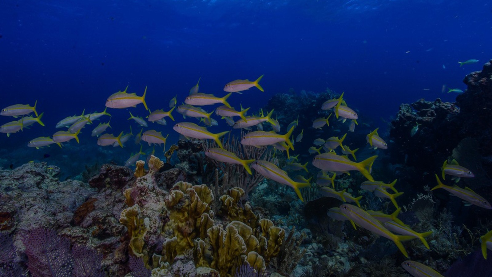
South Florida is comprised of 350 miles of the only barrier coral reef in North America – and the third largest in the world. 1,800 miles of shoreline is lined with mangroves in the Florida Keys alone, which provide coastal protection from storms and support juveniles of commercialized fish species. The region sustains the largest […]
Read More News
 100,000 cells per liter) are present in the water. K. brevis produces toxins called brevetoxins that can cause massive fish kills, weaken or kill marine mammals, and (if the toxin becomes aerosolized and inhaled) cause respiratory distress in humans and marine mammals. The team of scientists will be comprehensively sampling a series of transects along the West Florida Shelf." loading="lazy">
 100,000 cells per liter) are present in the water. K. brevis produces toxins called brevetoxins that can cause massive fish kills, weaken or kill marine mammals, and (if the toxin becomes aerosolized and inhaled) cause respiratory distress in humans and marine mammals. The team of scientists will be comprehensively sampling a series of transects along the West Florida Shelf." loading="lazy">
Increasing Red Tide Sampling off the West Florida Shelf
Red Tide Research
Since the mid 1990s, the South Florida Ecosystem Restoration scientists have been conducting bi-monthly regional survey cruises from stations located throughout south Florida’s coastal ecosystem from Miami through the Florida Keys up to Naples on board the University of Miami’s R/V F.G. Walton Smith. These cruises have been investigating coastal water quality in South Florida using discrete water sampling and flow-through measurements. Parameters collected at each station include dissolved inorganic nutrients, salinity, temperature, chlorophyll a, dissolved oxygen profiles, dissolved inorganic carbon, and fCO2. At specific sites, primary productivity, grazing rates, and zooplankton biomass are also measured. Through a partnership with the Marine Biodiversity Observing Network (MBON), led by the University of South Florida, samples of eDNA (environmental DNA) in the water column and near the benthic habitat are also being collected.
The R/V F.G. Walton Smith cruises have also been enhanced and modified to better capture the response of south Florida water quality to the red tide events which are occurring with increasing frequency in the southwest Florida shelf. On October 12– 19, 2018, AOML scientists led a multi-agency research cruise aboard the R/V F.G. Walton Smith to study the effects of southwest Florida’s on-going red tide. The cruise brought together a diverse team of experts from federal, state and academic institutions, as well as private industry.


Biscayne Bay Habitat Blueprint
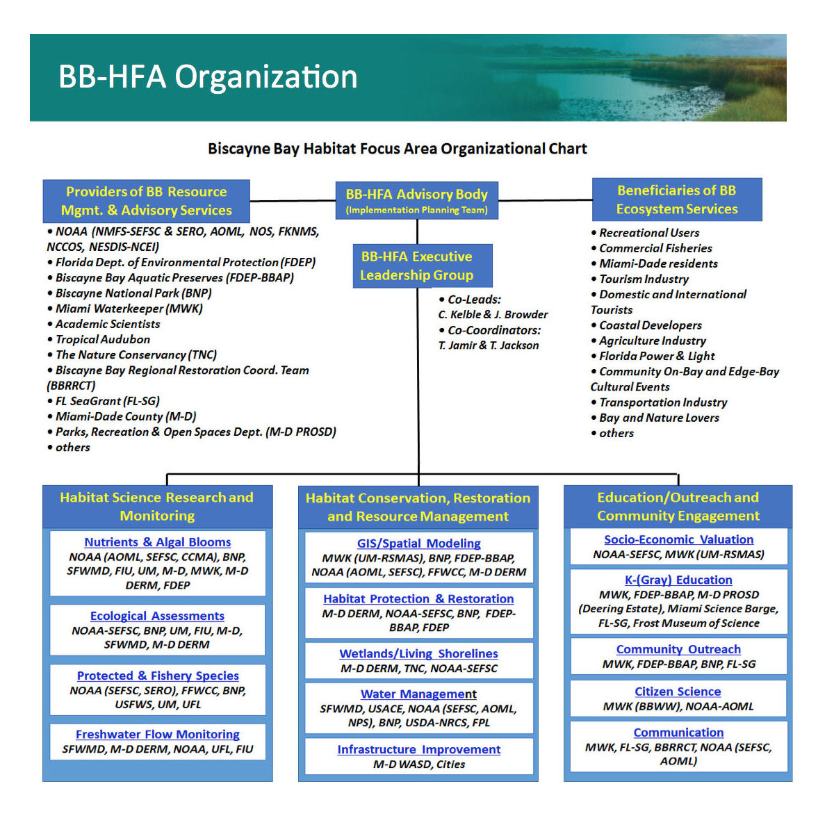
In 2011, the National Oceanic and Atmospheric Administration launched the NOAA Biscayne Bay Habitat Blueprint, a framework to address the growing challenge of integrating the Agency’s coastal and marine habitat conservation activities as part of a long-term effort to rebuild fisheries, recover threatened and endangered species, and support resilient coastal communities nationwide. In 2014, NOAA designated Biscayne Bay and its adjacent reef tract as the southeast region’s Habitat Focus Area.
The Biscayne Bay Habitat Focus Area developed an organizational structure, including an implementation team that was charged with developing a draft Biscayne Bay Habitat Focus Area implementation plan. The draft implementation plan focuses on achieving four habitat goals and their underlying objectives in Biscayne Bay as shown below.
Resource Management Partners
See below some educational resources for the Biscayne Bay Habitat Focus Area.
- Miami WaterKeeper
- Florida SeaGrant Biscayne Bay Waterwatch
- NOAA/Southeast Fisheries Science Center – Dolphin Monitoring
- NOAA/Atlantic Oceanographic and Meteorological Laboratory – Coastal Ecosystems Services in South Florida
- NOAA/Atlantic Oceanographic and Meteorological Laboratory – South Florida Water Quality Project
- NOAA Coral Reef Conservation Program
- Everglades Restoration
- Environmental Protection Agency
- Florida Fish and Wildlife Conservation Commission
- Florida Department of Agriculture and Consumer Services
- U.S. Army Corps of Engineers
- Biscayne National Park
- Biscayne Bay 2020 Status Report
- Biscayne Bay Regional Restoration and Coordination Team
- Biscayne Bay Digital Library
- Florida Department of Environmental Protection – Biscayne Bay Aquatic Preserve
- Florida Keys National Marine Sanctuary
- South Florida Water Management District
- South Florida Regional Council
- South Florida Ecosystem Restoration Task Force
- Miami-Dade County Environmental Resources Management
- U.S. Fish and Wildlife Service
Juvenille Sportfish Surveys
The saltwater recreational fishery adjacent to the Everglades generates approximately $880 million and greater than 6,000 jobs per year. This area includes Florida Bay, which not only supports a substantial recreational fishing industry within its waters, but also serves as a nursery ground for many of the adjacent commercial and recreational reef fishery species.
These commercial and recreational fishery species within Florida Bay will be affected by Everglades restoration as it works toward restoring the Florida Bay to a less disturbed state by minimizing hypersalinity. One of the best indicators for estuarine health is spotted seatrout. Spotted seatrout is a good indicator, because it spends its entire life within the bay it was spawned and is sensitive to fluctuations in water quality including salinity. Additionally, spotted seatrout is the second most commonly caught sportfish in Florida Bay, accounting for approximately 30% of all catch.
The South Florida Ecosystem Restoration scientists have partnered with NOAA’s Southeast Fisheries Science Center to investigate how juvenile sportfish in Florida Bay respond to water quality and habitat. Each year for six months, samples of juvenile sportfish populations, along with water quality and seagrass measurements are taken in the Florida Bay.
These measurements are used to examine the relationship between juvenile spotted seatrout abundance, salinity, temperature, and seagrass and to gain insights into the potential response of spotted seatrout to the Everglades restoration Visit our story map below to learn more.
Objectives
- Develop reference conditions that can be used as a baseline to evaluate trends in juvenile spotted seatrout populations and quantify the impacts of Everglades Restoration;
- Develop a juvenile abundance index (mean abundance and frequency of occurrence) and determine if annual differences in abundance occur among areas in the Bay;
- Examine the relationship between juvenile spotted seatrout abundance, salinity, temperature, and seagrass; use this analysis to gain insights into the potential response of spotted seatrout to the Comprehensive Everglades Restoration Plan; and
- Determine the salinity preference for other juvenile sportfish in Florida Bay.
South Florida Program
AOML scientists have conducted regular interdisciplinary observations of the south Florida coastal waters since the early 1990’s. Over the years, the AOML South Florida Program and its affiliated field operations, have enabled scientists and resource managers to keep a watchful eye on the sensitive marine habitats found in the region and have served as a sentinel during periods when the ecosystem has been subjected to extreme events such as hurricanes, harmful algal blooms, and potential oil spill contaminants. Additionally, the AOML South Florida Program has produced a comprehensive, long-term baseline for regional circulation, salinity, and water quality for the ecosystem. Sustained measurements that have been supported by the AOML South Florida Program include synoptic interdisciplinary bay-wide and regional shipboard surveys, a moored oceanographic instrument array, and Lagrangian surface drifter deployments.
The AOML South Florida Program integrates data from environmentally and economically important areas, including three national parks (Biscayne, Everglades, and the Dry Tortugas) as well as the Florida Keys National Marine Sanctuary. Economic activity associated with the Florida Keys National Marine Sanctuary alone contributed $4.4 billion and 43,000 jobs to the Florida economy in 2019.
Objectives
The AOML South Florida Program and associated efforts have yielded answers to important questions regarding the maintenance and welfare of the south Florida coastal marine ecosystem and have resulted in significant findings supporting the needs of resource managers such as:
-
- How can we mitigate hypersalinity in Florida Bay with a minimal input of additional freshwater? (Lee et al., 2008; Lee et al., 2016)
- How do we develop system-wide ecological indicators for use in reporting to congress and to the South Florida Ecosystem Restoration Task Force? ( Boyer et al., 2009)
- How do climate cycles and weather patterns affect hypersalinity in Florida Bay? (Kelble et al., 2007)
- What are the long-term trends in chlorophyll a for south Florida coastal waters? ( Brandt et al., 2014)
Sharing Resources Delivers Results.
Expanding Reach Through Partnerships.
18+
Partners working to help us deliver results to our stakeholders both within and outside of NOAA.
32
Research papers with non-NOAA authors

