
On 24 August, a tropical wave moved westward off the African coast, gradually becoming organized enough to become a tropical depression a week later almost 200 n mi east southeast of Barbados. Within 12 h, it became Tropical Storm Felix about 60 n mi south of Barbados. A period of rapid intensification commenced, and Felix became a hurricane only 24 h later, and as category-5 hurricane with 175 mph winds only 24 h after that. Felix eventually made landfall on 04 September near Punta Gorda, Nicaragua, as a category-5 hurricane with 160 mph winds. Felix caused extensive damage along the Mosquito coast and near Puerto Cabezas totaling nearly US$1 billion and led to 130 deaths in Nicaragua and 3 in Honduras.

NOAA conducted four research flights into Felix with the two P3 aircraft, mainly to collect Doppler radar data to test the assimilation of the data into the new HWRF model. During the third flight, radar imagery from the aircraft showed that Felix was a very small, but very intense hurricane, with a very intense eyewall. When the aircraft took off, NHC had just upgraded Felix to a category-2 hurricane that was undergoing rapid intensification.
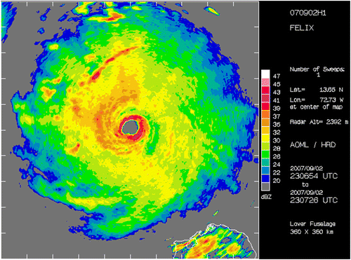
As the plane neared the eyewall, the wind speed at 10,000 feet increased to 186 mph, and the Stepped-Frequency Microwave Radiometer measured winds at the surface at an astounding 194 mph. At the same time, the plane encountered extreme turbulence, with winds moving downward at 22 mph quickly changing to upward at 69 mph. This caused the plane to rise nearly 300 m and then return to its original level within one minute. This marks the strongest vertical motion the aircraft has ever encountered in a tropical cyclone.

The story of this event was told in the paper
Aberson, S. D., J. A. Zhang, and K. Nuñez Ocasio, 2017: An extreme event in the eyewall of Hurricane Felix on 2 September 2007. Mon. Wea. Rev., 145, 2083-2092.
In addition to this, a number of other studies included data from Hurricane Felix:
DiNapoli, S. M., M. A. Bourassa, and M. D. Powell, 2012: Uncertainty and intercalibration analysis of H*Wind. J. Atmos. Ocean. Tech., 29, 822-833.
Dunion, J. P., C. D. Thorncroft, and C. S. Velden, 2014: The tropical cyclone diurnal cyclone of mature hurricanes. Mon. Wea. Rev., 142, 3900-3919.
Gopalakrishnan, S. G., S. Goldenberg, T. Quirino, X. Zhang, F. Marks Jr., K.-S. Yeh, R. Atlas, and V. Tallapragada, 2012: Toward improving high-resolution numerical hurricane forecasting: Influence of model horizontal grid resolution, initialization, and physics. Wea. Forecast., 27, 627-666.
Klotz, B. W., and E. W. Uhlhorn, 2014: Improved stepped frequency microwave radiometer tropical cyclone surface winds in heavy precipitation. J. Atmos. Ocean. Tech., 31, 2392-2408.
Martinez, J., M. M. Bell, J. L. Vigh, and R. F. Rogers, 2017: Examination of tropical cyclone structure and intensification with the Extended Flight Level Dataset (FLIGHT+) from 1999 to 2012. Mon. Wea. Rev., in press.