

In the middle atmosphere in and around tropical cyclones, around 2 to 5 km above the surface, air is cooler and drier than near the ocean surface. It is well known that this cool, dry air can be brought down toward the surface by heavy rain in thunderstorms, where the air flows toward the tropical cyclone center. If this cool, dry air gets close to the center (core), it can reduce the amount of thunderstorms in that area. Since these thunderstorms provide the energy for a tropical cyclone to strengthen, the cool, dry air in the core leads to weakening. However, the warm ocean below can make the cool, dry air warmer and moister, so the tropical cyclone may not weaken at all, and may even intensify. It is not currently known when the cool, dry air will enter the core and weaken the tropical cyclone, or when the air will become warmer and moister before this happens.

We studied how the cool, dry air moving downward influences tropical cyclone intensity using advanced computer models. The models showed many pockets of cool, dry air moving downward, and each of these were tracked as they moved around the tropical cyclone. We studied how each pocket of cool, dry air influenced the tropical cyclone. This is the first study to show how the location of the downward-moving, cool, dry air and the tropical cyclone’s structure determines its ultimate impact on how intense the tropical cyclone will be.
■ Important Conclusions:
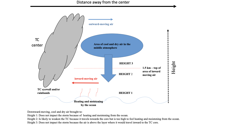
-The cool, dry air moving downward is most likely to weaken a tropical cyclone when it reaches to between 1 and 1.5 km altitude above the ocean (Height 2 in the figure) – the highest height that air moves toward the tropical cyclone core. Above this height, the air does not travel inward, so it cannot influence the tropical cyclone core (Height 3 in the figure). Nearer the surface (below Height 1 in the figure), the ocean always provides enough heat and moisture such that the air no longer is cool or dry, and it can no longer weaken the system.
-In developed tropical cyclones, the air is always coolest and driest between 2 and 5 km altitude (blue area in the figure). However, in the middle atmosphere of strong and compact hurricanes, there is less cool, dry air compared to broader and weaker tropical cyclones. This makes stronger and compact tropical cyclones more resistant to the negative impacts of downward moving cool, dry air. Thus, to further understand these processes, future studies should focus on weaker and larger tropical cyclones.
-Most previous research has focused on the area right above the sea surface where we found that the heat and moisture from the ocean always lessens the effects of the cool, dry air. This result will guide how future studies look at downward moving cool, dry air in tropical cyclones.
For more information, contact aoml.communications@noaa.gov.

The full article is available at https://journals.ametsoc.org/view/journals/atsc/aop/JAS-D-21-0006.1/JAS-D-21-0006.1.xml.
This work was completed while Joshua Wadler was gratefully supported by the National Science Foundation GraduateResearch Fellowship under Grant No. DGE-1451511. David Nolan was supported by the NASA Cloudsat/Calipso Scene Team Program under grant NNXW1GAP19G. Jun Zhang was supported by NSF Grant AGS1822128 and NOAA Grant NA19OAR4590239. Lynn Shay gratefully acknowledges support by the National Science Foundation under grant AGS 19-41498. Computational time was generously provided by the Institute for Data Science and Computing (IDSC) at the University of Miami.