
A new forecast model, the Hurricane Analysis and Forecast System (HAFS), was introduced during the 2023 hurricane season. We found that the cloud microphysics (how ice and water behave in clouds) had large impacts on track forecasts and some impacts on structure and intensity forecasts. The boundary layer physics had a notable impact on the forecasts of storm structure and rapid intensification. These results have helped us optimize HAFS for forecast improvement.

Two versions of the Hurricane Analysis and Forecast System (HAFS) were implemented operationally (meaning that it is used to inform official forecasts issued by the National Hurricane Center) during the 2023 hurricane season. The models make forecasts on a grid with points in and near the tropical cyclone (TC) about 2 km from each other. Smaller-scale processes like turbulence and cloud formation cannot be directly predicted on this grid, so forecast models use physics parameterizations, or approximations of these processes. Two key differences between the two versions of HAFS, called HAFS-A and HAFS-B, are the cloud microphysics (approximations of how the water in clouds changes between being solid (ice), liquid, and water vapor, and how the different particles behave, and the planetary boundary layer (PBL) physics, which approximate what happens in the the lowest 1-2 km of the atmosphere. Cloud microphysics are critical for approximating the effects of precipitation and the heating that drives the TC’s energy, and the PBL physics approximates a lot of the low-level flow and interactions with the warm ocean below that give TCs their energy. HAFS-B (but not HAFS-A) uses a version of the PBL physics that were specifically designed by AOML researchers to better approximate the extreme conditions inside the eyewalls of TCs. These changes were called “TC-PBL”.
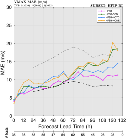
We performed several sensitivity experiments in which we ran the different versions of the model to see the impact of the different changes. The first set of runs (called HFSB-NONE) used the (Geophysical Fluid Dynamics Laboratory [GFDL] microphysics from the original versions of HAFS, and the PBL scheme without the TC-PBL options. The second set of runs was close to the operational HAFS-B and used complex, computationally expensive microphysics (Thompson microphysics), along with the TC-PBL options (HFSB). Two other experiments used Thompson microphysics but no TC-PBL (HFSB-NOTC), and TC-PBL with the GFDL microphysics (HFSB-GFDL).

Conclusions:
- The runs using the TC-PBL scheme produced better forecasts of rapid intensification (when a storm intensifies by at least 30 knots in 24 hours) and better forecasts of storm intensity overall than the other versions without the TC-PBL scheme (Fig. 1).
- The Thompson microphysics scheme improved the intensity forecasts and led to fewer forecasts of rapid intensification that did not actually happen.
- TC-PBL leads to stronger flow of warm, moist air near the surface toward the TC center, and convection and precipitation focused more in the eyewall region allowing for forecasts of stronger TCs and improved forecasts.
- All experiments produced TCs that were too small and with wind away from the center that was too weak) compared to data from NOAA Hurricane Hunter aircraft (Fig. 2). This tells us that we still have work to do to improve the overall TC structure.

For more information, contact aoml.communications@noaa.gov. The paper can be found at https://doi.org/10.1175/WAF-D-23-0124.1. Lead author Andrew Hazelton was supported by NOAA grants NA19OAR0220187 and NA22OAR4050668D. The GRaphics for OS(s)Es and Other modeling applications on TCs (GROOT) verification package developed by Dr. Sarah Ditchek and funded by the Quantitative Observing System Assessment Program (QOSAP) and the FY18 Hurricane Supplemental (NOAA Award ID #NA19OAR0220188) was used to generate graphics for this publication. This research was carried out in part under the auspices of the Cooperative Institute for Marine and Atmospheric Studies, a cooperative institute of the University of Miami and the National Oceanic and Atmospheric Administration (NOAA), cooperative agreement NA20OAR4320472.