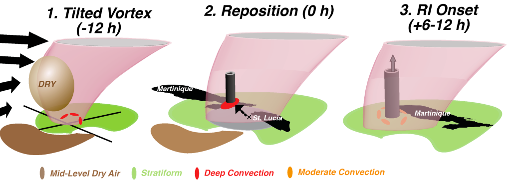
This study showed that a weak, disorganized tropical system in an environment that is not primed for intensification can develop a new center where conditions are more favorable for intensification. The ability to observe the center of circulation, the tilt of the vortex with height, the depth of the vortex, the wind shear, and locations of dry air regularly in time is important in being able to diagnose these unpredictable events and improve forecasts.

Summary: Hurricane Dorian unexpectedly intensified from a weak, disorganized tropical storm into a hurricane as it was moving through the Lesser Antilles. Previous studies have shown that if a tropical cyclone has centers at different vertical levels in the same locations, has precipitation completely surrounding the center, and a humid environment, it is likely to intensify. A change in wind speed and direction with height (wind shear) can push the circulation center toward different places with height, and we call this a tilted vortex (panel 1 in the figure), and this usually limits intensification. Data from Météo-France ground radars in Martinique and Guadeloupe, Air Force reconnaissance aircraft, and NOAA P-3 Tail Doppler Radars reveal important details to help better understand how Dorian intensified from the time it had a tilted vortex and its interactions with dry air in the surrounding environment.

In panel 1, wind shear initially pushes drier air near the circulation, moves centers towards different places with height, and displaces the strongest thunderstorms (deep convection) to one side of the storm. Wind shear decreases by panel 2, however, the centers of circulation were still at different locations with height. By this time the circulation (represented by the pink) expanded and interacted with Martinique, reaching the island’s mountains and moving upward. This increased upward motion caused very strong thunderstorms to form along with a new small circulation (represented by the black/grey cylinder). This new circulation, favorably located in the moist region, developed upward and intensified as new thunderstorms (moderate convection) developed around it.
Important Conclusions:
-Initially, Dorian struggled to intensify due to dry air near the circulation and a tilted vortex despite a decrease in wind shear (panels 1 and 2).
-After Dorian’s center interacted with Martinique’s landmass, strong thunderstorms developed, and a new circulation center formed in a more favorable, humid environment (and intensification began, panels 2 and 3).
-Intensification of the newly formed center occurred despite some difference in center locations with height. This shows that perfect vertical alignment of the centers is not necessary for TC rapid intensification if the surrounding environment is favorable and the tilt is not very large.

For more information, contact aoml.communications@noaa.gov. The manuscript can be found at https://journals.ametsoc.org/view/journals/mwre/150/1/MWR-D-21-0069.1.xml.