
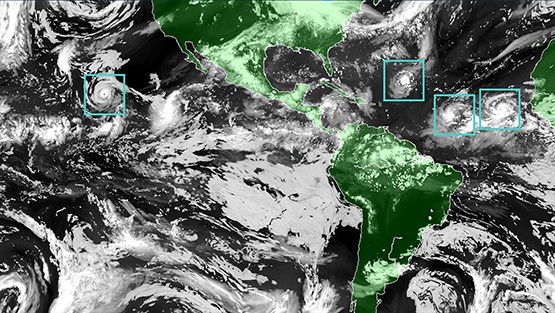
basins. The blue boxes represent high-resolution grids surrounding each
tropical cyclone in the new version of HWRF.
Summary:
NOAA’s operational Hurricane Weather Research and Forecasting Model (HWRF) has become an important tool for both hurricane forecasters and researchers. HWRF has three domains around only one tropical cyclone; each domain has grids closer together than the one outside it (what we call high resolution) to allow the model to see small features that are important to forecasts.
However, there is usually more than one tropical cyclone at a time in the Atlantic and eastern Pacific basins, and they can affect each other even if they are far apart. HWRF cannot accurately forecast these effects, but the Basin-Scale HWRF (HWRF-B – https://noaahrd.wordpress.com/2017/06/06/paper-on-the-new-basin-scale-version-of-hwrf-developed-at-hrd-released-online-in-weather-and-forecasting/) allows for forecasts of more than one tropical cyclone at the same time, so these effects can be captured.
This study introduces a new and improved version of HWRF-B that allows for the high-resolution grids to surround all the tropical cyclones instead of just one. One of the biggest differences with the older version of HWRF-B is in what we call “coupling” of the ocean and the atmospheric parts of the model.
The warm ocean is where the energy for hurricanes comes from, so good hurricane forecasts depend on knowing what is happening in the ocean. Not only do hurricanes take heat from the ocean, but the wind also roils the water, mixing the warm water at the surface with cooler water below. This lowers the amount of energy available to the hurricane. However, putting all these processes (coupling) into our forecast models is very difficult. A new way to forecast these processes is created and put into HWRF-B, so that the model was now coupled for more than one tropical cyclone. This new coupling can be used in any forecast model, and is a large step toward the next generation of hurricane models currently being developed at NOAA.
Realtime forecasts from this system can be viewed at https://storm.aoml.noaa.gov/viewer.
Important Conclusions:
- This new version of HWRF improved forecasts of where the storm is going (called track forecasts) by up to 25%.
- The new version also improved forecasts of how intense the storm will be (called intensity forecasts) by up to 40%.
- Forecasts with multiple storms had median errors that were up to 30% smaller than forecasts with a single storm.

You can read the paper at https://www.mdpi.com/2073-4433/11/8/869.
For more information, contact aoml.communications@noaa.gov.