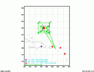
At about 1400 UTC (10AM Eastern), NOAA’s three large aircraft (G-IV, and 2 P3s: NOAA42 and NOAA43) will take off from St. Croix to fly a coordinated experiment in the remnants of Gabrielle. The goal of these missions is to collect meteorological and oceanic data to evaluate numerical models, especially HWRF.
The above is the G-IV flight track is a square spiral. The numbers on the figure show the dropwindsonde launch locations.
The NOAA42 flight track is above. The numbers on this figure show the turn points the aircraft will make. The red and purple dots represent locations where weather balloons are launched daily.
NOAA43 will fly an inner-core pattern to gather Tail Doppler Radar data as outlined in our experiment plan.

