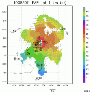


As Earl continues intensification to a major hurricane and passes just north of Puerto Rico (visible outlined in black at the bottom left of the images) NOAA P-3 missions continue to collect airborne Doppler radar data to use in initializing and evaluating model guidance. Included here you will see images of the horizontal winds within the inner core of Hurricane Earl sampled from the tail Doppler radar on the P-3 late on 30 August 2010. Wind, temperature and relative humidity from GPS dropsondes dropped from the P-3 are also visible at 1 km altitude. These images are at three altitudes, 1km, 5km, and 10km, using a composite of winds from all three legs oriented southeast-northwest, southwest-northeast, and north-south. Note the strongest winds on the northeast side of the storm at all altitudes up to 10 km. Compared to the analyses in the first three P-3 missions there is little tilt apparent in the center of the circulation from 1 km to 10 km altitude, suggesting that Earl is encountering much less vertical shear of the horizontal wind over the vortex. The radius of the maximum wind continues to contract over the past few analyses.