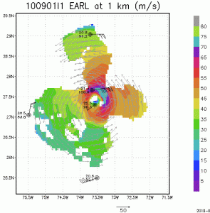


As Earl starts to track more in a more northerly direction and intensifying again as it passes just east of the Bahamas NOAA P-3 missions continue to collect airborne Doppler radar data to use in initializing and evaluating model guidance. Included here you will see images of the horizontal winds within the inner core of Hurricane Earl sampled from the tail Doppler radar on the P-3 late on 1 September 2010. Wind, temperature and relative humidity from GPS dropsondes dropped from the P-3 are also visible at 1 km altitude. These images are at three altitudes, 1km, 5km, and 10km, using a composite of winds from two legs oriented east-west and south-north. Note the strongest winds on the northeast side of the storm at 1 km altitude, rotating clockwise in azimuth with increasing altitude until it is east of the center at 10 km. This clockwise rotation of the wind maximum with increasing altitude is similar to that in the previous missions analysis, suggesting that Earl is encountering vertical shear of the horizontal wind over the vortex from the increasing westerlies aloft impacting the storm as it moves north. The major difference between this analysis and the previous one is that the peak winds are much higher reflecting the increase in intensity, suggesting an easing of the vertical wind shear. Other changes evident are a much broader wind maximum and a slight decrease in the radius of the maximum wind over that in the past analyses, also indicative of intensification.