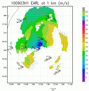


As Earl continues to accelerate northward and weaken as it approaches the Delmarva Peninsula (depicted by the black line in the upper left of the images) NOAA P-3 missions continue to collect airborne Doppler radar data to use in initializing and evaluating model guidance. Included here you will see images of the horizontal winds within the inner core of Hurricane Earl sampled from the tail Doppler radar on the P-3 early on 3 September 2010. These images are at three altitudes, 1km, 5km, and 10km, using a composite of winds from four legs oriented southwest-northeast, northwest-southeast, east-west, and south-north. Wind, temperature and relative humidity from GPS dropsondes dropped from the P-3 are also visible at 1 km altitude. Unlike the previous missions the strongest winds are located on the east-souteast side of the storm at 1 km altitude, rotating only slightly clockwise in azimuth with increasing altitude until it is southeast of the center at 5 km. It is hard to tell what azimuth the peak winds are at 10 km because of the lack of scatterers at that altitude, indicative of weakening convection to loft precipitation to that altitude. This clockwise rotation of the wind maximum with increasing altitude is similar to that in the three previous missions analyses, suggesting that Earl is encountering vertical shear of the horizontal wind over the vortex from the increasing westerlies aloft impacting the storm as it moves further northward. The major difference between this analysis and the previous few is that the peak winds are weaker and a pretty dramatic increase in radius of the maximum wind, suggesting Earl is weakening rapidly as the vertical wind shear over the center continues and the storm starts to accelerate. Other changes evident are a much more asymmetric wind field with stronger winds on the southeast side of the storm. These changes suggest the storm is weakening rapidly.