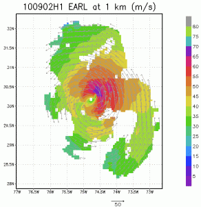


As Earl starts to accelerate northward and begins weakening as it passes just east of the Florida NOAA P-3 missions continue to collect airborne Doppler radar data to use in initializing and evaluating model guidance. Included here you will see images of the horizontal winds within the inner core of Hurricane Earl sampled from the tail Doppler radar on the P-3 early on 2 September 2010. These images are at three altitudes, 1km, 5km, and 10km, using a composite of winds from three legs oriented southwest-northeast, northwest-southeast, and east-west. As in the two previous missions the strongest winds are located on the northeast side of the storm at 1 km altitude, rotating clockwise in azimuth with increasing altitude until it is east of the center at 10 km. This clockwise rotation of the wind maximum with increasing altitude is similar to that in the two previous missions analyses, suggesting that Earl is encountering vertical shear of the horizontal wind over the vortex from the increasing westerlies aloft impacting the storm as it moves north. The major difference between this analysis and the previous one is that the peak winds are much weaker suggesting Earl is weakening as the vertical wind shear over the center increases. Other changes evident are a much more asymmetric wind field with stronger winds on the east side of the storm and a slight decrease in the radius of the maximum wind over that in the past analyses. These changes suggest that while the peak winds are decreasing the wind field is more asymmetric projecting more of the structure on to wavenumber 1.