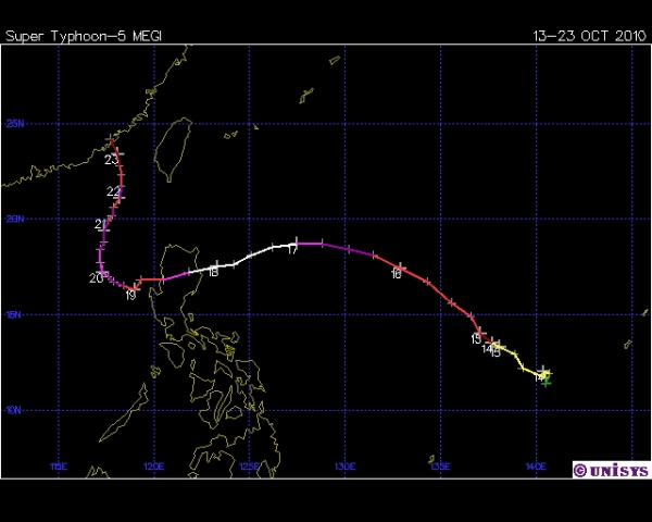
Just before local Noon of October 18, 2010, Super Typhoon Megi struck the Philippine Islands, causing substantial damage to the main island of Luzon.
Megi developed from a depression which formed on Oct. 10th near Guam. As the storm began to move slowly northwestward, favorable conditions allowed it to organize and reach typhoon strength by Oct. 15th. Because the Impact of Typhoons on the Ocean in the Pacific study (ITOP) was ongoing in 2010, Air Force Hurricane Hunter aircraft were available to monitor the developing storm. They flew eight sorties into Megi from formation until landfall on Luzon.

As its forward speed increased, Megi began to rapidly intensify and reach Super Typhoon status by Oct. 17th. By then its track had curved westward and was headed toward the Philippines. The Philippine government, which designated the storm as Super Typhoon Juan from their separate name list, issued warnings for Luzon, urging farmers to bring in their crops and for residents of coastal areas to evacuate. Within 36 hours, Megi had turned slightly south of due west and struck northern Luzon with maximum sustained winds of 145 mph (230 km/hr). The typhoon weakened as it passed over the island, but began to strengthen again once it reached the South China Sea.
The Super Typhoon then turned north, and began a slow approach to Taiwan and Mainland China. While it produced heavy rains on both Chinas, it weakened substantially before making landfall on Zhangpu, China, with maximum sustained winds were 80 mph (130 km/hr). It dissipated quickly as it moved over the mountains inland. Due to the early warnings and Hurricane Hunter monitoring, the death toll was low relative to previous typhoons hitting Luzon with just over 60 dead. But the economic damage still exceeded US$700 million.
Paper written by an HRD scientist using data from Megi:
Wu, C.-D. K.-H. Chou, P.-H. Lin, S. D. Aberson, M. S. Peng, and T. Nakazawa, 2007: The Impact of Dropwindsonde Data on Typhoon Track Forecasts in DOTSTAR. Wea. Forecasting, 22, 1157–1176.