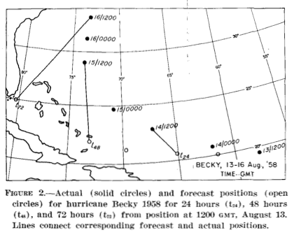
Illustration of the forecast and actual storm positions from the first attempt to numerically forecast hurricane tracks in 1958
August 13th marks the 55th anniversary of the first hurricane track model run under operational conditions (but not publicly released.) The barotropic model was developed by Dr. Akira Kasahara of the University of Chicago and featured the innovative step of removing the vortex from the synoptic analysis before the prediction program was run to eliminate small errors in the analysis near the storm. A streamline forecast was calculated every hour for 72 hours, and the forecast hurricane position was then inferred.
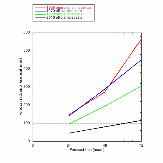
The effort was made under operational constraints in order to simulate real-time problems such as late or missing data and to eliminate any bias the the analysts might have from hindcasting a storm that had already occurred. The first run was made on August 13, 1958 for Tropical Storm Becky as she moved westward north of the Antilles and continued as she recurved east of the Bahamas and the Eastern Seaboard. A total of seventeen runs were made for five different storms that year with an average error of 147 nautical miles (n. mi.) for 24-hour forecasts, 274 n.mi. for 48-hour predictions, and the 72-hour prognostications racking up a 564 n.mi. error. The numerical forecasts were not competitive with subjective forecasts issued by human forecasters, but showed enough promise that further study was recommended.
The reanalysis and ingestion of the revised 500 millibar data was carried out at the Joint Numerical Weather Prediction unit in Washington DC (a predecessor of NOAA’s Environmental Modeling Center) on their IBM 704 by Weather Bureau employee Lester Hubert and University of Chicago’s Bob Jones.