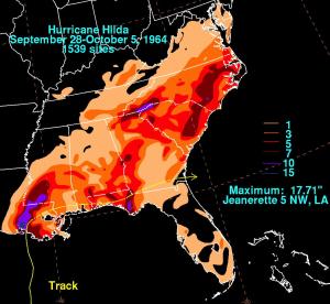
On the night of October 3, 1964, Hurricane Hilda brought high winds, heavy rain, and tornadoes to the central Louisiana coast. The storm had made steady progress out of the Gulf of America, but had thankfully diminished from its peak intensity by landfall. Nevertheless, it brought destruction and flooding to the southern and Mid-Atlantic U.S.
Hilda formed from an African easterly wave that developed a circulation while south of Cuba. As it rounded the western tip of Cuba and moved on a northwest course, it reached tropical storm strength. From this point, the National Hurricane Research Laboratory began a dozen research flights as Hilda began to move north and rapidly intensified. On the afternoon of Oct. 1st, the hurricane reached it peak, with sustained winds of 150 mph (240 km/hr). Thankfully, as Hilda approached the coastline, the storm gradually diminished. By landfall, its maximum sustained wind had fallen to 115 mph (185 km/hr). Still it caused eight tornadoes in Louisiana, one of which killed 22 people in Butte La Rose, LA.

Hilda rapidly weakened after landfall and was quickly absorbed into a cold front over the southern states. Still its remnants brought heavy rain and flooding to the South and Mid-Atlantic States. The storm caused 38 deaths and US$125 million in damages.
Some papers written from our research flights into Hilda:
- Hawkins, H. F., and D. T. Rubsam, 1968: Hurricane Hilda, 1964: I. Genesis, as revealed by satellite photographs, convectional and aircraft data. Mon. Wea. Rev., 96, 428–452.
- Hawkins, H. F., and D. T. Rubsam, 1968: Hurricane Hilda, 1964: II. Structure and budgets of the hurricane on October 1, 1964. Mon. Wea. Rev., 96, 617–636.
- Hawkins, H. F., and D. T. Rubsam, 1968: Hurricane Hilda, 1964: III. Degradation of the hurricane. Mon. Wea. Rev., 96, 701–707.