

On August 27, 1964, Hurricane Cleo smashed its way along the east coast of Florida, bringing considerable damage from Key Biscayne to Jacksonville. During the previous week, the storm had rampaged through the Lesser and Greater Antilles, leaving over 150 dead and nearly US$60 million in damage. It had reached its peak with 155 mph (250 km/hr) winds while south of Hispañola. But encounters with that island and Cuba weakened Cleo to tropical-storm strength. While moving north of Cuba over the Gulf Stream, Cleo regained hurricane strength. The hurricane was monitored constantly by Research Flight Facility aircraft, which found no wind of hurricane strength on the western side of the storm. However, the last DC-6 penetration was 3 hours prior to landfall, during which time the hurricane unexpectedly rapidly intensified to 100 mph (160 km/hr). In Florida, Cleo smashed the windows of hotels and storefronts along Miami Beach, destroyed the theme park Storyland in Pompano Beach, delayed the opening of Florida Atlantic University in Boca Raton, and uprooted trees and downed power lines all the way to Melbourne. Most of the damage was confined to a narrow 30 mile strip along the coast, but that’s where most of the expensive properties were located. After exiting the coast at Jacksonville, Cleo struck Savannah and brought heavy rains to Georgia, the Carolinas, and Virginia, as well as tornadoes to South Carolina. Cleo’s U.S. rampage cost 2 lives and nearly US$130 million in damage.

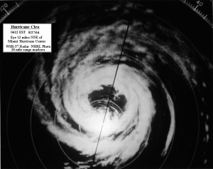
Cleo’s track from Miami radar
The eye of Hurricane Cleo passed over the Aviation Building (near Miami International Airport) which then housed both the National Hurricane Center and the National Hurricane Research Laboratory. Meteorologists in the building were able to observe lightning in the eyewall as it passed over.