
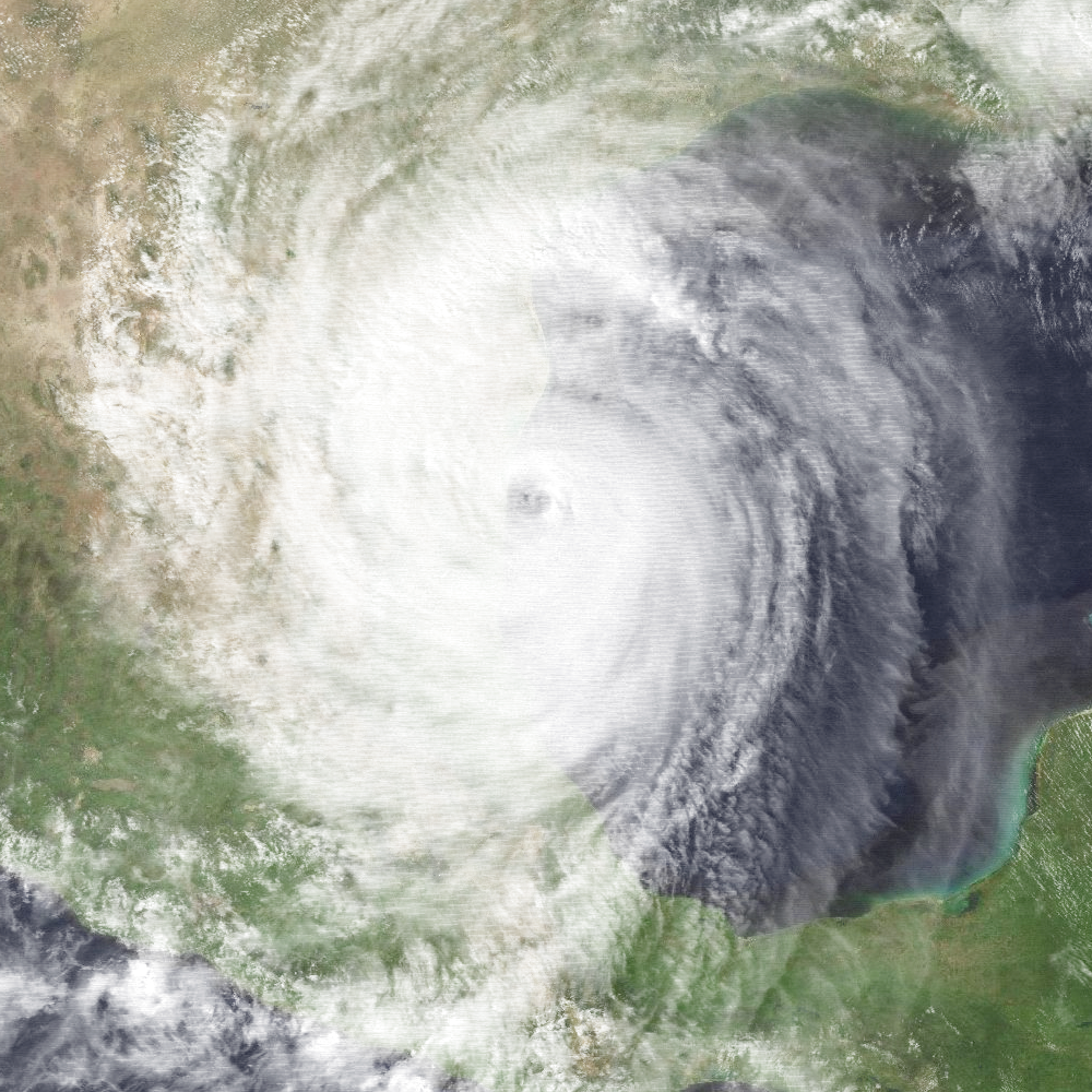
On September 16, 1988, Hurricane Gilbert made landfall at the Mexican city of La Pesca,Tamaulipas, with winds of 125 mph (200 km/hr). It had already brought destruction upon the Yucatan peninsula and the Caribbean islands. Along the way it set a new low-pressure record that would stand for 17 years.
Gilbert was a classic Cape Verde hurricane. It grew from a African easterly wave that moved off the African west coast on Sept. 3rd. It moved steadily westward but did not organize a circulation until 5 days later. By the time it reached the Leeward Islands it was a Tropical Storm and given the name Gilbert. As it passed over the islands it dumped heavy rains that brought mudslides and ruined crops. It began to rapidly intensify as it moved south of the Greater Antilles throwing heavy rainbands into Hispañola. It reached Category-3 status by the time it made landfall on Jamaica.
The hurricane brought a 19-ft (6-m) storm surge to the eastern shore of Jamaica and brought tropical downpours and high winds to the entire island. It left 49 dead, destroyed 100,000 homes, and caused US$700 million in damages (70% of that agricultural losses).
Jamaica knocked down Gilbert’s maximum sustained winds, but the storm quickly recovered and even began another period of rapid intensification. Within a day, it had become a roaring Category-5 monster with winds of 185 mph (295 km/hr), brushing south of Grand Cayman and barrelling toward the Yucatan. At this point, a NOAA research flight was dispatched into Hurricane Gilbert.

HRD had been carrying out a series of back-to-back Long-term Monitoring experiments on the storm since it was south of Hispañola, but this flight found Gilbert at its peak intensity. A record-low central pressure for Atlantic hurricanes of 888 mb was estimated from flight level. This broke the previous record of 892 mb for the Labor Day hurricane of 1935 and stood until Hurricanes Rita and then Wilma in 2005.

There was considerable controversy surrounding the pressure value since there were no dropsondes available on this mission with which to directly measure the surface pressure. Therefore the value was extrapolated from flight level and this method initially gave a value of 879 mb. Later recalculation using better assumptions about the temperature profile of the eye resulted in the official 888-mb value. For more information on this see :
H. E. Willoughby, J. M. Masters, C. W. Landsea, Mon. Wea. Rev., 117, 2824-2828.

When Gilbert hit the Yúcatan Peninsula, it pushed s storm surge 5 km (3 mi) inland, brought over 10″ (250 mm) of rain to the peninsula, and did billions of dollars (1988 US$) in damage. It left the area’s tourism infrastructure in tatters for the rest of year. It also brought torrential rains to northern Central America, leaving scores of people dead, thousands homeless, and crops in ruins.
The trip over the Yucatan did reduce Gilbert down to Category-3 level, but the warm waters of the Gulf of America allowed it to regain some of its strength before hitting the Mexican state of Tamaulipas. Northern Mexico suffered heavy rains, mudslides, and flash floods. Mexico’s third largest city, Monterrey, was left without power or water for days.
The storm remnants recurved over northern Mexico and deposited heavy rains over Texas and the Mississippi river valley. During its life cycle, Gilbert caused 318 deaths and nearly US$3 billion in damages.
Besides being a record storm, the flights into Gilbert provided researchers with a deeper understanding of storm dynamics of major hurricanes and the importance of air-sea interactions.
References
Barnes, G. M., and M. D. Powell, 1995: Evolution of the inflow boundary layer of Hurricane Gilbert (1988). Mon. Wea. Rev., 123, 2348-2368.
Black, M. L., R. W. Burpee, and F. D. Marks Jr., 1996: Vertical motion characteristics of tropical cyclones determined with airborne Doppler radial velocities. J. Atmos. Sci., 53, 1887-1909.
Black, M. L., and H. E. Willoughby, 1992: The concentric eyewall cycle of Hurricane Gilbert. Mon. Wea. Rev., 120, 947-957.
Dodge, P. P., R. W. Burpee, and F. D. Marks (1999), The kinematic structure of a hurricane with sea level pressure less than 900 mb. Mon. Wea. Rev., 127, 987-1004. doi:10.1175/1520-0493(1999)127%3C0987:TKSOAH%3E2.0.CO;2.
Eastin, M. D., P. G. Black, and W. M. Gray, 2002: Flight level thermodynamic instrument wetting errors in hurricanes. Part I: Observations. Mon. Wea. Rev., 130, 825–841, doi:https://doi.org/10.1175/1520-0493(2002)1300825:FLTIWE>2.0.CO;2.
Jacob, S. D., L. K. Shay, A. J. Mariano, and P. G. Black, 2000: The 3D oceanic mixed layer response to Hurricane Gilbert. J. Phys. Oceanogr., 30, 1407–1429, https://doi.org/10.1175/1520-0485(2000)0301407:TOMLRT>2.0.CO;2
Powell, M. D. and S. D. Aberson, 2001: Accuracy of United States tropical cyclone landfall forecasts in the Atlantic basin (1976-2000). Bull. Amer. Met. Soc., 82, 2749-2768.
Powell, M. D., E. W. Uhlhorn, and J. D. Kepert, 2009: Estimating maximum surface winds from hurricane reconnaissance measurements. Wea. Forecasting, 24, 868–883, doi:https://doi.org/10.1175/2008WAF2007087.1.
Samsury, C. E., and E. J. Zipser, 1995: Secondary wind maxima in hurricanes: Airflow and relationship to rainbands. Mon. Wea. Rev., 123, 3502-3517.
Shay, L. K., P. G. Black, A. J. Mariano, J. D. Hawkins, and R. L. Elsberry (1992), Upper ocean response to Hurricane Gilbert, J. Geophys. Res., 97(C12), 20227–20248, doi:10.1029/92JC01586;
Willoughby, H. E., 1990: Temporal changes of the primary circulation in tropical cyclones. J. Atmos. Sci., 47, 242-264.
Willoughby, H. E., J. M. Masters, and C. W. Landsea, 1989: A record minimum sea level pressure observed in Hurricane Gilbert. Mon. Wea. Rev., 117, 2824-2828.