
(NOAA/HRD)
In the early morning hours of August 24, 1992, Category-Five Hurricane Andrew roared across southern Florida leaving behind a trail of devastation that stunned the nation. Andrew was the first hurricane of this ferocity to hit the continental United States since Hurricane Camille in 1969, and repercussions of its landfall were felt in the world of politics and in the popular imagination.
Andrew formed from an African easterly wave which developed a circulation on August 16th and was classified a tropical depression in the mid-Atlantic. Within a day, it was upgraded to a tropical storm and named ‘Andrew.’ During the next couple of days, it maintained a steady northwesterly course but struggled against wind shear from an upper-level cold low. At times, Air Force reconnaissance had trouble finding a closed center.
Eventually, the cold low moved further away from the storm, and a strong high pressure ridge began pushing Andrew on a more westerly track. By Aug. 22nd, it had become sufficiently organized and it reached hurricane status. Later in the day the two NOAA P-3 aircraft flew Synoptic Flow experiments around Andrew in an attempt to better define the three-dimensional wind flow guiding the hurricane. They dropped a series of dropwindsondes around the storm and, in penetrating the eye, found that the winds were ramping up to 125 mph (205 km/hr). The aircraft recovered at Miami International Airport, and by the next day, were relocated to get them out of the path of the oncoming storm.
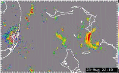
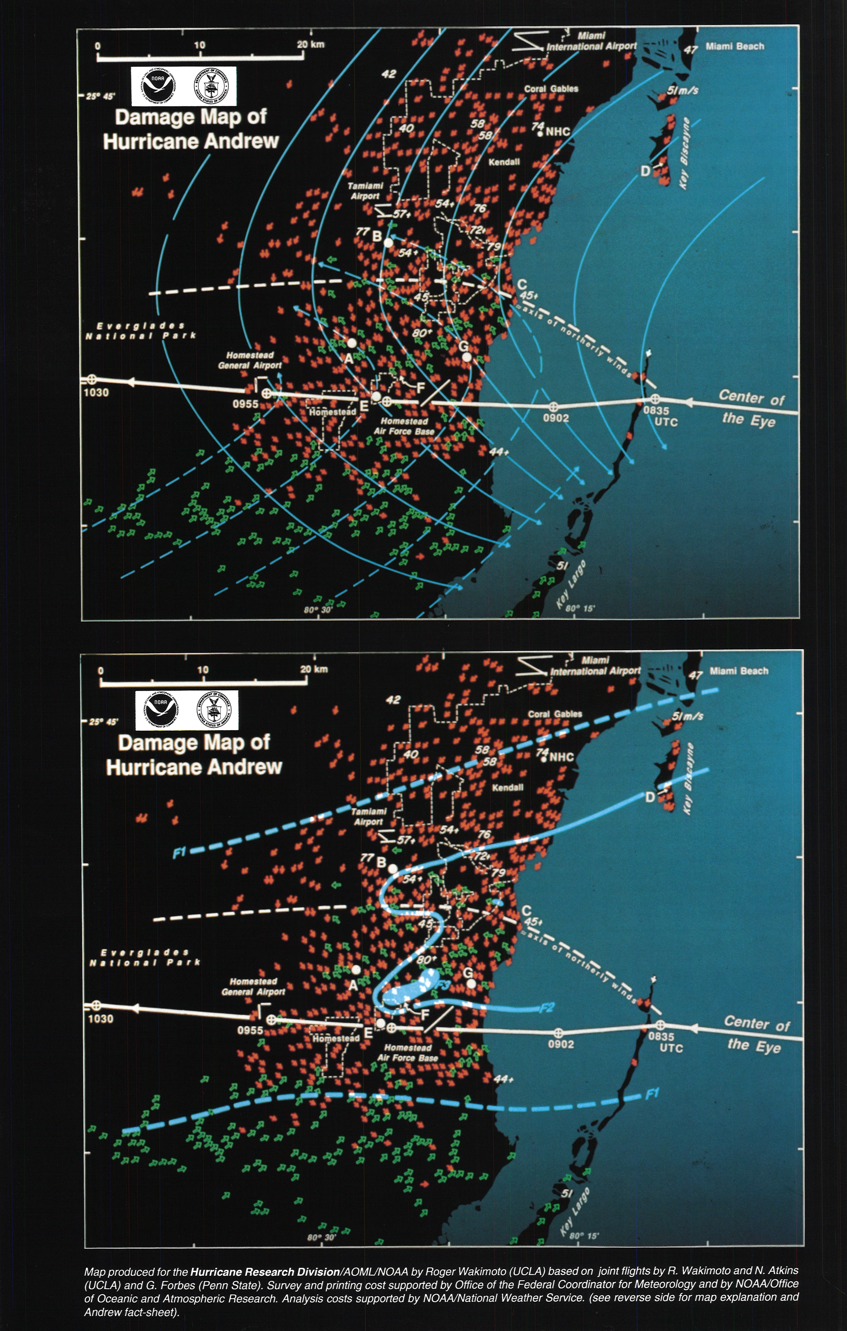
Andrew maintained its due west course and rapidly intensified. By the time it struck the Bahama Islands the winds reached a peak maximum sustained wind speed of 175 mph (280 km/hr). As Andrew approached south Florida, it underwent an eyewall replacement cycle and the top winds decreased. But as it crossed the Bahama Channel and warm Gulf Stream waters, it re-intensified. By the time it made landfall in south Dade County, the winds had risen to 165 mph (269 km/hr). The Air Force Hurricane Hunters flew a mission following the center over Homestead AFB and saw the eye had shrunk to 9-12 miles in radius.

(Bob Burpee)
The hurricane cut a swath of destruction across south Dade county that was startling. Small and fast-moving, Andrew had left the area by the afternoon of the Aug. 24th. Once helicopters were aloft, the scope of the devastation became obvious. Miles upon miles of residential and commercial buildings were torn apart. Roads were clogged with debris. Power and phone lines were down throughout the area. Emergency responders were hampered not only by blocked streets but missing road signs and familiar landmarks. People had trouble finding their homes in what had become an alien landscape. Damages in south Florida were about US$25 billion with some 40 deaths (directly and indirectly) due to Andrew.
But Andrew did not stop there. It continued into the Gulf of America and turned northwestward. Two days later, Andrew made another landfall near Morgan City, LA. The storm winds had diminished to 115 mph (185 km/hr) but produced a storm surge of 8 ft (2.4 m). The winds and rain from the hurricane left over US$1 billion in damage to Louisiana and 17 dead.
Emergency response was slow in coming at first. The extent of the damage was not known by those outside the area and it took a while for help to get organized. Eventually, troops were brought in to help police restore order. Utility crews from across the nation converged on Florida and Louisiana to restore electrical, phone, and water services. But the delays and overwhelming magnitude of the disaster may have contributed to the failure of President George H.W. Bush’s bid for re-election in November.

Although the NOAA aircraft were not flown into Andrew after the missions on the 22nd, HRD personnel were still active during and after the storm in gathering data. Bob Burpee, Sam Houston, and Peter Dodge lent a hand at the National Hurricane Center during the storm’s passage. Teams with digital radar recorders extracted radar information from the old analog WSR-57 units in Miami (until it blew off the top of the building housing the Weather Service Office), Tampa, Lake Charles and Slidell. In the confusion and destruction after the storm, researchers combed the area from any wind and pressure records that had survived. Peter Black assisted Prof. Ted Fujita in surveying and mapping the damage. And in examining the Miami radar data (before the antenna was blown off its pedestal) a ship was discovered transiting the eye prior to its Florida landfall. The ship owners were located and contacted, and accounts of the eye passage over the Bahama Channel were recovered.
All of this provided a valuable cache of information for examining hurricanes, and multiple scientific papers were written about Andrew (see below). Our understanding of storm structure and dynamics as well as wind engineering were fundamentally changed. Mesoscale features in the eyewall, such as Fujita’s “mini-swirls”, were discovered, and much-needed updates to the South Florida Building Code were implemented. The use of dropwindsonde surveys to improve track forecasts spurred NOAA to purchase the high-altitude Gulfstream IV jet in 1995 and the development of the Global Positioning System (GPS) dropwindsonde.
References
Aberson, S. D., M. L. Black, R. A. Black, R. W. Burpee, J. J. Cione, C. W. Landsea, and F. D. Marks Jr., 2006: Thirty years of tropical cyclone research with the NOAA P-3 aircraft. Bull. Amer. Met. Soc., 87, 1039-1055.
Burpee, R. W., J. L. Franklin, S. J. Lord, R. E. Tuleya, and S. D. Aberson, 1996. The impact of omega dropwindsondes on operational hurricane track forecast models. Bull. Amer. Met. Soc., 77, 925-933.
Dorst, N. M., 2007: The National Hurricane Research Project: 50 years of research, rough rides, and name changes. Bull. Amer. Met. Soc., 88, 1566-1588.
Franklin, J. L., S. E. Feuer, J. Kaplan, and S. D. Aberson, 1996: Tropical cyclone motion and surrounding flow relationships: Searching for beta gyres in omega dropwindsonde datasets. Mon. Wea. Rev., 124, 64-84.
Houston, S. H., W. A. Shaffer, M. D. Powell, and J. Chen, 1999: Comparisons of HRD and SLOSH surface wind fields in hurricanes: Implications for storm surge modeling. Wea. Forecast., 14, 671-686.
Kaplan, J., and M. DeMaria, 1995: A simple empirical model for predicting the decay of tropical cyclone winds after landfall. J. Appl. Meteor., 34, 2499-2512.
Landsea, C. W., J. L. Franklin, C. J. McAdie, J. L. Beven II, J. M. Gross, B. R. Jarvinen, R. J. Pasch, E. N. Rappaport, J. P. Dunion, and P. P. Dodge, 2004: A reanalaysis of Hurricane Andrew’s intensity. Bull. Amer. Met. Soc., 85, 1699-1712.
Powell, M. D., and S. H. Houston, 1999: Comments on “A multiscale numerical study of Hurricane Andrew (1992). Part I: Explicit simulation and verification. 127, 1707-1710.
Powell, M. D., and S. H. Houston, 1996: Hurricane Andrew’s landfall in South Florida. Part II: Surface wind fields and potential real-time applications. Wea. Forecast., 11, 329-349.,
Powell, M. D., S. H. Houston, and T. A. Reinhold, 1996: Hurricane Andrew’s landfall in South Florida. Part I: Standardizing measurements for documentation of surface wind fields. Wea. Forecast., 11, 304-328.
Powell, M. D., and T. A. Reinhold, 2007: Tropical cyclone destructive potential by integrated kinetic energy. Bull. Amer. Met. Soc., 88, 513-526.
Powell, M. D., E. W. Uhlhorn, and J. D. Kepert, 2009: Estimating maximum surface winds from hurricane reconnaissance. Wea. Forecast., 24, 868-883.
Shapiro, L. J., and J. L. Franklin, 1999: Potential vorticity asymmetries and tropical cyclone motion. Mon. Wea. Rev., 127, 124-131.
Wakimoto, R. M. , and P. G. Black, 1994: Damage survey of Hurricane Andrew and its relationship to the eyewall. Bull. Amer. Met. Soc., 75, 189-200.
Westerink, J. J., R. A. Luettich, J. C. Feyen, J. H. Atkinson, C. Dawson, J. H. Roberts, M. D. Powell, J. P. Dunion, E. J. Kubatko, and H. Pouhtaheri, 2008: A basin- to channel-scale unstructured grid hurricane storm surge model applied to Southern Louisiana. Mon. Wea. Rev., 136, 833-864.
Willoughby, H. E., and P. G. Black, 1996: Hurricane Andrew in Florida: Dynamics of a disaster. Bull. Amer. Met. Soc., 77, 543-549.