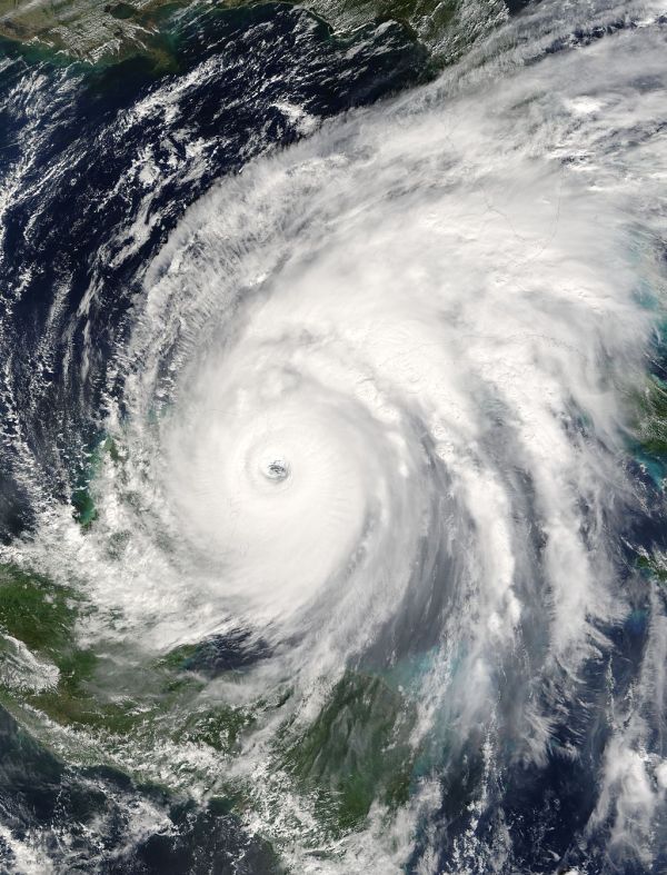


In the early morning hours of October 24, 2005, Hurricane Wilma came ashore on Florida’s Gulf coast. The storm had set records and then ravaged the Yucatan Peninsula prior to this final landfall, but it still had plenty of power left to inflict great damage on southern Florida.
The 2005 hurricane season was already one of the most active on record by the time Wilma formed on Oct. 15th in the central Caribbean Sea. The 24th tropical depression of that year formed near the Caymans and spent the next four days in the same vicinity as it slowly organized into Tropical Storm Wilma. In addition to the Air Force reconnaissance flights, NOAA 49 conducted a series of Synoptic Surveillance missions to help with forecasting Wilma’s future path. By the 19th, Wilma finally began to move westward and rapidly intensified, reaching Category Five status by late afternoon. As the storm intensified, its eye shrank down to an incredibly small 2.3 miles (3.7 km) in diameter. The Air Force measured a new record low pressure for an Atlantic hurricane of 882 mb at Wilma’s peak.

Wilma maintained Cat-5 status for about a day as it tracked slowly to the northwest. NOAA 42 carried out a reconnaissance mission late on the 20th, after this peak. The storm was moving at nearly a crawl by the time it finally struck the Mexican island of Cozumel on the evening of Oct. 21st. It had only diminished slightly from its peak, and hit Cozumel with maximum sustained winds of 150 mph (240 km/hr). The hurricane spent the next day with its center meandering over the northeast tip of the Yucatan Peninsula, pounding the area with high winds and heavy rains. NOAA 42 carried out another mission, penetrating the eye of Wilma even as it was overland.

Fortunately for the residents and tourists trapped by the storm, Wilma began to move under the influence of an approaching front on Oct. 23rd. It moved northeastward across the Gulf of America, regaining much of its strength, and monitored by NOAA 42. A day and a half later Wilma made landfall on Cape Romano, FL. There it brought winds of 120 mph (195 km/hr). The eye crossed over the state in the next five hours and did not lose much strength. By the time it passed over Jupiter, FL and moved out to sea, its maximum sustained winds had only diminished some 10 mph (20 km/hr). It left behind an astonishingly wide swath of damage across south Florida. Wilma then raced out to sea, leaving 87 dead and nearly US$30 billion in damage, the most indirect deaths and most damage being in the United States. Because destruction to the infrastructure was so broad over Florida, it took nearly two weeks for power to be restored for most of the area. As a consequence, the State of Florida mandated that south Florida gas stations and grocery stores would need to have backup generators.
Papers written by HRD personnel using Wilma data:
Kaplan, J., C. M. Rozoff, M. DeMaria, C. R. Sampson, J. P. Kossin, C. S. Velden, J. J. Cione, J. P. Dunion, J. A. Knaff, J. A. Zhang, J. F. Dostalek, J. D. Hawkins, T. F. Lee, and J. E. Solbrig, 2015: Evaluating Environmental Impacts on Tropical Cyclone Rapid Intensification Predictability Utilizing Statistical Models. Wea. Forecasting, 30, 1374–1396.
Susca-Lopata, G., J. Zawislak, E. J. Zipser, and R. F. Rogers, 2015: The Role of Observed Environmental Conditions and Precipitation Evolution in the Rapid Intensification of Hurricane Earl (2010). Mon. Wea. Rev., 143, 2207–2223.
Hazelton, A. T., R. Rogers, and R. E. Hart, 2015: Shear-Relative Asymmetries in Tropical Cyclone Eyewall Slope. Mon. Wea. Rev., 143, 883–903.
DiNapoli, S. M., M. A. Bourassa, and M. D. Powell, 2012: Uncertainty and Intercalibration Analysis of H*Wind. J. Atmos. Oceanic Technol., 29, 822–833.
Gopalakrishnan, S. G., S. Goldenberg, T. Quirino, X. Zhang, F. Marks Jr., K.-S. Yeh, R. Atlas, and V. Tallapragada, 2012: Toward Improving High-Resolution Numerical Hurricane Forecasting: Influence of Model Horizontal Grid Resolution, Initialization, and Physics. Wea. Forecasting, 27, 647–666.
Aberson, S. D., 2010: 10 Years of Hurricane Synoptic Surveillance (1997–2006). Mon. Wea. Rev., 138, 1536–1549.
Aberson, S. D., 2008: Large Forecast Degradations due to Synoptic Surveillance during the 2004 and 2005 Hurricane Seasons. Mon. Wea. Rev., 136, 3138–3150.
Cerveny, R. S., J. Lawrimore, R. Edwards, and C. Landsea, 2007: Extreme Weather Records. Bull. Amer. Meteor. Soc., 88, 853–860.
Powell, M. D., and T. A. Reinhold, 2007: Tropical Cyclone Destructive Potential by Integrated Kinetic Energy. Bull. Amer. Meteor. Soc., 88, 513–526.
Rogers, R., S. Aberson, M. Black, P. Black, J. Cione, P. Dodge, J. Gamache, J. Kaplan, M. Powell, J. Dunion, E. Uhlhorn, N. Shay, and N. Surgi, 2006: The Intensity Forecasting Experiment: A NOAA Multiyear Field Program for Improving Tropical Cyclone Intensity Forecasts. Bull. Amer. Meteor. Soc., 87, 1523–1537.
Aberson, S. D., M. L. Black, R. A. Black, J. J. Cione, C. W. Landsea, Fr. D. Marks Jr., and R. W. Burpee, 2006: Thirty years of tropical cyclone research with the NOAA P-3 aircraft. Bull. Amer. Meteor. Soc., 87, 1039–1055.